ATLAS of ANTIENT GEOGRAPHY by SAMUEL BUTLER 1843John McInnis Auctioneers,LLC4.6(502)See Sold PriceFeb 24, 2024
18TH C. ANTIQUE MAP: FRENCH & INDIAN WAR, FRAMEDThomaston Place Auction Galleries4.4(386)See Sold PriceFeb 24, 2024
Rand McNally Railroad Map Cabinet w/ 21 Railroad MapsRail & Road Auctions4.6(165)See Sold PriceMar 08, 2024
Keith Haring - Ink on New York Map, Best Buddies, Inscribed, Signed, and DatedSapphire Auction Gallery4(67)See Sold PriceMar 02, 2024
LATE 17TH C. FRENCH MAP OF THE NEW WORLD BY ALEXIS-HUBERT JAILLOT (1632-1712)Thomaston Place Auction Galleries4.4(386)See Sold PriceFeb 24, 2024
Central Railroad of New Jersey Map of Sandy Hook Route-ca. 1903JM Hobby Supply and Railroad Artifact Auctions4.4(126)See Sold PriceFeb 24, 2024
Lot of Six Mixed Atlas Box Cars-HO Scale-New in BoxJM Hobby Supply and Railroad Artifact Auctions4.4(126)See Sold PriceFeb 25, 2024
Rand McNally/Santa Fe Railroad Map of Iowa-1912JM Hobby Supply and Railroad Artifact Auctions4.4(126)See Sold PriceFeb 24, 2024
NICOLAES VISSCHER (NETHERLANDS, 1618-1709) MAP OF THE NEW WORLDThomaston Place Auction Galleries4.4(386)See Sold PriceFeb 24, 2024
17TH C. WORLD MAP BY NICOLAES VISSCHER (NETHERLANDS, 1618-1709)Thomaston Place Auction Galleries4.4(386)See Sold PriceFeb 24, 2024
Lot of Six Mixed Atlas Cabooses-HO Scale-New in BoxJM Hobby Supply and Railroad Artifact Auctions4.4(126)See Sold PriceFeb 25, 2024
SoldFRAMED FRENCH MAP OF NORTH AMERICA, 19TH C.Map: "Carte Physique et Politique de L'Amerique du Nord," Claude-Joseph Drioux (French, 1820-1898) and Charles Leroy (French, fl.1835-1890), published by Eugene Belin, engraved by Jenotte, printed bySee Sold Price
Sold(2) JOHN TALLIS ATLAS MAPS NORTH & SOUTH AMERICA(lot of 2) Framed hand-colored engravings on paper, maps of North and South America, mid 19th c., published in John Tallis's "Illustrated Atlas," drawn and engraved by John Rapkin, with illustrated viSee Sold Price
SoldEarly map of North AmericaEarly map of North America French, 18th/19th centuryAMERIQUE SEPTENTRIONALEengraving, framed, by John Mitchell, and published by Le Rougesight size: H19" W23"*Provenance: Deaccessioned from the ColumbSee Sold Price
SoldTwo Mid 19th Century United States Framed Maps1. Hand colored map "United States of North America / North Central Sheet", depicting Midwest with Minnesota Territory pre-Dakota, c. 1863, drawn and engraved by T. Ettling, Weekly Dispatch Atlas; matSee Sold Price
SoldFRAMED FRENCH MILITARY ARMED FORCES MAPFramed French map, late 19th/ early 20th c., by Henri Bressler, decorative map of France surrounded by images of the French armed forces, over inset map of Corse and Algeria, published by de VaugirardSee Sold Price
SoldSurvey Maps of North and South AmericaFifteen Antique Survey Maps of North and South America , 19th c., many printed by J. Bien, sheets 19 in. x 22 in. to 27 1/2 in. x 35 1/2 in Provenance: Property deaccessioned from the Louisiana StateSee Sold Price
Soldc. 1785, French Map of North AmericaMapsHand-colored map of North America c. 1785, French Map of North America Printed in Holland, Very Fine. This detailed 9.25” x 12” hand-colored map has been matted to an overall size of 1See Sold Price
Soldc. 1785, French Map of North AmericaMapsHand-colored map of North America c. 1785, French Map of North America Printed in Holland, Very Fine. This detailed 9.25" x 12" hand-colored map has been matted to an overall size of 16&See Sold Price
Soldc. 1785, French Map of North AmericaMapsHand-colored map of North America c. 1785, French Map of North America Printed in Holland, Very Fine. This detailed 9.25” x 12” hand-colored map has been matted to an overall size of 1See Sold Price
(19th c.) Map of North AmericaL'Amerique Septentrionale with 17th century features Condition: toning Size: 11" x 8"toning11" x 8"See Sold Price
SoldTwo 19th C. Maps of North AmericaLot of two early 19th C. maps of North America. Various dates and publishers.See Sold Price
SoldUNITED STATES 1860 MAP, J.W. LOWRY, TERRITORIESFramed map: "The United States of North America (General Map)" c. 1860, drawn and engraved by J.W. Lowry (Joseph Wilson Lowry, British, 1803-1879), published by Blackie & Son, Glasgow, Edinburgh & LonSee Sold Price
SoldNORTH AMERICA COLORED MAP, C. 1763, POSTLETHWAYTFramed antique map c. 1770, "North America, Plate 1" from the publication "Dictionary of Trade and Commerce" by Malachy Postlethwayt (British, 1707-1767), hand colored, also reading "North America, PeSee Sold Price
SoldNORTH AMERICA COLORED MAP, C. 1763, POSTLETHWAYTFramed antique map c. 1770, "North America, Plate III" and "Part of North America, Plate IV", from the publication "Dictionary of Trade and Commerce" by Malachy Postlethwayt (British, 1707-1767), handSee Sold Price
Sold1779 French Engraved Framed Map Americas NR1779 French engraved framed map of North & Central America (probably printed about 100 years later) (Center fold with small, minor tears & holes; nice old appearance; frame much later; Old Print ShopSee Sold Price
PRINTED COTTON MAP OF NORTH AMERICA, C.1830PRINTED COTTON MAP OF NORTH AMERICA, C.1830. FRAMED 29 X 35" (MOUNTED)See Sold Price
SoldUNITED STATES 1860 MAP, J.W. LOWRY, TERRITORIESFramed map of "The United States of North America (General Map)", c. 1860, "drawn and engraved by" J.W. Lowry (Joseph Wilson Lowry, British, 1803-1879), published by Blackie & Son, Glasgow, EdinburghSee Sold Price
Sold19th c. Schoolgirl map of N. AmericaHand drawn and colored school girl map of North America by Helen C. Bingham. Map depicts British America, Russian America, the United States, Upper California, Mexico, Guatemala, the top of South AmerSee Sold Price
Sold18th Century French Map of North AmericaL’Amerique Septentrionale. Daniel de la Feuille (1640-1709). Engraved map with hand color in full. Amsterdam, 1702 or 1706. 6 x 8 inches visible, 13 x 14 1/2 inches framed. Nicely colored early 18thSee Sold Price
Sold19thc Polar Regions British North America MapA hand-colored map titled "Polar Regions Including British North America & c.. Drawn by J. Assheton, Engraved on steel by J. Shury, Published London by Thomas Tegg, 73 Cheapside. c.1830s. Measures 9.7See Sold Price
SoldTwo maps of North America by R.W. Seale publishedby University Magazine. North America- Site: 10.75"H x 14"W; Frame: 17.5"H 21.25"W; Canada- Site: 10.5"H x 13.75"W; Frame: 17.5"H x 21.25"W. Circa - Late 19th C.See Sold Price
SoldANTIQUE NORTH AMERICA MAP C. 1780, WILLIAM GUTHRIEFramed antique map, c. 1780, "A General Map of North America from the best Authorities", believed to be from "A New Geographical, Historical, and Commercial Grammar and Present State of the Several KiSee Sold Price
SoldMcKinney & Hall, "Waa-Pa-Shaw, Sioux Chief," 19th c., cMcKinney & Hall, "Waa-Pa-Shaw, Sioux Chief," 19th c., colored print, from "The History of the Indian Tribes in North America," framed, H.- 15 3/4 in., W.- 11 5/8 in.See Sold Price
McKenney and Hall, "Tuko-See-Matla, A Seminole Chief,"McKenney and Hall, "Tuko-See-Matla, A Seminole Chief," 19th c., colored lithograph, from the "History of the Indian Tribes of North America," framed, H.- 17 in., W.- 13 in.See Sold Price
18TH C. ANTIQUE MAP: FRENCH & INDIAN WAR, FRAMEDThomaston Place Auction Galleries4.4(386)See Sold PriceFeb 24, 2024
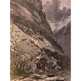
19thc North Carolina Engraving, Farm On The French Broad RiverConnoisseur Auctions4(333)See Sold PriceMar 02, 2024
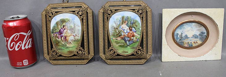
Three(3) Framed 19thC. English and French PrintsMid-Hudson Auction Galleries4.4(468)See Sold PriceFeb 24, 2024
19th C. French Floral Watercolor Framed Floral Painting, Signed By G.StokesAuction Plus, Inc.4.3(4)See Sold PriceMar 01, 2024
3 Antique Miniatures (1) 19Th C. French Signed J. FarcyRalph Fontaine Heritage Auctions Inc.4.7(235)See Sold PriceFeb 25, 2024
Two (2) Antique 18th C. Copper Engraved Framed Maps - America & EuropeMagnusson Art Group4.5(46)See Sold PriceMar 14, 2024
19th C. Sevres Hand Painted Framed Plaque. Rills SignedFive Star Auctions4.2(3)See Sold PriceFeb 29, 2024
19th C. French Gilt Framed Oval Pastel Painting Of Cherubs, Pauline Viancin SignedFive Star Auctions4.2(3)See Sold PriceFeb 29, 2024
Children Still Life, 19th C. Oil On Canvas Framed Painting, Leon Bazille Perrault (1832 - 1908)Five Star Auctions4.2(3)See Sold PriceFeb 29, 2024
A Large 19th C. French Engraved Figural Bronze Framed wall HangingFive Star Auctions4.2(3)See Sold PriceFeb 29, 2024
1822 MAP of NORTH & SOUTH AMERICA GEOGRAPHICAL STATISTICAL HISTORICAL antiqueJasper524.5(9.8k)See Sold PriceFeb 27, 2024
New and Correct Map of North America With the West India Islands,Jasper524.5(9.8k)See Sold PriceFeb 27, 2024
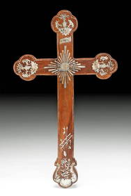
19th C. Asian Rosewood Apostle's Cross, Nacre InlayArtemis Fine Arts4.8(1.4k)See Sold PriceFeb 26, 2024