SoldFour 19th C. Maps of the Western HemisphereLot of four early 19th C. maps of countries in the western hemisphere, including St. Vincent, Grenada/Tobago/Curacao/Trinidad, Caracas/Guiana/Peru/Chile/La Plata. Various dates and publishers.See Sold Price
SoldCollection of (4) 19th C. Maps/Portions of ChartsCollection of four 19th Century framed maps and portions of charts including the Mississippi River, Falmouth England, Plymouth Sound and the Western Hemisphere. All frames approximately 19" x 15". ConSee Sold Price
Sold5 maps: 19th C., Western Hemisphere, color.[AMERICAS]. 5 Maps. Hand-colored, one in outline. Varying degrees of toning, mostly in and near margins, few small chips at edge, other defects noted. ++ Map of the United States And Territories. TogeSee Sold Price
Sold19th C. Western & Northern Hemisphere MapsTwo 19th century maps, including one of the Northern hemisphere, drawn and engraved for John Thomson Co. New General Atlas, 1814 [26" H x 21" W], together with a map of the Western hemisphere, drawn aSee Sold Price
SoldFour 17th-18th C. Maps: Desing, Manesson-MallettCollection of four 17th and 18th European maps, Item 1: P. A. Desings map of the western hemisphere. Hand colored copper engraving published in 1741. 6 3/8" H x 5 3/4" W. Items 2 and 3: Two Manesson-See Sold Price
Soldc. 1804 Map of Western Hemispherec. 1804 “WESTERN HEMISPHERE” by S. Neele, Choice Extremely Fine. 20.25” x 16.25”, a nicely hand-colored, copper-engraved map. In this early 19th century map, the Southwest UnitSee Sold Price
Soldc. 1804 Map of Western HemisphereMapsc. 1804 “WESTERN HEMISPHERE” by S. Neele, Choice Extremely Fine. 20.25” x 16.25”, a nicely hand-colored, copper-engraved map. In this early 19th century map, the SouthwestSee Sold Price
Soldc. 1804 Map of Western HemisphereMapsc. 1804 “WESTERN HEMISPHERE” by S. Neele, Choice Extremely Fine. 20.25” x 16.25”, a nicely hand-colored, copper-engraved map. In this early 19th century map, the SouthwestSee Sold Price
SoldJ. H. Colton, "Eastern Hemisphere," and "Western HJ. H. Colton, "Eastern Hemisphere," and "Western Hemisphere," 19th c., pair of colored maps, framed, H.- 18 1/4 in., W.- 15 3/8 in.See Sold Price
SoldJ. H. Colton, "Eastern Hemisphere," and "Western HJ. H. Colton, "Eastern Hemisphere," and "Western Hemisphere," 19th c., pair of colored maps, framed, H.- 18 1/4 in., W.- 15 3/8 in.See Sold Price
SoldWilliam Darton, (10) antique mapsWilliam Darton, (10) antique maps, William Darton (British, 19th c.), "The Western Hemisphere or New World", "South America", etc., 12.75"h x 10.5"w (sheet), unframed Provenance: Property from a majorSee Sold Price
SoldFour 19th C. Maps of the United StatesLot of four mid/late 19th C. maps of the United States. Various dates and publishers.See Sold Price
SoldFour 19th C. Maps of the WorldLot of four 19th C. maps of the world. Various dates and publishers.See Sold Price
SoldFour 19th C. Maps of PalestineLot of four 19th C. maps of Palestine and its surrounding countries. Various dates and publishers.See Sold Price
SoldFour 19th C. Maps of U.S. StatesLot of four 19th C. maps of Ohio and Indiana. Various dates and publishers.See Sold Price
SoldEARLY 18th C. MAP, WESTERN HEMISPHERE, DE FERTitle: Map: L'Amerique Meridionale et Septentrionale, Pub: Nicholas de Fer, Date: (1700) Circa 1705, Medium: HC Engraving, Paper size: 11 3/4 x 17, Inscribed: Publisher identified in the matrix, CondiSee Sold Price
Sold1862 Bowen Civil War Map, Other 19th C. MapsFour 19th c. maps: 1. Framed Bowen's "Map of the Field Operations of the Army of Virginia during the Months of July and August 1862"; report of Maj. Gen. John Pope to the Committee on the Conduct of tSee Sold Price
Soldc. 1755 Map of the Western HemisphereMapsc. 1755 “A New Map of North America,” by Tirion c. 1755 “NIEUWE KAART VAN AMERICA” (A New Map of North America), by Isaac Tirion, Choice Extremely Fine. Handcolored in outlSee Sold Price
Soldc. 1755 Map of the Western HemisphereMapsc. 1755 “A New Map of North America,” by Tirion c. 1755 “NIEUWE KAART VAN AMERICA” (A New Map of North America), by Isaac Tirion, Choice Extremely Fine. Handcolored in outlSee Sold Price
SoldMAP:MID 19th C. DOUBLE HEMISPHERE MAP, LITHOArtist: J.H. Brightly, Title: A New Map of the World on the Globular Projection, Pub: Thomas Cowperthwait and Co., Date: 1850, Medium: HC Lithograph, Paper size: 13 1/4 x 17 1/4, Inscribed: PublisherSee Sold Price
SoldNine 19th C. Maps of PennsylvaniaLot of nine 19th C. maps of central and western Pennsylvania towns. Various dates and publishers.See Sold Price
Sold1850 Map WESTERN HEMISPHERE by TallisHistoric Maps Decorative 1850 Tallis "WESTERN HEMISPHERE" Map c. 1850, Hand-colored Map of the "WESTERN HEMISPHERE," drawn by J. Rapkin, published by The London Printing and Publishing Company (John TSee Sold Price
SoldPHILLIPE DE PRETOT (FRENCH, C. 1710-1787) MAP OFPHILLIPE DE PRETOT (FRENCH, C. 1710-1787) MAP OF WESTERN HEMISPHERE, hand-colored engraving on paper, titled "Carte Nouvelle D'Amerique pour les premieres etudes". Published in Paris, 1769. Matted undSee Sold Price
ANTIQUE HAND DRAWN W. HEMISPHERE MAP19th century hand drawn map WESTERN HEMISPHERE in pen & ink & pencil. Framed under glass, unsigned. Map is 13.5 x 12.5, framed 18.5 x 17.5 inches. Excellent condition.See Sold Price
19thc Colton Map, Comparitive Size of Lakes & IslandsConnoisseur Auctions3.9(337)See Sold PriceFeb 24, 2024
RUSSIAN ORTHODOX GILT BRONZE FOLDING TRAVEL ICONAustin Auction Gallery4.7(1.2k)See Sold PriceFeb 25, 2024
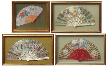
Group of Four Folding Hand Fans, 19th c., Largest- Seaside- H.- 9 in., W.- 18 in. (4 Pcs.)Crescent City Auction Gallery4.3(233)See Sold PriceMar 01, 2024
Group of Four Ninth Plate Photographs, 19th c., consisting of three tintypes of gentlemen withCrescent City Auction Gallery4.3(233)See Sold PriceMar 01, 2024
Four Pieces of Southern Silver, 19th c., consisting of a Wood & Hughes Sterling Child's cup,Crescent City Auction Gallery4.3(233)See Sold PriceMar 01, 2024
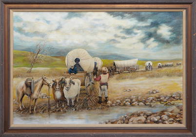
American School, "Western Scene," 19th c., H.- 24 in., W.- 36 in., Framed- H.- 28 3/4 in., W.- 40Crescent City Auction Gallery4.3(233)See Sold PriceMar 01, 2024
Chinese Four Character Mark Porcelain Plate 19th CPassion For Antiques4(24)See Sold PriceFeb 29, 2024
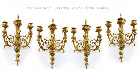
A Set Of Four 19th C. French Louis XVI Ormolu Sconces, Attrib. Henry DassonFive Star Auctions4.2(3)See Sold PriceFeb 29, 2024
Map: A 19thC engraved and hand coloured map of Buckingham titled A New Map of BuckinghamshireClaydon Auctioneers Ltd4.3(125)See Sold PriceFeb 26, 2024
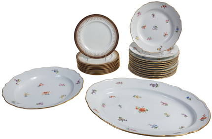
Twenty Four Pieces of Porcelain Dinnerware, 19th c., Platter- H.- 2 7/8 in., W.- 18 7/8 in., D.- 13Crescent City Auction Gallery4.3(233)See Sold PriceMar 08, 2024
Rare 19thc Colton Map, Argentine Republic, Chile, Uruguay, PataguayConnoisseur Auctions3.9(337)See Sold PriceMar 16, 2024