SoldFour 19th C. Maps of the United StatesLot of four mid/late 19th C. maps of the United States. Various dates and publishers.See Sold Price
Sold1862 Bowen Civil War Map, Other 19th C. MapsFour 19th c. maps: 1. Framed Bowen's "Map of the Field Operations of the Army of Virginia during the Months of July and August 1862"; report of Maj. Gen. John Pope to the Committee on the Conduct of tSee Sold Price
Sold19thc Map of Palestine, Judea,Samaria, Jerusalem1855 1st edition Colton's Atlas map, published by J. H. Colton & Co., New York, pg no. 26. Features Palestine, Arabia, Judea, Jerusalem, Samaria, Galilee, The Mediterranean Sea, The Dead Sea. 15" X 18See Sold Price
Sold(4) Maps of Palestine 19th c.Includes: A New Map of Palestine of the Holy Land. 12 3/8" x 15" folded, Mitchell 1867. Hocland von Juda 10 5/8" x 16 3/8" Andreas Atlas 1893 (p.109). Palestine 13 5/8" x 20 3/8" folded, Appleton 1891See Sold Price
SoldFour Antique Continental MapsFour Antique Continental Maps , 17th to 19th c., incl. map of Ireland, British Colonies, Virginia, and two bird's-eye-views, largest 18 3/4 in. x 26 in Provenance: Property deaccessioned from the LouiSee Sold Price
SoldLot of 4 Russian Books, 19th C. Bible, MapsLot of four likely Russian books with what look like Cyrillic lettering. Includes a Bible and a book of that appears to be about seafaring with a large fold-out river map.Dimensions range from 9.75 inSee Sold Price
SoldTRANQUILLO MOLLO ATLASTRANQUILLO MOLLO ATLAS; Thirty-four maps out of an original fifty-two include America, United Kingdom, Australia, etc., Vienna, late 18th/early 19th c.; Most maps with color; 15'' x 20''See Sold Price
Sold(4) 19th c. hand colored maps of ConnecticutGrouping of four circa 1867 hand colored maps and one black and white advertisement from the "Atlas of New York and Vicinity" by Beers, Ellis & Soule, the drawings based on land surveys performed undeSee Sold Price
Sold(4) Mid 19th c. hand colored maps of New YorkGrouping of four circa 1867 hand colored maps and one black and white advertisement from the "Atlas of New York and Vicinity" by Beers, Ellis & Soule, the drawings based on land surveys performed undeSee Sold Price
Sold(4) Mid 19th c. hand colored maps of New YorkGrouping of four circa 1867 hand colored maps from the "Atlas of New York and Vicinity" by Beers, Ellis & Soule, the drawings based on land surveys performed under the direction of F.W. Beers, includeSee Sold Price
Sold(4) 19th c. hand colored maps of ConnecticutGrouping of four circa 1867 hand colored maps from the "Atlas of New York and Vicinity" by Beers, Ellis & Soule, the drawings based on land surveys performed under the direction of F.W. Beers, includeSee Sold Price
Sold(4) 19th c. hand colored maps of ConnecticutGrouping of four circa 1867 hand colored maps from the "Atlas of New York and Vicinity" by Beers, Ellis & Soule, the drawings based on land surveys performed under the direction of F.W. Beers, includeSee Sold Price
SoldEnglish Ebonized Map Rack, 19th c., on turned suppEnglish Ebonized Map Rack, 19th c., on turned supports, the top sectioned to hold rolled maps, with four Louisiana coastal maps for demonstration purposes, H.- 35 1/2 in., W.- 22 1/2 in., D.- 15 1/2 iSee Sold Price
SoldMAPS OF NEW JERSEY AND PENNSYLVANIAFour: All engraved on laid paper (one in color), 18th/19th c.; Largest: 53 1/4" x 21 3/4"See Sold Price
Sold18th/19th C. Maps and Colored Engravings(4)18th and 19th century maps and colored engravings. Group of four. Measure 13.375 in. - 18.5 in. x 9.625 in. - 11.25 in. F-G/G to G-VG. Unframed, loose and not mounted or glued down. If lot is absent oSee Sold Price
Sold19thc Hand-colored Harper's Weekly Engravings, St.Pair of 1861 Harper's Weekly pages with hand-colored maps & engravings of river boats, The Mississippi River, St Louis & Jefferson City. Four hand-colored engravings total between 2 pages dated July 6See Sold Price
SoldFifteen 19th & Early 20th C. BooksA lot of 15 books to include: "Hampshire Days" (W.H. Hudson, 1923); "The Four Gardens" (Handasyde, 1912); "Of Making Many Books" (R. Burlingame, 1946); "Handbook of the New Library of Congress" (H. SmSee Sold Price
SoldFour Cypriot .830 Silver Holloware Piecesthe first a souvenir bowl with map of Cyprus within a medallion on one side, the underside engraved "To A.H.E.P.A. / In Appreciation of Its Strong Support to Cyprus / C. E. Paraskevaides / 19th AprilSee Sold Price
SoldFOUR MAPS OF INDIAN TERRITORY AND SOUTH WEST, 19TH CEN.Includes an 1872 Gray's Atlas map of Indian Territory, by G.W. & C.B. Colton, 13.75 x 17 inches. An A.A. Grant 'Railroad and County Map of Indian Terr.,' 17.25 x 23.5 inches. Two similar Wells, FargoSee Sold Price
SoldEgypyt 19th Century Lot of 4 MapsAll of Egypt, some showing Arabia as well. Examples by A & C Black, Arrowsmith, Vuillemin, and Picturesque Palestine. Paper Size: Up to 18 x 12.5 inch (46 x 32cm) Good ConditionSee Sold Price
SoldFour 19th c. bronze figures incl. the Hindu deity ShivaFour 19th c. bronze figures incl. the Hindu deity Shiva and Buddhist Maitreya, tallest 10"h.See Sold Price
SoldFOUR 19TH C. EUROPEAN CARVED IVORY ART OBJECTSThe sizes range from 1.5 x 3.5 inches up to 7 x 3.5 inches. This lot will be accompanied by a signed affidavit from the client that this object was in the United States prior to January 18, 1990, andSee Sold Price
SoldFour 19th C. Photographic Travel AlbumsFour 19th C. Photographic Travel Albums.120+ pages of photos 1). Photos of England , Germany, Switzerland, Mt. Blanc and Glaciers. 2). Milano, Geneva, Pisa, Florence, Venice, Verona 3). Bavaria, ViennSee Sold Price
SoldFour 19th c. Asian Blanc-de-Chine figures, largestFour 19th c. Asian Blanc-de-Chine figures, largest 11.75"h.x4.5"w.See Sold Price
19thc Colton Map, Comparitive Size of Lakes & IslandsConnoisseur Auctions3.9(337)See Sold PriceFeb 24, 2024
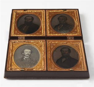
RUSSIAN ORTHODOX GILT BRONZE FOLDING TRAVEL ICONAustin Auction Gallery4.7(1.2k)See Sold PriceFeb 25, 2024
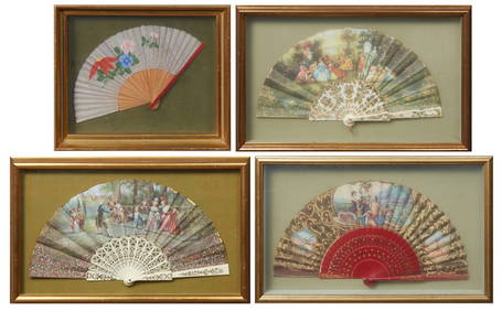
Group of Four Folding Hand Fans, 19th c., Largest- Seaside- H.- 9 in., W.- 18 in. (4 Pcs.)Crescent City Auction Gallery4.3(233)See Sold PriceMar 01, 2024
Group of Four Ninth Plate Photographs, 19th c., consisting of three tintypes of gentlemen withCrescent City Auction Gallery4.3(233)See Sold PriceMar 01, 2024
Four Pieces of Southern Silver, 19th c., consisting of a Wood & Hughes Sterling Child's cup,Crescent City Auction Gallery4.3(233)See Sold PriceMar 01, 2024
Chinese Four Character Mark Porcelain Plate 19th CPassion For Antiques4(24)See Sold PriceFeb 29, 2024
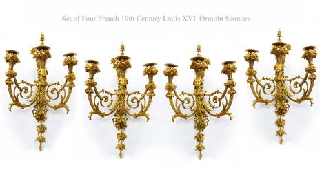
A Set Of Four 19th C. French Louis XVI Ormolu Sconces, Attrib. Henry DassonFive Star Auctions4.2(3)See Sold PriceFeb 29, 2024
Four 19thC Gothic side chairs, the top rails having large pierced trefoil decoration and the midClaydon Auctioneers Ltd4.3(125)See Sold PriceFeb 26, 2024
Map: A 19thC engraved and hand coloured map of South America. Published by the Society for theClaydon Auctioneers Ltd4.3(125)See Sold PriceFeb 26, 2024
Map: A 19thC engraved and hand coloured map of St. Petersburg / Sanktpeterburga by W. B. Clarke.Claydon Auctioneers Ltd4.3(125)See Sold PriceFeb 26, 2024
Map: A 19thC engraved map titled Gloucestershire from the Best Authorities, after John Cary. Approx.Claydon Auctioneers Ltd4.3(125)See Sold PriceFeb 26, 2024
Map: A 19thC engraved and hand coloured map of Buckingham titled A New Map of BuckinghamshireClaydon Auctioneers Ltd4.3(125)See Sold PriceFeb 26, 2024
Map: A 19thC engraved map of West Riding, titled A Map of the North Part of the West Riding ofClaydon Auctioneers Ltd4.3(125)See Sold PriceFeb 26, 2024
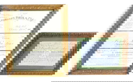
Four 19thC Welsh receipts / bill heads / compliment slips relating to Edward Finch & Co. Ltd.Claydon Auctioneers Ltd4.3(125)See Sold PriceFeb 26, 2024
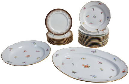
Twenty Four Pieces of Porcelain Dinnerware, 19th c., Platter- H.- 2 7/8 in., W.- 18 7/8 in., D.- 13Crescent City Auction Gallery4.3(233)See Sold PriceMar 08, 2024
Rare 19thc Colton Map, Argentine Republic, Chile, Uruguay, PataguayConnoisseur Auctions3.9(337)See Sold PriceMar 16, 2024