ATLAS of ANTIENT GEOGRAPHY by SAMUEL BUTLER 1843John McInnis Auctioneers,LLC4.5(505)See Sold PriceFeb 24, 2024
18TH C. ANTIQUE MAP: FRENCH & INDIAN WAR, FRAMEDThomaston Place Auction Galleries4.4(394)See Sold PriceFeb 24, 2024
Rand McNally Railroad Map Cabinet w/ 21 Railroad MapsRail & Road Auctions4.6(165)See Sold PriceMar 08, 2024
Keith Haring - Ink on New York Map, Best Buddies, Inscribed, Signed, and DatedSapphire Auction Gallery4.1(67)See Sold PriceMar 02, 2024
LATE 17TH C. FRENCH MAP OF THE NEW WORLD BY ALEXIS-HUBERT JAILLOT (1632-1712)Thomaston Place Auction Galleries4.4(394)See Sold PriceFeb 24, 2024
Central Railroad of New Jersey Map of Sandy Hook Route-ca. 1903JM Hobby Supply and Railroad Artifact Auctions4.4(127)See Sold PriceFeb 24, 2024
Lot of Six Mixed Atlas Box Cars-HO Scale-New in BoxJM Hobby Supply and Railroad Artifact Auctions4.4(127)See Sold PriceFeb 25, 2024
Rand McNally/Santa Fe Railroad Map of Iowa-1912JM Hobby Supply and Railroad Artifact Auctions4.4(127)See Sold PriceFeb 24, 2024
NICOLAES VISSCHER (NETHERLANDS, 1618-1709) MAP OF THE NEW WORLDThomaston Place Auction Galleries4.4(394)See Sold PriceFeb 24, 2024
17TH C. WORLD MAP BY NICOLAES VISSCHER (NETHERLANDS, 1618-1709)Thomaston Place Auction Galleries4.4(394)See Sold PriceFeb 24, 2024
Lot of Six Mixed Atlas Cabooses-HO Scale-New in BoxJM Hobby Supply and Railroad Artifact Auctions4.4(127)See Sold PriceFeb 25, 2024
SoldFive Maps of Areas in ChinaFive Maps of Areas in China 20th century, includes five maps drawn for Crow's Handbook For China, locations represented include: Soochow, Shanghai, Tientsin, Hong Kong, and China, all framed, not examSee Sold Price
SoldAsia.- Lizars (W.) and others. Five maps of China,Asia.- Lizars (W.) and others. Five maps of China, including Lizars' map of the mainland, Robert Wilkinson's 'China, Contains 15 Subject Provinces', 2 maps of mainlaind China by Fullarton & Co., and aSee Sold Price
SoldSET OF FIVE MAP OF CHINAA.J.Johnson, New York 1862, #97. Colton's China, New York, 1855, #28. Colton's Asian, New York, 1856 #24. Cowperthwait's China, Pennsylvania, 1850, #70. S.G. Goodrish, Massassachusetts 1841, #50. thesSee Sold Price
SoldFünf Karten zu fränkischen Gebieten — 17. und 18.Five maps of Franconian areas — 17th and 18th C. ''Totius Franconiae Nova Descriptio'', cartographer Gerhard Mercator; copper engraving published by Joan Janssonius, Amsterdam around 1638; EnglSee Sold Price
SoldSet of five framed Cary's Atlas maps including ChinaSet of five framed Cary's Atlas maps including China Great Provinces, German, Russian Empire in Europe and Asia, Europe, and Asia, all framed and matted. 13 1/2" x 15 1/2" to 16" x 18 1/2" ProvenanceSee Sold Price
SoldTartaria Five Magnichami Imperivm Map25 x 21 Frame Size, Image Size, 19 ½” x 15” Tartaria Five Magnichami Imperivm Map Depicts Europe, ChinaSee Sold Price
SoldFIVE BLUEBACK CHARTS OF NAVIGATIONAL AREAS AROUND CHINAFIVE BLUEBACK CHARTS OF NAVIGATIONAL AREAS AROUND CHINA19th CenturyIncludes charts of the China Sea and the East Indian Archipelago.See Sold Price
SoldFive pilot's silk escape maps of Indo-China,Five pilot's silk escape maps of Indo-China,See Sold Price
Wit, Frederick de. World and continents (set)Wit, Frederick de Set of Five Maps (Wit) 1670 Copperplate engraving; coloured Printed area: World: 48.8 x 57.6 cm; 19.2 x 22.7 in Africa: 49.2 x 58 cm; 19.4 x 22.8 in America: 49.2 x 58.3 cm; 19.4 x 2See Sold Price
Coronelli, Vincenzo Maria. World and continents (set)Coronelli, Vincenzo Maria Set of Five Maps (Coronelli) 1691 Copperplate engraving; coloured Printed area: South America: 59.8 x 87.8 cm; 23.5 x 34.6 in Europe und Asia: 60.2 x 89.2 cm; 23.7 x 35.1 inSee Sold Price
SoldFive maps of Asia and the Middle East by TallisTitle: Five maps of Asia and the Middle East by John Tallis Author: Tallis, John Description: Includes: Asia. * Modern Palestine. * Persia. * Arabia. * China and Burmah. Together, 5 steel-engraved mapSee Sold Price
Five maps of Oregon and WashingtonTitle: Five maps of Oregon and Washington, with some adjacent areas Author: ** Description: Includes: Colton, J.H. Colton's Washington and Oregon. 28.5x35.5 cm. (Lower margin chipped with short tears.See Sold Price
Five maps of Oregon and WashingtonTitle: Five maps of Oregon and Washington, with some adjacent areas Author: ** Description: Includes: Colton, J.H. Colton's Washington and Oregon. 28.5x35.5 cm. (Lower margin chipped with short tears.See Sold Price
Blaeu, Willem Jansz. Set of Five Maps (Blaeu)Blaeu, Willem Jansz. Set of Five Maps (Blaeu) 1634 Copperplate engraving; old coloured Printed area: World: 54.2 x 40.5 cm; 21.3 x 15.9 in America: 55 x 40.5 cm; 21.7 x 15.9 in Europe: 55.5 x 40.7 cm;See Sold Price
SoldFive maps of Egypt and North Africafive 17th or 18th century maps of Egypt and North Africa in octavo format, including: P. Du Val, "Aegyptus Antiqua," about 6 1/4 X 8 1/4; A small map of the delta area with letterpress text in ItalianSee Sold Price
Sold23 Maps/Views incl: Tartaria Sive Magni Chami...[Asia/India] 23 Maps/Views. ++ Tartaria Sive Magnichami Imperiorum. Folding map showing the area from the Caspian Sea to China [Matthaus Merian, c. 1646]. Numerous place names, many in areas that hadSee Sold Price
Aa, Pieter van der. World and continents (set)Aa, Pieter van der Set of Five Maps (AA, Pieter Van Der) 1713 Copperplate engraving; Later colour Printed area: America: 65.7 x 47.2 cm; 25.9 x 18.6 in Europe: 65.3 x 47 cm; 25.7 x 18.5 in Africa: 65See Sold Price
SoldVintage Hearne Brothers Map of Stamford CTVintage Hearne Brothers Polyconic Projection Pulldown Map of Stamford metropolitan area Connecticut. Some creases in map and five small tears to left side. Slight rusting to top metal bracket. MeasureSee Sold Price
Maps of British Columbia, Alberta, and Yukon TerritoryThere are five maps (1-5) of the Crowsnest Forest and Waterston Lakes area Rocky Mountain Reserve (Alberta), scale 62.5, surveys by Bridgland and Hyatt 1913-1914. Depicts rail passage and the Rocky MoSee Sold Price
Maps of British Columbia, Alberta, and Yukon TerritoryThere are five maps (1-5) of the Crowsnest Forest and Waterston Lakes area Rocky Mountain Reserve (Alberta), scale 62.5, surveys by Bridgland and Hyatt 1913-1914. Depicts rail passage and the Rocky MoSee Sold Price
SoldSet of Five Late 19th Century Chinese Small Wood DeSet of Five Late 19th Century Chinese Small Camphor Wood Painted Discs Usually Used as Bed Decorations from the Chaozhou Area in China. Certificate of Authenticity Provided. Dimensions: 5.75" diameterSee Sold Price
SoldHondius his Map of China[By Jodocus Hondius (Joost de Hondt)][In Purchas His Pilgrimes in Five Bookes, Book 4, 437861][Printed by William Stansby for Henrie Fetherstone, London, 1625]14.5 cm x 18.5 cm Watermarked paper. ModeSee Sold Price
Map of the Far East & the Pacific Area 1950'sMap of the Far East and the Pacific Area Including China, Japan and All Pacific Islands. the Item Is in Good Condition. Please note that this lot has a confidential reserve. When you leave a bid in adSee Sold Price
New York Central RR The Adirondacks Brochure 1916-1917JM Hobby Supply and Railroad Artifact Auctions4.4(127)See Sold PriceFeb 24, 2024
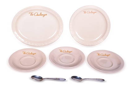
Seven Pieces of Union Pacific Railroad China and Silver - Challenger Plates, Saucers, and DemitasseRail & Road Auctions4.6(165)See Sold PriceMar 07, 2024
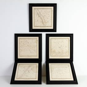
Set of Five Astronomical Zodiac Maps of the Stars by Baldwin & Gradock 1830Passion For Antiques4(24)See Sold PriceFeb 25, 2024
ALIEN3 (1992) - Hand-drawn Bait and Chase Five Page Storyboard and MapPropstore4.3(7)See Sold PriceMar 13, 2024
Operation Torch Nov 1942-May 1943. World War 2. Western Mediterranean 1966 mapJasper524.5(9.9k)See Sold PriceFeb 28, 2024