MATTHEWS c1856 Map Of Upper Canada Ontario Indian Land Agency Divisions Scarce!Luis Porretta Fine Arts4.3(10)See Sold PriceMar 02, 2024
DEVINE c1856 Dr Salters Map Of Lake Huron Ontario Indian Lands etc. No. 7 ScarceLuis Porretta Fine Arts4.3(10)See Sold PriceMar 02, 2024
DUNLEVIE c1856 Map Counties Of Gaspe & Bonaventure Quebec Canada SCARCE! #1Luis Porretta Fine Arts4.3(10)See Sold PriceMar 02, 2024
DUNLEVIE c1856 Map Counties Of Gaspe & Bonaventure Quebec Canada SCARCE! #2Luis Porretta Fine Arts4.3(10)See Sold PriceMar 02, 2024
Map UNITED COUNTIES LEEDS & GRENVILLE by Walling 1861 Rare Canada Map 5ft x 5ftLuis Porretta Fine Arts4.3(10)See Sold PriceMar 02, 2024
Ambroise TARDIEU c1822 Map Venice Napoleon Italian Campaign 17" x 11"Luis Porretta Fine Arts4.3(10)See Sold PriceMar 02, 2024
SoldFaden Map of the Battle of Long Island, Fifth and Last StateFADEN, William (1749-1836). A Plan of New York Island, with part of Long Island, Staten Island & East New Jersey. Engraved map with original hand color. London: William Faden, October 19th, 1776. 30 1See Sold Price
Faden Map - Battle of Long IslandFADEN, William (1749-1836). A Plan of New York Island, with part of Long Island, Staten Island & East New Jersey. Engraved map with original hand color. London: William Faden, October 19th, 1776. 30 1See Sold Price
Faden Revoltionary War battle mapFaden, William (1749-1836). A plan of New York Island, with part of Long Island, Staten Island & East New Jersey. Engraved map with original hand color in part above letterpress text in 4 columns. LonSee Sold Price
Faden Plan of New York Island during the Revolutionary War, First StateFADEN, William (1749 - 1836). A plan of New York Island with part of Long Island, Staten Island, and East New Jersey... Engraved map with original hand color. London: Faden, Oct. 19, 1776. 20 3/4" x 1See Sold Price
NEW ENGLAND STATES AND LONG ISLAND 1878 MAPSize: 18 X 13 inches approx. Unframed. Printed 1878. Centerfold as issued.See Sold Price
NEW ENGLAND STATES AND LONG ISLAND 1878 MAPSize: 18 X 13 inches approx. Unframed. Printed 1878. Centerfold as issued.See Sold Price
NEW ENGLAND STATES AND LONG ISLAND 1878 MAPSize: 18 X 13 inches approx. Unframed. Printed 1878. Centerfold as issued.See Sold Price
NEW ENGLAND STATES AND LONG ISLAND 1878 MAPSize: 18 X 13 inches approx. Unframed. Printed 1878. Centerfold as issued.See Sold Price
NEW ENGLAND STATES AND LONG ISLAND 1878 MAPSize: 18 X 13 inches approx. Unframed. Printed 1878. Centerfold as issued.See Sold Price
SoldFaden Map of New York, 1776FADEN, William (1749-1836). A Plan of New York Island, with part of Long Island, Staten Island & East New Jersey. Engraved map. London: William Faden, October 19th, 1776. 26 3/4" x 21 3/4" sheet, 39"See Sold Price
Long Island Sound (Western Sheet)/Continuation to NewTitle/Content of Map: Long Island Sound (Western Sheet)/Continuation to New York Cartographer: Hassler, F. R./E. Blunt/J. Ferguson/C. M. Eakin, et al. Date: 1889-08-26 Publisher: United States Coast &See Sold Price
SoldLOT ASSORTED BOOK PLATE COASTAL MAPS OF UNITED STATESLOT ASSORTED BOOK PLATE COASTAL MAPS OF UNITED STATES INCLUDING LONG ISLAND SOUND, BOSTON HARBOR, ETC 19TH CENTURYSee Sold Price
The country illustrating the engagement in Long Island.TITLE/CONTENT OF MAP: 'Sketch of the country illustrating the late engagement in Long Island' The map was printed to illustrate the theatre of the Battle of Long Island, also known as the Battle of BrSee Sold Price
SoldELEVEN MAPS. - unframed.ELEVEN MAPS. United States of America. John Melish, published by Carey & Son, 1820 (17 1/2 x 22) Map of Long Island. De Beers, NY, c. 1840, a fold out map in brown buckram covers (13 x 50 in.). TerraSee Sold Price
SoldMAP OF NEW YORK, THOMAS KITCHIN, 1756A MAP OF THE EASTERN PART OF THE PROVINCE OF NEW YORK, WITH PART OF NEW JERSEY, showing Pennsylvania, New York state, Long Island, Connecticut and New Hampshire, with Lake OntarioSee Sold Price
SoldNew York State Geology 19th Century BookNatural History of New York. Geology. William W. Mather. New York: 1843. Numerous illustrated plates and maps, but lacking large Long Island map.See Sold Price
SoldWilliam Damerum, Map of the Southern Part of the StateDAMERUM, William. Map of the Southern Part of the State of New York, including Long Island, the South, the State of Connecticut, part of the State of New Jersey and Islands adjacent. New York: Wm. DamSee Sold Price
Map of New York & Long Island, 1868Original engraving from Johnson's Atlas of the World, 1868. Map includes vignette of Long Island & cities, towns and territories. Dimensions: 18" x 26". No Reserve This item ships from Ocean View, DE.See Sold Price
Map of New York & Long Island, 1868Original engraving from Johnson's Atlas of the World, 1868. Map includes vignette of Long Island & cities, towns and territories. Dimensions: 18" x 26". Shipping Domestic: Shipping rates are determindSee Sold Price
Map of New York & Long Island, 1868Original engraving from Johnson's Atlas of the World, 1868. Map includes vignette of Long Island & cities, towns and territories. Dimensions: 18" x 26". No Reserve Buyer pays shipping - ships from OceSee Sold Price
Map of New York & Long Island, 1868Original engraving from Johnson's Atlas of the World, 1868. Map includes vignette of Long Island & cities, towns and territories. Dimensions: 18" x 26". This item ships from Ocean View, DE.See Sold Price
Map of New York & Long Island, 1868Original engraving from Johnson's Atlas of the World, 1868. Map includes vignette of Long Island & cities, towns and territories. Dimensions: 18" x 26". No Reserve Buyer pays shipping. This item shipsSee Sold Price
1859 SURVEY MAP OF HEMPSTEAD HARBOR, LONG ISLAND, NEWScarce and detailed engraved map of Hempstead Harbor Long Island published in 1859 by the "Survey of the Coast of the United States" 1:20 000 scale. The plate measures approx. 16.25 x 18 in.See Sold Price
Nautical Map / Sea Chart, #1212 Long Island Sound -Description: Nautical Map / Sea Chart, United States East Coast, Connecticut - New York, Long Island Sound East, New London Harbor, Long Island Sound Eastern Part, 8th edition Jul/29/63 stamped w/ NOTSee Sold Price
Rock Island RR Iowa and Minnesota Lakes Country Brochure-1926JM Hobby Supply and Railroad Artifact Auctions4.4(127)See Sold PriceFeb 24, 2024
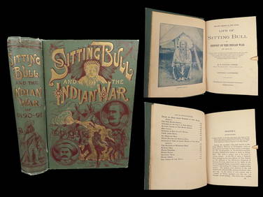
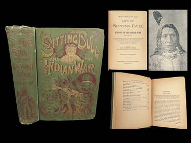
1891 Sitting Bull 1st ed Life Native American Sioux Indians DAKOTA Ghost DanceSchilb Antiquarian Rare Books4.8(431)See Sold PriceMar 10, 2024
EARLY 18TH C. DUTCH CHART OF PACIFIC OCEAN BY FREDERIK DE WIT (1629-1706) WITH CALIFORNIA AS ANThomaston Place Auction Galleries4.4(394)See Sold PriceFeb 24, 2024
No Reserve Early 20th century French / Flemish Design Tapestry 6 ft 2 in x 4 ft 9 in (1.87 m x 1.44Nazmiyal Auctions4.4(36)See Sold PriceFeb 25, 2024
No Reserve Early 20th Century French Unicorn Design Tapestry 5 ft 9 in x 4 ft 8 in (1.75 m x 1.42 m)Nazmiyal Auctions4.4(36)See Sold PriceFeb 25, 2024
CHART "LONG ISLAND SOUND FROM NEW YORK TO MONTOCK POINT ..." New York, 1830 21" x 77" sight. FramedEldred's4.7(423)See Sold PriceFeb 27, 2024
CHART "SOUTHERN COAST OF LONG ISLAND FROM MONTAUK POINT TO EAST HAMPTON" Circa 1877 11.25" x 22.75"Eldred's4.7(423)See Sold PriceFeb 27, 2024
Group of Ten Railroad Photographs, Maps, and Prints - New Jersey, Long Island, and New YorkRail & Road Auctions4.6(165)See Sold PriceMar 07, 2024
1891 DAKOTA Indians 1st ed Life Sitting Bull Native American Sioux Ghost DanceSchilb Antiquarian Rare Books4.8(431)See Sold PriceMar 31, 2024
Iron Mountain Of Long Island Sound Litho J GleasonThe Benefit Shop Foundation Inc.4.3(3k)See Sold PriceMar 06, 2024
A "Red Book" of the Greatest War of History 1914North American Artifact Auctions4.7(201)See Sold PriceApr 20, 2024
[CHICAGO]. Rare Pre-Fire Illinois Map: “Blanchard’s Map of ...Potter & Potter Auctions4.6(550)See Sold PriceMar 07, 2024
Roy Lichtenstein "American Indian Theme V (C. 164)" 1980 Woodcut on Handmade Suzuki Paper, signed anWhite Knight Auction, Inc4.7(259)See Sold PriceFeb 25, 2024
Hist. of Indian wars of the Far West - Massacres of the MountainsJasper524.5(9.9k)See Sold PriceFeb 27, 2024
Zuni Pueblo, Native American Polychrome VaseWorld Auction Gallery LLC4.7(267)See Sold PriceMar 10, 2024
Mauritz Frederik Hendrick De Haas (1832 - 1895) New York/ HollandCutler Bay Auctions4.4(181)See Sold PriceFeb 29, 2024
Map of United States of North America, 1785Antiques Online Auctions4.6(419)See Sold PriceMar 14, 2024


![[CHICAGO]. Rare Pre-Fire Illinois Map: “Blanchard’s Map of ... (1 of 2)](https://p1.liveauctioneers.com/928/318880/171361260_1_x.jpg?height=282&quality=70&version=1707501302)