SoldFacsimile of Mitchell map of American ColoniesHeading: Author: Mitchell, John Title: A Map of the British Colonies in North America with the Roads, Distances, Limits and Extent of the Settlements, Humbly Inscribed to the Right Honourable The EarSee Sold Price
S. Augustus Mitchell map of American and Mexico CoS. Augustus Mitchell map of American and Mexico Connecticut (circa 1839) "No. 5 Map of the United States, No. 6 Map of Mexico and Guatemala" hand-colored engraving. (Good condition, trimmed) paper sizSee Sold Price
SoldJanssonius Map of American ColoniesJANSSONIUS, Johannes (1588-1664). Nova Anglia Novum Belgium et Virginia. Engraved map with original hand color. Amsterdam, 1637 (First State, English Text). 19 1/2 x 23 1/4 inches sheet, 31 x 34 incheSee Sold Price
Moll Map of American ColoniesMOLL, Herman (c.1654-1732). A New and Exact Map of the Dominions of the King of Great Britain on ye Continent of North America...Engraved Map with original hand color in part. Sold By H. Moll over agaSee Sold Price
SoldHomann map of American colonies c.1740Title: Dominia Anglorum in America Septentrionali/ Sie Gros-Brittanische Colonie Lænder in Nord-America... Author: Homann Heirs Description: 4 copper-engraved maps on 1 sheet, hand-colored. 49.5x54.4See Sold Price
SoldHomann Map of American ColoniesNova Anglia. Johann Baptiste Homann (1664-1724). Engraved map with original hand color. Nuremberg, c. 1716. 20 1/2 x 24 inches sheet. The map shows that as the number of English settlements increasedSee Sold Price
Homann map of American colonies c.1740Title: Dominia Anglorum in America Septentrionali/ Sie Gros-Brittanische Colonie Lænder in Nord-America... Author: Homann Heirs Description: 4 copper-engraved maps on 1 sheet, hand-colored. 49.5x54.4See Sold Price
VAUGONDY MAP OF AMERICAN COLONIES. N/R.VAUGONDY MAP OF AMERICAN COLONIES. N/R. Dated 1765. Paper. Showing the colonies from Nouvelle Angleterre (New England) to the Carolinas. Size: 20 1/2" h., 25 1/2" w., framed 28" h., 33" w. Condition:See Sold Price
SoldMap of the American Colonies from December, 1754This map is titled 'An Accurate Map of the English Colonies in North America bordering on the River Ohio', a scarce early map of the British Colonies in North America and one of the earliest maps to aSee Sold Price
SoldBowen maps of the American coloniesHeading: Author: Bowen, Thomas Title: A Map of the British and French Settlements in North America... Place Published: London Publisher: Date Published: 1759 Description: TSee Sold Price
Homann map of British American colonies 1756Title: America Septentrionalis a Domino d'Anville in Galliis Edita Nunc in Anglia Coloniis in Interiorem Virginiam Deductis nec non Fluvii Ohio Cursu... Author: Homann Heirs Description: Copper-engravSee Sold Price
SoldHomann map of British American colonies 1756Title: America Septentrionalis a Domino d'Anville in Galliis Edita Nunc in Anglia Coloniis in Interiorem Virginiam Deductis nec non Fluvii Ohio Cursu... Author: Homann Heirs Description: Copper-engravSee Sold Price
SoldHomann map of British American colonies 1756Heading: Author: Homann Heirs Title: America Septentrionalis a Domino d'Anville in Galliis Edita Nunc in Anglia Coloniis in Interiorem Virginiam Deductis nec non Fluvii Ohio Cursu... Place Published:See Sold Price
SoldMitchell Map of the American RepublicMITCHELL, S. Augustus (1790-1868).Mitchell's National Map of the American Republic, or United States of North America.Lithographed map with original hand color.Philadelphia: Mitchell, 1850. 49 1/4" xSee Sold Price
Holland & Pownall Map of the American ColoniesHOLLAND, Major Samuel (1728-1801) & POWNALL, Thomas (1722-1805). The Provinces of New York and New Jersey; with Part of Pensilvania, and the Province of Quebec. Engraved map with orignal hand color. LSee Sold Price
SoldMorden: Antique Map of Florida & the Great Lakes, 16931693 map of Florida and the Great Lakes by Robert Morden. 5 x 5 inches. A very special map--one of the very earliest obtainable English maps of the American colonies. A Map of Florida and Ye Great LakSee Sold Price
SoldAntique 1846 Mitchel's Wall Map of American RepublicAntique 1846 Mitchell national map of American Republic. This map was published by Samuel Augustus Mitchell in 1846 in Philadelphia. Mitchell started his working life as a teacher, but was inspired toSee Sold Price
Sold3 pieces. Folding 19th-Century American Maps: Mit3 pieces. Folding 19th-Century American Maps: Mitchell, S. Augustus, pub. Mitchell's Traveller's Guide to the United States." Philadelphia, 1832. Fold. hand-colored map; tears along folds, a few celloSee Sold Price
SoldMorden: Antique Map of Florida & Great Lakes, 16931693 map of Florida and the Great Lakes by Robert Morden. Measures 5" x 5". One of the very earliest English maps of the American colonies. Titled "A Map of Florida and Ye Great Lakes of Canada." FullSee Sold Price
Sold1845 Augustus Mitchell National Map of the American1845 Augustus Mitchell National Map of the American Republic, on original rollers, 40 by 49 1/4 inchesSee Sold Price
Mitchell: Antique Map of the American Republic, 1843Map: Mitchell's National Map of the American Republic first ed. Date Printed: 1843 Cartographer: Mitchell, Samuel Augustus Size: 47 x 37 inches Original hand color with varnish Engraver: J.H. BrightlySee Sold Price
SoldMitchell: Antique Map of South American Countries, 1869Map: New Granada Venezuela Peru Ecuador Argentina Date Printed: 1869 Cartographer: Augustus S. Mitchell Material/Medium: Paper Size: 12 1/4" x 15 1/4" Hand colored engraved map. Printed in PhiladelphiSee Sold Price
A. MITCHELL - Map of Mexico, Central American and theA. MITCHELL Map of Mexico, Central American and the West Indies. Hand-colored lithoengraving. 1867. 13-1/4 x 21-1/8 inches.See Sold Price
Hand Tinted Photo - Tower of David - American ColonyLevy Auction House4.3(11)See Sold PriceFeb 27, 2024
Souvenir Photo Album of Jerusalem - American ColonyLevy Auction House4.3(11)See Sold PriceFeb 27, 2024
1849 Mitchell School ATLAS 24 MAPS America Holy Land France Africa Egypt AsiaSchilb Antiquarian Rare Books4.8(428)See Sold PriceMar 31, 2024
Charles Davis Mitchell (American 1887-1940) Graphite drawing Fashionable LadiesGlobal Auctions Company4.3(36)See Sold PriceMar 03, 2024
1860 The Spectator Joseph Addison 1710 John Dryden Alexander Pope 4v FINE SETSchilb Antiquarian Rare Books4.8(428)See Sold PriceMar 31, 2024
Joan Mitchell (American 1925-1992) attribMiami Auctions & Appraisals LLC 4.4(32)See Sold PriceFeb 26, 2024
Mitchell - Map of the City of Washington (Washington, DC)Trillium Antique Prints & Rare Books4.5(32)See Sold PriceFeb 24, 2024
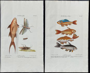
Edwards & Seligmann - 3 Fish EngravingsTrillium Antique Prints & Rare Books4.5(32)See Sold PriceFeb 24, 2024
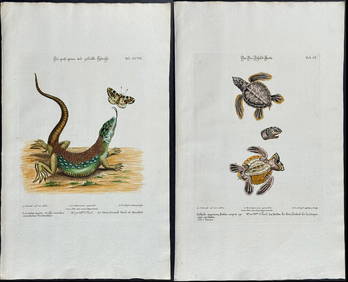
Edwards & Seligmann - 5 Engravings of Lizards, Snake, & Sea TurtleTrillium Antique Prints & Rare Books4.5(32)See Sold PriceFeb 24, 2024
Edwards & Seligmann - Pair of Diver or Loon EngravingsTrillium Antique Prints & Rare Books4.5(32)See Sold PriceFeb 24, 2024
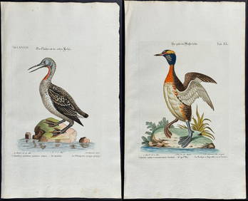
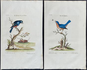
Edwards & Seligmann - 4 Bird EngravingsTrillium Antique Prints & Rare Books4.5(32)See Sold PriceFeb 24, 2024
COLONIES FRANÇAISES en AFRIQUE. Africa Sénégal Madagascar. LEVASSEUR c1850 mapJasper524.5(9.9k)See Sold PriceFeb 28, 2024
A GROUP OF TWO EARLY BLACK AND WHITE HOLY LAND PHOTOGRAPHS BY AMERICAN COLONY PHOTOGRAPHERS.J. Greenstein & Co., Inc.4.2(55)See Sold PriceApr 16, 2024