Sold[EUROPA] - ARROWSMITH, Aaron - Nouvelle Carte[EUROPA] - ARROWSMITH, Aaron - Nouvelle Carte Geographique et des postes de L'Europe - Neueste Post und General karte von Europa. Vienna: Artaria, 1807. A fine large format map illustrating Europe durSee Sold Price
Europa mit Mittelmeer (Jaillot): Ports de l'Europe- mit Mittelmeer und Nordafrika (Seekarte). Nouvelle Carte Marine de tous les Ports de l'Europe sur l'Ocean et sur la Mediterranée. Kupferstich mit großer dekorativer Rollwerk-Kartusche,See Sold Price
Sold[atlases] Arrowsmith, 1817Arrowsmith Aaron, Nouvel atlas universel-portatif de géographie ancienne et moderne contenant 39 cartes... Paris: Hyacinthe Langlois, 1817. In-4° (mm 340x250). 1 frontespizio inciso, 1 cartaSee Sold Price
SoldRARE EARLY 19TH C ATLAS - Arrowsmith, Aaron; 'A NewRARE EARLY 19TH C ATLAS - Arrowsmith, Aaron; 'A New General Atlas, Constructed from the latest Authorities, by A. Arrowsmith, Hydrographer to the Prince Regent, Exhibiting the Boundaries and DivisionsSee Sold Price
Chatelain: Nouvelle Carte D'Angleterre, 1719Map: Nouvelle Carte D'Angleterre, D'Ecosse, et D'Irlande… Maker/Publisher: Chatelain, Henri Abraham Date: 1719 Medium: Copperplate engraving Description: This attractive map shows the British IslesSee Sold Price
SoldArrowsmith, Aaron 1825 Rare World Hemisphere Map"World on Globular Projection" Steel Engraved Map Published 1825, London for "Outlines Of The World" by Aaron Arrowsmith. Rare. Outline hand color. Paper Size: 15 x 10.5 inch (37 x 27cm) Top margin slSee Sold Price
Sold1737 Nouvelle carte particuliere de l'Amerique by1737 Nouvelle carte particuliere de l'Amerique by Covens & Mortier, NE quadrant, 23 by 21 inches, small repair in top right corner,See Sold Price
SoldJacques Nicolas Bellin (1703-1772), "Nouvelle Carte desJacques Nicolas Bellin (1703-1772), "Nouvelle Carte des Decouvertes Faites par des Vaisee aux Russiens aux Cotes in connues del Amerique Septentrionales Avec les Pais Adiacents," 1758, H. - 10 3/4 in.See Sold Price
SoldHenri Abraham Chatelain (1684-1783), "Nouvelle Carte deHenri Abraham Chatelain (1684-1783), "Nouvelle Carte de l'Amerique Septentrionale Dressee sur Les Plus Nouvelles Observations," 1710, H. - 19 in., W. - 24 in.See Sold Price
Chatelain: Nouvelle Carte de l’Ile de Ceylon, 1719Map: Nouvelle Carte de l’Ile de Ceylon Cartographer: Chatelain Place & Date: Amsterdam / 1719 Size: 17 1/4" x 15 1/4" Condition: b&w A highly detailed map of the island of Ceylan, today's Sri Lanka,See Sold Price
Sold* ARROWSMITH, Aaron (1750-1823) and Samuel LEWIS* ARROWSMITH, Aaron (1750-1823) and Samuel LEWIS (d.1862). A New and Elegant General Atlas. Boston: Thomas & Andrews, May 1812. 4to (266 x 225 mm). 64 engraved maps (2 folding), including a duplicateSee Sold Price
SoldAlps.- Arrowsmith (Aaron) Map of the Alpine Country inAlps.- Arrowsmith (Aaron) Map of the Alpine Country in the South of Europe, showing from Florence to Regensburg, and Geneva across to Vienna, with large vignette of the village of Chamouny by Webber iSee Sold Price
SoldAfrica.- Arrowsmith (Aaron) Africa, large folding mapAfrica.- Arrowsmith (Aaron) Africa, large folding map of the continent, with decorative allegorical title cartouche lower left with lions, elephants and Egyptian artefacts, and dedication upper right,See Sold Price
SoldPyrenees.- Arrowsmith (Aaron) A Map of the Pyrenees andPyrenees.- Arrowsmith (Aaron) A Map of the Pyrenees and the Adjacent Provinces by Roussel, and Blottiere with additions from Torfiño, and Lopez, map of the Pyrenees and envrions, orientated withSee Sold Price
SoldNouvelle Carte de La Suisse les trieze cantons. FADEN.TITLE/CONTENT OF MAP: 'Nouvelle Carte de La Suisse dans laquelle sont exactement distingués les trieze cantons, leurs alliés, et leurs sujets' The top image on the right hand side shows the entire mSee Sold Price
Sold1718 Chatelain Map of Africa -- Nouvelle Carte deTitle: 1718 Chatelain Map of Africa -- Nouvelle Carte de l'Afrique avec des Remarques et des Tables pour Trouver sans Peine les Differents Peuples de cette Partie du Monde… Cartographer: H ChatelainSee Sold Price
SoldNicolas Visscher, "Nouvelle Carte de la Mer Noire et deNicolas Visscher, "Nouvelle Carte de la Mer Noire et de Canal de Constantinople", Amsterdam, 1680, 20-1/4" x 24" sight, 29" x 32" overall, center crease, discoloration and light foxingSee Sold Price
1680 Nouvelle Carte marine croissante en degres d’uneThis strikingly beautiful sea chart of the northern coast of France, including most of the Normandie peninsula, shows detailed information for navigational purposes. Rhumb lines radiate from a large nSee Sold Price
1680 Nouvelle Carte marine croissante en degres d’uneThis strikingly beautiful sea chart of the northern coast of France, including most of the Normandie peninsula, shows detailed information for navigational purposes. Rhumb lines radiate from a large nSee Sold Price
Sold1720 Chatelain Map of Italy -- Nouvelle Carte De L'EtatTitle: 1720 Chatelain Map of Italy -- Nouvelle Carte De L'Etat Present De L'Italie Pur Parvenir par Une Methode Nouvelle A La Connoissance De La Geographie Et De L'Histoire. . . Cartographer: H ChatelSee Sold Price
1714 Chatelain Map of Sri Lanka -- Nouvelle Carte deReserve Reduced! Title/Content of Map: 1714 Chatelain Map of Sri Lanka -- Nouvelle Carte de l'Ile de Ceylon, avec des Remarques Historiques Date: 1714 c., Amsterdam Cartographer: H Chatelain Size: 15.See Sold Price
SoldArrowsmith (Aaron) - Map of Europe Drawn from all thewall map with inset oval portrait of the dedicatee, Sir Joseph Banks, lower left, and title vignette of Iron Bridge, lower right, engraved map with hand-colouring, 1270 x 1470mm., dissected and linen-See Sold Price
SoldNouvelle Carte des Isles Carolines' Islands. MicronesiaTITLE/CONTENT OF MAP: 'Nouvelles Carte des Isles Carolines [New map of the Caroline Islands]' DATE PRINTED: 1761 IMAGE SIZE: Approx 21.5 x 40.5cm, 8.5 x 16 inches (Large); Please note that this is a fSee Sold Price
SoldNouvelle Carte du Royaume de BengaleBy Jacques Nicolas Bellin, Paris, 1764[In Le Petit Atlas Maritime, vol. III]27.5 cm x 34.5 cm (H x W; all measurements are approximate)Original outline color (turquoise) to coast and rivers.*WatermarkSee Sold Price
Harry Aaron Kernoff (Irish,1900-1974) oil paintingBroward Auction Gallery4.8(265)See Sold PriceMar 17, 2024
Gothic Revival Stained Glass Window of AaronSchmidt's Antiques Inc. Since 19114.8(425)See Sold PriceMar 02, 2024
Aaron Fink oil on canvas, titled "Red Spoon", dated 1985. Signed and dated on verso. Label on versoNeely Auction4.5(222)See Sold PriceFeb 25, 2024
Autographed 1964 Topps Hank Aaron and Willie MaysPast to Present Auctions4.3(7)See Sold PriceMar 02, 2024
Autographed 1963 Topps Hank Aaron and Ernie BanksPast to Present Auctions4.3(7)See Sold PriceMar 02, 2024
Jacques Lipchitz (American/French, 1891-1973) - Variation of the Rape of Europa GFreeman's | Hindman4.5(158)See Sold PriceFeb 27, 2024
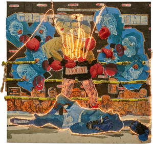
Aaron Fowler (b. 1988), "Pushers and Users" mixed media on garage doorsJohn Moran Auctioneers, Inc.4.7(450)See Sold PriceFeb 27, 2024
Aaron Fowler (b. 1988), Lights Out, Mixed media on two joined pieces of particle board installation,John Moran Auctioneers, Inc.4.7(450)See Sold PriceFeb 27, 2024
[BASEBALL CARTE DE VISITE ]. Carte de Visite Photograph of ...Potter & Potter Auctions4.6(538)See Sold PriceMar 07, 2024
[BASEBALL CARTE DE VISITE]. Carte de Visite Photograph of a...Potter & Potter Auctions4.6(538)See Sold PriceMar 07, 2024
[BASEBALL CARTE DE VISITE]. Carte de Visite Photograph of F...Potter & Potter Auctions4.6(538)See Sold PriceMar 07, 2024
Arrowsmith & Lewis - Map of PolynesiaTrillium Antique Prints & Rare Books4.5(28)See Sold PriceFeb 24, 2024
Arrowsmith & Lewis - Map of North AmericaTrillium Antique Prints & Rare Books4.5(28)See Sold PriceFeb 24, 2024
Arrowsmith & Lewis - Map of the World on Mercator's ProjectionTrillium Antique Prints & Rare Books4.5(28)See Sold PriceFeb 24, 2024
Arrowsmith & Lewis - Map of LouisianaTrillium Antique Prints & Rare Books4.5(28)See Sold PriceFeb 24, 2024
Arrowsmith & Lewis - Map of the United StatesTrillium Antique Prints & Rare Books4.5(28)See Sold PriceFeb 24, 2024
1758 MAP PARTIE DE LA MER GLACIALE contenants La Nouvelle Zemble RUSSIA antiqueJasper524.5(9.7k)See Sold PriceFeb 27, 2024
![[EUROPA] - ARROWSMITH, Aaron - Nouvelle Carte First Image](https://p1.liveauctioneers.com/3662/175274/88222556_1_x.jpg?height=282&quality=95&version=1597918246&width=282)
![[EUROPA] - ARROWSMITH, Aaron - Nouvelle Carte (1 of 1)](https://p1.liveauctioneers.com/3662/175274/88222556_1_x.jpg?height=282&quality=70&version=1597918246)
![[EUROPA] - ARROWSMITH, Aaron - Nouvelle Carte First Image](https://p1.liveauctioneers.com/3662/175274/88222556_1_x.jpg?height=282&quality=1&version=1597918246&width=282)

![[atlases] Arrowsmith, 1817 (1 of 3)](https://p1.liveauctioneers.com/1306/149409/75467403_1_x.jpg?height=282&quality=70&version=1567670708)


![[BASEBALL CARTE DE VISITE ]. Carte de Visite Photograph of ... (1 of 2)](https://p1.liveauctioneers.com/928/318880/171361404_1_x.jpg?height=282&quality=70&version=1707501302)
![[BASEBALL CARTE DE VISITE]. Carte de Visite Photograph of a... (1 of 2)](https://p1.liveauctioneers.com/928/318880/171361405_1_x.jpg?height=282&quality=70&version=1707501302)
![[BASEBALL CARTE DE VISITE]. Carte de Visite Photograph of F... (1 of 2)](https://p1.liveauctioneers.com/928/318880/171361408_1_x.jpg?height=282&quality=70&version=1707501302)


