ATLAS of ANTIENT GEOGRAPHY by SAMUEL BUTLER 1843John McInnis Auctioneers,LLC4.6(502)See Sold PriceFeb 24, 2024
18TH C. ANTIQUE MAP: FRENCH & INDIAN WAR, FRAMEDThomaston Place Auction Galleries4.4(386)See Sold PriceFeb 24, 2024
Rand McNally Railroad Map Cabinet w/ 21 Railroad MapsRail & Road Auctions4.6(165)See Sold PriceMar 08, 2024
Keith Haring - Ink on New York Map, Best Buddies, Inscribed, Signed, and DatedSapphire Auction Gallery4(67)See Sold PriceMar 02, 2024
LATE 17TH C. FRENCH MAP OF THE NEW WORLD BY ALEXIS-HUBERT JAILLOT (1632-1712)Thomaston Place Auction Galleries4.4(386)See Sold PriceFeb 24, 2024
Central Railroad of New Jersey Map of Sandy Hook Route-ca. 1903JM Hobby Supply and Railroad Artifact Auctions4.4(126)See Sold PriceFeb 24, 2024
Lot of Six Mixed Atlas Box Cars-HO Scale-New in BoxJM Hobby Supply and Railroad Artifact Auctions4.4(126)See Sold PriceFeb 25, 2024
Rand McNally/Santa Fe Railroad Map of Iowa-1912JM Hobby Supply and Railroad Artifact Auctions4.4(126)See Sold PriceFeb 24, 2024
NICOLAES VISSCHER (NETHERLANDS, 1618-1709) MAP OF THE NEW WORLDThomaston Place Auction Galleries4.4(386)See Sold PriceFeb 24, 2024
17TH C. WORLD MAP BY NICOLAES VISSCHER (NETHERLANDS, 1618-1709)Thomaston Place Auction Galleries4.4(386)See Sold PriceFeb 24, 2024
Lot of Six Mixed Atlas Cabooses-HO Scale-New in BoxJM Hobby Supply and Railroad Artifact Auctions4.4(126)See Sold PriceFeb 25, 2024
Ethnographic map of Europe. Breton Basque Flemish Languages. THE TIMES 1900TITLE/CONTENT OF MAP: 'Ethnographic map of Europe' DATE PRINTED: 1900 IMAGE SIZE: Approx 25.0 x 38.0cm, 9.75 x 15 inches (Large) TYPE: Antique colour atlas map CONDITION: Good; suitable for framing. PSee Sold Price
Ethnographic map of Europe. Breton Basque Flemish Languages. THE TIMES 1900TITLE/CONTENT OF MAP: 'Ethnographic map of Europe' DATE PRINTED: 1900 IMAGE SIZE: Approx 25.0 x 38.0cm, 9.75 x 15 inches (Large) TYPE: Antique colour atlas map CONDITION: Good; suitable for framing. PSee Sold Price
Europe Ethnographic map. Breton Basque Flemish Sudtyrol Languages. TIMES 1895TITLE/CONTENT OF MAP: 'Ethnographic map of Europe' DATE PRINTED: 1895 IMAGE SIZE: Approx 25.0 x 38.0cm, 9.75 x 15 inches (Large) TYPE: Antique colour atlas map CONDITION: Good; suitable for framing. PSee Sold Price
Europe Ethnographic map. Breton Basque Flemish Sudtyrol Languages. TIMES 1895TITLE/CONTENT OF MAP: 'Vindelicia, Noricum, Rhaetia, Pannonia et Illyricum vel Regiones intra Danubium, Savum et Drinum f1. Hadriaticum Mare et Padum f1. sitae' DATE PRINTED: 1828 IMAGE SIZE: Approx 2See Sold Price
Europe (General map). Political. THE TIMES 1900 old antique plan chartTITLE/CONTENT OF MAP: 'Europe (General map)' DATE PRINTED: 1900 IMAGE SIZE: Approx 40.5 x 52.0cm, 15.75 x 20.5 inches (Large); Please note that this is a folding map. TYPE: Antique colour atlas map COSee Sold Price
Europe (General map). Political. THE TIMES 1900 old antique plan chartTITLE/CONTENT OF MAP: 'Europe (General map)' DATE PRINTED: 1900 IMAGE SIZE: Approx 40.5 x 52.0cm, 15.75 x 20.5 inches (Large); Please note that this is a folding map. TYPE: Antique colour atlas map COSee Sold Price
The Caucasus. Georgia Armenia Azerbaijan Russia Turkey Iran. THE TIMES 1900 mapTITLE/CONTENT OF MAP: 'Europe' Shows all the distinct powers of Europe of the day. Poland features prominently DATE PRINTED: 1817 IMAGE SIZE: Approx 28.5 x 24.0cm, 11.25 x 9.5 inches (Large); Please nSee Sold Price
SoldThe Times 1895 Lot of 8 Maps of EuropeIncl Ethnographic Map of Europe, Holland, Belgium and Luxemburg, Denmark, Alsace/Bavaria, Ethnographic Map of Austria-Hungary, Hungary, and Norway/Sweden. Lithograph Maps Published 1895, London for "TSee Sold Price
SoldThe Times 1895 Lot of 7 Maps of EuropeIncl Constantinople, Religions of Europe, Ethnographic Map of the Balkan Peninsula, Greece, Southern Scandinavia, Mediterranean Sea, and General Map of the Alps. Lithograph Maps Published 1895, LondonSee Sold Price
The Times 1895 Lot of 7 Maps of EuropeIncl Constantinople, Religions of Europe, Ethnographic Map of the Balkan Peninsula, Greece, Southern Scandinavia, Mediterranean Sea, and General Map of the Alps. Lithograph Maps Published 1895, LondonSee Sold Price
Sold19th century map depicting Europe in 190019th century map depicting Europe in 1900; in 1100; in the Time of Charles V; and in 1789, published by John Thompson & Co., Edinburgh 1823, 20" x 25"See Sold Price
SoldJohn Speed 17th C Map Europe And The Chief CitiesJohn Speed (English, c.1551–1629). A hand colored 17th century map of Europe titled EUROP, AND THE CHIEFE CITIES, featuring description on verso. Measures 16 in. x 21 in. (sight), 20 1/2 in. x 25 1/See Sold Price
Sold1850s Dufour ATLAS 42 HUGE MAPS Europe ENORMOUS & RARE Geography Cartography1850s Dufour ATLAS 42 HUGE MAPS Europe ENORMOUS & RARE Geography Cartography Adolphe Dufour was a 19th-century French cartographer and map maker known for his highly detailed maps of European cities aSee Sold Price
Blaeu: Antique Map of Europe, 1650Title/Content of Map: Europe by Blaeu Date Printed: c1650 Cartographer: W. Blaeu Material/Medium: Paper Size: 19" x 24" Hand colored engraved Map. French text on verso. Magnificent example of Dutch goSee Sold Price
Munster: Antique Woodcut Map of Europe, 1588Title: Europa das ein Drittheil der Erde nach gelegenheit unserer zeit beschrieben...1588 Münster woodcut and letterpress map of Europe Map maker: Sebastian Münster, Cosmographia Place and Year: BasSee Sold Price
SoldOrtelius: Map of Europe, 1584Title: Europae Map maker: Abraham Ortelius Place and Year: Antwerp, 1584 Dimensions: 34.2 x 46 cm (13½ x 18¼ in) Technique: Copperplate engraving Coloring: Hand colored Condition Rating: VG,Some tonSee Sold Price
SoldBlaeu: Antique Map of Europe, 1650Title/Content of Map: Highly decorative Map by Blaeu Date Printed: c1650 Cartographer: W. Blaeu Material/Medium: Paper Size: 19" x 24" Hand colored engraved Map. French text on Verso. Magnificent examSee Sold Price
1743 Homann Map of Europe1743 Homann Map of Europe -- Europa Secundum Legitimas Projectionis Stereographicae Regulas et Juxta Recentissimas Observationes Aeque ac Relationes…. J. Homann, 1743 Nurnberg, An elegant map of EurSee Sold Price
SoldGrp: 3 Maps Eastern Europe Ukraine Romania BlaeuGroup of three maps of Eastern Europe. Includes one map of Walachia, Serbia, Bulgaria, and Romania by Willem Janszoon Blaeu (1571-1638); one map of Slovenia, Croatia, and Bosnia by Blaeu after GerarduSee Sold Price
Sold17th Century Hand Colored Map of EuropeBy J. Hondius, 1638. Very nicely hand tinted example having been well framed. Matt does not appear to be acid free but there is little evidence of burn. Good overall condition. The piece has an originSee Sold Price
SoldFramed Antique Map, EuropaFramed antique map of Europe. Plate marks visible. hand-colored. Hand-written information along verso Of frame. Map is set behind glass in wood frame in two-tone wood style frame. Measures approximateSee Sold Price
Carte Politique Et Itineraire De L'Europe...1807 map of Europe: “CARTE POLITIQUE ET ITINÉRAIRE DE L'EUROPE ET DE L'EMPIRE FRANCAIS EN 1807 “by Hyacinthe Langlois. Measurement approximate: 19” x 14.5”. Please note that this lot has a coSee Sold Price
Sold3 Antique & Vintage Victorian Lace DressesStep back in time, early 1900's, when soft, romantic Edwardian style dresses of gorgeous silk organza/ chiffon were worn. Ethereal white/ivory fabrics delicately hand embroidered mixed laces. Small siSee Sold Price
SoldAmerican Mahogany Map Chest, Circa 1900Two-part American mahogany map chest, with 8 drawers, circa 1900. [35 3/4" H x 48 3/4" W x 34 3/4" W]. Very worn, with scratches and dents; drawers are tight and need some shaving and lubricant.See Sold Price
Willy Gordon 21in Judaica Swedish Bronze 1945 WWII Flight with Torah Jewish Statue Stockholm SwedenHess Fine Auctions4.5(197)See Sold PriceMar 02, 2024
1937 Holland, Michigan, Tulip Time Map Guide, FramedLakeshore Event Center4.5(99)See Sold PriceMar 02, 2024
Antique Red Silk Robe, Possibly Roma People, Eastern Europe or Middle EastMaterial Culture4.6(765)See Sold PriceFeb 29, 2024
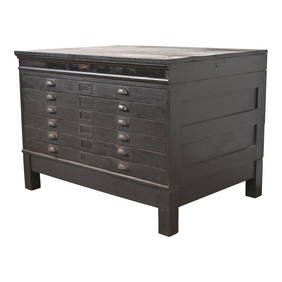
Antique Arts & Crafts Ebonized Oak Architect's Blueprint Flat File Cabinet, Circa 1900Liberty & 33rd Furniture Co.4.4(11)See Sold PriceFeb 27, 2024
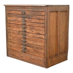
Antique Pine 12-Drawer Blueprint Flat File Cabinet by Hamilton, Circa 1900Liberty & 33rd Furniture Co.4.4(11)See Sold PriceFeb 27, 2024
Antique Arts & Crafts Oak Architect's Blueprint Flat File Cabinet, Circa 1900Liberty & 33rd Furniture Co.4.4(11)See Sold PriceFeb 27, 2024
Two (2) Antique 18th C. Copper Engraved Framed Maps - America & EuropeMagnusson Art Group4.5(46)See Sold PriceMar 14, 2024
Gilt Metal Ewer with Classical Decoration.Turner Auctions + Appraisals4.3(311)See Sold PriceMar 09, 2024
Carey, pub. 1796 - Map of KentuckyTrillium Antique Prints & Rare Books4.5(30)See Sold PriceFeb 24, 2024
Carey, pub. 1796 - Map of the Tennassee State formerly part of North Carolina (Tennessee)Trillium Antique Prints & Rare Books4.5(30)See Sold PriceFeb 24, 2024
De Jode, Rare, pub. 1593 - Map of the Middle East, Eastern Asia (Primae Partis Asiae accurataTrillium Antique Prints & Rare Books4.5(30)See Sold PriceFeb 24, 2024
Russian Enamel - Inkwell, Blotter, Spoon, & CandlestickArtemis Fine Arts4.8(1.4k)See Sold PriceFeb 26, 2024
MANSON CHARLES: (1934-2017)International Autograph Auctions Europe S.L.4.5(52)See Sold PriceMar 13, 2024