ATLAS of ANTIENT GEOGRAPHY by SAMUEL BUTLER 1843John McInnis Auctioneers,LLC4.6(502)See Sold PriceFeb 24, 2024
18TH C. ANTIQUE MAP: FRENCH & INDIAN WAR, FRAMEDThomaston Place Auction Galleries4.4(386)See Sold PriceFeb 24, 2024
Rand McNally Railroad Map Cabinet w/ 21 Railroad MapsRail & Road Auctions4.6(165)See Sold PriceMar 08, 2024
Keith Haring - Ink on New York Map, Best Buddies, Inscribed, Signed, and DatedSapphire Auction Gallery4(67)See Sold PriceMar 02, 2024
LATE 17TH C. FRENCH MAP OF THE NEW WORLD BY ALEXIS-HUBERT JAILLOT (1632-1712)Thomaston Place Auction Galleries4.4(386)See Sold PriceFeb 24, 2024
Central Railroad of New Jersey Map of Sandy Hook Route-ca. 1903JM Hobby Supply and Railroad Artifact Auctions4.4(126)See Sold PriceFeb 24, 2024
Lot of Six Mixed Atlas Box Cars-HO Scale-New in BoxJM Hobby Supply and Railroad Artifact Auctions4.4(126)See Sold PriceFeb 25, 2024
Rand McNally/Santa Fe Railroad Map of Iowa-1912JM Hobby Supply and Railroad Artifact Auctions4.4(126)See Sold PriceFeb 24, 2024
NICOLAES VISSCHER (NETHERLANDS, 1618-1709) MAP OF THE NEW WORLDThomaston Place Auction Galleries4.4(386)See Sold PriceFeb 24, 2024
17TH C. WORLD MAP BY NICOLAES VISSCHER (NETHERLANDS, 1618-1709)Thomaston Place Auction Galleries4.4(386)See Sold PriceFeb 24, 2024
Lot of Six Mixed Atlas Cabooses-HO Scale-New in BoxJM Hobby Supply and Railroad Artifact Auctions4.4(126)See Sold PriceFeb 25, 2024
SoldEnglish Map Sampler17 3/4" x 13 1/4" oval 19th century estimate 250/350 Shipping available within the Continental USA (excludes insurance) $50. International shippers are responsible for arranging 3rd party shipping.See Sold Price
SoldEnglish Map Sampler, Dated 1792.English Map Sampler by Mary Anne Roper, depicting various counties of Great Britain, dated 1792. (Approx. 16 1/2" x 13 1/2").See Sold Price
English Map Sampler, Dated 1812.English Map Sampler by Sarah Allcock. Oval form with a surrounding floral border depicting the different countries of Great Britain. Dated 1812. Framed (Approx. 19" x 16", overall: 24" x 21").See Sold Price
English Map Sampler.English Map Sampler by Sarah Allcock. Oval form with a surrounding floral border depicting the different counties of Great Britain. Dated 1812. Framed (Approx. 20" x 17", overall: 24" x 21").See Sold Price
SoldEnglish Needlework Map SamplerEnglish Needlework Map Sampler, early 19th c., "Accurate Map of England and Wales", 27 in. x 22 in., framedSee Sold Price
SoldMAP SAMPLER. English. First quarter 19th Century.MAP SAMPLER. English. First quarter 19th Century. Silk on wool. Signed Lydia Jeffs" and entitled "England and Wales" in a corner banner. The oval map, outlining the counties, towns and sea surroundingSee Sold Price
SoldA linen cross-stitch needlework map sampler, English,A linen cross-stitch needlework map sampler, English, 18th century worked by Katherine Skipp and dated 1787 55cm high x 46cm wide Provenance Witney Antiques, EnglandSee Sold Price
SoldEnglish silk on silk map sampler of Great BritaiEnglish silk on silk map sampler of Great Britain dated 1791, initialed EL, 20 1/2'' x 17 1/4''.See Sold Price
MAP SAMPLER. Probably late 18th-early 19th CenturyMAP SAMPLER. Probably late 18th-early 19th Century, English. Silk on linen. A Map Of Europe By Anne Arbbuth[mon]". "1760". Multicolored outlines of European countries, parts of the near east and northSee Sold Price
SoldThree Needlework Map SamplersLot 371 Three English Silk Needlework Maps of the British Isles Three English silk needlework maps of the British Isles, map of England & Wales By Mary Skinner 1803, Map of Ireland, Map of England,See Sold Price
Embroidery.- A Map of England and WalesEmbroidery.- A Map of England and Wales,map sampler by Susanna Morgan, Llanwern, Monmouthshire, title cartouche and script in the North Sea, compass in the English Channel, silk embroidered maSee Sold Price
Embroidery.- A Map of England and WalesEmbroidery.- A Map of England and Wales,map sampler by Susanna Morgan, Llanwern, Monmouthshire, title cartouche and script in the North Sea, compass in the English Channel, silk embroidered maSee Sold Price
SoldAn English Needlework Map, Height of first overall 21 1An English Needlework Map, of oval form, depicting England, together with a sampler, each framed. Height of first overall 21 1/2 inches.See Sold Price
SoldAn English Needlework Sampler, 1785, Height of fAn English Needlework Sampler, 1785, depicting a general map of England and Wales, by Martha Chittenden, framed. Height of frame 27 1/2 x width 23 1/2 inches. Property from the Estate of Dorothy RothsSee Sold Price
English 1833 Sampler of England and WalesLucy Skirkette (at Long Stratton 1883 – from Verso), Sampler on Silk of a Map of England and Wales, Mounted in a Decorative Gilt and Gesso Oval Frame, Measuring 19 Inches by 22 Inches. Made for ClarSee Sold Price
Sold18th Century Map of England & Wales - Hand Stitched18th Century Map of England & Wales - Hand Stitched Needlework | 18th Century Map of England & Wales | Rare English Needlework on Silk Sampler | Hand Stitched with Geographical Border | HousedSee Sold Price
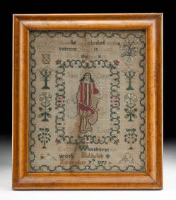
SoldHANDSEWN 18TH C. ENGLISH SAMPLER DATED 1716WITH ALPHABET, BIRDS, STAG, FRUIT & BARGELLO STITCHES, 12" X 11"See Sold Price
Sold18th C. English Map of Northeast US18th century English map, depicting New England and New York, by Thomas Basset and Richard Chiswell, 15" 1/8" h x 19 3/4" w (view), 22 1/4" h x 17 1/4" w (frame). Provenance: from a Massachusetts estaSee Sold Price
SoldSet Of Framed English Sampler PrintsSet of (9) English framed sampler prints. Largest frames 17" x 13".See Sold Price
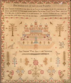
SoldAntique English Sampler Dated 1827Antique English Hand Stitched Sampler, Signed Mary Green aged 12 years, July 23rd, 1827. Beautiful intricate design features animals, the Crown, British Soldiers, trees and more. 23" x 23" framed, covSee Sold Price
SoldEnglish sampler, Jane Maynard, dated 1830, silk (wornEnglish sampler, Jane Maynard, dated 1830, silk (worn edges)See Sold Price
English Map of the World, 1850Map: World Published: 1850 in England Size: Folio, 14 x 21.3 inches As known to the ancients and sacred writers Please note that this lot has a reserve. When you leave a bid in advance of the auction,See Sold Price
SoldEARLY ENGLISH MAP OF LONDONEARLY ENGLISH MAP OF LONDON hand-colored, "Bowles's New Two-Sheet Plan of the Cities of London & Westminster; with the Borough of Southwick", 1797, printed for Bowles & Carver, London, title to upperSee Sold Price
SoldEnglish Sampler, 1833English Sampler, 1833multi-color silk worked on fine linen depicting a bouquet filled basket surmounted by a butterfly and bird, with pious verse and manor home; the sampler maker, Elizabeth Moore AllSee Sold Price
17TH C. ENGLISH LINEAR MAP BY OGILBY, FRAMEDThomaston Place Auction Galleries4.4(386)See Sold PriceFeb 24, 2024
PAUL SANDBY Copperplate Mezzotint Landscape 1738 Framed & SuperbLuis Porretta Fine Arts4.3(10)See Sold PriceMar 02, 2024
Portfolio of 15 County Maps by Robert Morden (English 1650-1703)Nadeau's Auction Gallery4.7(401)See Sold PriceFeb 24, 2024
1855 NOTES ON CENTRAL AMERICA by E. G. Squier antique w/ MAPSJasper524.5(9.8k)See Sold PriceFeb 27, 2024
1800 MUNGO PARK TRAVELS to AFRICA 2 VOLS w/ MAP antique in ENGLISHJasper524.5(9.8k)See Sold PriceFeb 27, 2024
WEST AFRICA Explorers' routes Senegal Ashanti. Mountains of Kong. SDUK 1857 mapJasper524.5(9.8k)See Sold PriceFeb 28, 2024
AFRICA. Map pre-dating much exploration. Mountains of Kong. SDUK 1851 oldJasper524.5(9.8k)See Sold PriceFeb 28, 2024
WEST AFRICA explorers' routes. Beaufort Gray Park Dochard Caillie. SDUK 1874 mapJasper524.5(9.8k)See Sold PriceFeb 28, 2024
WESTERN AFRICA.Kong Mountains.Caravan routes.Slave Coast.TALLIS/RAPKIN 1849 mapJasper524.5(9.8k)See Sold PriceFeb 28, 2024
WEST AFRICA I Explorers' routes Senegal Ashanti Ivory Gold Coast. SDUK 1851 mapJasper524.5(9.8k)See Sold PriceFeb 28, 2024
WESTERN AFRICA.Kong Mountains.Caravan routes.Slave Coast.TALLIS/RAPKIN 1851 mapJasper524.5(9.8k)See Sold PriceFeb 28, 2024
WEST AFRICA showing early explorers' routes & Mountains of Kong. SDUK 1844 mapJasper524.5(9.8k)See Sold PriceFeb 28, 2024
PRE COLONIAL WESTERN AFRICA. Shows Mountains of Kong. Tribes. WELLER 1863 mapJasper524.5(9.8k)See Sold PriceFeb 28, 2024
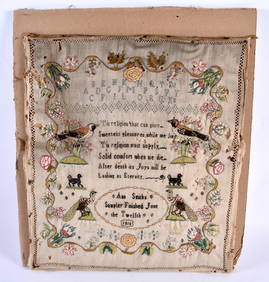
AN EARLY 19TH CENTURY ENGLISH EMBROIDERED SAMPLER by Ann Smith June 12th 1810. 34 cm square.Hannam's Auctioneers Ltd4.3(386)See Sold PriceFeb 27, 2024
A MID 18TH CENTURY ENGLISH EMBROIDERED SAMPLER dated 1738. 27 cm square.Hannam's Auctioneers Ltd4.3(386)See Sold PriceFeb 27, 2024
Late 18th century map of England and Wales sampler and two printsFellows4.3(159)See Sold PriceMar 05, 2024
John Senex Map of Louisiana & Mississippi RiverWillow Auction House4.5(283)See Sold PriceMar 14, 2024