ATLAS of ANTIENT GEOGRAPHY by SAMUEL BUTLER 1843John McInnis Auctioneers,LLC4.6(502)See Sold PriceFeb 24, 2024
18TH C. ANTIQUE MAP: FRENCH & INDIAN WAR, FRAMEDThomaston Place Auction Galleries4.4(386)See Sold PriceFeb 24, 2024
Rand McNally Railroad Map Cabinet w/ 21 Railroad MapsRail & Road Auctions4.6(165)See Sold PriceMar 08, 2024
Keith Haring - Ink on New York Map, Best Buddies, Inscribed, Signed, and DatedSapphire Auction Gallery4(67)See Sold PriceMar 02, 2024
LATE 17TH C. FRENCH MAP OF THE NEW WORLD BY ALEXIS-HUBERT JAILLOT (1632-1712)Thomaston Place Auction Galleries4.4(386)See Sold PriceFeb 24, 2024
Central Railroad of New Jersey Map of Sandy Hook Route-ca. 1903JM Hobby Supply and Railroad Artifact Auctions4.4(126)See Sold PriceFeb 24, 2024
Lot of Six Mixed Atlas Box Cars-HO Scale-New in BoxJM Hobby Supply and Railroad Artifact Auctions4.4(126)See Sold PriceFeb 25, 2024
Rand McNally/Santa Fe Railroad Map of Iowa-1912JM Hobby Supply and Railroad Artifact Auctions4.4(126)See Sold PriceFeb 24, 2024
NICOLAES VISSCHER (NETHERLANDS, 1618-1709) MAP OF THE NEW WORLDThomaston Place Auction Galleries4.4(386)See Sold PriceFeb 24, 2024
17TH C. WORLD MAP BY NICOLAES VISSCHER (NETHERLANDS, 1618-1709)Thomaston Place Auction Galleries4.4(386)See Sold PriceFeb 24, 2024
Lot of Six Mixed Atlas Cabooses-HO Scale-New in BoxJM Hobby Supply and Railroad Artifact Auctions4.4(126)See Sold PriceFeb 25, 2024
SoldEngland and Wales.- Luffman (John) A New Pocket AtlasEngland and Wales.- Luffman (John) A New Pocket Atlas and Geography of England and Wales, Illustrated with fifty-five Copper plates shewing all the Great Post Roads with the Towns & Villages situatedSee Sold Price
SoldEngland & Wales.- Cary (John) Cary's New and CorrectEngland & Wales.- Cary (John) Cary's New and Correct English Atlas being A New Set of County Maps, engraved title, dedication, list of subscribers, and 46 maps with outline hand-colouring, spotting anSee Sold Price
SoldEngland & Wales.- Cary (John) Cary's New Map of EnglandEngland & Wales.- Cary (John) Cary's New Map of England & Wales with Part of Scotland..., unsual format with map presented as loose plates in slipcase, including title, general map, and sheets 1-80, lSee Sold Price
England & Wales.- Betts (John) Betts's new Map ofEngland & Wales.- Betts (John) Betts's new Map of England & Wales compiled from the latest parliamentary documents, engraving with outline hand-colouring, 800 x 685 mm (31 1/2 x 27 in), dissected andSee Sold Price
SoldEngland & Wales.- Cary (John) Cary's New Map of EnglandEngland & Wales.- Cary (John) Cary's New Map of England & Wales with Part of Scotland..., disbound with title, general map, dedication, and explanation leaf, and remaining map sheets 1-81, engravingsSee Sold Price
SoldAtlases.- Cary (John) - New Map of England and Walesengraved title, dedication and explanation f. and and map in 78 sections numbered 1-81, mostly hand-coloured in outline, some offsetting, a few small marginal stains, occasional spotting, last page ofSee Sold Price
SoldCary (John) New and Correct English AtlasCary (John) Cary's New Map of England and Wales, With Part of Scotland,On which are carefully laid down-All the Direct and Principal Crofs Roads, the Course of the Rivers and Navigable Canals,See Sold Price
SoldBowles's New Pocket Map of England & Wales with theBowles's New Pocket Map of England & Wales with the Addition of New Roads and other Improvements by Daniel Paterson Esq., published Bowles & Carver, circa 1780, engraved map with contemporary hand colSee Sold Price
SoldCary (John) New Map of England and WalesCary (John) New Map of England and Wales, with part of Scotland, rolling travel atlas, 81 maps sheets, including title and dedication, interspersed with Memorandums sheets, engraved maps in orSee Sold Price
Sold1798 1ed Cary ROADS New Itinerary England Wales1798 1ed Cary ROADS New Itinerary England Wales Topography Atlas Travel Guide John Cary was a famous English cartographer from the 18th-century. Cary gained his reputation as a map maker from his workSee Sold Price
Cary, John Cary's New Map of England and Wales withCary, John Cary's New Map of England and Wales with part of Scotland London: J. Cary, 1794. 4to, hand-coloured single-page map of England and Wales, diagram to illustrate scale and 76 map sections, haSee Sold Price
SoldBritain.- Cary (John) Cary's New Map of England andBritain.- Cary (John) Cary's New Map of England and Wales with Part of Scotland, engraved title, hand-coloured general map and 76 sheets (numbered 1-81), mostly engraved maps hand-coloured in outlineSee Sold Price
SoldBritain.- Cary (John) Cary's New Map of England andBritain.- Cary (John, publisher) Cary's New Map of England and Wales with Part of Scotland, engraved title, hand-coloured general map and 79 sheets (numbered 1-81), mostly maps hand-coloured in outlinSee Sold Price
SoldBritain.- Cary (John) Cary's New Map of England andBritain.- Cary (John) Cary's New Map of England and Wales with part of Scotland, engraved title, hand-coloured general map and 76 sheets (numbered 1-81), mostly engraved maps hand-coloured in outlineSee Sold Price
Britain.- Cary (John, publisher) Cary's New Map ofBritain.- Cary (John, publisher) Cary's New Map of England and Wales with Part of Scotland, engraved title, hand-coloured general map and 79 sheets (numbered 1-81), mostly engraved maps hand-colouredSee Sold Price
SoldBritain.- Cary (John, publisher) Cary's New Map ofBritain.- Cary (John, publisher) Cary's New Map of England and Wales with Part of Scotland, complete with all 81 sheets, engraved map hand-coloured in outline, divided into three sections, each approxSee Sold Price
SoldCary’s New Map of England and Wales. 1794.[Atlas] Cary, John. “New Map of England and Wales with Part of Scotland.” London, John Cary, 1794. First edition. 4to. Modern 3/4 leather over marbled boards, gilt spine. Engraved generalSee Sold Price
Cary's New Map of EnglandCary's New Map of England and Wales with part of Scotland...CARY, John (1755-1835). London: J. Cary, June 11th, 1794. 4to., (11 6/8 x 9 3/8 inches). Engraved title-page, dedication leaf, Explanations,See Sold Price
Betts: Antique Map of England & Wales, 1842Map: Bett's New Itinerant and Commercial Map of England And Wales, Publication Date: 1842 Cartographer: BETTS, JOHN Publisher: JOHN BETTS Size: Elephant Folio – 36.00 H x 29.50 W Inches one which thSee Sold Price
SoldCary, John 1812 Large Hand Col Map of England & Wales"A New Map of England and Wales. Adapted to Cary's New Itinerary" Hand Coloured Copper Engraved Map Published 1812, London for "Cary's Traveller's Companion" by John Cary. Paper Size: 19 x 15 inch (48See Sold Price
SoldGuthrie, William 1790 Antique Map. England & WalesCopper Engraved Map Published 1790, London for "A New Geographical, Historical and Commercial Grammar..." by William Guthrie. The maps are by John Senex, Thomas Kitchin and others. Folds as issued. EaSee Sold Price
SoldAtlas.- England.- Ogilby (John) and William Morgan.NO RESERVE Atlas.- England.- Ogilby (John) and William Morgan. Ogilby's and Morgan's Pocket-Book of the Roads..., seventh edition, with folding 'New Map of England', later full calf, gilt spine, rubbeSee Sold Price
Soldδ Brockman (James R., binder).- Webb (John S.) &δ Brockman (James R., binder).- Webb (John S.) & others. The Wolfson Geochemical Atlas of England and Wales, [one of 1000 copies], colour maps, 2 transparent overlay maps in pocket at end, bookplSee Sold Price
δ Brockman (James, binder).- Webb (John S.) &δ Brockman (James, binder).- Webb (John S.) & others. The Wolfson Geochemical Atlas of England and Wales, [one of 1000 copies], colour maps, 2 transparent overlay maps in pocket at end, bookplateSee Sold Price
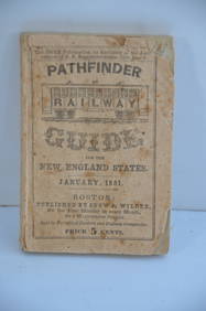
Pathfinder Railway Guide for the New England States-January 1851JM Hobby Supply and Railroad Artifact Auctions4.4(126)See Sold PriceFeb 24, 2024
LARGE EARLY 18TH C. DUTCH CHART OF UPPER NORTH AMERICA, PIERRE MORTIER (1661-1711), FRAMEDThomaston Place Auction Galleries4.4(386)See Sold PriceFeb 24, 2024
Numismatic Books - Boyne - Tokens Issued in the Seventeenth Century in England, Wales, and IrelandTimeLine Auctions Ltd.4.5(183)See Sold PriceMar 09, 2024
Chanel Burgundy Leather Double Flap BagDOYLE Auctioneers & Appraisers4.6(166)See Sold PriceFeb 29, 2024
Chanel Beige Quilted Calfskin Small Double Flap BagDOYLE Auctioneers & Appraisers4.6(166)See Sold PriceFeb 29, 2024
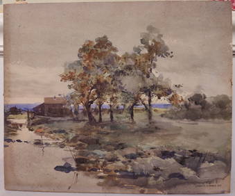
J Francis Murphy W/C New England Landscape PaintingHeritage Gallery Auctions4.4(56)See Sold PriceMar 10, 2024
[CHARLES II, KING OF ENGLAND (1630-1685)]. His Majestie’s D...Potter & Potter Auctions4.6(539)See Sold PriceMar 07, 2024
New In Box Nascar & John Deere Pocket KnivesJudd's Auction Gallery, Inc. 4.6(164)See Sold PriceFeb 25, 2024
West Indies Islands. Guadaloupe. | Mariegalante &C. | Antigua.Jasper524.5(9.8k)See Sold PriceFeb 27, 2024
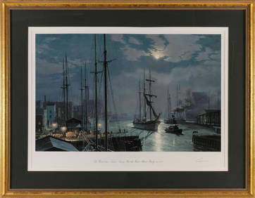
JOHN STOBART (Massachusetts/Florida/England, 1929-2023), "Chicago The Barkentine 'Naiad' Towing PastEldred's4.7(409)See Sold PriceMar 07, 2024


![[CHARLES II, KING OF ENGLAND (1630-1685)]. His Majestie’s D... (1 of 3)](https://p1.liveauctioneers.com/928/318880/171360926_1_x.jpg?height=282&quality=70&version=1707501302)