Sold1808 Map of England and WalesTitle: 1808 Map of England and Wales Author: Guthrie Medium: Ink on Paper Dimensions: 10.5"X8" Description: Map of England and Wales dated 1808. Part of the General Gazetteer. Engraved by P. Wogan. PuSee Sold Price
SoldMorden, Robert 1701 Hand Col Map of Staffordshire, UKHand Colored Copper Engraved Map Published 1701-08, London for "The New Description and State of England, containing the Mapps of the Counties of England and Wales" by Robert Morden. Light folds as isSee Sold Price
Sold1867 Map of England and WalesAuthor: Johnson Title: 1867 Map of England and Wales Medium: Ink on Paper Dimensions: 18"X27" Description: Double folio map of England and Wales dated 1867. Engraved by A.J.Johnson in New York. JohnsoSee Sold Price
SoldKinckelbach 1592 Map of England & WalesDESCRIPTION: Map by Quad von Kinckelbach depicts England and Wales based off an earlier map by Ortelius. Conservation framed. MEASUREMENTS: Map 7" high x 10" wide; overall with frame 13-3/4" high x 17See Sold Price
SoldMoll, Herman 1724 Hand Coloured Map of Somerset"Somersetshire" Hand Coloured Copper Engraved Map Published 1724, London for "A New Description of England and Wales" by Hermann Moll. Paper Size: 12.5 x 8 inch (32 x 20cm) A few discrete wormholes, oSee Sold Price
SoldAncient Britain ITitle: Ancient Britain I Cartographer: WALKER, J. & C. Publisher: Baldwin & Cradock/S.D.U.K. Brief Description: Roman England and Wales. Height X Width: 14.5x 11.3 Reserve: $25.00 Shipping: DomesSee Sold Price
Bacon, G. W. 1898 Lot of 35 British County MapsIncl Devon North and South, Hampshire, Lancashire North and South, Leicester/Rutland, Lincoln, Monmouth, Salop (Shropshire) Staffordshire, Yorkshire, England/Wales, England SW, England SE, Wales N, WaSee Sold Price
SoldBacon, G. W. 1898 Lot of 35 British County MapsIncl Devon North and South, Hampshire, Lancashire North and South, Leicester/Rutland, Lincoln, Monmouth, Salop (Shropshire) Staffordshire, Yorkshire, England/Wales, England SW, England SE, Wales N, WaSee Sold Price
Sold1885 Cathedral Churches England & Wales Illustrated1885 Cathedral Churches England & Wales Illustrated Gothic Architecture BEAUTY Main author: Bonney, T. G (edit.) Title: The Cathedral churches of England and Wales : descriptive, historical, pictorialSee Sold Price
Sold1814 ATLAS Maps of England & Wales Scotland Color Nav1814 ATLAS Maps of England & Wales Scotland Color Navigation Travel John Cary An incredible atlas consisting of 42 color maps of Great Britain by John Cary. The atlas covers cities in England, Wales,See Sold Price
Sold1798 1ed Cary ROADS New Itinerary England Wales1798 1ed Cary ROADS New Itinerary England Wales Topography Atlas Travel Guide John Cary was a famous English cartographer from the 18th-century. Cary gained his reputation as a map maker from his workSee Sold Price
Bowen: Antique Map of England & Wales, 1747Map: 1747 Bowen Map of England and Wales -- A New and Very Accurate Map of South Britain or England and Wales... Cartographer: E Bowen Year / Place: 1847 c., London Map Dimensions: 15.5 X 16.5 in. ConSee Sold Price
SoldRARE ANTIQUE 1796 NEEDLEPOINT SAMPLER MAP OF ENGLAND WALESRARE ANTIQUE 1796 NEEDLEPOINT SAMPLER MAP OF ENGLAND WALES ——MEASURES APPROXIMATELY —21"X22"——All items Located in Hollywood Florida Warehouse. Thank you for your inquirySee Sold Price
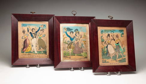
SoldENGLAND & WALES. London Newcastle Doncaster racesTITLE/CONTENT OF MAP: 'England and Wales' Vignettes: London; Entrance to Portsmouth Harbour; Newcastle-upon-Tyne; Fox hunting; Sunderland Bridge; Oxford; The grand stand on the race ground, DoncasterSee Sold Price
Sold'Walker's tour through England & Wales, a new'Walker's tour through England & Wales, a new geographical pastime', published by William Darton, comprising fold-out map in cardboard sleeve, and counters in original box,See Sold Price
SoldBritish Isles: C England Wales Scotland Ireland MapBritish Isles: Counties. England Wales Scotland Ireland. Tallis/rapkin 1851 Map. Vignettes: London; Edinburgh; Dublin. Approx 36.5 x 26.5cm, 14.5 x 10.25 inches (Large). Antique engraved map by J RapkSee Sold Price
SoldCary, John 1812 Large Hand Col Map of England & Wales"A New Map of England and Wales. Adapted to Cary's New Itinerary" Hand Coloured Copper Engraved Map Published 1812, London for "Cary's Traveller's Companion" by John Cary. Paper Size: 19 x 15 inch (48See Sold Price
Cary: Large Map of England, Wales, Scotland, 1796Map: Cary’s reduction of his Large Map of England and Wales, with part of Scotland; Publication Date: 1796-02-20 Maker: John Cary, John Cary Publisher: John Cary Size: Elephant Folio – 29.3 H x 24See Sold Price
Sold1813, ENGLISH NEEDLEWORK MAP OF WALES & ENGLANDBritish, 1813. English needlework map depicting England and Wales from the English Channel to the Scottish border.. Signed "M. MulIinder" and "FINISHED / April 15th, 1813". Approx. 26.5" x 24" (frame)See Sold Price
Sold1814 Thomson Map of England and Wales -- EnglandTitle/Content of Map: 1814 Thomson Map of England and Wales -- England Date: 1814, London Cartographer: J Thomson Size: 20.5 X 25.2 in. This in attractive larger map of England and Wales.It provides aSee Sold Price
SoldSpeed (John) England, Wales, Scotland and IrelandSpeed (John) England, Wales, Scotland and Ireland Described,engraved pictorial title and 63 maps, including 2 folding of the British Isles and Yorkshire, by Pieter van den Keere., some ff. triSee Sold Price
SoldC.1645 MAP OF ENGLAND& WALES HAND COLORED BY BLAEU 18 1/2" X 22 3/4" OVERALLC.1645 MAP OF ENGLAND& WALES HAND COLORED BY BLAEU 18 1/2" X 22 3/4" OVERALLSee Sold Price
SoldA Map of England & Wales"A Map of England & Wales". Needlework on silk. 14 1/2" x 13 1/2".See Sold Price
SoldWalker (J. & C.) A Geological Map of England, WaleWalker (J. & C.) A Geological Map of England, Wales, and Part of Scotland,with Geological and Mineralogical Section from Land's End to the German Ocean, and St. George's Channel to the GermanSee Sold Price
1798 Hand-Written Colonial American Hymnal Leather-Bound Book Signed Abraham Ford New England TownsHess Fine Auctions4.5(197)See Sold PriceMar 02, 2024
Numismatic Books - Boyne - Tokens Issued in the Seventeenth Century in England, Wales, and IrelandTimeLine Auctions Ltd.4.5(183)See Sold PriceMar 09, 2024
1861 ARCHITECTURE 1ed Handbook to Cathedrals England 100+ Full Page EngravingsSchilb Antiquarian Rare Books4.8(421)See Sold PriceMar 31, 2024
1896 Cardiff Wales United Kingdom England Cover To Breslau Germany Stamp DealerMynt Auctions4.6(680)See Sold PriceFeb 26, 2024
1939 Argentina Airmail Cover Buenos Aires to Mold North Wales EnglandMynt Auctions4.6(680)See Sold PriceFeb 26, 2024
[CHARLES II, KING OF ENGLAND (1630-1685)]. His Majestie’s D...Potter & Potter Auctions4.6(539)See Sold PriceMar 07, 2024
THREE HAND COLORED AND ADORNED PRINTS.Amelia Jeffers, Auctioneers & Appraisers4.6(101)See Sold PriceMar 08, 2024
Books: A quantity of assorted books on the subject of Women, to include The Life of Catherine BoothClaydon Auctioneers Ltd4.3(125)See Sold PriceFeb 26, 2024
Book: The Romantic and Picturesque Scenery of England and Wales, by P. J. Loutherbourg. ReproducedClaydon Auctioneers Ltd4.3(125)See Sold PriceFeb 26, 2024
Birmingham, England. Antique silver salt cellar. Neoclassical style. Dated 1902/03.Jasper524.5(9.8k)See Sold PriceFeb 27, 2024
Late 18th century map of England and Wales sampler and two printsFellows4.3(159)See Sold PriceMar 05, 2024
Brass Rubbing Art, Simon De WensleyRapid Estate Liquidators and Auction Gallery4.5(1.1k)See Sold PriceFeb 28, 2024
2.3 ctw Certified VS/SI Diamond Halo Ring 18k Yellow GoldPacific Global Auction3.9(272)See Sold PriceJul 27, 2024


![[CHARLES II, KING OF ENGLAND (1630-1685)]. His Majestie’s D... (1 of 3)](https://p1.liveauctioneers.com/928/318880/171360926_1_x.jpg?height=282&quality=70&version=1707501302)