SoldEMANUEL BOWEN (English, active 1720-1760). A New aEMANUEL BOWEN (English, active 1720-1760). A New and Accurate Map of Virginia and Maryland. Etching with hand-coloring, circa 1747 - 13 x 9 1/4 in. PROVENANCE: Darnall's Chance House Museum, Upper MSee Sold Price
Soldc.1760, A New General Map of America by BowenHistoric Maps"A New General Map of America" by Emanuel Bowen c.1760, "A New General Map of America", by Emanuel Bowen, Choice Extremely Fine. This Hand-colored map features North and SSee Sold Price
Soldc.1760, A New General Map of America by BowenHistoric Maps"A New General Map of America" by Emanuel Bowen c.1760, "A New General Map of America", by Emanuel Bowen, Choice Extremely Fine. This Hand-colored map features North and SSee Sold Price
3 MAPS, FALKLAND ISLANDS & SOUTH AMERICAGroup of three maps of South America with the Falkland Islands comprising Emanuel Bowen (English 1694-1767), "New and Accurate Map of Chili, Terra Magellanica, Terra del Fuego &c.", circa 1774; blackSee Sold Price
Sold18th Century Map of Carolinas and Georgia, BowenEmanuel Bowen (English, 1694-1767), "A New & Accurate Map of the Provinces of North & South Carolina, Georgia"-1747. An early English map of the Southern United States by engraver Emanuel Bowen (EngliSee Sold Price
SoldEmanuel Bowen, "New & Accurate Map of Brasil"Emanuel Bowen (English, 1693-1767). "A New & Accurate Map of Brasil, Divided into its Captainships". An engraved map, with vibrant hand coloring, depicting Brasil and a segment with the Isle of St. KaSee Sold Price
Soldc. 1760, MAP, A New General Map of America.Historic Maps"A New General Map of America..." After Emanuel Bowen c. 1760, Printed Map Entitled, "A New General Map of America. Drawn from several Accurate particular Maps and Charts and ReguSee Sold Price
SoldMAP, NEW ACCURATE MAP OF JAMAICA, C. 1747, BOWENUnframed map: "A New and Accurate Map of the Island of Jamaica..." c. 1747, by Emanuel Bowen (English, 1694-1767), inset maps of the "Harbour of Port Antonio & St. Francis" and "Port Royal or KingstonSee Sold Price
MAP: NEW ACCURATE MAP OF JAMAICA, BOWEN, c.1747Unframed map: "A New and Accurate Map of the Island of Jamaica..." c. 1747, by Emanuel Bowen (English, 1694-1767), inset maps of the "Harbour of Port Antonio & St. Francis" and "Port Royal or KingstonSee Sold Price
Sold18th Century Map of the SoutheastLondon, 1747, [A New & Accurate Map of the Provinces of North & South Carolina, Georgia, & C.,] by Emanuel Bowen (1720-1767), noting towns, forts and Indian populations, "Country of the Charokees [sicSee Sold Price
SoldEmanuel Bowen North and South Carolina Map, 1747[A New & Accurate Map of the Provinces of North & South Carolina, Georgia, & C.,] by Emanuel Bowen (1720-1767), London, 1747, engraving with hand colored highlights, on laid paper, with title cartouchSee Sold Price
Sold18th century Bowen map of Carolinas,[A New & Accurate Map of the Provinces of North & South Carolina, Georgia, & C.,] Emanuel Bowen (1720-1767), "Country of the Cherokees" shown extending to Louisiana, 16 x 18-1/2 in.; modern wood frameSee Sold Price
Emanuel Bowen (1694-1767, English)"New and accurate map of Persa", coloured engraving_x000D_ 15.5 x 20 inches, minor loss - bottom left (border)See Sold Price
SoldRare James Banks Pair-Cased Verge Watch, 18th C.Bartholomew Barwell (English/American, active in New York 1749-1760, from Bath, England) and James Banks (English, 18th century), early 18th century. Exceedingly rare and finely rendered pair-cased veSee Sold Price
Rare James Banks Pair-Cased Verge Watch, 18th C.Bartholomew Barwell (English/American, active in New York 1749-1760, from Bath, England) and James Banks (English, 18th century), early 18th century. Exceedingly rare and finely rendered pair-cased veSee Sold Price
SoldEMANUEL BOWEN (BRITISH, 1720-1767) MAP OF THE SOUTHEASTEMANUEL BOWEN (BRITISH, 1720-1767) MAP OF THE SOUTHEAST hand-colored engraving on laid paper, A New and Accurate Map of the Provinces of North & South Carolina, Georgia, &c. Drawn from late Surveys anSee Sold Price
SoldBowen PLAN OF THE CITY AND HARBOR OF LA VERA CRUZ ANDDetails: BOWEN, Emanuel (c.1720-67, engraver). A plan of the City and Harbour of La Vera Cruz and the Castle of San Juan de Ulua being the key of traffick and the principal port of New Spain. [LondonSee Sold Price
SoldEmanuel Bowen, A New & Accurate Map of Louisiana......with Part of Florida and Canada and the Adjacent Countries Drawn from Surveys assisted by the most approved English & French Maps & Charts., copperplate engraving with outline color, from A CompletSee Sold Price
SoldAn Emanuel Bowen Handtinted MapAn Emanuel Bowen Handtinted Map "A New and Accurate Map of Nubia & Abyssinia........", attributed in the image to Bowen, an 18th C English cartographer. Unframed and matted for framing, 14" h, 17" w.See Sold Price
SoldPartial atlas with maps by Emanuel BowenHeading: Author: Bowen, Emanuel Title: [The Large English Atlas] Place Published: [London] Publisher: Date Published: [1760] Description: 9-990 pp. Illustrated with 22 maps, incSee Sold Price
SoldENGLISH MAP OF THE UNITED PROVINCES EMANUEL BOWENENGLISH MAP OF THE UNITED PROVINCES, EMANUEL BOWEN, H 14" W 17":Inscribed at the upper right, "A New and Correct Map of the Seven United Provinces, Drawn from the most Approved Maps and Charts: the WhSee Sold Price
ENGLISH MAP OF THE UNITED PROVINCES EMANUEL BOWENENGLISH MAP OF THE UNITED PROVINCES, EMANUEL BOWEN, H 14" W 17":Inscribed at the upper right, "A New and Correct Map of the Seven United Provinces, Drawn from the most Approved Maps and Charts: the WhSee Sold Price
SoldEARLY MAP OF THE WORLD BY EMANUEL BOWEN. English,EARLY MAP OF THE WORLD BY EMANUEL BOWEN. English, published "1744". An engraving on laid paper with handcoloring. Good condition with fold lines and minor edge roughness. 15 3/4" x 18 3/8". ContemporaSee Sold Price
SoldAntique Map Of Northern GermanyMeasuring 25" X 22" by Emanuel Bowen, (1720-1767) Shipping: We are unable to ship this item. Please contact our local UPS Store, store1152@theupsstore.com, or the Packaging Store, hello@packandshipnowSee Sold Price
Frank Brangwyn (1867 - 1956) Set of 4 Mural Studies in Original FramesDonny Malone Auctions4.4(1.8k)See Sold PriceMar 04, 2024
Robert Goss Bowen Jr (NJ,mid 20C) oil paintingBroward Auction Gallery4.7(292)See Sold PriceApr 14, 2024
[ARCTIC]. BOWEN, Emanuel. A New & Accurate Map of the North...Potter & Potter Auctions4.6(545)See Sold PriceMar 07, 2024
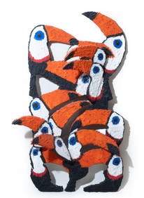
Signed Hunt Slonem, Oil on Panel Wall Sculpture, 1999 "Toco"Collective Hudson4.5(58)See Sold PriceMar 01, 2024
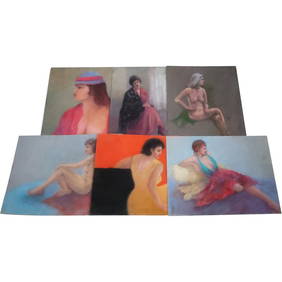
6 Assorted Pastel Paintings Nudes by Listed American Artist Madlyn-Ann Crawford WoolwichDonny Malone Auctions4.4(1.8k)See Sold PriceMar 04, 2024
Lot of 5 Edward Staloff (1893 - 1989) Very Large Film Negatives.Westside Traders Emporium4.5(34)See Sold PriceFeb 27, 2024
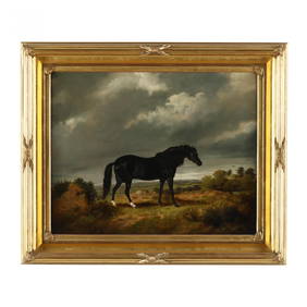
George Morley (English, active c.1831-1889), Horse in a LandscapeLeland Little4.5(701)See Sold PriceFeb 29, 2024
Antonie Waterloo 1834 engraving Landscape with Figures signedKCM Galleries4.7(164)See Sold PriceFeb 25, 2024
Thomas Sword Good The Newspaper (A Man Reading) 1852 engravingKCM Galleries4.7(164)See Sold PriceFeb 25, 2024
BROADBILL DRAKE, J. ENGLISHFrank and Frank Sporting Collectibles LLC4.7(167)See Sold PriceMar 10, 2024
(11) various early & middle 20th c booksWilliam Bunch Auctions & Appraisals4.6(878)See Sold PriceFeb 27, 2024
18TH C. CHIPPENDALE RED PAINTED BLANKET CHEST.William Smith Auctions4.6(147)See Sold PriceMar 06, 2024
Frank McCarthy Native American Ltd Ed PrintCordier Auctions & Appraisals4.4(1.5k)See Sold PriceMar 02, 2024
Queen Anne Style 3-Light Silver Plate CandelabraAuctions at Showplace4.6(740)See Sold PriceApr 16, 2024


![[ARCTIC]. BOWEN, Emanuel. A New & Accurate Map of the North... (1 of 1)](https://p1.liveauctioneers.com/928/318880/171360917_1_x.jpg?height=282&quality=70&version=1707501302)