Soldc.1760, A New General Map of America by BowenHistoric Maps"A New General Map of America" by Emanuel Bowen c.1760, "A New General Map of America", by Emanuel Bowen, Choice Extremely Fine. This Hand-colored map features North and SSee Sold Price
Soldc.1760, A New General Map of America by BowenHistoric Maps"A New General Map of America" by Emanuel Bowen c.1760, "A New General Map of America", by Emanuel Bowen, Choice Extremely Fine. This Hand-colored map features North and SSee Sold Price
Soldc. 1760, MAP, A New General Map of America.Historic Maps"A New General Map of America..." After Emanuel Bowen c. 1760, Printed Map Entitled, "A New General Map of America. Drawn from several Accurate particular Maps and Charts and ReguSee Sold Price
SoldMap, Eman. Bowen, A New General Map of AmericaFramed hand-colored engraved map, ''A New General Map of America,'' circa 1747, by Eman. Bowen, overall: 16.25''h x 20.5''wSee Sold Price
Sold'A New General Map of America' Dated 1747Antique map of America in copper plate engraving by Emanuel Bowen dated 1747, London. COA from Marlborough Antiques on verso. Has been hand colored, framed in burl wood. Measures 20.25"H x 23.25"W fraSee Sold Price
SoldBowen's [A New General Map of America], 1747hand-colored decorative map of North and South America, with decorative title cartouche, 14-1/2 x 17-1/2 in. (sight); matted and framed, 21-1/4 x 23-3/4 in.; together with a framed biography of EmanueSee Sold Price
Bowen's [A New General Map of America], 1747hand-colored decorative map of North and South America, with decorative title cartouche, 14-1/2 x 17-1/2 in. (sight); matted and framed, 21-1/4 x 23-3/4 in.; together with a framed biography of EmanueSee Sold Price
SoldJigsaw Puzzle Map of Americas 1813Heading: (Games & Puzzles) Author: Laurie & Whittle Title: Laurie & Whittle's New General Map of America Compiled from the most Authentic Materials London Published Sepr. 16th, 1813, by Laurie & WhittSee Sold Price
SoldMap of America, Laurie and Whittle 1813Antique Map of America, "Laurie & Whittle's New General Map of America, Compiled from the Most Authentic Materials", London, Laurie and Whittle, 1813, hand-colored engraved map, 19 in. x 23 in., frameSee Sold Price
LAURIE, ROBERT; and WHITTLE, JAMES. New General Map ofLAURIE, ROBERT; and WHITTLE, JAMES. New General Map of America. Double-page engraved map of North and South America. 20x24¼ inches sheet size, ample margins; original hand-color in full; center sSee Sold Price
SoldLAURIE, ROBERT; and WHITTLE, JAMES. New General Map ofLAURIE, ROBERT; and WHITTLE, JAMES. New General Map of America. Double-page engraved map of North and South America. 20x24¼ inches sheet size, ample margins; original hand-color in full; center sSee Sold Price
SoldMAP-1750 New and Accurate Map of America By BowenHistoric Maps1750 "A New and Accurate Map of America..." By Bowen 1750 Engraved Hand-Colored Map entitled, "A New and Accurate Map of America..." engraved by Emanuel Bowen, Choice VerySee Sold Price
SoldTWO MAPS OF AMERICA. - 11 x 17 1/4 in., the largeTWO MAPS OF AMERICA. A New and Accurate Map of North America" by Thomas Bowen, circa 1800; "Carte de la Parite Sud des Etats Unis" by M. Bonne, circa 1790. Engravings with hand-coloring - 11 x 17 1/4See Sold Price
SoldAmerica.- Bowen (Emanuel) A New & Accurate Map ofAmerica.- Bowen (Emanuel) A New & Accurate Map of Louisiana, with Part of Florida and Canada, and the Adjacent Countries; A New & Accurate Map of the Islands of Newfoundland, Cape Breton, St. John andSee Sold Price
SoldJ. Thomson map- ''America''A Map of ''America,'' John Thomson,- engraving depicting both North and South America, from Thomson's ''New General Atlas'', 1814. 18 x 20 1/4''See Sold Price
SoldAmerica.- Bowen (Emanuel) A New & Accurate Map of theAmerica.- Bowen (Emanuel) A New & Accurate Map of the Provinces of North & South Carolina Georgia &c., detailed map showing the region from Chesapeake Bay to St. Augustine, Florida and west to PensacoSee Sold Price
SoldMap, "America Drawn & EngravedFor Thomson's New General Atlas, July 1, 1813. J & G Menzies. Sculpt." 3 1/2" L. tear in right margin, not affecting plate mark or image. Toning and light soil. Very Good overall. 21 1/2" x 29". FromSee Sold Price
Sold2 pieces. Hand-Colored Maps - North America: Bowe2 pieces. Hand-Colored Maps - North America: Bowen, Thomas. A New and Accurate Map of North America." [London], [1779]. Engraving. 10 1/2 x 17 1/2 inches; 260 x 430 mm. Orig. color, slightly age tonedSee Sold Price
SoldEvans Middle Dominions of US mapEvans, Lewis (c. 1700 – 1756). A New & General Map of the Middle Dominions Belonging to the United States of America... Engraving with original hand color in full. London: Laurie & Whittle, 179See Sold Price
SoldSouth America.- Bowen (Emanuel) Four maps, including:South America.- Bowen (Emanuel) Four maps, including: 'A New and Accurate Map of Brasil'; '... Chili, Terra Magellanica, Terra del Fuego &c.'; '... Peru and the Country of the Amazones'; and '... ParaSee Sold Price
Sold(Maps and Charts, North America), Bowen, Thomas, A(Maps and Charts, North America), Bowen, Thomas, A New & Accurate Map of North America Drawn from the Most Authentic Modern Maps and Charts, 1777, taken from Middleton's Complete System of Geography,See Sold Price
SoldMap, "North America" by Aaron Arrowsmith,Map, "North America" by Aaron Arrowsmith, engraved by Thomas & Hall, published 1823 by A. Constable & Co. Edinburgh, this map was included in Arrowsmith's "New General Atlas", although the majority ofSee Sold Price
SoldLewis Evans, A New and General Map of the MiddleEVANS, Lewis (ca 1700-1756). A New and General Map of the Middle Dominions belonging to the United States of America. London: Laurie & Whittle, 1793. Single sheet, matted and framed (ca 20 x 26 4/8 inSee Sold Price
Sold[A New and General Map of the MiddleDominions Belonging to the United States of America, etc.] London: Laurie and Whittle, 1794, Tooley p. 68, a partially hand-colored in outline map of the eastern part of the United States, with a niceSee Sold Price
1867 Map of the Railroads of The State of New YorkRail & Road Auctions4.6(165)See Sold PriceMar 08, 2024
[ARCTIC]. BOWEN, Emanuel. A New & Accurate Map of the North...Potter & Potter Auctions4.6(538)See Sold PriceMar 07, 2024
Arrowsmith & Lewis - Map of PolynesiaTrillium Antique Prints & Rare Books4.5(28)See Sold PriceFeb 24, 2024
Arrowsmith & Lewis - Map of North AmericaTrillium Antique Prints & Rare Books4.5(28)See Sold PriceFeb 24, 2024
Arrowsmith & Lewis - Map of the World on Mercator's ProjectionTrillium Antique Prints & Rare Books4.5(28)See Sold PriceFeb 24, 2024
Arrowsmith & Lewis - Map of LouisianaTrillium Antique Prints & Rare Books4.5(28)See Sold PriceFeb 24, 2024
Arrowsmith & Lewis - Map of the United StatesTrillium Antique Prints & Rare Books4.5(28)See Sold PriceFeb 24, 2024
Map: An 18thC engraved and hand coloured map of North America and South America, titled DeClaydon Auctioneers Ltd4.3(125)See Sold PriceFeb 26, 2024
West Indies Islands. Guadaloupe. | Mariegalante &C. | Antigua.Jasper524.5(9.7k)See Sold PriceFeb 27, 2024
1750 Bowen Map of Bermuda and St. Kitts -- A New & Accurate Map of Bermudas or Sommer's Islands...Jasper524.5(9.7k)See Sold PriceFeb 27, 2024
Map of Mexico, Central America, New Grenada, Venzuela and the West IndiesJasper524.5(9.7k)See Sold PriceFeb 27, 2024
New and Correct Map of North America With the West India Islands,Jasper524.5(9.7k)See Sold PriceFeb 27, 2024
Buffon, Vaugody & Bell 1785 America - Map of the New ContinentAlbion Auctions4.7(335)See Sold PriceMar 01, 2024
Herman Moll A New Map of Ye North Parts of AmericaWillow Auction House4.5(280)See Sold PriceMar 14, 2024
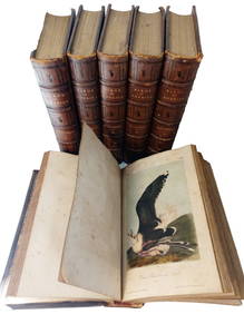
JJ Audubon 1861 6 Vols Birds of America Bowen Illus Full Leather V1-5 V7 1-350p Book SetHess Fine Auctions4.4(195)See Sold PriceMar 02, 2024


![Bowen's [A New General Map of America], 1747 (1 of 5)](https://p1.liveauctioneers.com/33/111301/57151007_1_x.jpg?height=282&quality=70&version=1508861891)
![Bowen's [A New General Map of America], 1747 (1 of 5)](https://p1.liveauctioneers.com/33/106293/54445338_1_x.jpg?height=282&quality=70&version=1499525086)


![[ARCTIC]. BOWEN, Emanuel. A New & Accurate Map of the North... (1 of 1)](https://p1.liveauctioneers.com/928/318880/171360917_1_x.jpg?height=282&quality=70&version=1707501302)