SoldELEVEN MAPS. - unframed.ELEVEN MAPS. United States of America. John Melish, published by Carey & Son, 1820 (17 1/2 x 22) Map of Long Island. De Beers, NY, c. 1840, a fold out map in brown buckram covers (13 x 50 in.). TerraSee Sold Price
SoldAfter Major James Rennell (1742-1830) British. "TheAfter Major James Rennell (1742-1830) British. "The Peninsula of India", Map, Unframed, 19" x 17", and Ten other various Maps of the World by other hands, Eleven (11).See Sold Price
SoldLevasseur's Atlas National Illustre (11) MapsEleven (11) Maps from Levasseur's Atla National Illustre. French 1856. Sheets measure 13.875 x 20.75 in. . Unframed, loose and not glued or mounted. If lot is absent of a condition report one may be rSee Sold Price
SoldEleven Assorted Unframed Engravings, including fouEleven Assorted Unframed Engravings, including four maps of islands, three with hand-coloring, three small scenic, three small figural, and one botanical.See Sold Price
SoldEuropean School: Miscellaneous Group of Eleven PrintsEuropean School: Miscellaneous Group of Eleven Prints Eleven lithographs, etchings and engravings, one map with hand-coloring, on various papers. Various sizes, all unframed.See Sold Price
SoldEleven unframed samplers, 18th/19th c., togetherEleven unframed samplers, 18th/19th c., together with three silk and metallic thread floral panels.See Sold Price
SoldLot Old Maps -- Unframed Posters -- Misc. HousewaresLot Old Maps -- Unframed Posters -- Misc. Housewares.See Sold Price
SoldChinese School (19th Century) Set of Eleven unframedChinese School (19th Century) Set of Eleven unframed pith paper works, various subjects. Each 12ins x 8ins. (11)See Sold Price
SoldHarold Hope Read, eleven unframed watercolours, pastelsHarold Hope Read, eleven unframed watercolours, pastels and other drawings, interior, figure and other studiesSee Sold Price
Sold19TH C. ATLAS MAP, UNFRAMED"Brazil", by John Rapkin (1815-1876), illustrations by R. Winkler. circa 1851, unframed, matted, 14" x 10" image. Good condition.See Sold Price
SoldTHREE MAPS. - unframed.THREE MAPS. A New Map of the Russian Empire. London, J. Cary, 1799, two sheets. Partie Meridionale des Etats de Castille. Paris, Robert de Vaugondy, 1757. The Road from London to Weymouth, London, JohSee Sold Price
SoldThree Virginia Maps, Unframed165. Three Virginia Maps, Unframed: 1855 Handcolored Wood Engraved Map, 1 1/2 x 9". 1866 Miniature Hand Colored Map with West Virginia, 3 x 5 1/4. 11" X 14" Rand McNally Colored County Map of VirginiaSee Sold Price
SoldEleven Unframed Costume Designs by Robert Fletcher,Eleven Unframed Costume Designs by Robert Fletcher, including three pen and ink with watercolor designs on Arches paper for a 1960 production of The Tempest, an attributed watercolor on Arches paper dSee Sold Price
Posters, Map, UnframedPosters and map, including: 1.) Two copies "Schmuck Kunst Der Moderne." [32 x 23 inches. 2.) Map: "Huahine to Maupin - South Pacific Ocean." [28 x 40 inches].See Sold Price
SoldA QUANTITY OF LONDON MAPS, unframed. 43 cm x 57 cm.A QUANTITY OF LONDON MAPS, unframed. 43 cm x 57 cm. (qty)See Sold Price
SoldA HAND PAINTED OTTOMAN MAP, unframed, 39cm x 56cm.A HAND PAINTED OTTOMAN MAP, unframed, 39cm x 56cm.See Sold Price
SoldGroup of Maps of RussiaGroup of eleven maps of Russia. Includes: "Accurate Map of the Russian Empire as contained in Europe and Asia" by Thomas Bowen, 1778; "Plan of the Bay of Awatska on the East Coast of Kamtschatka" inclSee Sold Price
SoldWorld War II Captured German Service MapsWorld War II Captured German Service Maps Eleven maps including Borczyskowo, Neuteich, Waldfeucht, Waitze, Neustadt, Seesen, Sierakowo, Samter, Strelno, Lagenleuba and Landschafspolder; some from theSee Sold Price
SoldGrp: 11 Maps of ItalyGroup of eleven maps of Italy. Philipp Cluver map of Italy "Italiae Antiquae Delineatio" W. Poyntell & Co.; Barlow map of "Italy from the Best Authorities" C.Brightly & T.Kinnersley, Suffolk, 1806; JeSee Sold Price
SoldAntique Map Lithographs New York City, World MapPair Antique Hand Colored Map Lithographs of New York City, and a World Map. Unframed 18 inches x 23 inchesSee Sold Price
SoldAMERICAN CIVIL WAR ATLAS MAP PAGE PRINT COLLECTIONEleven maps from an atlas produced on the American Civil War, depicting various battlefields and fortifications from the war. Includes battlefields of South Mountain, Winchester, Virginia, the fortifiSee Sold Price
SoldJohann Baptista Homann (1664-1724) German. "RegnorumJohann Baptista Homann (1664-1724) German. "Regnorum Sicilliae et Sardiniae", Map, Unframed, 19" x 22.25".See Sold Price
Orlando Botero (CA,b 1946) mixed media paintingBroward Auction Gallery4.7(292)See Sold PriceMar 31, 2024
SALVADOR DALI Le Voyage Fantastique 11 X Color Litho 50/195 1981 Framed GenuineLuis Porretta Fine Arts4.3(10)See Sold PriceMar 02, 2024
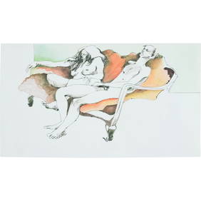
Henry Moore 1976, Mixed Media Ink and Watercolor Reclining Nudes on Sofa Man and Woman, SignedDonny Malone Auctions4.4(1.8k)See Sold PriceMar 04, 2024
Map of the Count of Flanders, 1700 by Gillaume de Lisle, ParisAntiques Online Auctions4.6(415)See Sold PriceMar 14, 2024
Map of Turkey from Arabic and Persia, 1701 by Gillaume de Lisle, ParisAntiques Online Auctions4.6(415)See Sold PriceMar 14, 2024
Map of United States of North America, 1785Antiques Online Auctions4.6(415)See Sold PriceMar 14, 2024
Antique Map of Poland, 1700 by Guillaume De Lisle, ParisAntiques Online Auctions4.6(415)See Sold PriceMar 14, 2024
The Kingdom of Dalmatia Territories Map, 1700Antiques Online Auctions4.6(415)See Sold PriceMar 14, 2024
Antique Map of France, 1703 by Gillaume Del Isle PrintAntiques Online Auctions4.6(415)See Sold PriceMar 14, 2024
Nancy Graves (American, 1939-1995) Lithograph in Colors on Arches Paper 1972, "Lunar Landscape V", HDuMouchelles4.6(830)See Sold PriceMar 15, 2024