SoldLevasseur's Atlas National Illustre (11) MapsEleven (11) Maps from Levasseur's Atla National Illustre. French 1856. Sheets measure 13.875 x 20.75 in. . Unframed, loose and not glued or mounted. If lot is absent of a condition report one may be rSee Sold Price
SoldLevasseur (11) Maps Atlas National Illustre' 1856Levasseur Maps; group of 11 hand-colored engravings from the Atlas National Illustre' (French) 1856. Measure 13 7/8" x 20.75" sheet size. These plates have not been folded. Some browning and spottingSee Sold Price
SoldV. LEVASSEUR FRENCH MAP ATLAS NATIONAL ILLUSTREV. LEVASSEUR, FRENCH MAP, ATLAS NATIONAL ILLUSTRE, 11" X 17", 'DEPT. DE VAR./REGION DU SUD':Under glass, matted, in a bird's eye maple frame. Laguillermie et Rainaud printmakers. Atlas National IllustSee Sold Price
SoldV. LEVASSEUR FRENCH MAP ATLAS NATIONAL ILLUSTREV. LEVASSEUR, FRENCH MAP, ATLAS NATIONAL ILLUSTRE, 1852, 11" X 17", 'DEPT. DE PUY DE DOME':Under glass, matted, in a bird's eye maple frame. The map proper is surrounded by elaborate decorative engravSee Sold Price
SoldPlanisphere Planisphere,V. Levasseur, Planisphere, lithograph, from V. Levasseur, Atlas National Illustre...de France Paris: A. Combette, ca.1854. , 16 x 11.5 16 x 11.5See Sold Price
Colonies Francaises. Isle de Martinique-Amerique duV. Levasseur, Colonies Francaises. Isle de Martinique-Amerique du Sud, lithograph, from V. Levasseur, Atlas National Illustre...de France Paris: A. Combette, ca.1854, 16.5 x 11.5 16.5 x 11.5See Sold Price
Sold33 maps from Levasseur’s “Atlas National Illustre"[France] 33 Maps from an edition of Levasseur’s “Atlas National Illustre Des 86 Departements et Possessions de la France,” [1845 – 1860s]. The maps show the political boundaries, towns, and roSee Sold Price
LevasseurTwo (2) Maps from Levasseur's Atlas National Illustre. These measure approximately 22 in. x 14.5 in. and boards measure 23 in. x 16 in. If lot is absent of a condition report one may be requested viaSee Sold Price
Sold19TH CENTURY HAND COLORED DEPT. DE LA CÔTE D'OR MAP FRANCE1857 map of French department of cote d'or France. Part of France's burgundy or bourgogne wine region. decorative engravings around map. published by Victor Levasseur. Atlas National IllustreSee Sold Price
Sold[France] Maps from Levasseur’s 'Atlas National'[France] 7 Maps from an edition of Levasseur’s “Atlas National Illustre Des 86 Departements et Possessions de la France,” [1845 – 1860s]. Seven hand colored 19th century prints from the 'AtlasSee Sold Price
Levasseur: Dept. de la Corse MapDetailed and decorative Corsica maps from Levasseur's illustrated Atlas National Illustré des 86 Départements de des Possessions de la France. As opposed to the earlier edition of the map (K1448), NSee Sold Price
SoldLevasseur atlas of French departments 1852Heading: Author: Levasseur, Victor Title: Atlas National Illustré des 86 Départements et des Possessions de la France, Divisé par Arrondissements, Cantons et Communea Place Published: Paris PublisSee Sold Price
Levasseur atlas of French departments 1849Heading: Author: Levasseur, Victor Title: Atlas National Illustré des 86 Départements et des Possessions de la France. Divisé par Arrondissements, Cantons et Communea. Place Published: Paris PubliSee Sold Price
Levasseur atlas of French departments 1849Heading: Author: Levasseur, Victor Title: Atlas National Illustré des 86 Départements et des Possessions de la France. Divisé par Arrondissements, Cantons et Communea. Place Published: Paris PubliSee Sold Price
SoldLevasseur (Victor)Levasseur (Victor) Atlas National Illustre des 86 departements et des Possessions de La France…, wood engraved highly decorative title, 100 wood engraved maps, outlined in colour, with detailedSee Sold Price
SoldLevasseur (V) Atlas National IllustréLevasseur (Victor) Atlas National Illustré des 86 Départements et des Possessions de La France, engraved pictorial title, statistical table, and 100 engraved maps with outline hand-colouring,See Sold Price
SoldLevasseur (Victor) Atlas National IllustréLevasseur (Victor) Atlas National Illustré des 86 Départements et des Possessions de La France, engraved pictorial title, statistical table, and 100 engraved maps with outline hand-colouring,See Sold Price
France.- Levasseur (Victor) 21 maps from: AtlasFrance.- Levasseur (Victor) 21 maps from: Atlas National Illustré des 86 Départments et des Possessions, engravings on wove paper, some outline hand-colouring, each sheet approx. 365 x 530 mSee Sold Price
Sold[Maps] Atlas National, 1856Levasseur, V[ictor]. ATLAS NATIONAL, ILLUSTRE DES 86 DEPARTMENTS ET DES POSSESSIONS DE LAS FRANCE…. Paris: Combette, 1856. Folio ( 14.25" x 10.5".) Complete with engraved double-page title and tableSee Sold Price
Levasseur (Victor) A group of 17 maps from Atlas NLevasseur (Victor) A group of 17 maps from Atlas National Illustré,regional French maps, engravings hand-coloured in outline, each c.315 x 440mm, hinged into mounts, minor surface dirt and teaSee Sold Price
SoldFrench Map AssortmentFrench Map Assortment (4) maps from the 'Atlas National Illustre' published by V. Levasseur, Paris in 1851 including 'Dept. Du Finistere', 'Dept. De Seine Et Marne', 'Dept. Du Jura' and 'Dept. Des DeuSee Sold Price
SoldLevasseur, Victor 1869 Lot 6 HC Decorative Maps FranceHand Coloured Steel Engraved Decorative Maps Published C1850, Paris for "Atlas National Illustre" by Victor Levasseur. Paper Size: 20.5 x 15 inch (52 x 38cm) Good ConditionSee Sold Price
SoldLevasseur, Victor 1869 Lot 6 HC Decorative Maps FranceHand Coloured Steel Engraved Decorative Maps Published C1850, Paris for "Atlas National Illustre" by Victor Levasseur. Paper Size: 20.5 x 15 inch (52 x 38cm) Good ConditionSee Sold Price
SoldLevasseur, Victor 1859 Lot of 6 Large French MapsIncl L'Eure, D'Eure et Loir, Finistere, Creuse, Correze, and Cotes du Nord. Steel Engraved Maps Published 1859, Paris for "Atlas National Illustre" by Victor Levasseur. Outline hand colour. Paper SizeSee Sold Price
Rand McNally Cosmopolitan World Atlas by Rand McNally 1949North American Artifact Auctions4.6(182)See Sold PriceApr 20, 2024
Distressed New York & Great Northern O Scale BoxcarsRapid Estate Liquidators and Auction Gallery4.5(1.1k)See Sold PriceFeb 24, 2024
FRENCH COLONIAL CHAD & UBANGI-SHARI (C.A.R.). Oubangui-Chari Tchad 1931 mapJasper524.5(9.8k)See Sold PriceFeb 28, 2024
Northern & Southern Africa. Maghreb. Orange River Sovereignty. HALL 1854 mapJasper524.5(9.8k)See Sold PriceFeb 28, 2024
FRENCH COLONIAL CHAD & UBANGI-SHARI (C.A.R.). Oubangui-Chari Tchad 1938 mapJasper524.5(9.8k)See Sold PriceFeb 28, 2024
FRENCH COLONIAL CHAD & UBANGI-SHARI (C.A.R.). Oubangui-Chari Tchad 1929 mapJasper524.5(9.8k)See Sold PriceFeb 28, 2024
Algeria Morocco & Tunis. North Africa. Tunisia. Maghreb. BARTHOLOMEW 1898 mapJasper524.5(9.8k)See Sold PriceFeb 28, 2024
Early colonial Africa. Inset Madeira & Aden. SIDNEY HALL 1856 old antique mapJasper524.5(9.8k)See Sold PriceFeb 28, 2024
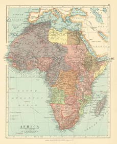
COLONIES FRANÇAISES en AFRIQUE. Africa Sénégal Madagascar. LEVASSEUR c1850 mapJasper524.5(9.8k)See Sold PriceFeb 28, 2024
Afrique. Pays des Hottentots #50. Namibia South Africa VANDERMAELEN 1827 mapJasper524.5(9.8k)See Sold PriceFeb 28, 2024
Northern & Southern Africa. Maghreb. Orange River Sovereignty. HALL 1856 mapJasper524.5(9.8k)See Sold PriceFeb 28, 2024
Africa. French West/Equatorial. Tanganyika Belgian Congo. STANFORD c1925 mapJasper524.5(9.8k)See Sold PriceFeb 28, 2024
Early colonial Africa. Inset Madeira & Aden. SIDNEY HALL 1854 old antique mapJasper524.5(9.8k)See Sold PriceFeb 28, 2024
Blackie (Pub) 1882 Folio Map. West USA - Pacific StatesAlbion Auctions4.6(336)See Sold PriceMar 01, 2024


![[France] Maps from Levasseur’s 'Atlas National' (1 of 8)](https://p1.liveauctioneers.com/5755/138410/70196116_1_x.jpg?height=282&quality=70&version=1552767267)


![[Maps] Atlas National, 1856 (1 of 8)](https://p1.liveauctioneers.com/3532/129264/65744519_1_x.jpg?height=282&quality=70&version=1539223604)