ATLAS of ANTIENT GEOGRAPHY by SAMUEL BUTLER 1843John McInnis Auctioneers,LLC4.6(502)See Sold PriceFeb 24, 2024
18TH C. ANTIQUE MAP: FRENCH & INDIAN WAR, FRAMEDThomaston Place Auction Galleries4.4(386)See Sold PriceFeb 24, 2024
Rand McNally Railroad Map Cabinet w/ 21 Railroad MapsRail & Road Auctions4.6(165)See Sold PriceMar 08, 2024
Keith Haring - Ink on New York Map, Best Buddies, Inscribed, Signed, and DatedSapphire Auction Gallery4(67)See Sold PriceMar 02, 2024
LATE 17TH C. FRENCH MAP OF THE NEW WORLD BY ALEXIS-HUBERT JAILLOT (1632-1712)Thomaston Place Auction Galleries4.4(386)See Sold PriceFeb 24, 2024
Central Railroad of New Jersey Map of Sandy Hook Route-ca. 1903JM Hobby Supply and Railroad Artifact Auctions4.4(126)See Sold PriceFeb 24, 2024
Lot of Six Mixed Atlas Box Cars-HO Scale-New in BoxJM Hobby Supply and Railroad Artifact Auctions4.4(126)See Sold PriceFeb 25, 2024
Rand McNally/Santa Fe Railroad Map of Iowa-1912JM Hobby Supply and Railroad Artifact Auctions4.4(126)See Sold PriceFeb 24, 2024
NICOLAES VISSCHER (NETHERLANDS, 1618-1709) MAP OF THE NEW WORLDThomaston Place Auction Galleries4.4(386)See Sold PriceFeb 24, 2024
17TH C. WORLD MAP BY NICOLAES VISSCHER (NETHERLANDS, 1618-1709)Thomaston Place Auction Galleries4.4(386)See Sold PriceFeb 24, 2024
Lot of Six Mixed Atlas Cabooses-HO Scale-New in BoxJM Hobby Supply and Railroad Artifact Auctions4.4(126)See Sold PriceFeb 25, 2024
Dominica, British West Indies. Caribbean. US Navy sea chart 1892 (1917) mapTITLE/CONTENT OF MAP: 'West Indies - Island of Dominica (British)' DATE PRINTED: Surveyed to 1872. Published 1892. Corrections to 1917 IMAGE SIZE: Approx 102.5 x 68.0cm, 40.5 x 26.75 inches (Large); PSee Sold Price
Dominica, British West Indies. Caribbean. US Navy sea chart 1892 (1917) mapTITLE/CONTENT OF MAP: 'West Indies - Island of Dominica (British)' DATE PRINTED: Surveyed to 1872. Published 1892. Corrections to 1917 IMAGE SIZE: Approx 102.5 x 68.0cm, 40.5 x 26.75 inches (Large); PSee Sold Price
Anguilla St. Martin/Maarten Barts. Caribbean. US Navy sea chart 1899 (1917) mapTitle: Anguilla St. Martin/Maarten Barts. Caribbean. US Navy sea chart 1899 (1917) map Description: West Indies - Leeward Islands - Anguilla, St. Martin and St. Bartholomew Islands' by From a BritishSee Sold Price
Anguilla St. Martin/Maarten Barts. Caribbean. US Navy sea chart 1899 (1917) mapTITLE/CONTENT OF MAP: 'West Indies - Leeward Islands - Anguilla, St. Martin and St. Bartholomew Islands' DATE PRINTED: Surveyed 1847. Published 1899. Corrections to 1917 IMAGE SIZE: Approx 55.0 x 66.5See Sold Price
Anguilla St. Martin/Maarten Barts. Caribbean. US Navy sea chart 1899 (1917) mapTITLE/CONTENT OF MAP: 'West Indies - Leeward Islands - Anguilla, St. Martin and St. Bartholomew Islands' DATE PRINTED: Surveyed 1847. Published 1899. Corrections to 1917 IMAGE SIZE: Approx 55.0 x 66.5See Sold Price
Two Very Scarce U.S. Navy Sea Charts of Gulf of MexicoU.S. Navy Hydrographic Office. Gulf of Mexico, West Indies and Caribbean Sea from the Most Recent U.S. Coast Survey Spanish and British Admiralty Charts Sheet I. Lithogaphed map with hand color. 1869.See Sold Price
Gulf of Mexico, West Indies and Caribbean Sea. from theTitle: Gulf of Mexico, West Indies and Caribbean Sea. from the Most Recent Spanish and British Admiralty Charts. Sheet V. Publication Date: 1870-07-01 Publisher: U.S. NAVY. HYDROGRAPHIC OFFICE Size: 2See Sold Price
Gulf of Mexico, West Indies and Caribbean Sea. from the Most Recent Spanish and British AdmiraltyPublication Date: 1870-07-01 Title: Gulf of Mexico, West Indies and Caribbean Sea. from the Most Recent Spanish and British Admiralty Charts. Sheet V. Cartographer: ANONYMOUS Publisher: U.S. NAVY. HYDSee Sold Price
Gulf of Mexico, West Indies and Caribbean Sea. from theTitle: Gulf of Mexico, West Indies and Caribbean Sea. from the Most Recent Spanish and British Admiralty Charts. Sheet V. Publication Date: 1870-07-01 Cartographer: ANONYMOUS Publisher: U.S. NAVY. HYDSee Sold Price
Gulf of Mexico, West Indies and Caribbean Sea. from theTitle: Gulf of Mexico, West Indies and Caribbean Sea. from the Most Recent Spanish and British Admiralty Charts. Sheet V. Cartographer: ANONYMOUS Publisher: U.S. NAVY. HYDROGRAPHIC OFFICE Height: 23.8See Sold Price
St Kitts Nevis Montserrat Saba Eustatius Caribbean US Navy chart 1887 (1917) mapTITLE/CONTENT OF MAP: 'West Indies - St. Eustatius, St. Christopher, Nevis and Montserrat // Aves Island (Venezuela) // St. Eustatius (Statia) // St. Christopher // Montserrat I. // Saba Island (DutchSee Sold Price
Island of Barbados. Carlisle Bay. US Navy sea chart 1887 (1920) old mapTITLE/CONTENT OF MAP: 'West Indies - Island of Barbados (British) // Carlisle Bay' DATE PRINTED: Surveyed 1869. Published 1887. Corrections to 1920 IMAGE SIZE: Approx 85.5 x 68.0cm, 33.5 x 26.75 incheSee Sold Price
Island of Barbados. Carlisle Bay. US Navy sea chart 1887 (1920) old mapTITLE/CONTENT OF MAP: 'West Indies - Island of Barbados (British) // Carlisle Bay' DATE PRINTED: Surveyed 1869. Published 1887. Corrections to 1920 IMAGE SIZE: Approx 85.5 x 68.0cm, 33.5 x 26.75 incheSee Sold Price
Island of Barbados. Carlisle Bay. US Navy sea chart 1887 (1920) old mapTitle: Island of Barbados. Carlisle Bay. US Navy sea chart 1887 (1920) old map Description: West Indies - Island of Barbados (British) // Carlisle Bay' by Original British Survey in 1869, corrected foSee Sold Price
US Navy Map of the Gulf of Mexico, 1870U.S. Navy Hydrographic Office. Gulf of Mexico, West Indies and Caribbean Sea from the Most Recent Spanish and British... Lithographed map. 1870. 23 ¾" x 35 ¾" sheet. With four inset harbor chartSee Sold Price
Gulf of Mexico, West Indies and Caribbean Sea from theReserve Reduced! Title: Gulf of Mexico, West Indies and Caribbean Sea from the Most Recent U.S. Coast Survey, Spanish and British Admiralty Charts Sheet I. Publication Date: 1869-04-14 Cartographer: ASee Sold Price
Antique British Chart of Caribbean Sea & West IndiesMap: Antique British Chart of the Caribbean Sea and West Indies Subtitle: West India Islands and Caribbean Sea. Sheet 1 comprising Florida Strait, Bahama Islands, and the Greater Antilles compiled froSee Sold Price
Gulf of Mexico, West Indies and Caribbean Sea. from theReserve Reduced! Title: Gulf of Mexico, West Indies and Caribbean Sea. from the Most Recent Spanish and British Admiralty Charts. Sheet V. Publication Date: 1870-07-01 Cartographer: ANONYMOUS PublisheSee Sold Price
SoldGulf of Mexico, West Indies and Caribbean Sea from thePublication Date: 1869-04-14 Title: Gulf of Mexico, West Indies and Caribbean Sea from the Most Recent U.S. Coast Survey, Spanish and British Admiralty Charts Sheet I. Cartographer: ANONYMOUS PublisheSee Sold Price
West Indies With The Gulf of Mexico and Caribbean SeaTitle/Content of Map: West Indies With The Gulf of Mexico and Caribbean Sea Date: 1892-06-01 Cartographer: CLOVER, RICHARDSON Publisher: HYDROGRAPHIC OFFICE, BUREAU OF NAVIGATION, NAVY DEPARTMENT SizeSee Sold Price
West Indies With The Gulf of Mexico and Caribbean SeaTitle/Content of Map: West Indies With The Gulf of Mexico and Caribbean Sea Date: 1892-06-01 Cartographer: CLOVER, RICHARDSON Publisher: HYDROGRAPHIC OFFICE, BUREAU OF NAVIGATION, NAVY DEPARTMENT SizeSee Sold Price
West Indies With The Gulf of Mexico and Caribbean SeaTitle/Content of Map: West Indies With The Gulf of Mexico and Caribbean Sea Date Printed: 06/01/1892 Cartographer: CLOVER, RICHARDSON Size (inches): 20.75X34 Highly detailed official navy chart with sSee Sold Price
West Indies With The Gulf of Mexico and Caribbean SeaTitle: West Indies With The Gulf of Mexico and Caribbean Sea Publication Date: 1892-06-01 Cartographer: CLOVER, RICHARDSON Publisher: HYDROGRAPHIC OFFICE, BUREAU OF NAVIGATION, NAVY DEPARTMENT Brief DSee Sold Price
SoldOttens: Antique Map of the Caribbean / West Indies 1730Title/Content of Map: 1730 Ottens Map of the Caribbean / West Indies -- Insula Americana nempe Cuba, Hispaniola, Jamaica, Pto Rico, Lucania,Antillae vulgo Caribe barlo et Soto vento etc. Date Printed:See Sold Price
Central Railroad of New Jersey Map of Sandy Hook Route-ca. 1903JM Hobby Supply and Railroad Artifact Auctions4.4(126)See Sold PriceFeb 24, 2024
Grand Trunk Railroad Across the Continent Through Canada Book-1917JM Hobby Supply and Railroad Artifact Auctions4.4(126)See Sold PriceFeb 24, 2024
Modernist of Note: Swedish Woman Elsa Bjork- LiseliusBert Gallery Studio Sales4.4(18)See Sold PriceFeb 27, 2024
1885 CIVIL WAR 1ed Famous Memoirs US Grant Sheridan Sherman 6v RARE LOT MapsSchilb Antiquarian Rare Books4.8(421)See Sold PriceMar 10, 2024
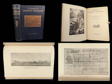
1899 American Privateers 1st/1st History Maritime REVOLUTIONARY War of 1812 NavySchilb Antiquarian Rare Books4.8(421)See Sold PriceMar 10, 2024
PR PAUL MCCOBB BRASS SIDE TABLES WITH GLASS TOPSThomaston Place Auction Galleries4.4(386)See Sold PriceFeb 25, 2024
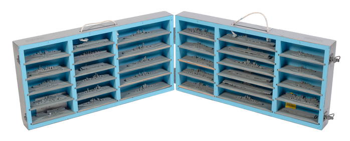
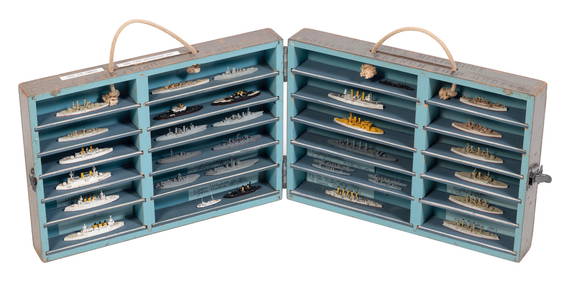
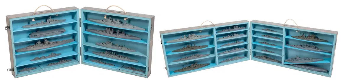
CASED SET OF WORLD WAR II-ERA U.S. NAVY RECOGNITION/TEACHING MODELS OF AMERICAN SHIPS 20th CenturyEldred's4.7(409)See Sold PriceFeb 27, 2024
CASED SET OF SHIP RECOGNITION/TEACHING MODELS First Half of the 20th Century Model lengths fromEldred's4.7(409)See Sold PriceFeb 27, 2024
TWO CASED SETS OF WORLD WAR II-ERA U.S. NAVY RECOGNITION/TEACHING MODELS OF BRITISH AND FRENCH SHIPSEldred's4.7(409)See Sold PriceFeb 27, 2024
FOUR CASED SETS OF WORLD WAR II-ERA U.S. NAVY RECOGNITION/TEACHING MODELS 20th Century Model lengthsEldred's4.7(409)See Sold PriceFeb 27, 2024
William Henry Harford (UK,1840-1917) watercolor painting antiqueBroward Auction Gallery4.8(277)See Sold PriceApr 14, 2024
Rand McNally Railroad Map Cabinet w/ 21 Railroad MapsRail & Road Auctions4.6(165)See Sold PriceMar 08, 2024
[ARCTIC]. BOWEN, Emanuel. A New & Accurate Map of the North...Potter & Potter Auctions4.6(539)See Sold PriceMar 07, 2024
Carey, pub. 1796 - Map of the Tennassee State formerly part of North Carolina (Tennessee)Trillium Antique Prints & Rare Books4.5(30)See Sold PriceFeb 24, 2024
West Indies. South Coast of Jamaica from Port Royal to Pedro Bluff.Jasper524.5(9.8k)See Sold PriceFeb 27, 2024
Map of Part of the West Indies, Etc., Showing the Exact Position Of The U.S. War Steamer SanJasper524.5(9.8k)See Sold PriceFeb 27, 2024


![[ARCTIC]. BOWEN, Emanuel. A New & Accurate Map of the North... (1 of 1)](https://p1.liveauctioneers.com/928/318880/171360917_1_x.jpg?height=282&quality=70&version=1707501302)