ATLAS of ANTIENT GEOGRAPHY by SAMUEL BUTLER 1843John McInnis Auctioneers,LLC4.6(504)See Sold PriceFeb 24, 2024
18TH C. ANTIQUE MAP: FRENCH & INDIAN WAR, FRAMEDThomaston Place Auction Galleries4.4(389)See Sold PriceFeb 24, 2024
Rand McNally Railroad Map Cabinet w/ 21 Railroad MapsRail & Road Auctions4.6(165)See Sold PriceMar 08, 2024
Keith Haring - Ink on New York Map, Best Buddies, Inscribed, Signed, and DatedSapphire Auction Gallery4.1(67)See Sold PriceMar 02, 2024
LATE 17TH C. FRENCH MAP OF THE NEW WORLD BY ALEXIS-HUBERT JAILLOT (1632-1712)Thomaston Place Auction Galleries4.4(389)See Sold PriceFeb 24, 2024
Central Railroad of New Jersey Map of Sandy Hook Route-ca. 1903JM Hobby Supply and Railroad Artifact Auctions4.4(126)See Sold PriceFeb 24, 2024
Lot of Six Mixed Atlas Box Cars-HO Scale-New in BoxJM Hobby Supply and Railroad Artifact Auctions4.4(126)See Sold PriceFeb 25, 2024
Rand McNally/Santa Fe Railroad Map of Iowa-1912JM Hobby Supply and Railroad Artifact Auctions4.4(126)See Sold PriceFeb 24, 2024
NICOLAES VISSCHER (NETHERLANDS, 1618-1709) MAP OF THE NEW WORLDThomaston Place Auction Galleries4.4(389)See Sold PriceFeb 24, 2024
17TH C. WORLD MAP BY NICOLAES VISSCHER (NETHERLANDS, 1618-1709)Thomaston Place Auction Galleries4.4(389)See Sold PriceFeb 24, 2024
Lot of Six Mixed Atlas Cabooses-HO Scale-New in BoxJM Hobby Supply and Railroad Artifact Auctions4.4(126)See Sold PriceFeb 25, 2024
Detailed maps of Panama's isthmus 1913Heading: (Panama) Author: Perry, W.L.G. Title: Two maps or Panama from the Isthmian Canal Commission Place Published: No place Publisher:U.S. Geological Survey Date Published: 1913 DescSee Sold Price
SoldBellin: Antique Map of Isthmus of Panama, 1754Title: Carte de l'Isthme de Panama et des Provinces de Veragua Terre Ferme et Darien. Detailed mid-18th century map of the Isthmus of Panama Map maker: Jacques Nicolas Bellin Place and Year: Paris, 17See Sold Price
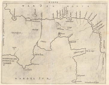
Sold[ANTIQUE MAP]Attractive vintage hand-colored copper engraved map depicting the Isthmus of Darien in Panama by William Hacke (1680-1710) and Robert Morden (1650-1703). Very detailed, captioned A New Map of ye IsthmSee Sold Price
Tallis / Rapkin: Antique Map of Panama Isthmus, 1849Title/Content of Map: 'Isthmus of Panama' The map indicates, in pink, five routes for "proposed railway and canal communications" connecting the Atlantic/Caribbean & Pacific oceans. Two of the proposeSee Sold Price
Tallis/Rapkin: Antique Map of Panama Isthmus, 1849Isthmus of Panama' The map indicates, in pink, five routes for "proposed railway and canal communications" connecting the Atlantic/Caribbean & Pacific oceans. Two of the proposed routes pass through PSee Sold Price
Tallis/Rapkin: Antique Map of the Panama Isthmus, 1849Isthmus of Panama' The map indicates, in pink, five routes for "proposed railway and canal communications" connecting the Atlantic/Caribbean & Pacific oceans. Two of the proposed routes pass through PSee Sold Price
SoldTallis, John (Pub) 1852 Map. Isthmus of PanamaSteel Engraved Map with Original Outline Hand Color Published 1852-56 by John Tallis, London for "The Universal Pronouncing Dictionary" by Thomas Wright. Drawn & Engraved by John Rapkin. Centre fold aSee Sold Price
PANAMA. Isthmus, Republic, Canal zone & profile. RANDTITLE/CONTENT OF MAP: 'Isthmus of Panama; Inset Republic of Panama; Profile of Canal' DATE PRINTED: 1912 IMAGE SIZE: Approx 34.0 x 27.0cm, 13.25 x 10.5 inches (Large) TYPE: Antique colour (color) atlaSee Sold Price
PANAMA ISTHMUS. 5 proposed canal/Rail routes.TITLE/CONTENT OF MAP: 'Isthmus of Panama' The map indicates, in pink, five routes for "proposed railway and canal communications" connecting the Atlantic/Caribbean & Pacific oceans. Two of the proposeSee Sold Price
PANAMA ISTHMUS. 5 proposed canal/RR routes. NicaraguaTITLE/CONTENT OF MAP: 'Isthmus of Panama' The map indicates, in pink, five routes for "proposed railway and canal communications" connecting the Atlantic/Caribbean & Pacific oceans. Two of the proposeSee Sold Price
PANAMA ISTHMUS. 5 proposed canal/RR routes. NicaraguaTITLE/CONTENT OF MAP: 'Isthmus of Panama' The map indicates, in pink, five routes for "proposed railway and canal communications" connecting the Atlantic/Caribbean & Pacific oceans. Two of the proposeSee Sold Price
PANAMA ISTHMUS. 5 proposed canal/RR routes. NicaraguaTITLE/CONTENT OF MAP: 'Isthmus of Panama' The map indicates, in pink, five routes for "proposed railway and canal communications" connecting the Atlantic/Caribbean & Pacific oceans. Two of the proposeSee Sold Price
North AmericaPublication Date: 1908 Title: North America Cartographer: RAND, MCNALLY & CO. Publisher: RAND, MCNALLY & CO. Height: 25.9 Width: 19 Detailed map of North America from Panama to Greenland. Details topoSee Sold Price
North AmericaTitle: North America Publication Date: 1908 Cartographer: RAND, MCNALLY & CO. Dimensions: 25.9Height - 19Width Publisher: RAND, MCNALLY & CO. Detailed map of North America from Panama to Greenland. DeSee Sold Price
PANAMA ISTHMUS. 5 proposed canal/RR routes. NicaraguaTITLE/CONTENT OF MAP: 'Isthmus of Panama' The map indicates, in pink, five routes for "proposed railway and canal communications" connecting the Atlantic/Caribbean & Pacific oceans. Two of the proposeSee Sold Price
North AmericaTitle/Content of Map: North America Date Printed: 1908 Cartographer: RAND, MCNALLY & CO. Size: 25.9X19 Detailed map of North America from Panama to Greenland. Details topography, countries, states, caSee Sold Price
SoldTirion: Antique Map of Isthmus of Panama, 1750Map: Kaart van de Landengte van Panama (Isthmus of Panama) Cartographer: Tirion Place & Date: Amsterdam / 1750 Size: 11 7/8" x 10 5/8" Condition: wash color; light overall age toning A beautifully desSee Sold Price
CARIBBEAN. West Indies and Central America; insetTITLE/CONTENT OF MAP: 'West Indies and Central America; Inset maps of Isthmus of Panama; The Nicaragua Route; Bermuda' DATE PRINTED: 1903 IMAGE SIZE: Approx 32.0 x 48.0cm, 12.5 x 18.75 inches (Large);See Sold Price
CARIBBEAN. West Indies and Central America; inset Panama Canal; Bermuda 1903 mapTITLE/CONTENT OF MAP: 'West Indies and Central America; Inset maps of Isthmus of Panama; The Nicaragua Route; Bermuda' DATE PRINTED: 1903 IMAGE SIZE: Approx 32.0 x 48.0cm, 12.5 x 18.75 inches (Large);See Sold Price
CARIBBEAN. West Indies and Central America; inset Panama Canal; Bermuda 1903 mapTITLE/CONTENT OF MAP: 'West Indies and Central America; Inset maps of Isthmus of Panama; The Nicaragua Route; Bermuda' DATE PRINTED: 1903 IMAGE SIZE: Approx 32.0 x 48.0cm, 12.5 x 18.75 inches (Large);See Sold Price
SoldTerra Firma et Novum Regnum Granatense et PopayanJan Janssonius (1588 - 1664). Amsterdam: Janssonius, c. 1636. 15 1/2 x 20 inches. Splendid map of the Isthmus of Panama and northwestern South America including most of present-day Colombia and part oSee Sold Price
Carte de lIsthme de Panama & des Provinces de Veragua'TITLE/CONTENT OF MAP: 'Carte de lIsthme de Panama et des Provinces de Veragua, Terre Ferme et Darien [Map of the Isthmus of Panama and the provinces of Veragua, Tierra Firme and Darien]' Panama and thSee Sold Price
Bradford: Post-Independence South America, 1835Description: The elegant, detailed map of newly liberated South America, from Panama to Tierra del Fuego, from Bradford's A Comprehensive Atlas, Geographical, Historical & Commercial, published by theSee Sold Price
Carte de lIsthme de Panama & des Provinces de Veragua'TITLE/CONTENT OF MAP: 'Carte de lIsthme de Panama et des Provinces de Veragua, Terre Ferme et Darien [Map of the Isthmus of Panama and the provinces of Veragua, Tierra Firme and Darien]' DATE PRINTED:See Sold Price
1764 Bellin Map of Southern Portion of Martinique -- Partie Meridionale de la MartiniqueJasper524.5(9.8k)See Sold PriceFeb 27, 2024
1834 Malte-Brun Map of the Caribbean -- West India IslandsJasper524.5(9.8k)See Sold PriceFeb 27, 2024
Vintage Boardwalk And Baseball Employee GuidesRapid Estate Liquidators and Auction Gallery4.5(1.1k)See Sold PriceFeb 28, 2024


![[ANTIQUE MAP] (1 of 1)](https://p1.liveauctioneers.com/135/23914/8572333_1_x.jpg?height=282&quality=70)