ATLAS of ANTIENT GEOGRAPHY by SAMUEL BUTLER 1843John McInnis Auctioneers,LLC4.6(502)See Sold PriceFeb 24, 2024
18TH C. ANTIQUE MAP: FRENCH & INDIAN WAR, FRAMEDThomaston Place Auction Galleries4.4(386)See Sold PriceFeb 24, 2024
Rand McNally Railroad Map Cabinet w/ 21 Railroad MapsRail & Road Auctions4.6(165)See Sold PriceMar 08, 2024
Keith Haring - Ink on New York Map, Best Buddies, Inscribed, Signed, and DatedSapphire Auction Gallery4(67)See Sold PriceMar 02, 2024
LATE 17TH C. FRENCH MAP OF THE NEW WORLD BY ALEXIS-HUBERT JAILLOT (1632-1712)Thomaston Place Auction Galleries4.4(386)See Sold PriceFeb 24, 2024
Central Railroad of New Jersey Map of Sandy Hook Route-ca. 1903JM Hobby Supply and Railroad Artifact Auctions4.4(126)See Sold PriceFeb 24, 2024
Lot of Six Mixed Atlas Box Cars-HO Scale-New in BoxJM Hobby Supply and Railroad Artifact Auctions4.4(126)See Sold PriceFeb 25, 2024
Rand McNally/Santa Fe Railroad Map of Iowa-1912JM Hobby Supply and Railroad Artifact Auctions4.4(126)See Sold PriceFeb 24, 2024
NICOLAES VISSCHER (NETHERLANDS, 1618-1709) MAP OF THE NEW WORLDThomaston Place Auction Galleries4.4(386)See Sold PriceFeb 24, 2024
17TH C. WORLD MAP BY NICOLAES VISSCHER (NETHERLANDS, 1618-1709)Thomaston Place Auction Galleries4.4(386)See Sold PriceFeb 24, 2024
Lot of Six Mixed Atlas Cabooses-HO Scale-New in BoxJM Hobby Supply and Railroad Artifact Auctions4.4(126)See Sold PriceFeb 25, 2024
SoldDe Wit Map of the German Holy Roman EmpireDE WIT, Frederick (c. 1630-1706). [Germany]. S.(acri) R.(omani) I.(mperii) in Germania Descriptio... Engraved map with original hand color. Amsterdam, c. 1690. 21 1/2" x 24 3/8" sheet. Antique map ofSee Sold Price
HOLY ROMAN EMPIRE. Europe. Otto the Great 962. Spread of Christianity 1902 mapTITLE OF THE MAP: 'Norwege' (De L'Europe) Baltic & Scandinavia DATE PRINTED: 1683 IMAGE SIZE: Approx Overall page size 13 x 21cm approximately (5 x 8 inches); image size 10.5 x 14.5cm approximately (4See Sold Price
SoldUnknown (German, 17th century), Map of the WurtzburgUnknown (German, 17th century), Map of the Wurtzburg Diocese of The Holy Roman Empire, c. 1669. No publisher's marks apparent. Written lower left '1669' in pencil. Hand tinted etching. 19" x 22".See Sold Price
Imperio d'Allemagna Holy Roman Empire. Germany &TITLE/CONTENT OF MAP: Imperio d'Allemagna diviso in dieci Cerchi quali Cerchi sono ne suoi principali stati. Il Regno di Boemia e le Provincie da esso dependenti [The Holy Roman Empire of the German NSee Sold Price
Sanson: Antique Map of Central Europe, 1645L'Allemagne par cercles [This title has been overlaid onto the original title of the map: "Carte Generale de l'Empire d'Allemagne et Pays Circonvoisins."]' The map depicts Greater Germany - The Holy RSee Sold Price
Sold1771 Wurttemberg German Holy Roman Empire Sattler COINS1771 Wurttemberg German Holy Roman Empire Sattler COINS Protestant Reformation Christian Sattler’s ‘History of the Duchy of Wurttemberg’ is a rare 18th-century historical account describing theSee Sold Price
Soldde Wit: Antique Map of Holy Land, 1680A beautifully designed and colored map of the Holy Land, divided by tribe, with a vignette of Jonah and the whale in the Mediterranean and many cities, towns, and topographical details throughout. AtSee Sold Price
De Wit: Antique Map of Holy Land with Jerusalem, 1680Title: Terra Sancta, sive Promissionis, olim Palestina Recens Delineata, et in Lucem Edita. 1680 De Wit map of the Holy Land with Jerusalem Map maker: Frederick de Wit, Atlas Minor Place and Year: AmsSee Sold Price
SoldRare map of the Holy Roman Empire, Germany, Austria,Title/Content of Map: Rare map of the Holy Roman Empire, Germany, Austria, Czech Rep with flags are countries on either side Date: 1717 Cartographer: Feuille Size: 7.6x10.6” Provenance: Amsterdam AdSee Sold Price
Rare map of the Holy Roman Empire, Germany, Austria,Reserve Reduced! Title/Content of Map: Rare map of the Holy Roman Empire, Germany, Austria, Czech Rep with flags are countries on either side Date: 1717 Size: 7.6x10.6” By Feuille. Hand colored. ResSee Sold Price
SoldMap of The Holy Roman Empire under Joseph Idated 1702; "Theatrum Belli Rhenani ...Ioseph I ..," {sic) engraved hand colored map by Johann Baptist Homann(1664-1724), 21 1/2 x 18 1/2 in., framed; Purchased from The Carson Clark Gallery, EdinburgSee Sold Price
1720 Map of the Holy Roman EmpireTitle: 1720 Map of the Holy Roman Empire Author: Homann Medium: Ink on Paper Dimensions: 20.5"X24" Description: Map of the Holy Roman Empire under Joseph the First. Engraved by John Baptiste Homann inSee Sold Price
1720 Map of the Holy Roman EmpireTitle: 1720 Map of the Holy Roman Empire Author: Homann Medium: Ink on Paper Dimensions: 20.5"X24" Description: Map of the Holy Roman Empire under Joseph the First. Engraved by John Baptiste Homann inSee Sold Price
RARE map of the Holy Roman Empire. (Germany)Title: RARE map of the Holy Roman Empire. (Germany) Date/Period: 1596 Materials: Copperplate engraved. Size: 14" x 10 1/4" Description: The 1596 edition of this map is different then his other publicaSee Sold Price
1741 antique MAP of HOLY ROMAN GERMANIC EMPIRE IMPERII ROMANO-GERMANICI 18th c.IMPERII ROMANO-GERMANICI HOLY ROMAN (GERMANIC) EMPIRE by Homann, Johann Baptist, 1663-1724 Nuremberg, 1741 Size 20.5 by 24" Good condition. Some wear, faded dampstains, small repairs at the margins ThSee Sold Price
RARE map of the Holy Roman Empire. (Germany)Title: RARE map of the Holy Roman Empire. (Germany) Date/Period: 1596 Materials: Copperplate engraved Size: 14" x 10 1/4" The 1596 edition of this map is different then his other publication of GermanSee Sold Price
RARE map of the Holy Roman Empire. (Germany)Title: RARE map of the Holy Roman Empire. (Germany) Description: The 1596 edition of this map is different then his other publication of Germany and is rarer. Decorated with a double headed eagle on tSee Sold Price
1741 antique MAP of HOLY ROMAN GERMANIC EMPIRE IMPERII ROMANO-GERMANICI 18th c.IMPERII ROMANO-GERMANICI HOLY ROMAN (GERMANIC) EMPIRE by Homann, Johann Baptist, 1663-1724 Nuremberg, 1741 Size 20.5 by 24" Good condition. Some wear, faded dampstains, small repairs at the margins -See Sold Price
RARE map of the Holy Roman Empire. (Germany)Title: RARE map of the Holy Roman Empire. (Germany) Date/Period: 1596 Materials: Copperplate engraved Size: 14" x 10 1/4" Description: The 1596 edition of this map is different then his other publicatSee Sold Price
RARE map of the Holy Roman Empire. (Germany)Title: RARE map of the Holy Roman Empire. (Germany) Date/Period: 1596 Materials: Copperplate engraved Size: 14" x 10 1/4" Description: The 1596 edition of this map is different then his other publicatSee Sold Price
1741 antique MAP of HOLY ROMAN GERMANIC EMPIRE IMPERII ROMANO-GERMANICI 18th c.IMPERII ROMANO-GERMANICI HOLY ROMAN (GERMANIC) EMPIRE by Homann, Johann Baptist, 1663-1724 Nuremberg, 1741 Size 20.5 by 24" Good condition. Some wear, faded dampstains, small repairs at the margins ThSee Sold Price
RARE map of the Holy Roman Empire. (Germany)Title: RARE map of the Holy Roman Empire. (Germany) Date/Period: 1596 Materials: Copperplate engraved Size: 14" x 10 1/4" Description: The 1596 edition of this map is different then his other publicatSee Sold Price
RARE map of the Holy Roman Empire. (Germany)Title: RARE map of the Holy Roman Empire. (Germany) Date/Period: 1596 Materials: Copperplate engraved Size: 14" x 10 1/4" The 1596 edition of this map is different then his other publication of GermanSee Sold Price
1741 antique MAP of HOLY ROMAN GERMANIC EMPIRE IMPERII ROMANO-GERMANICI 18th c.IMPERII ROMANO-GERMANICI HOLY ROMAN (GERMANIC) EMPIRE by Homann, Johann Baptist, 1663-1724 Nuremberg, 1741 Size 20.5 by 24" Good condition. Some wear, faded dampstains, small repairs at the margins ThSee Sold Price
EARLY 18TH C. DUTCH CHART OF PACIFIC OCEAN BY FREDERIK DE WIT (1629-1706) WITH CALIFORNIA AS ANThomaston Place Auction Galleries4.4(386)See Sold PriceFeb 24, 2024
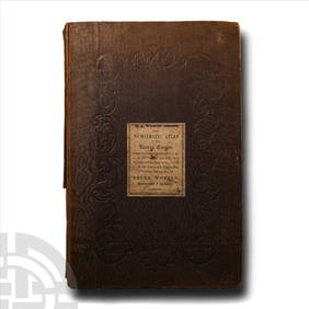
Numismatic Books - Whelan - The Numismatic Atlas of the Roman EmpireTimeLine Auctions Ltd.4.5(183)See Sold PriceMar 09, 2024
Numismatic Books - Whelan - The Numismatic Atlas of the Roman EmpireTimeLine Auctions Ltd.4.5(183)See Sold PriceMar 09, 2024
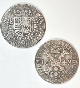
Dated 1649 Holy Roman Empire Large Silver tone CoinSouth Florida Auction & Estate Sale Services Inc4.5(520)See Sold PriceMar 08, 2024
Goltzius - 6 Etchings of Portraits of Holy Roman EmperorsTrillium Antique Prints & Rare Books4.5(30)See Sold PriceFeb 24, 2024
Map: A 17thC engraved and hand coloured map after Frederik de Wit (1630-1706) titled Nova Persiae,Claydon Auctioneers Ltd4.3(125)See Sold PriceFeb 26, 2024
MEDIEVAL EUROPEAN CONVERT’S CROSS NECKLACE, 9th-10th CENTURYJasper524.5(9.8k)See Sold PriceFeb 28, 2024
NORTHERN EUROPEAN CONVERT’S CROSS NECKLACE, 9th-10th CENTURYJasper524.5(9.8k)See Sold PriceFeb 28, 2024
HISTORICAL ANTIQUE, ELZEVIR HOLY ROMAN EMPIRE FERDINAND II (1637)NY Elizabeth 4.3(84)See Sold PriceMar 03, 2024