MAP - PIETER SCHENK / VALK / JANSSEN Hand Colored superb Map Central Italy c1702Luis Porretta Fine Arts4.3(10)See Sold PriceMar 02, 2024
CHARLES ROLLIN c1828 Ceasar Hand Colored Africa Military MapLuis Porretta Fine Arts4.3(10)See Sold PriceMar 02, 2024
MAP - Dufour, A. H. ( Malte / Brun ) :MAP - ESPAGNE PARTIE SUD DIVISEE EN PROVINCES ANCIENNES ( MAPLuis Porretta Fine Arts4.3(10)See Sold PriceMar 02, 2024
RIGOBERT BONNE c1787 Original Colored Map Germany & Region 15" x 12"Luis Porretta Fine Arts4.3(10)See Sold PriceMar 02, 2024
AMBROISE TARDIEU c1822 Napoleonic War Map GermanyLuis Porretta Fine Arts4.3(10)See Sold PriceMar 02, 2024
MAP - AMBROISE TARDIEU c1822 Napoleonic Miltary Map GermanyLuis Porretta Fine Arts4.3(10)See Sold PriceMar 02, 2024
1822 Rare Map by Ambroise Tardieu Napoleon Caldiero Battle of Vento 17" x 11Luis Porretta Fine Arts4.3(10)See Sold PriceMar 02, 2024
PIETER SCHENK / VALK / JANSSEN Hand Colored Map of Rhodes Greece ca1702 vgcLuis Porretta Fine Arts4.3(10)See Sold PriceMar 02, 2024
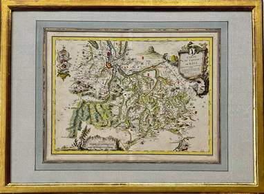
Map: Carte du Canton de Bale, Jacques Clermont, Paris, 1788Kensington Estate Auction4.6(216)See Sold PriceFeb 26, 2024
De L'isle, Map of Biblical Asia MinorTheatrum historicum ad annum Christi quadringentesimi in quo tu Imperii Romani tu Barbarorum... Guillaume De L'Isle (1675-1726). Engraved map with original color in outline. Paris, 1705. 20 x 26 3/4 iSee Sold Price
Military Map of Palestine, Asia and Syria - Fr...Asie Mineure et Syrie, Jerusalem Feuille Est, Reproduit et imprime au Service geographique de l'Armee pour les besoins exclusifs de l'Armee [Map of Asia Minor, Syria and East Jerusalem. Produced and pSee Sold Price
SoldGuillaume de L'isle 18th C. Map of Asia, NorthernAuthor: Guillaume de L'isle. Hand Colored Published in 1760 in de I'Isle/Pierre Mortier, Amsterdam "Carte de Tartarie Dressee sur les Relations deSee Sold Price
Antique Map - Asia - Hispaniola - Puerto Rico - Caribbean Island - after Jacques-Nicolas BellinThis hand-coloring map 'Carte de l'Isle d'Hayti, Aujour d'hui l'Espagnole, ou l'Isle de St. Domingue' originates from the Dutch edition of Bellin's Histoire General des Voyages. Size: 16.5” x 10See Sold Price
SoldUNFRAMED ANTIQUE MAP OF ASIA MINOR , HOMANN HEIRS, 1743"Carte de L'Asie Minevre ou de la Natolie et du Pont Evxin Tiree des Voyages et des Observations de Anciens et Modernes,...Heretiers de Homann. Nuremb.". Hand colored copperplate engraving. Unframed,See Sold Price
SoldTOBIAS CONRAD LOTTER ATLAS MAP OF ASIA, C.1770Framed antique map of Asia, cartographer Guillaume De L'Isle (French, 1675-1726), published by Tobias Conrad Lotter (German, 1717-1777) in "Atlas Novus Sive Tabulae Geographicae," engraved by Gustav CSee Sold Price
UNFRAMED ANTIQUE MAP OF ASIA MINOR , HOMANN HEIRS, 1743"Carte de L'Asie Minevre ou de la Natolie et du Pont Evxin Tiree des Voyages et des Observations de Anciens et Modernes,...Heretiers de Homann. Nuremb.". Hand colored copperplate engraving. Unframed,See Sold Price
SoldAsia.- De L'Isle (Guillaume) Carte d'Asie Dressee pourAsia.- De L'Isle (Guillaume) Carte d'Asie Dressee pour l'Usage du Roy sur les Memoires Envoyez par le Czar ..., detailed map of Asia showing from the Arabian Peninsula, across India, the Malay PeninsuSee Sold Price
Antique Map - South Asia - Map of Sri Lanka - after Jacques-Nicolas BellinThis hand-coloring map 'Carte de l'Isle de Ceylan' originates from the Dutch edition of Bellin's Histoire General des Voyages. Size: 16.5” x 12” inches / 42 cm x 31 cm. Technique: EngravinSee Sold Price
SoldLotter map, Asia, c.1770[Asia]. T. Conrad Lotter. Asia Concinnata Secundum Observationes Adademiae Regalis Scientiarum Et Nonnullas Alias, Et Juxta Annotationes Recentissimas Per G. de L'Lisle Geograph: Vanalis nunc proftatSee Sold Price
Soldengraved map, Guillaume de Lisle, AsiaFramed hand-colored engraved map, ''Carte d'Asie,'' by Guillaume de Lisle (French, 1675-1726), overall: 25''h x 30.5''wSee Sold Price
SoldDe Lisle (G) A Map of Turky, Arabia & PersiaDe L'isle (Guillaume) A Map of Turky, Arabia & Persia, engraved map with outline hand-colouring, 485 x 590mm., central vertical fold, central horizontal fold, a few minor marginal tears and haSee Sold Price
SoldDe l'Isle (G) Carte des Indes et De La ChineDe l'Isle (Guillaume) Carte des Indes et De La Chine, India, China, Japan and south east Asia, engraved map with original outline hand-colouring, 630 x 660mm., on two sheets, joined, central vSee Sold Price
SoldDe l'Isle (Guillaume) Carte des IndesDe l'Isle (Guillaume) Carte des Indes et de la Chine,south-east Asia, engraved map on 2 sheets joined, with original hand-colouring, 610 x 625mm., horizontal and vertical folds, some adjacentSee Sold Price
SoldFrench Map, G De L'isle, Americas, 1700MAP. G. de L'isle, Geographe, map of the Americas, hand colored print dated 1700, 17.5"h x 23.25"w (viewed), good condition, minor losses.See Sold Price
SoldRobert De Vaugndy Carte De L‘Asie [Asian Map]Robert de Vaugndy's (French 1688 - 1766) 'Carte De L‘Asie' ('Map of Asia'). Map features title cartouche. Measures 21.125-in. x 23.75-in. sheet size. In good condition with foxing and minor paper waSee Sold Price
Robert De Vaugndy Carte De L‘Asie [Asian Map]Robert de Vaugndy's (French 1688 - 1766) 'Carte De L‘Asie' ('Map of Asia'). Map features title cartouche. Measures 21.125-in. x 23.75-in. sheet size. In good condition with foxing and minor paper waSee Sold Price
Senex (John) A Map of Turkey, Arabia and PersiaSenex (John) A Map of Turkey, Arabia and Persia,map of the Middle East, based on the work of Guillaume De L'Isle, engraved map with hand-colouring, 470 x 480mm. (18 1/2 x 19 in), minor spottinSee Sold Price
SoldA mixed group of maps of India, East Asia, and RuA mixed group of maps of India, East Asia, and Russia,by Wyld, Cadell & Davies, de L'Isle, F.A. Garnier, Bonne, and many others, including a Chanlaire & Mentelle map of Russia in Europe, engrSee Sold Price
ANATOLIA 'Natolie' Asia Minor Turkey. Black Sea Cyprus Rhodes. MALLET 1683 mapTITLE OF THE MAP: 'Natolie' (De L'Asie) Shows the Black sea & Cyprus DATE PRINTED: 1683 IMAGE SIZE: Approx Overall page size 13 x 21cm approximately (5 x 8 inches); image size 10.5 x 14.5cm approximatSee Sold Price
ASIA MINOR. 'Asie Mineure'. Turkey. Ancient Anatolia. Black Sea. MALLET 1683 mapTITLE OF THE MAP: 'Asie Mineure' (De L'Asie) DATE PRINTED: 1683 IMAGE SIZE: Approx Overall page size 13 x 21cm approximately (5 x 8 inches); image size 10.5 x 14.5cm approximately (4 x 5.5 inches) TYPSee Sold Price
SoldDe Vaugondy map of Southern Asia 1761Title: Indostan, Presqu'Isles de l'Inde Chine, Tartarie Independante Author: De Vaugondy, Robert Description: Copper-engraved map, hand-colored in outline. 23.7x28 cm. (9½x11").Southern half of AsiaSee Sold Price
Carte de Tartarie Dressee sur les Relations de PlAuthor: De l'Isle, Guillaume Copper-engraved map, hand-colored in outline; uncolored pictorial cartouche. 49.5x61.5 cm. (18¾x24"); matted and framed under plexiglass. Asia from Afghanistan, Tibet andSee Sold Price
Map of the World. Turkey, Arabia, and Persia. GuillaumeCarte de la Turquie de l'Arabie et de la Perse. Detailed map of the Holy Land, Turkey, Asia Minor, Africa. By Guillaume de l'lse. Paris, 1701. Copperplate engraving. Black and whtie. Engraver's name iSee Sold Price
Map of St. Kitts and Nevis Depot de la Marine, Paris, 1758Global Auctions Company4.3(36)See Sold PriceMar 03, 2024
Chatelain - Map of the Americas and Details and Insets of Government CounselsTrillium Antique Prints & Rare Books4.5(30)See Sold PriceFeb 24, 2024
Chatelain - 3 Maps of the British Isles (England, Ireland, Scotland)Trillium Antique Prints & Rare Books4.5(30)See Sold PriceFeb 24, 2024
1760 MAP CARTE PARTICULIERE DE L'ISLE DE JUAN FERNANDES antique Robinson CrusoeJasper524.5(9.8k)See Sold PriceFeb 27, 2024
1764 Bellin Map of Eastern Guadeloupe in the Lesser Antilles -- Partie Orientale de l'Isle de laJasper524.5(9.8k)See Sold PriceFeb 27, 2024
1764 Bellin Map of Mari-Galante Near Guadeloupe -- Carte de l'Isle de Mari-GalanteJasper524.5(9.8k)See Sold PriceFeb 27, 2024
1764 Bellin Map of St. Kitts -- Carte de l'Isle St. ChristopheJasper524.5(9.8k)See Sold PriceFeb 27, 2024
1764 Bellin Map of Western Guadeloupe in the Lesser Antilles -- Partie Occidentale de l'Isle de laJasper524.5(9.8k)See Sold PriceFeb 27, 2024
1764 Bellin Map of Antigua -- Carte de l'Isle d'Antigue Situee par la Latitude 17 Degres et par laJasper524.5(9.8k)See Sold PriceFeb 27, 2024
1845 Delisle/Bauche Map of Martinique -- Carte de l'Isle de la Martinique Colonie Francoise de l'uneJasper524.5(9.8k)See Sold PriceFeb 27, 2024
Carte du Canal de Mosambique…. Madagascar Bonne Esperance. BONNE 1780 mapJasper524.5(9.8k)See Sold PriceFeb 28, 2024
Le Canal de Mosambique, l'Isle de Madagascar… Mozambique. Africa. BONNE 1788 mapJasper524.5(9.8k)See Sold PriceFeb 28, 2024
Le Canal de Mosambique, l'Isle de Madagascar… Mozambique. Africa. BONNE 1790 mapJasper524.5(9.8k)See Sold PriceFeb 28, 2024
Map of the Count of Flanders, 1700 by Gillaume de Lisle, ParisAntiques Online Auctions4.6(407)See Sold PriceMar 14, 2024
Map of Turkey from Arabic and Persia, 1701 by Gillaume de Lisle, ParisAntiques Online Auctions4.6(407)See Sold PriceMar 14, 2024
Antique Map of Poland, 1700 by Guillaume De Lisle, ParisAntiques Online Auctions4.6(407)See Sold PriceMar 14, 2024
Antique Map of France, 1703 by Gillaume Del Isle PrintAntiques Online Auctions4.6(407)See Sold PriceMar 14, 2024


![Robert De Vaugndy Carte De L‘Asie [Asian Map] (1 of 3)](https://p1.liveauctioneers.com/5755/151531/76497302_1_x.jpg?height=282&quality=70&version=1570046172)
![Robert De Vaugndy Carte De L‘Asie [Asian Map] (1 of 3)](https://p1.liveauctioneers.com/5755/147592/74586085_1_x.jpg?height=282&quality=70&version=1565308571)


