ATLAS of ANTIENT GEOGRAPHY by SAMUEL BUTLER 1843John McInnis Auctioneers,LLC4.6(502)See Sold PriceFeb 24, 2024
18TH C. ANTIQUE MAP: FRENCH & INDIAN WAR, FRAMEDThomaston Place Auction Galleries4.4(386)See Sold PriceFeb 24, 2024
Rand McNally Railroad Map Cabinet w/ 21 Railroad MapsRail & Road Auctions4.6(165)See Sold PriceMar 08, 2024
Keith Haring - Ink on New York Map, Best Buddies, Inscribed, Signed, and DatedSapphire Auction Gallery4(67)See Sold PriceMar 02, 2024
LATE 17TH C. FRENCH MAP OF THE NEW WORLD BY ALEXIS-HUBERT JAILLOT (1632-1712)Thomaston Place Auction Galleries4.4(386)See Sold PriceFeb 24, 2024
Central Railroad of New Jersey Map of Sandy Hook Route-ca. 1903JM Hobby Supply and Railroad Artifact Auctions4.4(126)See Sold PriceFeb 24, 2024
Lot of Six Mixed Atlas Box Cars-HO Scale-New in BoxJM Hobby Supply and Railroad Artifact Auctions4.4(126)See Sold PriceFeb 25, 2024
Rand McNally/Santa Fe Railroad Map of Iowa-1912JM Hobby Supply and Railroad Artifact Auctions4.4(126)See Sold PriceFeb 24, 2024
NICOLAES VISSCHER (NETHERLANDS, 1618-1709) MAP OF THE NEW WORLDThomaston Place Auction Galleries4.4(386)See Sold PriceFeb 24, 2024
17TH C. WORLD MAP BY NICOLAES VISSCHER (NETHERLANDS, 1618-1709)Thomaston Place Auction Galleries4.4(386)See Sold PriceFeb 24, 2024
Lot of Six Mixed Atlas Cabooses-HO Scale-New in BoxJM Hobby Supply and Railroad Artifact Auctions4.4(126)See Sold PriceFeb 25, 2024
de Fer Plan du Port du Passage en Espagne'.TITLE/CONTENT OF MAP: 'Plan du Port du Passage en Espagne, située dans la province de Biscaye sur l'Ocean entre Fontarabie et St Sebastien [Plan of the Bay of Pasaia in Spain, situated the province oSee Sold Price
"Plan du Port du Passage en Espagne" Bay of Pasaia,Enmarcado y buena presentación. Discipline: Pintura Authorship: NICOLAS DE FER (Francia, 1646-1720) Company: De Fer Technique: Grabado Coloreado/Papel Measurements:<See Sold Price
Nicolas de Fer (1646-1720) Tre mappe da pareteIncisione su carta su tela A) Plan du Port du Passage en Espagne, 1705, cm. 25,5x35 B) Carmagnole, 1705, cm. 25,5x35 C) Siracuse ou Siracous, 1693, cm. 25,5x35See Sold Price
Plan du Port du Passage en Espagne'. Bay of Pasaia,TITLE/CONTENT OF MAP: 'Plan du Port du Passage en Espagne, située dans la province de Biscaye sur l'Ocean entre Fontarabie et St Sebastien [Plan of the Bay of Pasaia in Spain, situated the province oSee Sold Price
Plan du Port du Passage en Espagne'. Bay of Pasaia,TITLE/CONTENT OF MAP: 'Plan du Port du Passage en Espagne, située dans la province de Biscaye sur l'Ocean entre Fontarabie et St Sebastien [Plan of the Bay of Pasaia in Spain, situated the province oSee Sold Price
SoldLa Perouse: Map of Port of San Diego, 1797Map: Plan du Port de St. Diego en Californie/Plan du Port et du Department de St. Blas Cartographer: La Perouse Place & Date: Paris / 1797 Size: 19 1/2" x 13 1/4" Plate 35 from the Atlas volume of LaSee Sold Price
De Fer: Antique Town Plans of Marseille, 1705Title: Lentreé du Port de Marseille, et le Plan de la Citadelle et du Fort de St Jean.... Map maker: Nicolas de Fer Place and Year: Paris, 1705 Dimensions: Plan 1: 28 x 36 cm (11 x 14.2 in); Plan 2:See Sold Price
SoldJean de Beaurain Map of Port Mahon SpainPlan de la Ville et du Port Mahon et du Fort St. Philippe Tel qu'il etoit Fortifie en 1706 par les Espagnols, Paris France, mid 18th Century. a two-page map with good margins and some edge handling. HSee Sold Price
SoldGreece 1824 Pair of Maps by Barthelemy"Plan du Passage des Thermopyles" and "Plan de la Bataille de Marathon" Copper Engraved Maps Published 1824, Paris for "Voyage du Jeune Anacharsis en Grece" by Jean Jacques Barthelemy. Paper Size: 13.See Sold Price
SoldNicolas De Fer: Carte Generale du Globe Terrestre, 1705Map: Carte Generale du Globe Terrestre et Aquatiques ou Mappemonde en Deux Plans-Hemisphere [Scarce 1705 antique map with California as an island] Maker: Nicolas De Fer Size: 8.125 x 11.125 (10.25 x 1See Sold Price
SoldFrench Chart of San Diego 1797Heading: (California) Author: La Perouse, Jean François Galaup de. Title: Plan du Port de St. Diego en Californie situé par 32o 39" 0' de latitude Nord et 12o 4' 0" à l'Ouest de St. Blas Levé en 1See Sold Price
SoldLa Perouse plan of San Diego harborTitle: Plan du Port de St. Diego en Californie situé par 32o 39" 0' de latitude Nord et 12o 4' 0" à l'Ouest de St. Blas Levé en 1782 Author: La Perouse, Jean François Galaup de Description: CopperSee Sold Price
Ayrouard (Jacques) - A group of 4 coastal charts forincluding Plan du Golfe et des Caps de St Tropez, Plan de la Baye de Gourien, Plan du Port d'Antibe, Plan de la Baye et Port to Toulon, engraved charts by Louis Corne, each c.310 x 465mm., each with aSee Sold Price
Terre de Kerguelen Isle de la Désolation. KerguelenTITLE/CONTENT OF MAP: [Cook 3e Voyage] Terre de Kerguelen, appellée par M . Cook Isle de la Désolation // Plan du Port Palliser dans la Terre de Kerguelen // Plan du Havre de Noël dans la Terre deSee Sold Price
SoldCOVENS and MORTIER. Plan du Port de la Ville eCOVENS and MORTIER. Plan du Port de la Ville et des Forteresses de Carthagene. Double-page engraved town plan, 510x600 mm, wide margins; inked number at top of map (easily matted out). Amsterdam, 1741See Sold Price
SoldBellin (J N) Plan du Port de LisbonneBellin (Jacques Nicolas) Plan du Port de Lisbonne et des Costes Voisines,Lisbon and environs, with panorama of the city above, decorative title cartouche, inset plan of Lisbon, engraved chart,See Sold Price
Port du Port Mulgrave. No 22. & Plan du port de la ...Port du Port Mulgrave. No 22. & Plan du port de la Nouvelle Archangel dans L;Isle de Sitka Capitale des Establissements de L'Amerique. From Eugene Duflot de Mofras’s Exploration Du Territoire De L��See Sold Price
SoldJules DEFER (1803-1902), attribué à Vue du port de NiceJules DEFER (1803-1902), attribué à Vue du port de Nice au loin Mine de plomb, lavis et rehauts de gouache sur papier 9 x 13 cmSee Sold Price
Jules DEFER (1803-1902), attribué à Vue du port de NiceJules DEFER (1803-1902), attribué à Vue du port de Nice au loin Mine de plomb, lavis et rehauts de gouache sur papier 9 x 13 cmSee Sold Price
Jules DEFER (1803-1902), attribué à Vue du port deJules DEFER (1803-1902), attribué à Vue du port de Nice au loin Mine de plomb, lavis et rehauts de gouache sur papier 9 x 13 cmSee Sold Price
SoldTRAVEL POSTER1920 CHEMINS DE FER DU MIDI ET DU NORD DEL ESPAGNE SARAGOSSE TRAVEL POSTER BY E. PAUL CHAMOESIX PRINTED BY LUCIEN SERRE IMP PARIS. EDGE TEARS. 24 INCHES X 39 INCHES. All property is sold "AS IS", "WHESee Sold Price
Port de Quadra ou De La Decouverta. No. 19. & Plan duPort de Quadra ou De La Decouverta. No. 19. & Plan du Port de Nutka Cala de Los Amigoes. No. 20. From Eugene Duflot de Mofras’s Exploration Du Territoire De L’Oregon, Des Californies Et De La MerSee Sold Price
SoldLa Perouse (J-F. G de) Port de Bucarelli, sur laLa Perouse (Jean Francois Galaup de) Plan de L'Entrée du Port de Bucarelli, sur la Côte du Nord-Ouest de l'Amérique, engraved map with hand-colouring, central vertical fold, central horizontalSee Sold Price
Port de L’Embouchure Du Rio Colorado dans le Mer...Port de L’Embouchure Du Rio Colorado dans le Mer Veermeille. No. 10. & Plan du Port de S. Diego situe sur la cote Septentrionale de la California. No. 11. From Eugene Duflot de Mofras’s ExploratioSee Sold Price
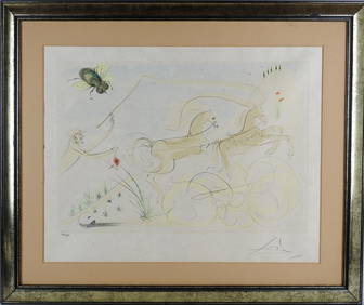
Salvador DALI (1904-1989) d'après : Le coche et la mouche du Bestiaire de la fontaine Dalinisée.Valoir Pousse-Cornet4.3(4)See Sold PriceFeb 24, 2024
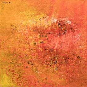
SAVANN THAV (artiste cambodgien né en 1956) : Composition au fond rouge jaune et rouge. Toile. 100Valoir Pousse-Cornet4.3(4)See Sold PriceFeb 24, 2024
Pierre CHAREAU (1883-1950) Table de salle à manger variante du modèle MB97 en placage et bois deValoir Pousse-Cornet4.3(4)See Sold PriceFeb 24, 2024
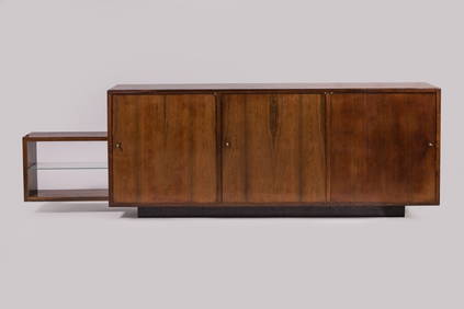
Pierre CHAREAU (1883-1950) Enfilade moderniste variante du modèle MA 788 à caisson cubiqueValoir Pousse-Cornet4.3(4)See Sold PriceFeb 24, 2024
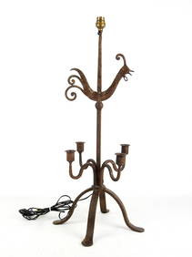
LES ARTISANS DE MAROLLES ET DU LOIR ET CHER (dans le goût de) : Lampadaire tripode en fer forgé àValoir Pousse-Cornet4.3(4)See Sold PriceFeb 24, 2024
LES ARTISANS DE MAROLLES ET DU LOIR ET CHER (dans le goût de) : Candélabre en fer forgé à cinqValoir Pousse-Cornet4.3(4)See Sold PriceFeb 24, 2024
Olivier de SCHRIJVER (né en 1958) : Miroir " Souvenirs de Venise ", l'arrière du miroir enValoir Pousse-Cornet4.3(4)See Sold PriceFeb 24, 2024
D'Entrecasteaux - Tasmania, Australia: Map of the Northern Portion of Recherche Bay. 5Trillium Antique Prints & Rare Books4.5(30)See Sold PriceFeb 24, 2024
D'Entrecasteaux - Australia: Chart of Van Diemen's Land (New Holland). 3Trillium Antique Prints & Rare Books4.5(30)See Sold PriceFeb 24, 2024
D'Entrecasteaux - Map of Australia (New Holland), New Zealand, and southern Asia and surroundingTrillium Antique Prints & Rare Books4.5(30)See Sold PriceFeb 24, 2024
Jules Verne, Le Tour du Monde/Le Doctor Ox, Aux HarponsLion and Unicorn4.7(1.8k)See Sold PriceMar 03, 2024
Plan du Portendic, appellé aussi…' Portendick Mauritania. BELLIN 1746 old mapJasper524.5(9.8k)See Sold PriceFeb 28, 2024
NORTH AFRICA. 'Biledulgerid', a former North African country. MALLET 1683 mapJasper524.5(9.8k)See Sold PriceFeb 28, 2024
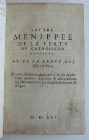
OLD SATIRICAL WORK, 1595 SATYRE MENIPPEE DE LA VERTU DU CATHOLICON D'ESPAGNENY Elizabeth 4.3(84)See Sold PriceMar 03, 2024
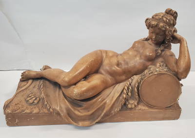
Nicot, Rene (XIX-XX) French, Nymphe allongee a la cymbaleGaia Auctions4.4(65)See Sold PriceMar 04, 2024