SoldCYPRUS INSULA. [Ca 1630s-40s]. Map.[Mediterranean] CYPRUS INSULA. [C. 1630s-40s.] Double-page map by Bleau (or by Jansson after Bleau), after an earlier map by Ortelius. Shows the locations of towns on the Eastern Mediterranean island.See Sold Price
SoldCenomanorum Galliae regionis typus. [Ca 1630s-40s][Blaeu/France]. Cenomanorum Galliae regionis typus: Vulgo Le Mans. Double-page map showing the area to the south of Normandy, north of Touraine, and to the west of Brittany. Over 2 dozen locations beaSee Sold Price
SoldOrtelius Map of Crete and Cyprus ca. 1570sAbraham Ortelius (1527–1598), "Cyprus Insula; Candia, Olim Creta," from "Theatrum Orbis Terrarum," Antwerp: Ortelius, ca. 1570s. Hand colored map of Cyprus and Crete, with each island shown sepSee Sold Price
Sold[Blaeu (Johan & Willem)] Cyprus Insula[Blaeu (Johan & Willem)] Cyprus Insula,map of the island of Cyprus from, and with the bound text of, the Asia et Sina vol. of the Theatrum Orbis Terrarum (incorporating the text, only, of theSee Sold Price
Blaeu (Johan). Cyprus InsulaBlaeu (Johan) Cyprus Insula,map of Cyprus, with a decorative cartouche in lower right of Aphrodite sailing towards Paphos drawn by swans, hand-coloured engraving, 385 x 500mm., Latin text on vSee Sold Price
SoldOrtelius Antique Map: Cyprus Insula, Candia Olim CretaTitle/Content of Map: Cyprus Insula, Candia Olim Creta Date Printed: 1579 Cartographer: Abraham Ortelius Material/Medium: No color, good impression. Latin text on verso. From the first modern atlas- tSee Sold Price
SoldTabula Islandiae..., map, [ca. 1630's - 1660's].[Bleau]. Tabula Islandiae Auctore Georgio Carolo Flandro. Amst: William Bleau, (nd), [ca. 1635 – 1662]. 14 7/8” x 19 5/8”. Later hand-colored outline, w/ coloring of cartouche and scale. Minor fSee Sold Price
SoldBlome Map of Cyprus Insula & Candia Olim Creta 14Blome coloured engraving Map of Cyprus Insula & Candia Olim Creta 14.5 x 17in.See Sold Price
Sold2 Maps incl: Aestivarum Insulae... [ca 1680-1700].[Colonial US/Bermuda]. 2 Maps. ++ Aestivarum Insulae at Barmudas. Marks locations of 11 forts, with letters corresponding to a key at lower left. A derivative of John Speed’s map (of 1627), this marSee Sold Price
Sold1690 Coronelli Map of Cyprus -- Acamantis InsulaTitle/Content of Map: 1690 Coronelli Map of Cyprus -- Acamantis Insula hoggidi Cipro, Posseduta dalla Republica Veneta sin'all'Anno 1571 Date: 1690 c., Venice Cartographer: V Coronelli Size: 18.1 X 24See Sold Price
SoldOrtelius: Map of Cyprus, 1575Map: 1575 Ortelius Map of Cyprus -- Cypri Insulae Nova De Script 1575 Cartographer: A. Ortelius Year / Place: 1575 Antwerp Map Dimensions: 14 x 20 in. This unique and very interesting map of Cyprus isSee Sold Price
SoldMediterranean.- Cyprus & Crete.- Ortelius (Abraham)NO RESERVE Mediterranean.- Cyprus & Crete.- Ortelius (Abraham) Cyprus Insula [on sheet with] Candia, olim Creta, map of Cyprus and Crete on one sheet, one above the other, only printed in Theatrum OrbSee Sold Price
SoldBlaeu map of Cyprus c.1640Heading: Author: Blaeu, Willem Title: Cyprus Insula Place Published: Amsterdam Publisher: Date Published: c.1640 Description: Copper-engraved map, hand-colored in outline,See Sold Price
Blaeu map of Cyprus c.1640Heading: Author: Blaeu, Willem Title: Cyprus Insula Place Published: Amsterdam Publisher: Date Published: c.1640 Description: Copper-engraved map, hand-colored in outline,See Sold Price
SoldYucatan Conventus... Guatimala... ca 1630's - 169[Central America]. [Ogilby]. Yucatan Conventus Juridici Hispaniae Novae Pars Occidentalis, Et Guatimala Conventus Juridicus. Double-page engraved map of central America, including large portions of MeSee Sold Price
SoldOrtelius, Abraham. Cyprus Insula with Candia Olimcopperplate engraving with hand color on a single sheet from Theatrum Orbis Terrarum (Antwerp,1570s), Latin text en verso, page 51, pencil notation to lower front margin dating the map to 1573. UnframSee Sold Price
MAP, Cyprus, Ortelius/GalleCyprus. Ortelius/Galle, Cyprus Insula, from Le Miroir du Monde, 1579 (published). Hand Color. This tiny map is a charming depiction of the island showing the rivers and cities. The island is surroundeSee Sold Price
SoldBlaeu (Johan & Willem) Cyprus InsulaBlaeu (Johan & Willem) Cyprus Insula,Cyprus with vignette title of Aphrodite sailing towards Paphos drawn by swans, lower right, compass rose, arms and ships, engraved map with hand-coloured,See Sold Price
MAP, Cyprus & Crete, OrteliusCyprus & Crete. Abraham Ortelius, Cyprus Insula [on sheet with] Candia, olim Creta, from Theatrum Orbis Terrarum, 1574 (published). Hand Color. This folio sheet contains maps of Cyprus and Crete one aSee Sold Price
SoldOrtelius, Abraham. Cyprus Insula with Candia Olimcopperplate engraving with hand color on a single sheet from Theatrum Orbis Terrarum (Antwerp, 1570s), French text en verso; presented in gilt wooden frame. DOA 22.75 x 25.75 in.; SS 15 x 18 in. A SinSee Sold Price
SoldOrtelius, Abraham. Cyprus Insula with Candia Olimcopperplate engraving on a single sheet from Theatrum Orbis Terrarum (Antwerp, 1570s), French text en verso. Presented in gilt wooden frame. DOA 22.75 x 25.75 in. A Single-Owner Collection of CypriotSee Sold Price
SoldOrtelius (Abraham) Cyprus Insula [on sheet with] COrtelius (Abraham) Cyprus Insula [on sheet with] Candia, olim Creta,2 maps of Cyprus and Crete, on one plate, Cyprus with strapwork cartouche and two small ships, engraving, 370 x 440mm., LatiSee Sold Price
SoldZypern.Cyprus insula. Karte der Insel, darunter Leiste mit 6 kl. Karten griech. Inseln (Chios, Rhodos etc.). Kupferstichkarte, 1632. Blattgröße 16,5 x 21 cm. Aus: Atlas sive cosmographicae meditatiSee Sold Price
Colored copper etching Kingdoms Siciliae Insulae MaltaeColored copper etching Kingdoms Siciliae Insulae Maltae et Gozae, 1680 ca. Rare and beautiful map of Sicily and surrounding islands. The Danckerts family, three generations of printers and cartographeSee Sold Price
Vintage Ca. 1940's International Panel Delivery Truck Converted into Stationary Food Truck, WasSwisher Bros. Auction LLC4.4(251)See Sold PriceFeb 25, 2024
Chicago Milwaukee and St Paul RY Panama Pacific Exposition Brochure-1915JM Hobby Supply and Railroad Artifact Auctions4.4(126)See Sold PriceFeb 24, 2024
LARGE LATE 17TH C. DUTCH CHART OF CANADA, GREAT LAKES, NEW FRANCE, LABRADOR, HUDSON BAY, BY PIERREThomaston Place Auction Galleries4.4(389)See Sold PriceFeb 24, 2024
EARLY 18TH C. DUTCH CHART OF PACIFIC OCEAN BY FREDERIK DE WIT (1629-1706) WITH CALIFORNIA AS ANThomaston Place Auction Galleries4.4(389)See Sold PriceFeb 24, 2024
EARLY 18TH C. MAP OF ITALY, FRAMEDThomaston Place Auction Galleries4.4(389)See Sold PriceFeb 24, 2024
LATE 16TH C. MAP OF SCOTLAND BY MERCATOR, FRAMEDThomaston Place Auction Galleries4.4(389)See Sold PriceFeb 24, 2024
[ARCTIC]. BOWEN, Emanuel. A New & Accurate Map of the North...Potter & Potter Auctions4.6(544)See Sold PriceMar 07, 2024
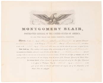
SOMERSET, Lord Charles (1767-1831) and BLAIR, Montgomery (1...Potter & Potter Auctions4.6(544)See Sold PriceMar 07, 2024
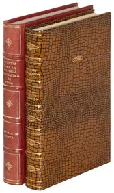
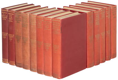
[MAPS]. DUFOUR, Auguste-Henri (1795-1865). Bound Volume of ...Potter & Potter Auctions4.6(544)See Sold PriceMar 07, 2024
[MAP]. [ALBRIZZI, Giambatista, 1698-1777]. Carta Geografica...Potter & Potter Auctions4.6(544)See Sold PriceMar 07, 2024
[MAP]. NICHOLLS, Sutton (1668-1729). An Epitome of Sr. Will...Potter & Potter Auctions4.6(544)See Sold PriceMar 07, 2024
[BUSINESS]. Travel Guide of Negro Hotels and Guest Houses. Published by Afro-American Newspapers ofFreeman's | Hindman4.4(1.6k)See Sold PriceFeb 27, 2024
Fifteen American Fiddleback Coin Silver Spoons by Various MakersGray's Auctioneers4.5(187)See Sold PriceMar 06, 2024
![CYPRUS INSULA. [Ca 1630s-40s]. Map. First Image](https://p1.liveauctioneers.com/179/96603/49249191_1_x.jpg?height=282&quality=95&version=1479429231&width=282)
![CYPRUS INSULA. [Ca 1630s-40s]. Map. (1 of 3)](https://p1.liveauctioneers.com/179/96603/49249191_1_x.jpg?height=282&quality=70&version=1479429231)
![CYPRUS INSULA. [Ca 1630s-40s]. Map. First Image](https://p1.liveauctioneers.com/179/96603/49249191_1_x.jpg?height=282&quality=1&version=1479429231&width=282)
![Cenomanorum Galliae regionis typus. [Ca 1630s-40s] (1 of 2)](https://p1.liveauctioneers.com/179/41615/18011172_1_x.jpg?height=282&quality=70&version=1369948904)

![[Blaeu (Johan & Willem)] Cyprus Insula (1 of 1)](https://p1.liveauctioneers.com/410/10165/2289091_1_x.jpg?height=282&quality=70)


![Tabula Islandiae..., map, [ca. 1630's - 1660's]. (1 of 9)](https://p1.liveauctioneers.com/179/47316/21802719_1_x.jpg?height=282&quality=70&version=1383851649)

![2 Maps incl: Aestivarum Insulae... [ca 1680-1700]. (1 of 4)](https://p1.liveauctioneers.com/179/49347/23134455_1_x.jpg?height=282&quality=70&version=1388425910)


![Ortelius (Abraham) Cyprus Insula [on sheet with] C (1 of 1)](https://p1.liveauctioneers.com/410/22701/7943958_1_x.jpg?height=282&quality=70)


![[ARCTIC]. BOWEN, Emanuel. A New & Accurate Map of the North... (1 of 1)](https://p1.liveauctioneers.com/928/318880/171360917_1_x.jpg?height=282&quality=70&version=1707501302)
![[MAPS]. DUFOUR, Auguste-Henri (1795-1865). Bound Volume of ... (1 of 2)](https://p1.liveauctioneers.com/928/318880/171361279_1_x.jpg?height=282&quality=70&version=1707501302)
![[MAP]. [ALBRIZZI, Giambatista, 1698-1777]. Carta Geografica... (1 of 1)](https://p1.liveauctioneers.com/928/318880/171361280_1_x.jpg?height=282&quality=70&version=1707501302)
![[MAP]. NICHOLLS, Sutton (1668-1729). An Epitome of Sr. Will... (1 of 1)](https://p1.liveauctioneers.com/928/318880/171361281_1_x.jpg?height=282&quality=70&version=1707501302)
![[BUSINESS]. Travel Guide of Negro Hotels and Guest Houses. Published by Afro-American Newspapers of (1 of 4)](https://p1.liveauctioneers.com/197/319238/171467937_1_x.jpg?height=282&quality=70&version=1707520367)