ATLAS of ANTIENT GEOGRAPHY by SAMUEL BUTLER 1843John McInnis Auctioneers,LLC4.6(502)See Sold PriceFeb 24, 2024
18TH C. ANTIQUE MAP: FRENCH & INDIAN WAR, FRAMEDThomaston Place Auction Galleries4.4(386)See Sold PriceFeb 24, 2024
Rand McNally Railroad Map Cabinet w/ 21 Railroad MapsRail & Road Auctions4.6(165)See Sold PriceMar 08, 2024
Keith Haring - Ink on New York Map, Best Buddies, Inscribed, Signed, and DatedSapphire Auction Gallery4(67)See Sold PriceMar 02, 2024
LATE 17TH C. FRENCH MAP OF THE NEW WORLD BY ALEXIS-HUBERT JAILLOT (1632-1712)Thomaston Place Auction Galleries4.4(386)See Sold PriceFeb 24, 2024
Central Railroad of New Jersey Map of Sandy Hook Route-ca. 1903JM Hobby Supply and Railroad Artifact Auctions4.4(126)See Sold PriceFeb 24, 2024
Lot of Six Mixed Atlas Box Cars-HO Scale-New in BoxJM Hobby Supply and Railroad Artifact Auctions4.4(126)See Sold PriceFeb 25, 2024
Rand McNally/Santa Fe Railroad Map of Iowa-1912JM Hobby Supply and Railroad Artifact Auctions4.4(126)See Sold PriceFeb 24, 2024
NICOLAES VISSCHER (NETHERLANDS, 1618-1709) MAP OF THE NEW WORLDThomaston Place Auction Galleries4.4(386)See Sold PriceFeb 24, 2024
17TH C. WORLD MAP BY NICOLAES VISSCHER (NETHERLANDS, 1618-1709)Thomaston Place Auction Galleries4.4(386)See Sold PriceFeb 24, 2024
Lot of Six Mixed Atlas Cabooses-HO Scale-New in BoxJM Hobby Supply and Railroad Artifact Auctions4.4(126)See Sold PriceFeb 25, 2024
SoldAntique Map - Cuba & The Bahama Islands - 1889Antique Map - Cuba & The Bahama Islands - 1889 from Cram's Atlas 1889. Size : 14.5" x 11"See Sold Price
Cuba & The Bahama Islands 1889Title/Content: Cuba & The Bahama Islands 1889 Date:1889 Material: paper Dimensions: approx. 14.5"x10.75" Additional Information: George F. Cram, Chicago Reserve: $35.00 Shipping: Domestic: Flat-rate oSee Sold Price
Antique Map - Cuba & The Bahama Islands - 1889Antique Map - Cuba & The Bahama Islands - 1889 from Cram's Atlas 1889. Size : 14.5" x 11"See Sold Price
Cuba & The Bahama Islands 1889Title/Content: Cuba & The Bahama Islands 1889 Date Printed: 1889 Material: paper Dimensions: approx. 14.5"x10.75" Description: George F. Cram, Chicago Reserve: $35.00 Shipping: Domestic: Flat-rate ofSee Sold Price
SoldCarey & Lea - Cuba & Bahama Islands. 40This hand-colored map engraving was part of the atlas titled A Complete Historical, Chronological, and Geographical American Atlas, being A Guide to the History of North and South America, and the WesSee Sold Price
SoldCuba & the Bahama Islands.George F. Cram. Chromolithographed map. Chicago, Il: Geo. F. Cram, 1885. 9 3/4 x 12 3/8 inches, 19 1/2 x 22 1/4 inches framed. Highly Detailed Geographic Map of the North Caribbean.See Sold Price
Cuba & The Bahama Islands 1886Title/Content of Map: Cuba & The Bahama Islands 1886 Date Printed: 1886 Material/Medium: Paper Size: approx 10.5x13.5 inches Additional Info: The Peoples Unrivaled Family Atlas Reserve: $30.00 ShippinSee Sold Price
Cuba & The Bahama Islands 1886Title/Content of Map: Cuba & The Bahama Islands 1886 Date Printed: 1886 Material/Medium: Paper Size: approx 10.5x13.5 inches Additional Info: The Peoples Unrivaled Family Atlas Reserve: $30.00 ShippinSee Sold Price
SoldWilliam Faden/Publisher, Map, 1794William Faden/Publisher, "A Chart of the Gulf of Florida or New Bahama Channel, Commonly called the Gulf Passage, between Florida, the Isle of Cuba, & the Bahama Islands...", London, W. Faden, 1794, GSee Sold Price
Haiti Ou St. Domingue.Title/Content of Map: Haiti Ou St. Domingue. Date Printed: 1827 Cartographer: VANDERMAELEN, PHILIPPE MARIE GUILLAUME (1795-1869) Size: 18.25X20.75 Shows the eastern tip of Cuba, the Bahama islands andSee Sold Price
SoldCuba and the Bahama IslandsTitle/Content of Map: Cuba and the Bahama Islands Date: 1889 Cartographer: CRAM, GEO. F. Publisher: CRAM, GEO. F. Size: 9Height - 12Width Map detailing the tip of FL, the Bahama islands, Cuba, JamaicaSee Sold Price
Cuba and the Bahama IslandsTitle: Cuba and the Bahama Islands Cartographer: CRAM, GEO. F. Publication Date: 1890 Publisher:CRAM, GEO. F. Size:9.8 X 12.3TRUE Reserve: $50.00 Shipping: Domestic: Flat-rate of $18.00 to anywhere wiSee Sold Price
Cuba and the Bahama IslandsTitle/Content of Map: Cuba and the Bahama Islands Date Printed: 1889 Cartographer: CRAM, GEO. F. Size: 9X12 Map detailing the tip of FL, the Bahama islands, Cuba, Jamaica and Haiti or St. Domingo. DetSee Sold Price
Cuba and the Bahama IslandsTitle: Cuba and the Bahama Islands Publication Date: 1890 Cartographer: CRAM, GEO. F. Publisher: CRAM, GEO. F. Size: 9.8Height - 12.3Width Map showing from the tip of FL to Hayti or St. Domingo. ShowsSee Sold Price
SoldMap of Cuba and The Bahama Island''Geographical Statistical and Historical Map of Cuba and The Bahama Island''- hand-colored engraving by B. Tanner, some tears and stains, mounted to cardboard, top mat glued down. 16 1/2 x 20 1/4''See Sold Price
SoldGeographical, Statistical and Historical Map of CubaTitle: Geographical, Statistical and Historical Map of Cuba and the Bahama Islands Printing Date: 1822 Cartographer: TANNER, BENJAMIN Publisher: H.C. CAREY & I. LEA Size: 9.6Height - 13.75Width AdditiSee Sold Price
WEST INDIES. Shows voyages of Columbus & 1782 1779 1800 1809 Battles 1903 mapTITLE/CONTENT OF MAP: 'West Indies: Greater Antilles, Lesser Antilles, Bahama Islands, Cuba, Haiti, Santo Domingo; Inset map of The Bermudas' The sites of important battles and their dates are markedSee Sold Price
SoldVery Rare Map of CubaMap of Cuba and the Bahama Islands engraved for the People’s Publishing Company - Set on backing board and shrink wrapped. 15”W X 11.5”HSee Sold Price
Tanner Map of CubaTanner, Benjamin (1775-1848). Geographical, Statistical and Historical Map of Cuba and the Bahama Islands. Engraved map. H. C. Carey & I. Lea, 1822. 9 â…" x 13 ¾" No.40. Quarto size sharp plateSee Sold Price
Tanner Map of CubaTanner, Benjamin (1775-1848). Geographical, Statistical and Historical Map of Cuba and the Bahama Islands. Engraved map. H. C. Carey & I. Lea, 1822. 9 â…" x 13 ¾". No.40. Quarto size sharp plateSee Sold Price
Very Rare Map of CubaMap of Cuba and the Bahama Islands engraved for the People’s Publishing Company - Set on backing board and shrink wrapped. 15”W X 11.5”HSee Sold Price
WEST INDIES. Shows voyages of Columbus & 1782 1779 1800 1809 Battles 1903 mapTITLE/CONTENT OF MAP: 'West Indies: Greater Antilles, Lesser Antilles, Bahama Islands, Cuba, Haiti, Santo Domingo; Inset map of The Bermudas' The sites of important battles and their dates are markedSee Sold Price
South AmericaTitle/Content of Map: South America Date Printed: 1896 Cartographer: CRAM, GEORGE F. Size: 6.75X11 On reverse, Cuba and the Bahama Islands and untitled northern Brazil. From Cram's Universal atlas geoSee Sold Price
SoldLodge, John. A Map of East and West Florida,...Lodge, John. A Map of East and West Florida,......Georgia ad Louisiana, with the Islands of Cuba, Bahama, and the Countries surrounding the Gulf of Mexico, with the Tract of the Spanish Galleons, andSee Sold Price
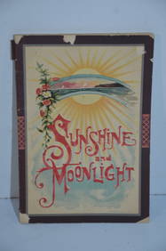
Chicago Rock Island and Pacific RR Book Sunshine and Moonlight-1889JM Hobby Supply and Railroad Artifact Auctions4.4(126)See Sold PriceFeb 24, 2024
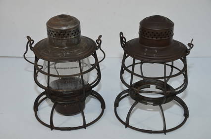
Two Different Early Armspear Lanterns-Lehigh Valley RR/Long Island RRJM Hobby Supply and Railroad Artifact Auctions4.4(126)See Sold PriceFeb 24, 2024
Robert William Wood (1889 - 1979) Texas BluebonnetsPremier Auction Galleries4.3(329)See Sold PriceMar 09, 2024
Lalique Crystal Shark Figurine with Original Box. Atlantis The Shark Made in FranceSJ Auctioneers4.5(165)See Sold PriceMar 03, 2024
[SHIPPING DOCUMENTS]. A Pair of Shipping Documents for Vess...Potter & Potter Auctions4.6(539)See Sold PriceMar 07, 2024
Framed Oil On Canvas Signed JUAN GIL GARCIA (1879-1932 CUBA)Basel Auction House4.4(43)See Sold PriceFeb 24, 2024
Unframed Print Dated 94 and signed Tomas Sanchez (Cuba, B. 1948) lower right.Basel Auction House4.4(43)See Sold PriceFeb 24, 2024
Catesby, Folio - Tumble-Turds (Dung Beetle) with Canada Lily. Sup-11Trillium Antique Prints & Rare Books4.5(30)See Sold PriceFeb 24, 2024
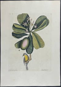
Catesby, Folio - American Goldfinch with Acacia. 1-43Trillium Antique Prints & Rare Books4.5(30)See Sold PriceFeb 24, 2024
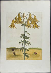
Catesby, Folio - Bahama Titmouse with Seven Years Apple. 1-59Trillium Antique Prints & Rare Books4.5(30)See Sold PriceFeb 24, 2024
Catesby, Folio - American Partridge with Attamusco Lily. Sup-12Trillium Antique Prints & Rare Books4.5(30)See Sold PriceFeb 24, 2024
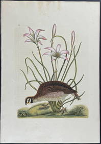
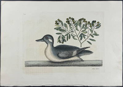
Catesby, Folio - Little Brown Duck with Soap-Wood. 1-98Trillium Antique Prints & Rare Books4.5(30)See Sold PriceFeb 24, 2024
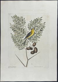
Catesby, Folio - Red Bellied Woodpecker & Hairy Woodpecker with Black Oak. 1-19Trillium Antique Prints & Rare Books4.5(30)See Sold PriceFeb 24, 2024
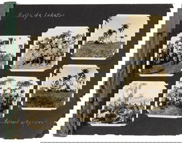
Mid Century & Vintage Postcards Germany, Paris +The Benefit Shop Foundation Inc.4.3(2.9k)See Sold PriceMar 13, 2024
1683 Sanson Map of the Caribbean -- Les Isles Antilles, &c Entre Lesquelles sont les Lucayes, et lesJasper524.5(9.8k)See Sold PriceFeb 27, 2024


![[SHIPPING DOCUMENTS]. A Pair of Shipping Documents for Vess... (1 of 4)](https://p1.liveauctioneers.com/928/318880/171361193_1_x.jpg?height=282&quality=70&version=1707501302)