ATLAS of ANTIENT GEOGRAPHY by SAMUEL BUTLER 1843John McInnis Auctioneers,LLC4.6(502)See Sold PriceFeb 24, 2024
18TH C. ANTIQUE MAP: FRENCH & INDIAN WAR, FRAMEDThomaston Place Auction Galleries4.4(386)See Sold PriceFeb 24, 2024
Rand McNally Railroad Map Cabinet w/ 21 Railroad MapsRail & Road Auctions4.6(165)See Sold PriceMar 08, 2024
Keith Haring - Ink on New York Map, Best Buddies, Inscribed, Signed, and DatedSapphire Auction Gallery4(67)See Sold PriceMar 02, 2024
LATE 17TH C. FRENCH MAP OF THE NEW WORLD BY ALEXIS-HUBERT JAILLOT (1632-1712)Thomaston Place Auction Galleries4.4(386)See Sold PriceFeb 24, 2024
Central Railroad of New Jersey Map of Sandy Hook Route-ca. 1903JM Hobby Supply and Railroad Artifact Auctions4.4(126)See Sold PriceFeb 24, 2024
Lot of Six Mixed Atlas Box Cars-HO Scale-New in BoxJM Hobby Supply and Railroad Artifact Auctions4.4(126)See Sold PriceFeb 25, 2024
Rand McNally/Santa Fe Railroad Map of Iowa-1912JM Hobby Supply and Railroad Artifact Auctions4.4(126)See Sold PriceFeb 24, 2024
NICOLAES VISSCHER (NETHERLANDS, 1618-1709) MAP OF THE NEW WORLDThomaston Place Auction Galleries4.4(386)See Sold PriceFeb 24, 2024
17TH C. WORLD MAP BY NICOLAES VISSCHER (NETHERLANDS, 1618-1709)Thomaston Place Auction Galleries4.4(386)See Sold PriceFeb 24, 2024
Lot of Six Mixed Atlas Cabooses-HO Scale-New in BoxJM Hobby Supply and Railroad Artifact Auctions4.4(126)See Sold PriceFeb 25, 2024
SoldCornwall.- Morden (Robert) Cornwall, [c. 1695]; and twoNO RESERVE Cornwall.- Morden (Robert) Cornwall, engraving with some hand-colouring, sheet 380 x 425 mm. (15 x 16 3/4 in), framed and glazed, [c. 1695]; together with Saxton/Hole map of Herefordshire,See Sold Price
SoldMorden (Robert) Cornwall; Somersetshire; DorsetshiMorden (Robert) Cornwall; Somersetshire; Dorsetshire; Devonshire,engraved maps with oultine hand-colouring, each c.365 x 420mm, central vertical folds, minor surface dirt, Abel Swale, AwnshamSee Sold Price
Sold-. Morden (Robert) - A group of 7 English county maps,Cornwall, Essex, Hertfordshire, Oxfordshire, Warwickshire, Wiltshire and Worcestershire, engraved maps with hand-colouring, each c.370 x 440mm., or the reverse, one or two partially trimmed into the sSee Sold Price
Robert MordenRobert Morden. Cornwall. [1695]. Incisione in rame con coloritura coeva. Mm 360x430 con margini a filo dell'incisione di 2 lati su 4. Titolo entro cartiglio in alto a sinistra. Buona carta della CornSee Sold Price
SoldKent.- Morden (Robert) Kent, [c. 1695].Kent.- Morden (Robert) Kent, county map, engraving with some outline hand-colouring on laid paper, platemark 360 x 640 mm. (14 1/4 x 25 1/8 in), sheet 415 x 655 mm. (16 1/4 x 25 3/4 in), folds as issuSee Sold Price
Sold209: [Great Britain]. Morden, Robert. Hampshire [c1695[Great Britain]. Morden, Robert. Hampshire [c1695]. Copperplate engraved map in contemporary hand color. 14.5 x 16.5 inches. 2-inch tear in blank Wiltshire, else very good. Verso blank.See Sold Price
SoldAntique Map Devonshire Robert Morden c1695Antique map from Camden's Britannia engraved by Robert Morden (English, c1650-1703). Map measures 14 1/8” tall, 16 3/8” wide (35.9 x 41.6 cm) to outer neat line. Framed under glass.See Sold Price
Maps of England by Robert Morden c.1695Title: Collection of 7 maps of England and her parts by Robert Morden Author: Morden, Robert Description: Includes: England. (Verso repair along centerfold, a few other repairs.) * England. (Split halSee Sold Price
SoldAN ANTIQUE MAP OF NORTHUMBERLAND by Robert Morden C1695. 41 cm x 36 cm.AN ANTIQUE MAP OF NORTHUMBERLAND by Robert Morden C1695. 41 cm x 36 cm.See Sold Price
A handtinted coloured map of Scotland by Robert MordenA handtinted coloured map of Scotland by Robert Morden c1695, 43 x 35cm.See Sold Price
Robert Morden Map “Kentâ€, c.1695Renowned map maker Robert Morden (England, 1650-1703), possibly first edition, features three different scales of miles also Thanet, Sheppey, Sandwich, Folkstone, Dover, Hythe, Rochester, Blackheath,See Sold Price
Sold18th century map of Cornwall by Robert Morden 16 x18th century map of Cornwall by Robert Morden 16 x 18in. (41 x 46cm)See Sold Price
Saxton Map of DorcesterDorcestriae Comitatis Vulgo Dorsett... After Christopher Saxton (1542-1610), Robert Morden. Engraved map. London, c. 1695-1722. 11 1/2 x 15 1/2 inches visible, 20 x 24 inches framed. A fine example ofSee Sold Price
SoldRobert Morden (c. 1650 - 1703), by, two-fold map,Robert Morden (c. 1650 - 1703), by, two-fold map, Britannia Romana (sic), [London 1722], engraving, contemporaneous hand-colouring, 36cm x 43cmSee Sold Price
Robert Morden (c. 1650 - 1703), by, two-page map,Robert Morden (c. 1650 - 1703), by, two-page map, Darbyshire (sic, Derbyshire), [Published and] Sold by Abel Swale, Awnfham (sic) and John Churchill, London[c. 1722], hand-coloured copperplate engraviSee Sold Price
SoldRobert Morden Map, "Britannia Romana",Robert Morden Map, "Britannia Romana",English, c. 1695, hand-colored copperplate engraving, decorative title cartouche in upper left corner, scale in miles, a highly detailed and attractive map of BriSee Sold Price
Sold-. Morden (Robert) Hampshire-. Morden (Robert) Hampshire,engraved map with hand colouring, 365 x 420mm, [c.1695] § Ogilby (John) The Road From London to Lands End, being London to Winchester, engraved road map with handSee Sold Price
SoldMorden (Robert) The Kingdom of IrelandMorden (Robert) The Kingdom of Ireland,title cartouche, upper left, engraved map with hand-colouring, 420 x 350mm, central horizontal fold, sold by Awnsham and Churchill, c.1695 or later.See Sold Price
SoldMorden (Robert) WiltshireMorden (Robert) Wiltshire,engraved map with outline hand-colouring, 350 x 420mm., central vertical fold, c.1695; with a county map of Wiltshire from Camden's Britannia, and another by RichardSee Sold Price
Morden (Robert) - Cambridge Shire,engraved map by Sutton Nicholls, 430 x 365mm., central horizontal fold, Abel Swale, Awnsham and John Churchill, c.1695; with a map of Berkshire, with surrounding views, by Herman Moll; and a facsimileSee Sold Price
Sold-. Morden (Robert) - Bark Shire,engraved map, with hand-colouring, 380 x 430 mm., central vertical fold, handling creases, spotting and browning, [c.1695 ].See Sold Price
Berkshire.- Morden (Robert) Bark ShireBerkshire.- Morden (Robert) Bark Shire,engraved map, with hand-colouring, 380 x 430 mm., central vertical fold, handling creases, spotting and browning, [c.1695].See Sold Price
Sold-. Morden (Robert) Bark Shire-. Morden (Robert) Bark Shire engraved map with hand-colouring, 365 x 430mm., central vertical fold, laid on thin conservation board support, Abel Swale, Awnsham & John Churchill, [c.1695].See Sold Price
SoldMorden (Robert) WiltshireMorden (Robert) Wiltshire,engraved map with outline hand-colouring, 350 x 420mm., central vertical fold, c.1695; with a county map of Wiltshire from Camden's Britannia, and another by RichardSee Sold Price
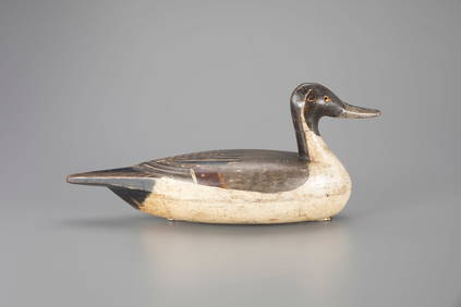
Pintail Drake Decoy by Robert Bradbeer (1886-1955)Copley Fine Art Auctions4.5(40)See Sold PriceFeb 24, 2024
18TH C. ENGLISH PEWTER PLATES & PLATTERS BY ROBERT NICHOLSONThomaston Place Auction Galleries4.4(386)See Sold PriceFeb 24, 2024
17TH C. ENGLISH LINEAR MAP BY OGILBY, FRAMEDThomaston Place Auction Galleries4.4(386)See Sold PriceFeb 24, 2024
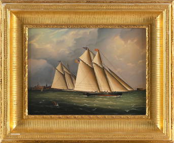
WILLIAM ROBERT DAVIS (Massachusetts, 1952-), Two New York Yacht Club yachts racing off CastleEldred's4.7(409)See Sold PriceFeb 28, 2024
Portfolio of 15 County Maps by Robert Morden (English 1650-1703)Nadeau's Auction Gallery4.7(401)See Sold PriceFeb 24, 2024
Pastel Drawing of two women by Bynz Robert c 1930Global Auctions Company4.3(36)See Sold PriceMar 03, 2024
Two Innisbrook Golf Club Signed Watercolors by Robert R. Young (American, 20th C.) Island Course No.Hoch LTD.4.5(73)See Sold PriceFeb 25, 2024
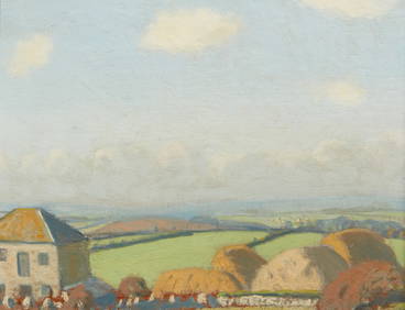
Robert Morson Hughes, Farm Buildings in CornwallAndrew Jones Auctions4.7(206)See Sold PriceFeb 28, 2024
Set of Two (2) "Flight" Sling Stacking Lounge Chairs w/ One Ottoman by Brown Jordan USA c. 2011Bidhaus4.3(747)See Sold PriceMar 04, 2024
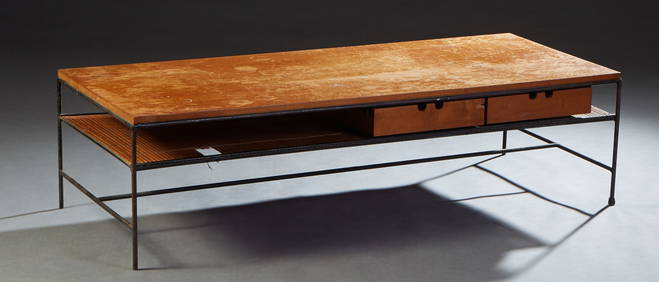
Paul McCobb Planner Group Iron and Birch Coffee Table, mid 20th c., H.- 16 in., W.- 60 in., D.- 24Crescent City Auction Gallery4.3(229)See Sold PriceMar 09, 2024
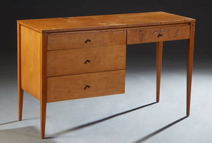
Paul McCobb Planner Group Mid-Century Modern Maple Desk, mid 20th c., H.- 29 1/2 in., W.- 48 in.,Crescent City Auction Gallery4.3(229)See Sold PriceMar 09, 2024
TWO 18TH C. PORTSMOUTH NH CHIPPENDALE SIDE CHAIRS.William Smith Auctions4.6(146)See Sold PriceMar 06, 2024
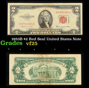
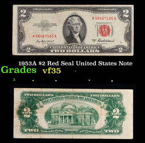
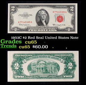
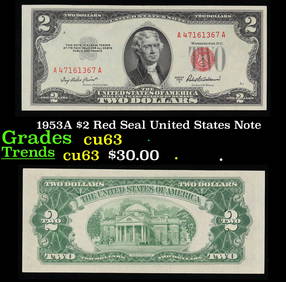
1953A $2 Red Seal United States Note Grades Select CUKey Date Coins4.2(1.2k)See Sold PriceFeb 28, 2024
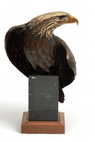
Dr. Robert Taylor (American, 20th C.) Bronze Sculpture, Ca. 1991, "Vigilance", H 15.25" W 9" DepthDuMouchelles4.6(825)See Sold PriceMar 15, 2024


![Cornwall.- Morden (Robert) Cornwall, [c. 1695]; and two First Image](https://p1.liveauctioneers.com/5458/147572/74579063_1_x.jpg?height=282&quality=95&version=1565275641&width=282)

![Cornwall.- Morden (Robert) Cornwall, [c. 1695]; and two First Image](https://p1.liveauctioneers.com/5458/147572/74579063_1_x.jpg?height=282&quality=1&version=1565275641&width=282)


![Cornwall.- Morden (Robert) Cornwall, [c. 1695]; and two (1 of 1)](https://p1.liveauctioneers.com/5458/147572/74579063_1_x.jpg?height=282&quality=70&version=1565275641)


![Kent.- Morden (Robert) Kent, [c. 1695]. (1 of 1)](https://p1.liveauctioneers.com/5458/156131/78785369_1_x.jpg?height=282&quality=70&version=1574849334)
![209: [Great Britain]. Morden, Robert. Hampshire [c1695 (1 of 0)](https://p1.liveauctioneers.com/dist/images/placeholder.jpg?height=282&quality=70)