Copy of Virginia Map of 1609, Framed FraCopy of Virginia Map of 1609, Framed Framed Map of Virginia from the Descriptions of Captain John Smith. Shows the Chesapeake Bay & Areas of Various Indian Tribes with Veiled Reference to Smith's RescSee Sold Price
SoldFramed copy of an Augustine Herrman 1673 map of VirginiFramed copy of an Augustine Herrman 1673 map of Virginia and Maryland. In 4 sections, with discoloration and water stains.See Sold Price
SoldVirginiae Item et Floridae Americae Provinciarum NovaJodocus Hondius (1563-1612). Amsterdam, c. 1609. 18 x 22 inches, 27 1/2 x 31 1/2 inches framed. Hondius utilized John White’s map of Virginia and Jacques Le Moyne’s map of Florida to create what aSee Sold Price
SoldLe Pais de Caux Map After Henricus Hondius.Le Pais de Caux map. 19th century copy after the 1638 original by Henricus Hondius. Lined paper. Framed under glass. Sight: 15 1/2 x 20"; frame: 22 1/2" x 27".See Sold Price
Sold[Map] 1862 Eastern Virginia Militaire20 in. L., 22 in. H. with Rand McNally & Co. Virginia Map, framed 29 in. L., 24 in. H.See Sold Price
Sold4 Maps incl. Division of US Army in Virginia4 Maps Atlas to Accompany the Official Records of Union + Confederate Army's 1861-1865, US Army in Virginia Map Framed with Tear -See Sold Price
SoldAntique Framed Map. Virginia Marylandia et Carolina. JoAntique Framed Map. Virginia Marylandia et Carolina. Johannes Baptisa Homann-- Dimensions: Image Size: H: 21 inches: W: 24.5 inches -- FRAME SIZE: Frame Height 25 inches - Frame Width 28.5 inches ---See Sold Price
SoldHand-Colored Map titled, “NOVA VIRGINIAE TABULA”Historic Maps Circa 1629 Willem Blaeu’s “NOVA VIRGINIAE TABULA” Beautiful Hand-Colored Early Virginia Framed Map c. 1629, Hand-Colored Map titled, “NOVA VIRGINIAE TABULA” by “BLAEU, W.”See Sold Price
SoldFramed Map of Virginia Maryland Delaware & DCLarge Decorative Framed Map of Virginia Maryland Delaware and District of Columbia, new condition, 38" x 68"See Sold Price
SoldMap Of VirginiaA framed map of Virginia, 17" X 19". “Terre-Marie Nova et Virginiae Tabula” shows the “Chesapeack” and many Native American tribe locations. Shipping: We are able to pack and ship this item toSee Sold Price
SoldFramed Early World Map with hand tintingMid 19th c. copy of an earlier map. Framed size: 19.5" x 17.5" Buyers is responsible for pickup or shipping. We have a local UPS store that will ship nearly anythingSee Sold Price
Copy of Antique St. Thomas MapSt. Thomas Dansk Americansk O'. Lithographic copy of 1846 map. Well framed. Overall 28.25 x 18.5".See Sold Price
Sold2 Maps incl: Il Maryland, Il Jersey Meridionale...[Virginia]. 2 Maps. Matted and framed under glass. Not examined out of frame. ++ Antonio Zatta. Il Maryland, Il Jersey Meridionale, La Delaware, e la Parte Orientale della Virginia, e Carolina SettentSee Sold Price
SoldEaly map of Virginia 1609Heading: (Virginia & Carolina) Author: Hondius, Jodocus Title: Virginiae Item et Floridae Americae Provinciarum, Nova Descriptio Place Published: Amsterdam Publisher: Date Published: 1606-[16See Sold Price
SoldEaly map of Virginia 1609Heading: Author: Hondius, Jodocus Title: Virginiae Item et Floridae Americae Provinciarum, Nova Descriptio Place Published: Amsterdam Publisher: Date Published: 1606-[1609] DescriptionSee Sold Price
SoldA lot of 6 Maps of Israel and Jerusalemsix framed maps engravings and copies of Israel and Jerusalem. Made according to maps from the 17th and 18th century. All of the maps are in good condition and in quality framing.See Sold Price
SoldCopy of Map of Virginia by Herman BoyeThe original dating to 1827 / 28 was engraved by H. S. Tanner and E. B. Dawson. Considered to be one of the first official state maps of Virginia. Multiple condition issues, including (but not limitedSee Sold Price
SoldFramed Civil War Map; SUFFOLK VIRGINIA AND VICINITY:Framed Civil War Map; SUFFOLK VIRGINIA AND VICINITY: From "THE WAR OF REBELLION, OFFICIAL RECORDS UNION AND CONFEDERATE ARMIES". Detailed Look at the Civil War's Here in Our Own Norfolk, Portsmouth &See Sold Price
Map of Virginia, 1840 (Framed)Original engraving from A New Universal Atlas by Greenleaf, Vermont, 1840. Custom Framed in UV protectant glass. Dimensions: 19" x 20 1/2" Shipping Domestic: Shipping rates are determind by destinatioSee Sold Price
Map of Virginia, 1840 (Framed)Map of Virginia, 1840 (Framed). Original engraving from A New Universal Atlas by Greenleaf, Vermont, 1840. Custom Framed in UV protectant glass. Dimensions: 19" x 20 1/2"See Sold Price
(MAP) A modern facsimile copy of a sixteenth cent(MAP) A modern facsimile copy of a seventeenth century world map. Framed. In color. Size of frame 31 x 37 inches Property from the Collection of a New York-Based Financial InstitutionSee Sold Price
SoldGroup of seven Augustus Mitchell framed maps to includeGroup of seven Augustus Mitchell framed maps to include Tennessee, Virginia, Colorado, Ohio, Michigan, Georgia, and Kansas. sight sizes 12" x 15" - 20" x 14". Provenance: Property from the Credit SuisSee Sold Price
Terrance Guardipee Original Ledger Painting FramedSan Diego Art Auction4.3(9)See Sold PriceFeb 24, 2024
RARE 1638 HONDIUS MAP OF BERMUDA, FRAMEDThomaston Place Auction Galleries4.4(389)See Sold PriceFeb 24, 2024
EARLY 18TH C. MAP OF ITALY, FRAMEDThomaston Place Auction Galleries4.4(389)See Sold PriceFeb 24, 2024
LATE 16TH C. MAP OF SCOTLAND BY MERCATOR, FRAMEDThomaston Place Auction Galleries4.4(389)See Sold PriceFeb 24, 2024
18TH C. ANTIQUE MAP: FRENCH & INDIAN WAR, FRAMEDThomaston Place Auction Galleries4.4(389)See Sold PriceFeb 24, 2024
17TH C. ENGLISH LINEAR MAP BY OGILBY, FRAMEDThomaston Place Auction Galleries4.4(389)See Sold PriceFeb 24, 2024
1937 Holland, Michigan, Tulip Time Map Guide, FramedLakeshore Event Center4.6(105)See Sold PriceMar 02, 2024
Kilburg Geochron Lighted Scrolling Framed MapNadeau's Auction Gallery4.7(405)See Sold PriceFeb 24, 2024
1855 Map of New York & Erie Railroad and 1917 Trespassing On Railway Property Is A MisdemeanorRail & Road Auctions4.6(165)See Sold PriceMar 07, 2024
Pair of Early Railroad Maps - 1874 Delaware, Lackawanna & Western and 1876 Pennsylvania RailroadRail & Road Auctions4.6(165)See Sold PriceMar 07, 2024
1867 Map of the Railroads of The State of New YorkRail & Road Auctions4.6(165)See Sold PriceMar 08, 2024
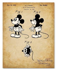
WALT DISNEY Mickey Mouse U.S. Patent Office Art PrintSouth Florida Auction & Estate Sale Services Inc4.5(522)See Sold PriceMar 08, 2024
Two (2) Antique 18th C. Copper Engraved Framed Maps - America & EuropeMagnusson Art Group4.5(50)See Sold PriceMar 14, 2024
THREE JAPANESE WOODBLOCK PRINTS BY KITIGAWA UTAMARO (1753-1806) TITLED PARODY OF AN IMPERIALThe Rug Life4.3(12)See Sold PriceMar 07, 2024
Framed Space Age Rand McNally Map of Planets Poster, 1958PUBLIC SALE4.7(225)See Sold PriceMar 02, 2024
Vintage 1920s Rand McNally Auto Trails MapThe Benefit Shop Foundation Inc.4.3(2.9k)See Sold PriceMar 20, 2024


![[Map] 1862 Eastern Virginia Militaire (1 of 8)](https://p1.liveauctioneers.com/523/84219/43476527_1_x.jpg?height=282&quality=70&version=1453240168)