ATLAS of ANTIENT GEOGRAPHY by SAMUEL BUTLER 1843John McInnis Auctioneers,LLC4.5(505)See Sold PriceFeb 24, 2024
18TH C. ANTIQUE MAP: FRENCH & INDIAN WAR, FRAMEDThomaston Place Auction Galleries4.4(393)See Sold PriceFeb 24, 2024
Rand McNally Railroad Map Cabinet w/ 21 Railroad MapsRail & Road Auctions4.6(165)See Sold PriceMar 08, 2024
Keith Haring - Ink on New York Map, Best Buddies, Inscribed, Signed, and DatedSapphire Auction Gallery4.1(67)See Sold PriceMar 02, 2024
LATE 17TH C. FRENCH MAP OF THE NEW WORLD BY ALEXIS-HUBERT JAILLOT (1632-1712)Thomaston Place Auction Galleries4.4(393)See Sold PriceFeb 24, 2024
Central Railroad of New Jersey Map of Sandy Hook Route-ca. 1903JM Hobby Supply and Railroad Artifact Auctions4.4(127)See Sold PriceFeb 24, 2024
Lot of Six Mixed Atlas Box Cars-HO Scale-New in BoxJM Hobby Supply and Railroad Artifact Auctions4.4(127)See Sold PriceFeb 25, 2024
Rand McNally/Santa Fe Railroad Map of Iowa-1912JM Hobby Supply and Railroad Artifact Auctions4.4(127)See Sold PriceFeb 24, 2024
NICOLAES VISSCHER (NETHERLANDS, 1618-1709) MAP OF THE NEW WORLDThomaston Place Auction Galleries4.4(393)See Sold PriceFeb 24, 2024
17TH C. WORLD MAP BY NICOLAES VISSCHER (NETHERLANDS, 1618-1709)Thomaston Place Auction Galleries4.4(393)See Sold PriceFeb 24, 2024
Lot of Six Mixed Atlas Cabooses-HO Scale-New in BoxJM Hobby Supply and Railroad Artifact Auctions4.4(127)See Sold PriceFeb 25, 2024
Huge Battletech CollectionHuge Battletech Collection! Bins and bins full of figures, tanks, etc. including spare parts, paint and repair items, Battletech card collection, maps, new and unoopened figures and accessories, pewteSee Sold Price
SoldArmillary Sphere by Andreas Cellarius, 1600 ArmillaryArmillary Sphere by Andreas Cellarius, 1600, reproduction from the original in the Rand McNally & Company collection, map of the globe with different Latin writing, professionally framed and matted, cSee Sold Price
SoldAntique Maps: Collection of Five Map Depicting VariousAll unframed. Largest: 14" wd x 8.5" ht.See Sold Price
SoldEarly Los Angeles Map Collection [135820]Lot of 11, most different. Included: City & Harbor of Los Angeles, 1921; Special Sightseeing Map of Los Angeles & Vicinity, 1930; Official Transportation and City Map of Los Angeles, Cal and Suburbs,See Sold Price
SoldA Collection of Maps.A Collection of Maps. Including 'A Series of Maps for a General Atlas', a string-bound album containing maps of Michigan, Maine, Ohio, the Netherlands, and 25 Miles Round the City of New York, engraviSee Sold Price
SoldA Collection of MapsA Collection of Maps 19th and 20th century topographical maps with twenty-seven unframed and one framed example. 17 3/4 X 22 1/2 inches (framed). Estimate $100-200See Sold Price
SoldAmerican Progression Map CollectionItems as shown. Collection of 10 Maps Framed 32x21.5 Framed VintageSee Sold Price
Sold1800's RARE Map CollectionThis is large collection of RARE hand colored maps from both atlases and individuals. This collection includes: 1886 hand colored Colorado and others includes New Mexico, Texas, California, Nevada, WaSee Sold Price
SoldSchoolhouse Map Collection circa 1870This is a collection of over 20 hand drawn maps of the United States from a schoolhouse circa 1870. Although not labeled, it is believed some of the maps detail events of the Revolutionary War as wellSee Sold Price
SoldCOLLECTION OF MAPSPORTUGAL, OKLAHOMA INDIAN TERRITORY, AMSTERDAM, BERLIN, CUBA. SMALLEST IS 9 1/2" BY 11 1/2". LARGEST IS 13" BY 18 1/2"See Sold Price
SoldCOLLECTION OF MAPSWORLD MAP, ASIA, NEW YORK CENTRAL, COLORADO, ALSO BROCHURES INCLUDING SHELL GAS STATION AND OTHERS.See Sold Price
Sold1897 Western and Central U.S. Map CollectionThis lot features a collection of Western and Central U.S. maps from 1897. Included is Washington, Oregon, a combined map of Nevada and Utah, and a combined map of Oklahoma and Indian Territory. The mSee Sold Price
Sold1855 Smith’s ATLAS Geography 36 BEAUTIFUL Colored MAPS1855 Smith’s ATLAS Geography 36 BEAUTIFUL Colored MAPS World ‘Smith’s Atlas of Modern and Ancient Geography’ is a collection of maps focusing on the United States, but includes maps of the worSee Sold Price
SoldAntique Map: Imperii Turcarum Arabum et PersarumCOVENS and MORTIER. Imperii Tucarum Arabum et Perarum. Double-page engraved map, 505x580 mm, wide margins; hand-colored in outline. Amsterdam, circa 1720.See Sold Price
SoldAntique Map: Estats de l'Empire du Grand Seigneur desSanson's map of the Ottoman Empire, extending from Italy to the Straits of Hormuz. Minor hand-coloring. 21" wd x 16" ht.See Sold Price
SoldCarey's General Atlas, Improved And Enlarged; Being ACarey's General Atlas, Improved And Enlarged; Being A Collection Of Maps Of The World And Quarters, Their Principal Empires, Kingdoms, &c. ... Philadelphia: Published By M. Carey. 1814. T.S. Manning,See Sold Price
SoldAMERICAN HISTORICAL ATLAS VOLUMEAMERICAN HISTORICAL ATLAS VOLUME, the so-called "Carey's General Atlas", or "A General Atlas; Being a Collection of Maps of the World and Quarters, Their Principal Empires, Kingdoms, &c.", 1816, M. CaSee Sold Price
Sold1652 Map of Arabia: L'Arabie, Petree, Deserte, etDetailed map on laid paper centered on the Arabian Peninsula. Engraving with hand coloring. 10" ht. x 13" wd. central vertical fold with small tear. Not framed.See Sold Price
SoldCarey's General Atlas Improved & Enlarged 1816 ed.Being a collection of Maps of the world and quarters their principal empires, kingdoms, etc. Philadelphia; Published by M. Carey no. 121 Chestnut Street 1816. pages foxed, toned, and imprinted left toSee Sold Price
SoldJOAN BLAEU ATLAS MAIOR 1792 PRINTINGSold as a collection of maps, hand colored engravings. Text in Dutch. Contains 40 maps/plates. With original hand coloring. Dimensions: (Maps open) H 21.5" x W 25.25" Condition: As is. Varying damagesSee Sold Price
LARGE GULF SERVICE STATION MAP COLLECTION WITH DISPLAY STAND.Dan Morphy Auctions4.2(1.3k)See Sold PriceFeb 24, 2024
1885 CIVIL WAR 1ed Famous Memoirs US Grant Sheridan Sherman 6v RARE LOT MapsSchilb Antiquarian Rare Books4.8(428)See Sold PriceMar 10, 2024
Collection of 10 Maps of Cities in Israel for TouristsLevy Auction House4.3(11)See Sold PriceFeb 27, 2024
Caravan Routes in Palestine Linen Map - Germany, 1881Levy Auction House4.3(11)See Sold PriceFeb 27, 2024
18 Booklets Collection - War Graves of Palestine - WWILevy Auction House4.3(11)See Sold PriceFeb 27, 2024
Collection of Allied Military Silk Printed Maps, WWII Era and LaterMaterial Culture4.6(778)See Sold PriceFeb 29, 2024
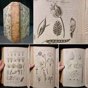
1797 Universal Magazine BOTANY PLATES Flowers FRUIT 12 Copper Engraved PlatesPrivate NY Collection4.2(22)See Sold PriceMar 01, 2024
1816 MAP SOUTHERN PART OF RUSSIA or MUSCOVY in EUROPE copper engraving ANTIQUEJasper524.5(9.9k)See Sold PriceFeb 27, 2024
1816 MAP NORTHERN PART OF RUSSIA or MUSCOVY in EUROPE copper engraving ANTIQUEJasper524.5(9.9k)See Sold PriceFeb 27, 2024
Nottingham.- Ordnance Survey Office (publisher) Collection 8 geological maps on the environs ofForum Auctions4.3(53)See Sold PriceFeb 29, 2024
Jules Verne, Le Testament d'un Excentrique, Aux HarponsLion and Unicorn4.8(1.9k)See Sold PriceMar 03, 2024
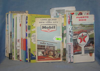
Collection of vintage auto related travel mapsBaker's Antiques and Auctions3.2(471)See Sold PriceFeb 25, 2024
Framed Collection Engravings & A Map From The Excursions In The County Of Sussex Published In 1822Rapid Estate Liquidators and Auction Gallery4.5(1.1k)See Sold PriceMar 01, 2024
Jules Verne, L'Etoile du Sud, Au Steamer Red MacaronLion and Unicorn4.8(1.9k)See Sold PriceMar 10, 2024


![Early Los Angeles Map Collection [135820] (1 of 1)](https://p1.liveauctioneers.com/2699/211814/108066471_1_x.jpg?height=282&quality=70&version=1626720358)