ATLAS of ANTIENT GEOGRAPHY by SAMUEL BUTLER 1843John McInnis Auctioneers,LLC4.5(505)See Sold PriceFeb 24, 2024
18TH C. ANTIQUE MAP: FRENCH & INDIAN WAR, FRAMEDThomaston Place Auction Galleries4.4(394)See Sold PriceFeb 24, 2024
Rand McNally Railroad Map Cabinet w/ 21 Railroad MapsRail & Road Auctions4.6(165)See Sold PriceMar 08, 2024
Keith Haring - Ink on New York Map, Best Buddies, Inscribed, Signed, and DatedSapphire Auction Gallery4.1(67)See Sold PriceMar 02, 2024
LATE 17TH C. FRENCH MAP OF THE NEW WORLD BY ALEXIS-HUBERT JAILLOT (1632-1712)Thomaston Place Auction Galleries4.4(394)See Sold PriceFeb 24, 2024
Central Railroad of New Jersey Map of Sandy Hook Route-ca. 1903JM Hobby Supply and Railroad Artifact Auctions4.4(127)See Sold PriceFeb 24, 2024
Lot of Six Mixed Atlas Box Cars-HO Scale-New in BoxJM Hobby Supply and Railroad Artifact Auctions4.4(127)See Sold PriceFeb 25, 2024
Rand McNally/Santa Fe Railroad Map of Iowa-1912JM Hobby Supply and Railroad Artifact Auctions4.4(127)See Sold PriceFeb 24, 2024
NICOLAES VISSCHER (NETHERLANDS, 1618-1709) MAP OF THE NEW WORLDThomaston Place Auction Galleries4.4(394)See Sold PriceFeb 24, 2024
17TH C. WORLD MAP BY NICOLAES VISSCHER (NETHERLANDS, 1618-1709)Thomaston Place Auction Galleries4.4(394)See Sold PriceFeb 24, 2024
Lot of Six Mixed Atlas Cabooses-HO Scale-New in BoxJM Hobby Supply and Railroad Artifact Auctions4.4(127)See Sold PriceFeb 25, 2024
SoldCirca 1742 Map of Canaan by Rev Thomas StackhouseCirca 1742 Map of Canaan by Reverend Thomas StackhouseSee Sold Price
MAP, Russia in Europe, StackhouseRussia in Europe. Thomas Stackhouse, Russia in Europe, 1804 (circa). Hand Color. This map of Russia was issued as plate #15 in Stackhouse's An Universal Atlas, Consisting of A Complete Set of Maps, PeSee Sold Price
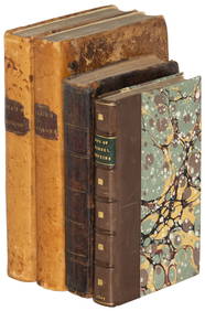
SoldStackhouse's History of the Bible, 1742Stackhouse, Thomas. A NEW HISTORY OF THE HOLY BIBLE, FROM THE BEGINNING OF THE WORLD, TO THE ESTABLISHMENT OF CHRISTIANITY. London: Stephen Austen, 1742-1744. Folio (15" x 9.25".) 2 volumes, paginatioSee Sold Price
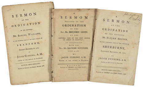
1743 Vertue Engraving of Rev Thomas Stackhouse1743 engraving by George Vertue of the Reverend Thomas Stackhouse, measures 9 x 15". Fine with short tear at left margin. Please note that this lot has a confidential reserve. When you leave a bid inSee Sold Price
1743 Vertue Engraving of Rev Thomas Stackhouse1743 engraving by George Vertue of the Reverend Thomas Stackhouse, measures 9 x 15". Fine with short tear at left margin. Please note that this lot has a confidential reserve. When you leave a bid inSee Sold Price
1743 Vertue Engraving of Rev Thomas Stackhouse1743 engraving by George Vertue of the Reverend Thomas Stackhouse, measures 9 x 15". Fine with short tear at left margin. Reserve: $30.00 Shipping: Domestic: Flat-rate of $10.00 to anywhere within theSee Sold Price
1743 Vertue Engraving of Rev Thomas Stackhouse1743 engraving by George Vertue of the Reverend Thomas Stackhouse, measures 9 x 15”. Fine with short tear at left margin. Reserve: $20.00 Shipping: Domestic: Flat-rate of $5.00 to anywhere within thSee Sold Price
1743 Vertue Engraving of Rev Thomas Stackhouse1743 engraving by George Vertue of the Reverend Thomas Stackhouse, measures 9 x 15”. Fine with short tear at left margin. Reserve: $30.00 Shipping: Domestic: Flat-rate of $10.00 to anywhere within tSee Sold Price
1743 Vertue Engraving of Rev Thomas Stackhouse1743 engraving by George Vertue of the Reverend Thomas Stackhouse, measures 9 x 15". Fine with short tear at left margin. Please note that this lot has a confidential reserve. When you leave a bid inSee Sold Price
1743 Vertue Engraving of Rev Thomas Stackhouse1743 engraving by George Vertue of the Reverend Thomas Stackhouse, measures 9 x 15". Fine with short tear at left margin. Reserve: $30.00 Shipping: Domestic: Flat-rate of $10.00 to anywhere within theSee Sold Price
SoldHistory of the Holy Bible Vol. 1-6, Stackhouse 17By Rev. Thomas Stackhouse, 1795-1796. Fair condition - loose binding - leatherboundSee Sold Price
SoldThomas Kitchin's New Map of Ireland Ca. 1795Laurie & Whittle Publishers circa 1795 map. Thomas Kitchins Hydrographer to his majesty. A New Map of Ireland Divided into Provinces & Counties. Frame: 27.5" x 24 3/8" image sight: 26.25" x 23 1/8". HSee Sold Price
Thomas Kitchin's New Map of Ireland Ca. 1795Laurie & Whittle Publishers circa 1795 map. Thomas Kitchins Hydrographer to his majesty. A New Map of Ireland Divided into Provinces & Counties. Frame: 27.5" x 24 3/8" image sight: 26.25" x 23 1/8". HSee Sold Price
Sold(BIBLE) STACKHOUSE, REV. THOMAS. A New History of(BIBLE) STACKHOUSE, REV. THOMAS A New History of the Holy Bible, from the Beginning of the World, to the Establishment of Christianity. . . London: Printed for John Hinton, 1755, 1764. 2 vols. Folio,See Sold Price
SoldPAIR OF CIRCA 1810 MAPS BY THOMAS BROWNNorth America and The United States of America. Both published by Tho.s (Thomas) Brown, Edinburgh, and were part of Brown's General Atlas. Both are hand colored. Measures 14.5 x 12.75 inches. We happiSee Sold Price
Sold12 VINTAGE MAPS OF VARIOUS COUNTRIES12 VINTAGE MAPS OF VARIOUS COUNTRIES. Comprising twelve 17th and 18th century maps including a 1790 Thomas Stackhouse map, entitled "Russia in Europe," image size 14.25 inches (36 cm) x 15.25 inchesSee Sold Price
SoldENGLISH SCHOOL (CIRCA 1740), PORTRAIT OF REV. THOMAS SAVAGEENGLISH SCHOOL (CIRCA 1740) PORTRAIT OF REV. THOMAS SAVAGE, THREE-QUARTER LENGTH, IN A BROWN COAT AND AN ORIENTAL GOWN, SEATED AT A TABLEOil on canvasWith inscription 'Mr. Savage' (lower left)124 x 10See Sold Price
SoldCollection of 2 Thomas Jefferys Maps, circa 1772Thomas Jefferys (British, 1719-1771). A collection of two copper plate engraved maps by noted English cartographer Thomas Jefferys (British, 1719-1771), comprising "South America"-1772, published in �See Sold Price
SoldCollection of 2 Thomas Jefferys Maps, circa 1772Thomas Jefferys (British, 1719-1771). A collection of two copper plate engraved maps by noted English cartographer Thomas Jefferys (British, 1719-1771), comprising "South America"-1772, published in �See Sold Price
SoldMap of Palestine, (Jerusalem), 1850Original engraving by DeSilver & Thomas Cowperthwait, circa 1850. Map features insets of Jerusalem. Dimensions: 13 3/4" x 17 1/4" No Reserve This item ships from Ocean View, DE.See Sold Price
SoldGROUP OF ANTIQUE MAPSIncluded are: An early Mercator map of Burgundy; in German. The Road from London to Pool by Thomas Gardner; Continuation of the Road form York to West-Chester by Thomas Gardner; circa 1866 map of NebrSee Sold Price
SoldMap of England, 1850Original engraving by DeSilver & Thomas Cowperthwait, circa 1850. Map features insets of Liverpool, London and Scilly. Dimensions: 13 3/4" x 17 1/4" No Reserve This item ships from Ocean View, DE.See Sold Price
Sold1742 JOHANNE DOPPELMAYR ASTRONOMICA WORLD MAPDOPPELMAYR, Johanne Gabriel (1677-1750): Circa 1742, Basis Geographiae Recentioris Astronomica world map, hand tinted. Maps shows California as a island, and has listing of latitude, longitude an ecliSee Sold Price
Portfolio of 15 County Maps by Robert Morden (English 1650-1703)Nadeau's Auction Gallery4.7(410)See Sold PriceFeb 24, 2024
Antique Arts & Crafts Ebonized Oak Architect's Blueprint Flat File Cabinet, Circa 1900Liberty & 33rd Furniture Co.4.4(13)See Sold PriceFeb 27, 2024
After Frank Lloyd Wright Dana Thomas House Arts & Crafts Mission Oak Dining or Breakfast Table, NewlLiberty & 33rd Furniture Co.4.4(13)See Sold PriceFeb 27, 2024
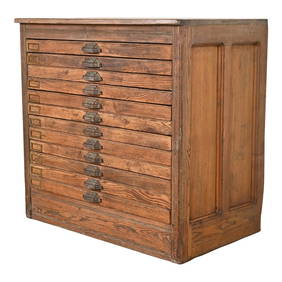
Antique Pine 12-Drawer Blueprint Flat File Cabinet by Hamilton, Circa 1900Liberty & 33rd Furniture Co.4.4(13)See Sold PriceFeb 27, 2024
Antique Arts & Crafts Oak Architect's Blueprint Flat File Cabinet, Circa 1900Liberty & 33rd Furniture Co.4.4(13)See Sold PriceFeb 27, 2024
1863 Thomas Bradbury and Sons, London, circa 1863, the Sterling Silver tray Weight 63.34 OZCV Auction LLC4.4(35)See Sold PriceMar 09, 2024