ATLAS of ANTIENT GEOGRAPHY by SAMUEL BUTLER 1843John McInnis Auctioneers,LLC4.5(505)See Sold PriceFeb 24, 2024
18TH C. ANTIQUE MAP: FRENCH & INDIAN WAR, FRAMEDThomaston Place Auction Galleries4.4(394)See Sold PriceFeb 24, 2024
Rand McNally Railroad Map Cabinet w/ 21 Railroad MapsRail & Road Auctions4.6(165)See Sold PriceMar 08, 2024
Keith Haring - Ink on New York Map, Best Buddies, Inscribed, Signed, and DatedSapphire Auction Gallery4.1(67)See Sold PriceMar 02, 2024
LATE 17TH C. FRENCH MAP OF THE NEW WORLD BY ALEXIS-HUBERT JAILLOT (1632-1712)Thomaston Place Auction Galleries4.4(394)See Sold PriceFeb 24, 2024
Central Railroad of New Jersey Map of Sandy Hook Route-ca. 1903JM Hobby Supply and Railroad Artifact Auctions4.4(127)See Sold PriceFeb 24, 2024
Lot of Six Mixed Atlas Box Cars-HO Scale-New in BoxJM Hobby Supply and Railroad Artifact Auctions4.4(127)See Sold PriceFeb 25, 2024
Rand McNally/Santa Fe Railroad Map of Iowa-1912JM Hobby Supply and Railroad Artifact Auctions4.4(127)See Sold PriceFeb 24, 2024
NICOLAES VISSCHER (NETHERLANDS, 1618-1709) MAP OF THE NEW WORLDThomaston Place Auction Galleries4.4(394)See Sold PriceFeb 24, 2024
17TH C. WORLD MAP BY NICOLAES VISSCHER (NETHERLANDS, 1618-1709)Thomaston Place Auction Galleries4.4(394)See Sold PriceFeb 24, 2024
Lot of Six Mixed Atlas Cabooses-HO Scale-New in BoxJM Hobby Supply and Railroad Artifact Auctions4.4(127)See Sold PriceFeb 25, 2024
SoldChristopher Saxton 1607 Map of ShropshireChristopher Saxton & William Hole 1607 hand colored map of Shropshire from Camden's Brittanica titled "Salopiae Comitatus quen Cornauii", sight view 11 1/4" x 14'See Sold Price
Sold1607 Map of England by Christopher Saxton,handcolored, The Medici Society Ltd. label on back, image area 14" x 12".See Sold Price
SoldANTIQUE MAP OF ENGLAND"Ancient map of England by Christopher Saxton, from Britannica 1607," hand written on reverse. 14.5"H X 16"WSee Sold Price
Shropshire.- Saxton (Christopher) and William HoleShropshire.- Saxton (Christopher) and William Hole Salopiae Comitatus quem Cornauii,county map of Shropshire, cartouche upper right, from Camden's Britannia, engraving with early hand-colourinSee Sold Price
SoldSaxton (Christopher) and Philip Lea ShropshireSaxton (Christopher) and Philip Lea Shropshire,county map with inset bird's-eye view of Shrewsbury, with decorative title cartouche, upper right, engraving with hand-colouring, 395 x 510mm., cSee Sold Price
Saxton: Antique Map of Radnor, Welsh County, 1607Map: Radnor Comitatus Quem Silvres Olim Incoluerunt Publication Date: 1607 ca. Cartographer: SAXTON, CHRISTOPHER/WILLIAM KIP Size: Quarto – 10.30 H x 12.25 W Inches Later quarto size double page fSee Sold Price
Sold* SAXTON, Christopher (ca 1540-ca 1610), and William* SAXTON, Christopher (ca 1540-ca 1610), and William KIP (fl.1598-1610). Flint Comitatus quem ordovices olim Incoluerunt. [London, 1607]. Hand-colored engraved map of Flint, image 265 x 320 mm (320 xSee Sold Price
Saxton: Map of Welsh County Radnor, 1607Map: Radnor Comitatus Quem Silvres Olim Incoluerunt Publication Date: 1607 ca. Maker: SAXTON, CHRISTOPHER/WILLIAM KIP Size: Quarto – 10.30 H x 12.25 W Inches Later quarto size double page folio mapSee Sold Price
* SAXTON, Christopher (ca 1540-ca 1610), and William* SAXTON, Christopher (ca 1540-ca 1610), and William KIP (fl.1598-1610). Flint Comitatus quem ordovices olim Incoluerunt. [London, 1607]. Hand-colored engraved map of Flint, image 265 x 320 mm (320 xSee Sold Price
Radnor Comitatus Quem Silvres Olim IncolueruntTitle/Content of Map: Radnor Comitatus Quem Silvres Olim Incoluerunt Date: 1607 ca. Cartographer: SAXTON, CHRISTOPHER/WILLIAM KIP Size: 10.3X12.25 Later quarto size double page folio map plate by ChriSee Sold Price
SoldSaxton (Christopher) and William Kip. - Bedfordengraved county map with hand-colouring, 280 x 335mm., trimmed on the platemark and laid on support, a small hole near central vertical fold, retouched, 1607 or later § Cary (J.) A Map of Surry froSee Sold Price
Sold-. Kip (William) Devoniae Comitatus,-. Kip (William) Devoniae Comitatus, after Christopher Saxton, engraved map with hand-colouring, 295 x 340mm., central vertical fold, some slightly thinly inked, [c.1607].See Sold Price
SoldSaxton Engraving of of Shropshire, EnglandSAXTON, Christopher (c. 1540 - c. 1610). Salopiae Comitatus, Summa cum Fide cum et Diligentia Descriptionem. Engraved map with original hand color. London: 1579. 16 1/4" x 21 1/2" sheet. Part of ChrisSee Sold Price
Saxton (Christopher) and Philip Lea ShropshireSaxton (Christopher) and Philip Lea Shropshire,title cartouche surmounted by royal arms, upper right, inset plan of Shrewsbury, centre left, engraved map with hand-colouring, 395 x 510mm, sligSee Sold Price
Radnor Comitatus Quem Silvres Olim Incoluerunt, 1607Map: Radnor Comitatus Quem Silvres Olim Incoluerunt Publishing: Christopher/William Kip Saxton, 1607 Size: Quarto, 10.3 x 12.25 inches Later quarto size double page folio map plate by Christopher SaxtSee Sold Price
SoldWilliam Kip after Christopher Saxton mapWilliam Kip after Christopher Saxton map- ''Montgomery''- etching with hand-coloring, 1637, some soft creases in paper. 10 1/2 x 12 1/2''See Sold Price
SoldReduction of Christopher Saxton's map of MonmouthshireHeading: Author: Hole, William Title: Monumethensis Comitatus, quem olim Incoluerunt Silures Place Published: London Publisher: Date Published: 1610 Description: Copper-engSee Sold Price
Sold17th C Kip after Saxton, Map of Wiltoniae17th C. William Kip after Christopher Saxton, Map of Wiltoniae Wiltoniae Comitatus herbida Planiciae nobiis vulgo willshire pars olim Belgarum [Wiltshire] Hand colored copper engraving. Reduced versioSee Sold Price
17th C. Kip after Saxton, Map of Bedford17th C. William Kip after Christopher Saxton, Map of Bedford 'BEDFORD Comitatus' olim pars Cathifuclnorum (Bedfordshire) Hand colored copper engraving, reduced version of original by Saxton from the 1See Sold Price
17th C Kip after Saxton, Map of Dunelmensis17th C William Kip after Christopher Saxton, Map of Dunelmensis, Durham. Dunelmensis Episcopatus (qui comi tatus est Palatinus) olim Brigantum [Durham] Hand colored copper engraving. Reduced version oSee Sold Price
17th C. Kip after Saxton, Map of Cambridge17th C. William Kip after Christopher Saxton, Map of Cambridge, CAMBRIDGE COMITATUS QUEM OLIM ICENI INSEDERUNT Hand colored copper engraving, marked plate 21 in lower left. Reduced version of 1585 oriSee Sold Price
Sold17th C Kip after Saxton, Map of Cumbria17th C William Kip after Christopher Saxton, Map of Cumbria 'CUMBRIA SIVE CUMBERLANDIA QUAE OLIM PARS BRIGANTUM' Hand colored copper engraving. Reduced version of original 1585. Approximately 13 x 11.See Sold Price
17th C Kip after Saxton, Map of Lincolniae17th C William Kip after Christopher Saxton, Map of Lincolniae 'LINCOLNIAE COMITATUS UBI OLIM INSEDERUNT CORITANI' (LINCOLNSHIRE) Hand colored copper engraving of reduced map after Saxtons original 15See Sold Price
17th C Kip after Saxton, Map of Wiltoniae17th C. William Kip after Christopher Saxton, Map of Wiltoniae Wiltoniae Comitatus herbida Planiciae nobiis vulgo willshire pars olim Belgarum [Wiltshire] Hand colored copper engraving. Reduced versioSee Sold Price
Central Railroad of New Jersey Map of Sandy Hook Route-ca. 1903JM Hobby Supply and Railroad Artifact Auctions4.4(127)See Sold PriceFeb 24, 2024
Rand McNally/Santa Fe Railroad Map of Iowa-1912JM Hobby Supply and Railroad Artifact Auctions4.4(127)See Sold PriceFeb 24, 2024
17TH C. WORLD MAP BY NICOLAES VISSCHER (NETHERLANDS, 1618-1709)Thomaston Place Auction Galleries4.4(394)See Sold PriceFeb 24, 2024
LATE 17TH C. FRENCH MAP OF THE NEW WORLD BY ALEXIS-HUBERT JAILLOT (1632-1712)Thomaston Place Auction Galleries4.4(394)See Sold PriceFeb 24, 2024
18TH C. ANTIQUE MAP: FRENCH & INDIAN WAR, FRAMEDThomaston Place Auction Galleries4.4(394)See Sold PriceFeb 24, 2024
NICOLAES VISSCHER (NETHERLANDS, 1618-1709) MAP OF THE NEW WORLDThomaston Place Auction Galleries4.4(394)See Sold PriceFeb 24, 2024
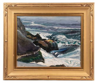
CHRISTOPHER "CHRIS" HUNTINGTON (ME/CAN, 1938 - )Thomaston Place Auction Galleries4.4(394)See Sold PriceFeb 25, 2024
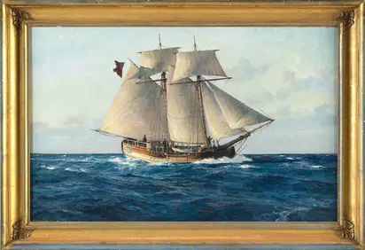
CHRISTOPHER BLOSSOM (Connecticut, 1956-), "Colonial Schooner Halifax"., Oil on canvas, 17" x 27".Eldred's4.7(423)See Sold PriceFeb 27, 2024
Keith Haring - Ink on New York Map, Best Buddies, Inscribed, Signed, and DatedSapphire Auction Gallery4.1(67)See Sold PriceMar 02, 2024
Rand McNally Railroad Map Cabinet w/ 21 Railroad MapsRail & Road Auctions4.6(165)See Sold PriceMar 08, 2024
Putnam - First Map of the State of Ohio by Rufus PutnamTrillium Antique Prints & Rare Books4.5(33)See Sold PriceFeb 24, 2024
1750 Bowen Map of Bermuda and St. Kitts -- A New & Accurate Map of Bermudas or Sommer's Islands...Jasper524.5(9.9k)See Sold PriceFeb 27, 2024
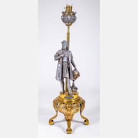
Victorian Christopher Columbus Kerosene Floor LampGray's Auctioneers4.5(187)See Sold PriceMar 06, 2024
Per Olof Christopher Aurivillius (1843-1928) - Set of 3 Prints - ButterfliesProverde Auctions4.3(3)See Sold PriceFeb 28, 2024
Per Olof Christopher Aurivillius (1843-1928) - Set of 3 Prints - Butterflies in SwedenProverde Auctions4.3(3)See Sold PriceFeb 28, 2024
Per Olof Christopher Aurivillius (1843-1928) - Set of 3 Prints - Butterflies - ScandinaviaProverde Auctions4.3(3)See Sold PriceFeb 28, 2024