ATLAS of ANTIENT GEOGRAPHY by SAMUEL BUTLER 1843John McInnis Auctioneers,LLC4.6(504)See Sold PriceFeb 24, 2024
18TH C. ANTIQUE MAP: FRENCH & INDIAN WAR, FRAMEDThomaston Place Auction Galleries4.4(389)See Sold PriceFeb 24, 2024
Rand McNally Railroad Map Cabinet w/ 21 Railroad MapsRail & Road Auctions4.6(165)See Sold PriceMar 08, 2024
Keith Haring - Ink on New York Map, Best Buddies, Inscribed, Signed, and DatedSapphire Auction Gallery4.1(67)See Sold PriceMar 02, 2024
LATE 17TH C. FRENCH MAP OF THE NEW WORLD BY ALEXIS-HUBERT JAILLOT (1632-1712)Thomaston Place Auction Galleries4.4(389)See Sold PriceFeb 24, 2024
Central Railroad of New Jersey Map of Sandy Hook Route-ca. 1903JM Hobby Supply and Railroad Artifact Auctions4.4(126)See Sold PriceFeb 24, 2024
Lot of Six Mixed Atlas Box Cars-HO Scale-New in BoxJM Hobby Supply and Railroad Artifact Auctions4.4(126)See Sold PriceFeb 25, 2024
Rand McNally/Santa Fe Railroad Map of Iowa-1912JM Hobby Supply and Railroad Artifact Auctions4.4(126)See Sold PriceFeb 24, 2024
NICOLAES VISSCHER (NETHERLANDS, 1618-1709) MAP OF THE NEW WORLDThomaston Place Auction Galleries4.4(389)See Sold PriceFeb 24, 2024
17TH C. WORLD MAP BY NICOLAES VISSCHER (NETHERLANDS, 1618-1709)Thomaston Place Auction Galleries4.4(389)See Sold PriceFeb 24, 2024
Lot of Six Mixed Atlas Cabooses-HO Scale-New in BoxJM Hobby Supply and Railroad Artifact Auctions4.4(126)See Sold PriceFeb 25, 2024
Chart of the Viti Group Or Feejee Islands by the U.S.Title/Content of Map: Chart of the Viti Group Or Feejee Islands by the U.S. Ex.Ex. 1840 Date: 1845 Cartographer: YEAGER, EDWARD Publisher: LEA AND BLANCHARD Size: 8.3Height - 11.3Width From Wilkes's NSee Sold Price
Chart of the Viti Group Or Feejee Islands by the U.S.Title: Chart of the Viti Group Or Feejee Islands by the U.S. Ex.Ex. 1840 Printing Date: 1845 Cartographer: YEAGER, EDWARD Publisher: LEA AND BLANCHARD Size: 8.3Height - 11.3Width Additional InformatioSee Sold Price
Chart of the Viti Group Or Feejee Islands by the U.S.Title/Content of Map: Chart of the Viti Group Or Feejee Islands by the U.S. Ex.Ex. 1840 Date Printed: 1845 Cartographer: YEAGER, EDWARD Size: 8.3X11.3 From Wilkes's Narrative of the united States ExplSee Sold Price
Sold(5) Antique Framed Maps of Fiji, Pacific IslandsGroup of (5) framed antique maps of Fiji and surrounding Pacific Islands, including a map "Chart of the Feejee Islands by the U.S. E.x. E.x. 1840" engraved by Edward Yeager in Philadelphia, one "PubliSee Sold Price
Sold1855 Colton Map of Hawaii, New Zealand, Oceania IslandsTitle/Content of Map: 1855 Colton Map of Hawaii, New Zealand, Oceania Islands -- Hawaii or Sandwitch Islands [with] Samoan.. [with] New Zealand [with] Viti Group or Feejee Islands [with] Societi IslanSee Sold Price
SoldMap of Hawaii and New Zealand by Colton, 1855Map features: Hawaiian Group or Sandwich Islands. New Zealand. Viti Group or Feejee Islands. Society Islands. Marquesas or Washington Is. Galapagos Islands. Samoan or Navigators Island. This map is frSee Sold Price
Fiji Islands – Pacific Ocean British Admiralty ChartVery detailed, unused and authentic chart of Ngau Island and Mambulitha Reef in the Fiji or Viti Island Group. With beautiful view on the island. Authentic sea chart, no modern copy. On thick paper, fSee Sold Price
SoldMaps of Various United States of AmericaLarge group of 19th and 20th century maps of parts of the United States. F. H. Gerdes (1809-1884) "U. S. Coast Survey Preliminary Chart of Ship Island Shoal Louisiana" U.S. Coast Survey, Washington DCSee Sold Price
Hawaiian Group or Sandwich Islands | New Zealand | YitiTitle: Hawaiian Group or Sandwich Islands | New Zealand | Yiti Group or Feejee Islands | Society Islands | Marquesas or Washington Is. | Galapacos Islands Publication Date: 1857 Cartographer: G. WoolwSee Sold Price
Sold19th century chart of the Orkney Islands.Early JW Norie chart dated 1826 entitled "Heather's New and Improved Chart of the Orkney Isles, drawn from the most approved surveys." Chart shows this group of islands just above the north coast of SSee Sold Price
Sold10 Maps incl: CHART OF PART OF THE FEEJEE ISLANDS.[Pacific/North America/Misc.] 10 Maps. ++ CHART OF PART OF THE FEEJEE ISLANDS, Explored by Capt; James Wilson, in the Ship Duff. September 1797. London: 1799. Engraved by T. Foot after W. Wilson. ++ ASee Sold Price
SoldMap of the Hawaiian Islands, 1841Title: Map of Hawaiian Group or Sandwich Islands by the U.S. Ex. Ex. 1841 Author: Wilkes, Charles Description: Steel-engraved map. 39.5x60 cm. (15½x23½") plus margins.Well-engraved map of the HawaiiSee Sold Price
Sold1877 chart showing Amelia Island, FloridaAmelia Island, Florida chart. US Coast Survey chart dated 1877 showing the east coast of Florida from the Amelia Island to Halifax River. Matted and framed. 40" high x 22" wide.See Sold Price
Sold(3) EARLY MAPS and a PRINT AFTER WILLIAM BLAKEIncluding: 1886 Fulton's Territory of Alaska, Hawaiian Group or Sandwich Islands, New Zealand, Feejee Islands, 1867 "The World in Two Hemispheres" by Mitchell (colored) and "The Day of Judgement" prinSee Sold Price
South Pacific – Fiji Islands, Easren Group BritishTitle/Content of Map: South Pacific – Fiji Islands, Easren Group British Admiralty Chart 440, published 1883 Date: 1883 Cartographer: British Admiralty Material/Medium: thick paper Size: standard VeSee Sold Price
SoldPuerto Rico, a groupPuerto Rico.- a group documenting the island following its occupation by U.S. troops in July 1898, including views in the country and of San Juan, cockfighting, pounding coffee at Coamo, a boSee Sold Price
Sold4V Rhode Island US REGIONAL HISTORY WashingtonThis auction lot includes the following group of titles: - Waters of the Lonely Way by Ernestine Dunaway Pannes - Dated 1982 by Phoenix - Walks About Washington by Francis E. Leupp - Dated 1915 bySee Sold Price
SoldCOLLECTION OF WWI & WWII LINEMAN SIGNAL CORP TOOLSInteresting group to include Rock Island Armory 1918 pouch and U.S. marked cutting pliers, 1945 Lee pouch with U.S. HPK 1945 marked cutters, lastly U.S. HPK 1944 round head cutter pliers with Lee 1945See Sold Price
COLLECTION OF WWI & WWII LINEMAN SIGNAL CORP TOOLSInteresting group to include Rock Island Armory 1918 pouch and U.S. marked cutting pliers, 1945 Lee pouch with U.S. HPK 1945 marked cutters, lastly U.S. HPK 1944 round head cutter pliers with Lee 1945See Sold Price
SoldNAVIGATIONAL STAR CHART ALEUTIAN ISLANDS MAP CLOTHUSAF CLOTH MAP OF THE ALEUTIAN ISLANDS, ALASKA. 36" SQUARE. (US SHIPPING $5)See Sold Price
SoldFRAMED 1868 CHART FOX ISLANDS THOROUGHFARE, MAINEU.S. Coast Survey, Benjamin Peirce Superintendent, 1868, Scale 20,000, in black and gold frame, matted and glazed, OS: 28 1/2" x 40", SS: 22 3/4" x 34". Damaged on left edge.See Sold Price
SoldALEX HOGG, FRIENDLY ISLANDS CHART MAPSight- 9" x 14 1/2" Overall- 12" x 17 1/2" Shipping U.S. $45 plus insuranceSee Sold Price
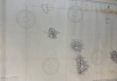
CHART: South Pacific Ocean / SOCIETY ISLANDS – WESTERN GROUP/ HUAHINE TO MAUPITI With theDescription: CHART: South Pacific Ocean / SOCIETY ISLANDS – WESTERN GROUP/ HUAHINE TO MAUPITI With the intermediate islands. Measurement approximate: 28 x 42 InchesSee Sold Price
James Imray and Son - East India Archipelago (Chart No.1872, London 128.5 x 103 cm (51 x 41 in) Showing much of the northern Luzon coast including all of the Batanes and Babuyan group of islands, this extremely scarce commercial sea chart also covers allSee Sold Price
CHART "LONG ISLAND SOUND FROM NEW YORK TO MONTOCK POINT ..." New York, 1830 21" x 77" sight. FramedEldred's4.7(418)See Sold PriceFeb 27, 2024
CHART "SOUTHERN COAST OF LONG ISLAND FROM MONTAUK POINT TO EAST HAMPTON" Circa 1877 11.25" x 22.75"Eldred's4.7(418)See Sold PriceFeb 27, 2024
ELVIS PRESLEY SUCH A NIGHT / NEVER ENDING (R&R 45/PS) #8400.King's Auctions Inc4.1(121)See Sold PriceMar 03, 2024
Oasis Original Rare (What's The Story) Morning Glory?Shakespeare Auctions4.3(1)See Sold PriceFeb 25, 2024
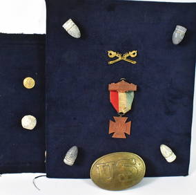
Group of 30+ U.S. Military Patches and MoreMatthew Bullock Auctioneers4.7(1.8k)See Sold PriceFeb 24, 2024
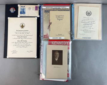
Group of US Presidents inauguration souvenirs, and EphemeraMatthew Bullock Auctioneers4.7(1.8k)See Sold PriceFeb 24, 2024
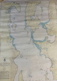
CHART: U.S LAKE SURVEYS/ LAKE CHAMPLAIN/ CUMBERLAND HEAD, NY and SAVAGE ISLAND, VT. TO FOUR BROTHERSChurchill Galleries3.7(216)See Sold PriceFeb 26, 2024
CHART: South Pacific Ocean / SOCIETY ISLANDS - WESTERN GROUP/ HUAHINE TO MAUPITI With theChurchill Galleries3.7(216)See Sold PriceFeb 26, 2024
Lot of 5 Silver Jewelry Including 2 Bezalel StyleWorld Auction Gallery LLC4.7(264)See Sold PriceMar 10, 2024
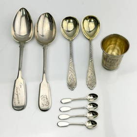
Group Lot of 9 Antique Russian Silver ItemsWorld Auction Gallery LLC4.7(264)See Sold PriceMar 10, 2024
7 Sterling Silver Items Including Georg JensenWorld Auction Gallery LLC4.7(264)See Sold PriceMar 10, 2024