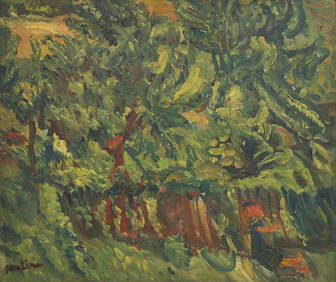
Chaim Soutine (Belarusian/French, 1893-1943) - La Petite Fille dans la VerdureFreeman's | Hindman4.5(158)See Sold PriceFeb 27, 2024
Elisabeth Frink (British, 1930-1993) - Harbinger Bird IFreeman's | Hindman4.5(158)See Sold PriceFeb 27, 2024
AMERICAN SEASCAPE PAINTING BY ROSS EMBROSE MOFFETTAntique Arena Inc.4.5(878)See Sold PriceMar 02, 2024
CHARLES HENRY GIFFORD (Massachusetts, 1839-1904), Luminist view of three sailboats in a quietEldred's4.7(419)See Sold PriceFeb 28, 2024
RARE MANHATTAN PROJECT GLASS LEADED FROM THE MANHATTAN PROJECT WORLD WAR II WW2 724 GRAMSCol. Christie Hatman Auctioneers4.5(333)See Sold PriceFeb 26, 2024
Estate Fresh Civil War Cavalry C. Roby 1863 With ScabbardRalph Fontaine Heritage Auctions Inc.4.7(236)See Sold PriceFeb 25, 2024
ABSTRACT ARAB LEBANESE OIL PAINTING BY ETEL ADNANAntique Arena Inc.4.5(878)See Sold PriceMar 02, 2024
SoldChapman's Sectional Map of the State of Iowa. ComAuthor: Chapman, Silas Lithographed map, hand-colored. 57x82.5 cm. (22½32½"), folding into original decorated boards covers; on the front pastedown is a fold-out table of statistics. Iowa just afterSee Sold Price
SoldChapman SECTIONAL MAP OF THE STATE OF IOWA 1857 DyerDetails: IOWA - CHAPMAN, Silas (1813-1899). Chapman's Sectional Map of the State of Iowa Compiled from the United States Surveys and other authentic Sources. Milwaukee: Dyer & Pasmore, 1857 [lithograSee Sold Price
SoldChapman SECTIONAL MAP OF THE STATE OF IOWA 1868Details: 30] CHAPMAN, Silas (1813-1899). Chapman's Sectional Map of the State of Iowa Compiled from the United States Surveys and other authentic Sources. Milwaukee: Silas Chapman, 1868 [lithographedSee Sold Price
SoldChapman SECTIONAL MAP OF THE STATE OF IOWA 1868Details: CHAPMAN, Silas (1813-1899). Chapman's Sectional Map of the State of Iowa Compiled from the United States Surveys and other authentic Sources. Milwaukee: Silas Chapman, 1868 [lithographed bySee Sold Price
SoldChapman SECTIONAL MAP OF THE STATE OF IOWA 1864 FoldingDetails: IOWA - CHAPMAN, Silas (1813-1899). Chapman's Sectional Map of the State of Iowa Compiled from the United States Surveys and other authentic Sources. Milwaukee: Silas Chapman, 1864. Folding pSee Sold Price
SoldCHAPMAN'S SECTIONAL MAP OF IOWA, 1856CHAPMAN'S SECTIONAL MAP OF IOWA, 1856: Handcolored Map of Iowa in Cloth Covered Book with Gold embossed Title. 5 5/8" x 4" Folds out to 25" x 35". Counties in Alternating Red, Blue Yellow and Green. GSee Sold Price
SoldGeorge Colton SECTIONAL MAP OF THE STATE OF IOWA ColtonDetails: IOWA - COLTON, George W. (1827-1901) & Charles B. (1832-1916). Colton's Sectional Map of the State of Iowa. New York: G.W. & C.B. Colton, 1872. Folding pocket map, full period hand-colouringSee Sold Price
SoldColton's Sectional Map of the State of Iowa CompiAuthor: Colton, G.W. & C.B. Lithographed map, hand-colored. 62.5x90 cm. (24¾x35½") plus decorative border; folding into embossed cloth covers lettered in gilt. Large folding map of Iowa divided intoSee Sold Price
[MAP] Colton’s Sectional Map of the State of Iowa. 1867267. [MAP]. COLTON, J.H, (copyright) & G.W. & C.B. Colton (publisher). Colton’s Sectional Map of the State of Iowa.... New York, 1867. Lithograph map on banknote paper, original full colSee Sold Price
SoldColton's Sectional Map of the State of Iowa CompiAuthor: Colton, G.W. & C.B. Lithographed map, hand-colored. 61.5x90 cm. (24¼x35½") plus decorative border; folding into embossed cloth covers lettered in gilt. Large folding map of Iowa divided intoSee Sold Price
Colton Pocket Map of Iowa, 18641864 Colton Pocket Map of Iowa -- Colton's Sectional Map of the State of Iowa. Attractive lithograph map of Iowa with high level of detail. Counties are colored to add to both visual attactiveness andSee Sold Price
1856 Chapman’s Sectional Map of Wisconsin with theThis large sectional map depicts the state of Wisconsin, just eight years after being admitted into the Union. With the vast majority of the population was in the southeastern portion of the state, SiSee Sold Price
1856 Chapman’s Sectional Map of Wisconsin with theThis large sectional map depicts the state of Wisconsin, just eight years after being admitted into the Union. With the vast majority of the population was in the southeastern portion of the state, SiSee Sold Price
Colton: Pocket Map of Iowa, 1864Map: 1864 Colton Pocket Map of Iowa -- Colton's Sectional Map of the State of Iowa Cartographer: J. Colton Year/Place: 1864 NYC Dimensions: 24 x 35 in. Attractive lithograph map of Iowa with high leveSee Sold Price
Colton: Antique Pocket Map of Iowa, 1864Title: 1864 Colton Pocket Map of Iowa -- Colton's Sectional Map of the State of Iowa Cartographer: J. Colton Year / Place: 1864 NYC Map Dimensions: 24 x 35 in. Condition: Map is good overall with cleaSee Sold Price
SoldColton: Antique Pocket Map of Iowa, 1864Map: 1864 Colton Pocket Map of Iowa -- Colton's Sectional Map of the State of Iowa Date Printed: 1864 NYC Cartographer: J. Colton Size: 24 x 35 in. Condition: Map is good overall with clear and crispSee Sold Price
1864 Colton Pocket Map of Iowa1864 Colton Pocket Map of Iowa -- Colton's Sectional Map of the State of Iowa J. Colton 1864 NYC 24 x 35 in. Attractive lithograph map of Iowa with high level of detail. Counties are colored to add toSee Sold Price
SoldVery large folding map of Iowa 1857Title: A Sectional Map of Iowa compiled from the Official Surveys of the United States... Author: Henn, Williams & Co. Description: Lithographed map, hand-colored. 134.5x170 cm. (53x67"), folding intoSee Sold Price
SoldChapman SECTIONAL MAP OF WISCONSIN 1856 Antique MapDetails: CHAPMAN, Silas (1813-1899). Chapman's Sectional Map of Wisconsin with the most recent surveys. Milwaukee: S. Chapman, 1856 [lithographed by F. Mayer, New York]. Folding pocket map, full periSee Sold Price
Chapman's Sectional Map of Minnesota 1856,Heading: Author: Chapman, Silas Title: Chapman's New Sectional Map of Minnesota Place Published: Milwaukee Publisher:Silas Chapman Date Published: 1856 Description: ColoredSee Sold Price
Chapman's Sectional Map of Minnesota 1856Heading: Author: Chapman, Silas Title: Chapman's Sectional Map of Minnesota Place Published: Milwaukee Publisher:Dyer & Pasmore Date Published: 1856 Description: Large coloSee Sold Price
SoldChapman's Sectional Map of IllinoisAuthor: Chapman, Silas Lithographed map, hand-colored. 100.5x62 cm. (39½x24½"); folding into original gilt-lettered blindstamped cloth covers, 5¾x3¾. Large, detailed map of Illinois, with census oSee Sold Price
Chapman's Sectional Map of Minnesota 1856Heading: Author: Chapman, Silas Title: Chapman's Sectional Map of Minnesota Place Published: Milwaukee Publisher:Dyer & Pasmore Date Published: 1856 Description: Large coloSee Sold Price
Chapman's Sectional Map of Minnesota 1856,Heading: Author: Chapman, Silas Title: Chapman's New Sectional Map of Minnesota Place Published: Milwaukee Publisher:Silas Chapman Date Published: 1856 Description: ColoredSee Sold Price
1892 Adams and Bowles New Road Map of the State of New YorkJM Hobby Supply and Railroad Artifact Auctions4.4(127)See Sold PriceFeb 24, 2024
American Express/New York Central Railroad Map of the United States-1934JM Hobby Supply and Railroad Artifact Auctions4.4(127)See Sold PriceFeb 24, 2024
Crams Colored Railway Map and Shippers Guide of South Dakota 1908-1909JM Hobby Supply and Railroad Artifact Auctions4.4(127)See Sold PriceFeb 24, 2024
Crams Railroad Map of New York-1881JM Hobby Supply and Railroad Artifact Auctions4.4(127)See Sold PriceFeb 24, 2024
Crams Township and Railroad Map of New York-1890JM Hobby Supply and Railroad Artifact Auctions4.4(127)See Sold PriceFeb 24, 2024
Crams Township and Railroad Map of Pennsylvania-1898JM Hobby Supply and Railroad Artifact Auctions4.4(127)See Sold PriceFeb 24, 2024
Northern Pacific RR Washington and Northern Idaho Map Folder-1941JM Hobby Supply and Railroad Artifact Auctions4.4(127)See Sold PriceFeb 24, 2024
Rand McNally Railroad Map of Arizona-1909JM Hobby Supply and Railroad Artifact Auctions4.4(127)See Sold PriceFeb 24, 2024
Rand McNally Railroad Map of Washington-1906JM Hobby Supply and Railroad Artifact Auctions4.4(127)See Sold PriceFeb 24, 2024
Rand McNally/Santa Fe Railroad Map of Iowa-1912JM Hobby Supply and Railroad Artifact Auctions4.4(127)See Sold PriceFeb 24, 2024
Rock Island RR Iowa and Minnesota Lakes Country Brochure-1926JM Hobby Supply and Railroad Artifact Auctions4.4(127)See Sold PriceFeb 24, 2024
17TH C. WORLD MAP BY NICOLAES VISSCHER (NETHERLANDS, 1618-1709)Thomaston Place Auction Galleries4.4(393)See Sold PriceFeb 24, 2024
Vintage County Map Of NY State Plate EngravingThe Benefit Shop Foundation Inc.4.3(2.9k)See Sold PriceFeb 28, 2024
Arrowsmith & Lewis - Map of the United StatesTrillium Antique Prints & Rare Books4.5(32)See Sold PriceFeb 24, 2024
Putnam - First Map of the State of Ohio by Rufus PutnamTrillium Antique Prints & Rare Books4.5(32)See Sold PriceFeb 24, 2024
Carey, pub. 1796 - Map of the Tennassee State formerly part of North Carolina (Tennessee)Trillium Antique Prints & Rare Books4.5(32)See Sold PriceFeb 24, 2024
2 Part Contemporary Sectional Sofa 107" x 107"State Line Auctions & Estate Services4.6(277)See Sold PriceFeb 25, 2024
Map of United States of North America, 1785Antiques Online Auctions4.6(415)See Sold PriceMar 14, 2024


![[Tintype] Massive Bowie knife (1 of 1)](https://p1.liveauctioneers.com/7226/317626/170485482_1_x.jpg?height=282&quality=70&version=1706368022)
![[Ambrotype] Magnificent Portrait (1 of 1)](https://p1.liveauctioneers.com/7226/317626/170485477_1_x.jpg?height=282&quality=70&version=1706368022)


![[Tintype] Native American Man w/ Knife (1 of 2)](https://p1.liveauctioneers.com/7226/317626/170485453_1_x.jpg?height=282&quality=70&version=1706368022)
![[REES, Charles] Enlistedman w/ Bowie Knife (1 of 1)](https://p1.liveauctioneers.com/7226/317626/170485489_1_x.jpg?height=282&quality=70&version=1706368022)
![[Ambrotype] Wounded at Gettysburg (1 of 1)](https://p1.liveauctioneers.com/7226/317626/170485471_1_x.jpg?height=282&quality=70&version=1706368022)


![[Ambrotype] Young Soldier w/ Bowie Knife (1 of 1)](https://p1.liveauctioneers.com/7226/317626/170485459_1_x.jpg?height=282&quality=70&version=1706368022)

![[Daguerreotype] Soldier w/ Bowie Knife (1 of 2)](https://p1.liveauctioneers.com/7226/317626/170485458_1_x.jpg?height=282&quality=70&version=1706368022)
![[Tintype] Soldier w/ Flowers (1 of 1)](https://p1.liveauctioneers.com/7226/317626/170485495_1_x.jpg?height=282&quality=70&version=1706368022)
![[Tintype] Identified North Carolina Infantryman (1 of 2)](https://p1.liveauctioneers.com/7226/317626/170485474_1_x.jpg?height=282&quality=70&version=1706368022)


![[MAP] Colton’s Sectional Map of the State of Iowa. 1867 (1 of 7)](https://p1.liveauctioneers.com/514/38480/16487138_1_x.jpg?height=282&quality=70&version=1363614971)


