ATLAS of ANTIENT GEOGRAPHY by SAMUEL BUTLER 1843John McInnis Auctioneers,LLC4.6(502)See Sold PriceFeb 24, 2024
18TH C. ANTIQUE MAP: FRENCH & INDIAN WAR, FRAMEDThomaston Place Auction Galleries4.4(386)See Sold PriceFeb 24, 2024
Rand McNally Railroad Map Cabinet w/ 21 Railroad MapsRail & Road Auctions4.6(165)See Sold PriceMar 08, 2024
Keith Haring - Ink on New York Map, Best Buddies, Inscribed, Signed, and DatedSapphire Auction Gallery4(67)See Sold PriceMar 02, 2024
LATE 17TH C. FRENCH MAP OF THE NEW WORLD BY ALEXIS-HUBERT JAILLOT (1632-1712)Thomaston Place Auction Galleries4.4(386)See Sold PriceFeb 24, 2024
Central Railroad of New Jersey Map of Sandy Hook Route-ca. 1903JM Hobby Supply and Railroad Artifact Auctions4.4(126)See Sold PriceFeb 24, 2024
Lot of Six Mixed Atlas Box Cars-HO Scale-New in BoxJM Hobby Supply and Railroad Artifact Auctions4.4(126)See Sold PriceFeb 25, 2024
Rand McNally/Santa Fe Railroad Map of Iowa-1912JM Hobby Supply and Railroad Artifact Auctions4.4(126)See Sold PriceFeb 24, 2024
NICOLAES VISSCHER (NETHERLANDS, 1618-1709) MAP OF THE NEW WORLDThomaston Place Auction Galleries4.4(386)See Sold PriceFeb 24, 2024
17TH C. WORLD MAP BY NICOLAES VISSCHER (NETHERLANDS, 1618-1709)Thomaston Place Auction Galleries4.4(386)See Sold PriceFeb 24, 2024
Lot of Six Mixed Atlas Cabooses-HO Scale-New in BoxJM Hobby Supply and Railroad Artifact Auctions4.4(126)See Sold PriceFeb 25, 2024
Central Europe. Germany Poland Czechoslovakia Carpathian Ruthenia TIMES 1922 mapTITLE/CONTENT OF MAP: 'Central European states - Political' Czechoslovakia includes Carpathian Ruthenia, which it administered until it was occupied and annexed by Hungary in 1939; it was subsequentlySee Sold Price
Central Europe. Germany Poland Czechoslovakia Carpathian Ruthenia TIMES 1922 mapTITLE/CONTENT OF MAP: 'Central European states - Political' Czechoslovakia includes Carpathian Ruthenia, which it administered until it was occupied and annexed by Hungary in 1939; it was subsequentlySee Sold Price
Central Europe. Germany Poland Czechoslovakia Carpathian Ruthenia TIMES 1922 mapTITLE/CONTENT OF MAP: 'THE NORTHERN PROVINCES OF SWEDEN AND NORWAY WITH PART I OF RUSSIA' DATE PRINTED: 1874 IMAGE SIZE: Approx 33.5 x 42.0cm, 13.25 x 16.5 inches (Large) TYPE: Antique steel engravedSee Sold Price
Eastern Europe Italian Albania Czechosolvakia Carpathian Ruthenia TIMES 1922 mapTITLE/CONTENT OF MAP: 'Eastern Europe - Communications' Czechoslovakia includes Carpathian Ruthenia, which it administered until it was occupied and annexed by Hungary in 1939; it was subsequently occSee Sold Price
Eastern Europe Italian Albania Czechosolvakia Carpathian Ruthenia TIMES 1922 mapTITLE/CONTENT OF MAP: 'Eastern Europe - Communications' Czechoslovakia includes Carpathian Ruthenia, which it administered until it was occupied and annexed by Hungary in 1939; it was subsequently occSee Sold Price
SoldBartholomew, John 1922 Lot of 8 Large Maps of EuropeIncl Belgium/Holland, Spain/Portugal - East & West, Northern Italy/Austria, Southern Italy, Central European States, Germany - South & West. Large Lithograph Maps Published 1922 by The Times, London fSee Sold Price
Bartholomew, John 1922 Lot of 8 Large Maps of EuropeIncl Belgium/Holland, Spain/Portugal - East & West, Northern Italy/Austria, Southern Italy, Central European States, Germany - South & West. Large Lithograph Maps Published 1922 by The Times, London fSee Sold Price
Sold(ZEMKE'S WOLF PACK) EMERGENCY/ESCAPE SILK MAP(ZEMKE'S WOLF PACK) EMERGENCY/ESCAPE SILK MAP 1: 1,000,000 scale map, depicting north-central Germany, Poland, and Czechoslovakia on one side, and France, Holland, and northwest Germany on the other.See Sold Price
(ZEMKE'S WOLF PACK) EMERGENCY/ESCAPE SILK MAP(ZEMKE'S WOLF PACK) EMERGENCY/ESCAPE SILK MAP 1: 1,000,000 scale maps, depicting north-central Germany, Poland, and Czechoslovakia on one side, and Croatia, Slovakia, Hungary, Germany Italy, and SwitzSee Sold Price
NAZI GERMANY.Growth of the Third Reich. Occupied Poland Sudetenland &c 1940 mapTITLE/CONTENT OF MAP: 'Central Europe: Germany, showing the growth of the Third Reich, and Poland' DATE PRINTED: March 1940 IMAGE SIZE: Approx 27.0 x 43.5cm, 10.75 x 17.25 inches (Large) TYPE: VintageSee Sold Price
SoldBonne: Antique Map of Central Europe, 1780Title/Content of Map: 'L'Allemagne, La Boheme, et La Hongrie; avec une partie de Pologne'. A map of Central Europe from the Baltic Sea to the Gulf of Venice, including present day Germany, Poland, CzeSee Sold Price
L'Allemagne, La Boheme, et La Hongrie; avec…partie de Pologne. BONNE 1780 mapTITLE/CONTENT OF MAP: 'L'Allemagne, La Boheme, et La Hongrie; avec une partie de Pologne' A map of Central Europe from the Baltic Sea to the Gulf of Venice, including present day Germany, Poland, CzecSee Sold Price
NORTH SEA coast chart. East Anglia Kent Holland Flanders. COLLINS 1723 old mapTITLE/CONTENT OF MAP: 'L'Allemagne, La Boheme, et La Hongrie; avec une partie de Pologne' A map of Central Europe from the Baltic Sea to the Gulf of Venice, including present day Germany, Poland, CzecSee Sold Price
SoldBartholomew, John 1922 Lot 7 Maps. Baltic, Germany etcIncl Germany West, Germany East, Southern Scandinavia/Denmark, Poland/Czecho-Slovakia, Siberia, Northern Russia/Finland, Baltic States/East Prussia. Large Lithograph Maps Published 1922 by The Times,See Sold Price
SoldEMERGENCY/ESCAPE SILK MAP OF CENTRAL EUROPEWehrmacht issue 1: 1,000,000 scale map, 33 3/4" x 31", depicting northern Germany, "Protectorate" (Bohemia & Moravia)", northern Slovakia, Poland and Northern Hungary on one side, and Croatia, MonteneSee Sold Price
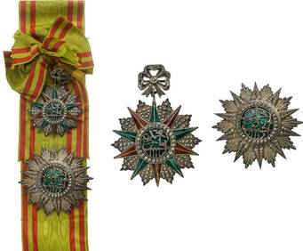
SoldMid-17th C. Central European Steel Winged ZischaggeCentral/Eastern Europe, Germany or Poland, ca. mid-17th century CE. A stunning forged-steel pot helmet used by the legendary winged hussars known as a zischagge ('szyszak' in Polish). The hemisphericaSee Sold Price
Sold1734 ATLAS Vaugondy MAPS Geography Asia Africa Europe1734 ATLAS Vaugondy MAPS Geography Asia Africa Europe USA France Germany Collectors, of both maps and atlases, agree that Vaugondy maps are among the best and most accurate maps! The collection of 18tSee Sold Price
SoldPostage Stamp Collection, Scott InternationalStrong Eastern European collection, mainly Czechoslovakia, Hungary and Poland in very thick Scott International album. From estate collection of long-time dealer/collector. There are several other lotSee Sold Price
SoldWWII NAZI GERMAN ADOLF HITLER SIGNED SECRET MEMOSADOLF HITLER (1889-1945). Leader of Nazi Germany, one of twentieth century's most powerful and feared dictators for a time dominating most of Europe and North Africa. Large group of hand written by AdSee Sold Price
SoldBohemian Glass Vases and Ewer Bohemian Glass Vases and Ewer Central Europe, 19th century. A pair of enameled and gilt decorated vases of narrow baluster form with flaring rims, each having three hand-painted oval reserves of floSee Sold Price
SoldLeszek Piasecki, O/C, Orientalist PaintingLeszek Piasecki (Ukraine/Poland/Germany, 1928-1990) oil on canvas painting of a Middle Eastern marketplace. An Oriental rug trader, standing alongside several carpets, conducts business with two men iSee Sold Price
Munster: Antique Woodcut Map of Europe, 1588Title: Europa das ein Drittheil der Erde nach gelegenheit unserer zeit beschrieben...1588 Münster woodcut and letterpress map of Europe Map maker: Sebastian Münster, Cosmographia Place and Year: BasSee Sold Price
SoldA Late 17th Century Map of Poland, Prussia, LithuaniaNicolaas Visscher after N. Sanson, c.1690, decorative cartouche showing two wind heads, a cheetah’s head and two sets of bows and arrows reads 'abula nova totius Regni Poloniae in quo sunt DucaSee Sold Price
SoldA 17th Century Map of Poland, lithuania, Ukraine,Johannes de Ram, c.1690, titled 'Regni Poloniae et Ducatus Lithuaniae Volhyniae, Podoliae, Ucraniae, Livoniae et Curlandiae, Descriptio, Ementata de Johannes de Ram', Copperplate engraving original unSee Sold Price
Art Deco Malachite Collectible Glass Czechoslovakia Perfume Bottle 1930' H.HoffmannArt Glass Store4.5(60)See Sold PriceMar 03, 2024
Central Railroad of New Jersey Map of Sandy Hook Route-ca. 1903JM Hobby Supply and Railroad Artifact Auctions4.4(126)See Sold PriceFeb 24, 2024
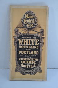
Maine Central RR Through the White Mtns-Portland to the St Lawrence River Book-1901JM Hobby Supply and Railroad Artifact Auctions4.4(126)See Sold PriceFeb 24, 2024
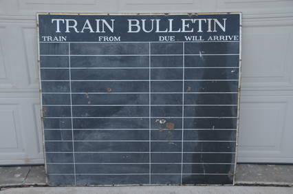
New York Central RR Porcelain Train Bulletin SignJM Hobby Supply and Railroad Artifact Auctions4.4(126)See Sold PriceFeb 24, 2024
Timetable, Paper and Ephemera Lot-Eastern USA RailroadsJM Hobby Supply and Railroad Artifact Auctions4.4(126)See Sold PriceFeb 24, 2024
Art Deco Vaseline Uranium Glass Vintage Necklace SpiderArt Glass Store4.5(60)See Sold PriceMar 03, 2024
Soren Bjulf (Danish,Dutch,1890-1958) oil paintingBroward Auction Gallery4.8(277)See Sold PriceMar 17, 2024
Willy Gordon 21in Judaica Swedish Bronze 1945 WWII Flight with Torah Jewish Statue Stockholm SwedenHess Fine Auctions4.5(197)See Sold PriceMar 02, 2024
LATE 17TH C. FRENCH MAP OF THE NEW WORLD BY ALEXIS-HUBERT JAILLOT (1632-1712)Thomaston Place Auction Galleries4.4(386)See Sold PriceFeb 24, 2024
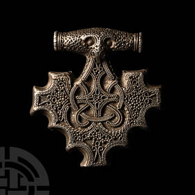
Viking Age Scandinavian Silver Filigree Tau Cross PendantTimeLine Auctions Ltd.4.5(183)See Sold PriceMar 05, 2024
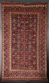
A PERSIAN NAIN RUG CIRCA SECOND QUARTER OF THE 20TH C.Soulis Auctions4.8(953)See Sold PriceFeb 24, 2024
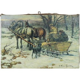
Alfred von Wierusz-Kowalski (1849 - 1915) Polish / Russian Oil Painting Hunters in Horse Drawn SledDonny Malone Auctions4.5(1.7k)See Sold PriceMar 04, 2024
HELMUT NEWTON, TERI ROJAS AND HER SISTER CHERI HAMILTON, SANTA BARABARA, 1984White Knight Auction, Inc4.7(248)See Sold PriceFeb 25, 2024
Vintage German Time & Tide Co Nautical Chronometer And Tide ClockAkiba Galleries4.7(1.7k)See Sold PriceFeb 29, 2024