ATLAS of ANTIENT GEOGRAPHY by SAMUEL BUTLER 1843John McInnis Auctioneers,LLC4.6(502)See Sold PriceFeb 24, 2024
18TH C. ANTIQUE MAP: FRENCH & INDIAN WAR, FRAMEDThomaston Place Auction Galleries4.4(386)See Sold PriceFeb 24, 2024
Rand McNally Railroad Map Cabinet w/ 21 Railroad MapsRail & Road Auctions4.6(165)See Sold PriceMar 08, 2024
Keith Haring - Ink on New York Map, Best Buddies, Inscribed, Signed, and DatedSapphire Auction Gallery4(67)See Sold PriceMar 02, 2024
LATE 17TH C. FRENCH MAP OF THE NEW WORLD BY ALEXIS-HUBERT JAILLOT (1632-1712)Thomaston Place Auction Galleries4.4(386)See Sold PriceFeb 24, 2024
Central Railroad of New Jersey Map of Sandy Hook Route-ca. 1903JM Hobby Supply and Railroad Artifact Auctions4.4(126)See Sold PriceFeb 24, 2024
Lot of Six Mixed Atlas Box Cars-HO Scale-New in BoxJM Hobby Supply and Railroad Artifact Auctions4.4(126)See Sold PriceFeb 25, 2024
Rand McNally/Santa Fe Railroad Map of Iowa-1912JM Hobby Supply and Railroad Artifact Auctions4.4(126)See Sold PriceFeb 24, 2024
NICOLAES VISSCHER (NETHERLANDS, 1618-1709) MAP OF THE NEW WORLDThomaston Place Auction Galleries4.4(386)See Sold PriceFeb 24, 2024
17TH C. WORLD MAP BY NICOLAES VISSCHER (NETHERLANDS, 1618-1709)Thomaston Place Auction Galleries4.4(386)See Sold PriceFeb 24, 2024
Lot of Six Mixed Atlas Cabooses-HO Scale-New in BoxJM Hobby Supply and Railroad Artifact Auctions4.4(126)See Sold PriceFeb 25, 2024
Central America (Southern Part)Title/Content of Map: Central America (Southern Part) Date Printed: 1873 Cartographer: JONES, CHARLES H./THEODORE F. HAMILTON Size: 12.25X17 "Including The United States of Columbia and Venezuela." ShSee Sold Price
Central America (Southern Part)Title/Content of Map: Central America (Southern Part) Date Printed: 1875 Cartographer: HARDESTY, H. H. Size: 12.25X17.75 "including the United States of Columbia" From Jones and Hamilton's HistoricalSee Sold Price
SoldSOUTHERN CENTRAL AMERICA. Mosquito New GranadaTITLE/CONTENT OF MAP: 'Central America (Southern Part) Including Venezuela & New Granada' Date: 1863 IMAGE SIZE: Approx 32.0 x 45.5cm, 12.5 x 18 inches (Large) TYPE: Antique map with original outlineSee Sold Price
SoldSOUTHERN CENTRAL AMERICA. Mosquito New GranadaTITLE/CONTENT OF MAP: 'Central America (Southern Part) Including Venezuela & New Granada' DATE PRINTED: 1862 IMAGE SIZE: Approx 32.0 x 45.5cm, 12.5 x 18 inches (Large) TYPE: Antique map with originalSee Sold Price
Thomson: Antique Map of Spanish North America, 1817TITLE/CONTENT OF MAP: 'Spanish North America, southern part' Central America DATE PRINTED: 1817 IMAGE SIZE: Approx 53.5 x 66.0cm, 21 x 26 inches (Large); Please note that this is a folding map. TYPE:See Sold Price
Thomson: Antique Map of Spanish North America, 1817Title/Content of Map: 'Spanish North America, southern part' Central America Date Printed: 1817 Image Size: Approx 53.5 x 66.0cm, 21 x 26 inches (Large); Please note that this is a folding map. Type:See Sold Price
Partie Meridionale, de L'Ancien Mexique' by RigobertReserve Reduced! TITLE/CONTENT OF MAP: 'Partie Meridionale, de L'Ancien Mexique ou de la Nouv. Le Espagne' A map of the southern Part of Mexico and Central America. The map includes the present-day stSee Sold Price
Partie Meridionale, de L'Ancien Mexique' by RigobertTITLE/CONTENT OF MAP: 'Partie Meridionale, de L'Ancien Mexique ou de la Nouv. Le Espagne' A map of the southern Part of Mexico and Central America. The map includes the present-day states of GuatemalaSee Sold Price
Partie Meridionale, de L'Ancien Mexique' by RigobertTITLE/CONTENT OF MAP: 'Partie Meridionale, de L'Ancien Mexique ou de la Nouv. Le Espagne' A map of the southern Part of Mexico and Central America. The map includes the present-day states of GuatemalaSee Sold Price
SoldMexico and Central AmericaTitle/Content of Map: Mexico and Central America Date: 1863 Cartographer: WELL, J./SHERMAN, G.E. Publisher: MCNALLY'S GEOGRAPHY Size: 8.3Height - 10.5Width Map showing southern part of U.S. Arizona isSee Sold Price
Thomson: Antique Map of Central America, 1817Title/Content of Map: 'Spanish North America, southern part' Date Printed: 1817 Image Size: Approx 53.5 x 66.0cm, 21 x 26 inches (Large); Please note that this is a folding map. Type: Antique early 19See Sold Price
Thomson: Antique Map of Central America, 1817TITLE/CONTENT OF MAP: 'Spanish North America, southern part' DATE PRINTED: 1817 IMAGE SIZE: Approx 53.5 x 66.0cm, 21 x 26 inches (Large); Please note that this is a folding map. TYPE: Antique early 19See Sold Price
SoldSOUTHERN MEXICO & CENTRAL AMERICA Yucatan BelizeTITLE/CONTENT OF MAP: 'NORTH AMERICA, SHEET XVI., THE SOUTHERN PART OF MEXICO, ALSO BELIZE, GUATEMALA, SALVADOR, HONDURAS, NICARAGUA AND COSTA RICA' DATE PRINTED: 1874 IMAGE SIZE: Approx 33.5 x 41.5cmSee Sold Price
Mexico and Central AmericaTitle/Content of Map: Mexico and Central America Date Printed: 1863 Cartographer: WELL, J./SHERMAN, G.E. Size: 8.3X10.5 Map showing southern part of U.S. Arizona is lower half of New Mexico. MarginalSee Sold Price
MAP, Mexico & Central America, PinkertonMexico, Belize & Guatemala. John Pinkerton, Spanish Dominions in North America Middle Part, 1811 (dated). Hand Color. This large, handsome map covers the southern part of Mexico with the Yucatan peninSee Sold Price
Map of Central America 1814Heading: Author: Thomson, John Title: Spanish North America Southern Part Place Published: Edinburgh Publisher: Date Published: [1814] Description: Copper-engraved map, hanSee Sold Price
Thomson: Spanish North America / Central AmericaMap Title: Spanish North America Southern Part. Cartographer: John Thomson Place / Date: Edinburgh / 1816 Size: 24 1/4" x 20" Condition: outline color; overall age toning; some overprinting and browniSee Sold Price
SoldMAP - Central America. PinkertonCentral America. John Pinkerton, Spanish Dominions in North America Southern Part, 1811 (dated). Hand Color. This large, handsome map covers the southern portion of Mexico and Central America from ChiSee Sold Price
SOUTHERN MEXICO & CENTRAL AMERICA Yucatan BelizeTITLE/CONTENT OF MAP: 'NORTH AMERICA, SHEET XVI., THE SOUTHERN PART OF MEXICO, ALSO BELIZE, GUATEMALA, SALVADOR, HONDURAS, NICARAGUA AND COSTA RICA' DATE PRINTED: 1874 IMAGE SIZE: Approx 33.5 x 41.5cmSee Sold Price
SoldMap of Central America 1814Heading: (Map) Author: Thomson, John Title: Spanish North America Southern Part Place Published: Edinburgh Publisher: Date Published: [1814] Description: Copper-engraved map, hanSee Sold Price
PINKERTON, John (1758-1826). Spanish Dominions in NorthPINKERTON, John (1758-1826). Spanish Dominions in North America, Southern Part. Philadelphia: Dobson, ca 1818. Engraved map of Central America, image 506 x 699 mm (sheet 570 x 822 mm), hand-colored inSee Sold Price
Sold1680 Handcolored Map of America by VisscherAuthentic antique hand-tinted map of the (now) southern U.S., Caribbean, Central America and part of South America. Made circa 1680 by Nicholas Visscher. Unframed. Nice condition, with some edge toninSee Sold Price
SoldFaden, William. United States of America Southern PartFaden, William. United States of America Southern Part(London: William Faden, 1814), engraving with outline color and wash; behind mat, unframed. Sheet 22.25 x 33.25 in.; Plate 20 x 27.75 in. From a pSee Sold Price
"Spanish North America, southern part" by John Thomson.TITLE/CONTENT OF MAP: 'Spanish North America, southern part' DATE: 1817 IMAGE SIZE: Approx 53.5 x 66.0cm, 21 x 26 inches (Large); Please note that this is a folding map. TYPE: Antique early 19th centuSee Sold Price
Michigan Southern and Northern Indiana RR 14th Annual Report-February 28, 1869JM Hobby Supply and Railroad Artifact Auctions4.4(126)See Sold PriceFeb 24, 2024
Lake Shore and Michigan Southern RR Special Excursions Timetable-July 7-13, 1892JM Hobby Supply and Railroad Artifact Auctions4.4(126)See Sold PriceFeb 24, 2024
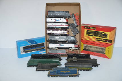
18 Non-Working/Dummy Locomotives-SSW/AMTRAK/ACL/PC/SP/NYC/CO/BO-HO ScaleJM Hobby Supply and Railroad Artifact Auctions4.4(126)See Sold PriceFeb 25, 2024
8" x 8" A+ Male Monarch Butterfly - Danaus PlexippusWeatherham Estate Treasures3.9(157)See Sold PriceMar 07, 2024
8" x 8" Female Monarch Butterfly - Danaus Plexippus (Ventral Side)Weatherham Estate Treasures3.9(157)See Sold PriceMar 07, 2024
South or Central America Santos Wooden Carved Figure with PolychromeDana J. Tharp Auctions4.7(268)See Sold PriceFeb 24, 2024
Three Railroad Lanterns - Gulf Mobile and Ohio, Penn Central, SouthernRail & Road Auctions4.6(165)See Sold PriceMar 07, 2024
ARTS AND CRAFTS HAMMERED LAMP BY FREDRICK FIFIELDAntique Arena Inc.4.5(852)See Sold PriceFeb 24, 2024
6" x 6" Shaded-blue Leafwing Specimen - Prepona Laertes OctaviaWeatherham Estate Treasures3.9(157)See Sold PriceMar 14, 2024
1816 MAP SOUTHERN PART OF RUSSIA or MUSCOVY in EUROPE copper engraving ANTIQUEJasper524.5(9.8k)See Sold PriceFeb 27, 2024
Mexico, Central America and West Indies Physical PoliticalJasper524.5(9.8k)See Sold PriceFeb 27, 2024
Afrique Pays… sud du Lac Tchad 30 Central African Republic VANDERMAELEN 1827 mapJasper524.5(9.8k)See Sold PriceFeb 28, 2024
Historical Stamp Posters "A Glimpse Of The Past"Rapid Estate Liquidators and Auction Gallery4.5(1.1k)See Sold PriceFeb 27, 2024
Historical Stamp Posters "A Glimpse Of The Past"Rapid Estate Liquidators and Auction Gallery4.5(1.1k)See Sold PriceFeb 27, 2024
Choice Florida Agatized Coral Geode & Botryoidal CavityArtemis Fine Arts4.8(1.4k)See Sold PriceMar 01, 2024