ATLAS of ANTIENT GEOGRAPHY by SAMUEL BUTLER 1843John McInnis Auctioneers,LLC4.6(502)See Sold PriceFeb 24, 2024
18TH C. ANTIQUE MAP: FRENCH & INDIAN WAR, FRAMEDThomaston Place Auction Galleries4.4(386)See Sold PriceFeb 24, 2024
Rand McNally Railroad Map Cabinet w/ 21 Railroad MapsRail & Road Auctions4.6(165)See Sold PriceMar 08, 2024
Keith Haring - Ink on New York Map, Best Buddies, Inscribed, Signed, and DatedSapphire Auction Gallery4(67)See Sold PriceMar 02, 2024
LATE 17TH C. FRENCH MAP OF THE NEW WORLD BY ALEXIS-HUBERT JAILLOT (1632-1712)Thomaston Place Auction Galleries4.4(386)See Sold PriceFeb 24, 2024
Central Railroad of New Jersey Map of Sandy Hook Route-ca. 1903JM Hobby Supply and Railroad Artifact Auctions4.4(126)See Sold PriceFeb 24, 2024
Lot of Six Mixed Atlas Box Cars-HO Scale-New in BoxJM Hobby Supply and Railroad Artifact Auctions4.4(126)See Sold PriceFeb 25, 2024
Rand McNally/Santa Fe Railroad Map of Iowa-1912JM Hobby Supply and Railroad Artifact Auctions4.4(126)See Sold PriceFeb 24, 2024
NICOLAES VISSCHER (NETHERLANDS, 1618-1709) MAP OF THE NEW WORLDThomaston Place Auction Galleries4.4(386)See Sold PriceFeb 24, 2024
17TH C. WORLD MAP BY NICOLAES VISSCHER (NETHERLANDS, 1618-1709)Thomaston Place Auction Galleries4.4(386)See Sold PriceFeb 24, 2024
Lot of Six Mixed Atlas Cabooses-HO Scale-New in BoxJM Hobby Supply and Railroad Artifact Auctions4.4(126)See Sold PriceFeb 25, 2024
SoldCarte de la Situation du Paradis TerrestreCarte de la Situation du Paradis TerrestrePrinted in Amsterdam, this is a highly colorful and detailed map of the Holy Land and it’s surroundings. In the center we see Babilonia and Eden, withSee Sold Price
Sold1740 Covens & Mortier Map of Biblical Middle East --Title: 1740 Covens & Mortier Map of Biblical Middle East -- Carte de la Situation du Paradis Terrestre, Et des Pais Habitez par les Patriarches Dressee pour bien entendre l'Histoire Sainte, Par MessirSee Sold Price
1740 Covens & Mortier Map of Biblical Middle East --Title/Content of Map: 1740 Covens & Mortier Map of Biblical Middle East -- Carte de la Situation du Paradis Terrestre, Et des Pais Habitez par les Patriarches Dressee pour bien entendre l'Histoire SaiSee Sold Price
The Middle East. Anonymous. Amsterdam, 18th CenturyCarte de la Situation du Paradis Terrestre et des pais Habitez par les Patriarches Dressee pour bien entendre l'Histoire Sainte. Abraham's journey from Ur to Nablus. In the upper right corner: "GeneseSee Sold Price
Solda group of 5 maps of the Holy Landa group of 5 maps of the Holy Land,including Carte de la Situation du Paradis Terrestre, by Huet; Het Beloofde Landt Canaan, by Wetstein, Smith and Luchtmans; Peregrinatie ofte Veertich-IarigSee Sold Price
SoldArabian Peninsula.- Paradise.- Mortier (Pierre) CarteArabian Peninsula.- Paradise.- Mortier (Pierre) Carte de la Situation du Paradis Terrestre... / Kaart van de Stant van het Aardsch Paradys..., map showing from the Mediterranean through to the PersianSee Sold Price
The Near East. Jan, Luyken. France, c. 1732Carte dela Situation du Paradis Terrestre.../Kaart van de Stant van het Aardsch Paradys. Map of the Holy Land and the Near East. Abraham's journey from Ur to Nablus. According to Pierre Daniel Heut. BSee Sold Price
HUET. Trattato della situazione del paradiso terrestre.HUET, Pierre Daniel. Trattato della situazione del paradiso terrestre.Venezia, G. Albrizzi, 17378vo, 163x115 mm; sewing binding. Frntispiece engraved by C. Orsolini : “La situation du paradis terresSee Sold Price
SoldBonne (Rigobert) Carte de la HollandeBonne (Rigobert) Carte de la Hollande,from 'Atlas de toutes Parties connues du Globe Terrestre', hand-coloured engraving, 225 x 320mm, central vertical fold, minor surface dirt, c.1780 or lateSee Sold Price
SoldWorld.- Sartine, Comte d'Alby (Antoine de) CarteWorld.- Sartine, Comte d'Alby (Antoine de) Carte Reduite Des Parties Connues Du Globe Terrestre Dressee au Depost des Cartes Plans et Journaux de la Marine . . . MDCCLV, large format map of the WorldSee Sold Price
SoldMap locating the Garden of Eden 1722Title: Carte du Paradis Terrestre Suivant le Systeme de Mr. Huet et Execute par P. Starck-man Author: Calmet, Augustin Description: Copper-engraved map. 23.7x20.5 cm. (9¼x8").Eden, or Paridis TerrestSee Sold Price
SoldMap locating the Garden of Eden 1722Title: Carte du Paradis Terrestre Suivant le Systeme de l'Auteur et Execute par P. Starck-man Author: Calmet, Augustin Description: Copper-engraved map. 23.7x22 cm. (9¼x8¾").The Garden of Eden, or PSee Sold Price
SoldMap locating the Garden of Eden 1722Title: Carte du Paradis Terrestre Suivant le Systeme de Mr. Huet et Execute par P. Starck-man Author: Calmet, Augustin Description: Copper-engraved map. 23.7x20.5 cm. (9¼x8"). Eden, or PaSee Sold Price
SoldIZIS. Ensemble de 2 ouvrages ornés de photographieTitle: IZIS. Ensemble de 2 ouvrages ornés de photographies d'Izis. Description: COLETTE. Paradis terrestre. Lausanne, La Guilde du livre, 1953. In-4, broché, jaquette illustrée. PRÉVERT (Jacques).See Sold Price
SoldMarc Chagall (French/Russian, 1887-1985) Two Images"Marc Chagall (French/Russian, 1887-1985) Two Images from the DESSINS POUR LA BIBLE Series, text by Gaston Bachelard: Adam et Eve chassés du Paradis terrestre and Rachel déroSee Sold Price
Two Maps of Palestine - Amsterdam, 1660 ...Two maps, colored by hand, from the book "La Sainte Bible qui contient le Vieux et le Nouveau Testament". [Amsterdam, 1660]. French. 1. Situation du Paradis et du Pays de Canaan. Map of Palestine andSee Sold Price
SoldDelamarche, Felix 1829 Map of World Hemispheres"Mappe-Monde ou Carte Generale du Globe Terrestre" Copper Engraved Map Published 1829, Paris for "Atlas de La Geographie..." by Felix Delamarche. Contemporary outline hand colour. Centre fold as publiSee Sold Price
SoldAtlanteAtlas Moderne ou Collection de cartes sur toutes les parties du Globe Terrestre Parigi, Lattré Graveur e Herissant, [1762]. In 2°. Frontespizio allegorico inciso in rame, carta con la sfera armiSee Sold Price
SoldLOUIS CLAUDE DE VEZOU 1760Mappe-Monde Geo Spherique ou Nouvelle Carte Ideale Du Globe Terrestre Pour servir d'Introduction a la Geographie, L'Hydrographie, et a la Sphere Armillaire . . . 1760 Hand color engraving on paper DimSee Sold Price
EUROPE. Carte de la Vallée du Danube. Germany Austria Czech Republic 1859 mapTITLE/CONTENT OF MAP: 'Carte de la Vallée du Danube ' DATE PRINTED: 1859 IMAGE SIZE: Approx 21.5 x 35.5cm, 8.5 x 13.75 inches (Large) TYPE: Antique engraved map CONDITION: Good; suitable for framSee Sold Price
EUROPE. Carte de la Vallée du Danube. Germany Austria Czech Republic 1859 mapTITLE/CONTENT OF MAP: 'Carte de la Vallée du Danube ' DATE PRINTED: 1859 IMAGE SIZE: Approx 21.5 x 35.5cm, 8.5 x 13.75 inches (Large) TYPE: Antique engraved map CONDITION: Good; suitable for framSee Sold Price
SoldNicolas de Fer world mapCartographer: Nicholas de Fer Title: Carte de la Mer du Sud, et des Costes d’Amerique et d’Asie, Situees sur cette Mer .... [in set with] Carte de la Mer du Nord, et des Costes d’Amerique, d'EurSee Sold Price
SoldTardieu (Pierre François) - A group of 4 maps of theCarte de l'Isle de Cuba et des Isles Lucayes; Carte de la Golfe du Mexique et des Isles Antilles; Carte des Isles de la Jamaïque et de St. Domingue; Carte des Antilles, engraved maps with originalSee Sold Price
SoldDezauche (J.A.) Province du LanguedocDezauche (J.A.) Carte de la Province du Languedoc, Partie Meridionale comprenant le Roussillon et le Comté de Foix; Partie Septentrionale comprenant le Rouergue et le Quercy,Languedoc region oSee Sold Price
RIGOBERT BONNE c1787 Original Colored Map Germany & Region 15" x 12"Luis Porretta Fine Arts4.3(10)See Sold PriceMar 02, 2024
[MAPS]. DUFOUR, Auguste-Henri (1795-1865). Bound Volume of ...Potter & Potter Auctions4.6(539)See Sold PriceMar 07, 2024
Map of St. Kitts and Nevis Depot de la Marine, Paris, 1758Global Auctions Company4.3(36)See Sold PriceMar 03, 2024
Duval - Pair: Map of Georgia & Map of Moscow, RussiaTrillium Antique Prints & Rare Books4.5(30)See Sold PriceFeb 24, 2024
Duval - Pair: Map of India & Map of MaldivesTrillium Antique Prints & Rare Books4.5(30)See Sold PriceFeb 24, 2024
Partie de la Coste d'Afrique depuis Tanit…' Southern Mauritania BELLIN 1746 mapJasper524.5(9.8k)See Sold PriceFeb 28, 2024
Partie de la Coste d'Afrique'. Southern Mauritania BELLIN/SCHLEY 1747 old mapJasper524.5(9.8k)See Sold PriceFeb 28, 2024
Carte de la Guinée, contenant…'. Guinea & Cape Verde islands. BONNE 1771 mapJasper524.5(9.8k)See Sold PriceFeb 28, 2024
Côte occidentale de l'Afrique. W Africa.Senegal Gambia rivers.D’ANVILLE 1751 mapJasper524.5(9.8k)See Sold PriceFeb 28, 2024
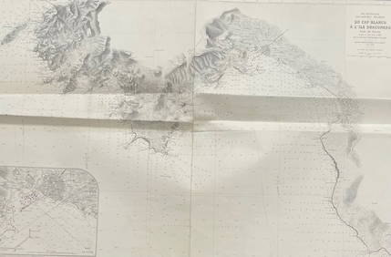
MER MEDITERRANEE ILES BALEARES MAJORQUE/ DU CAP BLANCO A L'ILE DRACONERA/ 1890Churchill Galleries3.7(213)See Sold PriceFeb 26, 2024
MER MEDITERRANEE / CORSE DU CAP PERTUSATO A LA POINTE DE SENETOSE LES MOINES Carte levee en 1884 etChurchill Galleries3.7(213)See Sold PriceFeb 26, 2024
Barthelemy, Jean 1790 Map. Greece - Essa sur la Bataille de PlateeAlbion Auctions4.6(336)See Sold PriceMar 01, 2024


![[MAPS]. DUFOUR, Auguste-Henri (1795-1865). Bound Volume of ... (1 of 2)](https://p1.liveauctioneers.com/928/318880/171361279_1_x.jpg?height=282&quality=70&version=1707501302)