ATLAS of ANTIENT GEOGRAPHY by SAMUEL BUTLER 1843John McInnis Auctioneers,LLC4.6(502)See Sold PriceFeb 24, 2024
18TH C. ANTIQUE MAP: FRENCH & INDIAN WAR, FRAMEDThomaston Place Auction Galleries4.4(386)See Sold PriceFeb 24, 2024
Rand McNally Railroad Map Cabinet w/ 21 Railroad MapsRail & Road Auctions4.6(165)See Sold PriceMar 08, 2024
Keith Haring - Ink on New York Map, Best Buddies, Inscribed, Signed, and DatedSapphire Auction Gallery4(67)See Sold PriceMar 02, 2024
LATE 17TH C. FRENCH MAP OF THE NEW WORLD BY ALEXIS-HUBERT JAILLOT (1632-1712)Thomaston Place Auction Galleries4.4(386)See Sold PriceFeb 24, 2024
Central Railroad of New Jersey Map of Sandy Hook Route-ca. 1903JM Hobby Supply and Railroad Artifact Auctions4.4(126)See Sold PriceFeb 24, 2024
Lot of Six Mixed Atlas Box Cars-HO Scale-New in BoxJM Hobby Supply and Railroad Artifact Auctions4.4(126)See Sold PriceFeb 25, 2024
Rand McNally/Santa Fe Railroad Map of Iowa-1912JM Hobby Supply and Railroad Artifact Auctions4.4(126)See Sold PriceFeb 24, 2024
NICOLAES VISSCHER (NETHERLANDS, 1618-1709) MAP OF THE NEW WORLDThomaston Place Auction Galleries4.4(386)See Sold PriceFeb 24, 2024
17TH C. WORLD MAP BY NICOLAES VISSCHER (NETHERLANDS, 1618-1709)Thomaston Place Auction Galleries4.4(386)See Sold PriceFeb 24, 2024
Lot of Six Mixed Atlas Cabooses-HO Scale-New in BoxJM Hobby Supply and Railroad Artifact Auctions4.4(126)See Sold PriceFeb 25, 2024
Carte de l'Isle St. Christophe'. Saint Kitts/St Christopher. BELLIN 1760 mapTITLE/CONTENT OF MAP: 'Carte de l'Isle St. Christophe. Pour servir a l'histoire Génle. des voyages par M. B. Ing. De la Marine [Map of the island of St Kitts, for inclusion in the "Histoire GenerSee Sold Price
Carte de l'Isle St. Christophe'. Saint Kitts/St Christopher. BELLIN 1760 mapTITLE/CONTENT OF MAP: 'Carte de l'Isle St. Christophe. Pour servir a l'histoire Génle. des voyages par M. B. Ing. De la Marine [Map of the island of St Kitts, for inclusion in the "Histoire GenerSee Sold Price
Bellin: Antique Map of Saint Kitts Island, 1758Title/Content of Map: 'Carte de l'Isle St. Christophe Pour servir à l'Histoire Générale des Voyages par M. B. Ingr. de la Marine' A map of the Caribbean island of Saint Kitts (or St Christopher), aSee Sold Price
l'Isle St. Christophe Caribbean Map, Bellin, 1758TITLE OF THE MAP: 'Carte de l'Isle St. Christophe Pour servir à l'Histoire Générale des Voyages par M. B. Ingr. de la Marine' A map of the Caribbean island of Saint Kitts (or St Christopher), and tSee Sold Price
J.N. Bellin: Map of St. Christopher Island, 1758Carte Réduite De L'Isle De Saint Christophe is a highly detailed large-scale engraved map of St. Christopher island (a.k.a. St. Kitts) with topography, several place names, and a beautiful title cartSee Sold Price
Sold[Map, Large] Island of St. Christopher, 1758Bellin. "Carte Reduite de L'Isle de Saint Christophe…." Paris, 1758. Measured from plate-marks 35.5" x 24". Hand-colored, on laid. Two holes near crease, some repairs to verso (refer to photos), cleSee Sold Price
Carte de l'Isle St. Christophe'. Saint Kitts/StTITLE/CONTENT OF MAP: 'Carte de l'Isle St. Christophe. Pour servir a l'histoire Génle. des voyages par M. B. Ing. De la Marine [Map of the island of St Kitts, for inclusion in the "Histoire GeneralSee Sold Price
Carte de l'Isle de St Christophle'. St Christopher / St Kitts. BELLIN 1759 mapTITLE/CONTENT OF MAP: 'Carte de l'Isle de St Christophle [Map of the island of St Christopher (St Kitts)]' DATE PRINTED: 1759 IMAGE SIZE: Approx 20.5 x 32.0cm, 8 x 12.5 inches (Large); Please note thaSee Sold Price
Carte de l'Isle de St Christophle'. St Christopher / St Kitts. BELLIN 1759 mapTITLE/CONTENT OF MAP: 'Carte de l'Isle de St Christophle [Map of the island of St Christopher (St Kitts)]' DATE PRINTED: 1759 IMAGE SIZE: Approx 20.5 x 32.0cm, 8 x 12.5 inches (Large); Please note thaSee Sold Price
1764 Bellin Map of St. Kitts -- Carte de l'Isle St. ChristopheTitle: 1764 Bellin Map of St. Kitts -- Carte de l'Isle St. Christophe Cartographer: J Bellin Year / Place: 1764, Paris Map Dimension (in.): 7.9 X 13.2 in. This is a lovely map of St. Kitts in Lesser ASee Sold Price
1764 Bellin Map of St. Kitts -- Carte de l'Isle St. ChristopheTitle: 1764 Bellin Map of St. Kitts -- Carte de l'Isle St. Christophe Cartographer: J Bellin Year / Place: 1764, Paris Map Dimension (in.): 7.9 X 13.2 in. This is a lovely map of St. Kitts in Lesser ASee Sold Price
SoldBellin: Antique Map of Saint Kits, 1754Map: Carte de l'Isle St. Christophle Cartographer: Bellin Place & Date: Paris / 1754/1760 Size: 12 1/8" x 7 5/8" Condition: b&w; light overall age toning; a tiny repaired puncture hole in the lower leSee Sold Price
Jacques-Nicolas Bellin (1703-1772), "Carte de l'isle St. Christophe" (Map of the island of StColored copper engraved map on paper, unsigned, 1764, below the depiction inscribed "Tom XV in 4?, no. 11. Tome 15. in 8?, Page 522.", top right title cartouche, mile pointer top left, map of the CariSee Sold Price
Sold1759 Bellin Map Carte De L'isle De Saint DomingueMap of “Carte De L'Isle De Saint Domingue Pour Servir A L'histoire Generale Des Voyages Par M. B. Ing. De La Marine” By Jacques Bellin, , Printed At Paris 1759. Fine, Measures 15.5 X 10”. PleaseSee Sold Price
Sold1760 Bellin Map of Reunion -- Carte de l' Isle deTitle/Content of Map: 1760 Bellin Map of Reunion -- Carte de l' Isle de Bourbon autrefois Mascareigne Cartographer: J Bellin Year/Place: 1760 c., Paris Size: 8 X 9.4 in. This is an excellent map of thSee Sold Price
SoldMaps, L'isle St. Christophe and L'isle de Sainte Lucie(lot of 2) Maps, "Carte de de L'isle St. Christophe," and "Carte de L'isle de Sainte Lucie," engravings with hand-coloring, overall (framed/each): 13"h x 17"wSee Sold Price
SoldBellin: Hispaniola Dominican Republic & Haiti, 1780Map: 1780 Bellin Map of Hispaniola (Dominican Republic and Haiti) -- Carte de l'Isle de Saint Domingue, pour Servir a l'Histoire Generale des Voyages Cartographer: J Bellin Year / Place: 1780 c., PariSee Sold Price
SoldBellin: Antique Map of Saint Croix/Puerto Rico, 1764Map: Carte de l'Isle de Sainte Croix / Carte de l'Isle de Saint Jean de Portorico Cartographer: Bellin Place & Date: Paris / 1764 Size: 6 3/4" x 8 3/4" Condition: outline and background wash color; ovSee Sold Price
Bellin: Antique Map of St. Thomas, 1764Map: Carte de l'Isle de St. Thomas l'Une des Vierges Cartographer: Jacques Nicolas Bellin Place & Date: Paris / 1764 Size: 14" X 8 1/2" Condition: wash color; overall age toning within lighter margin;See Sold Price
SoldBellin map of St. Lucia in the Caribbean 1758Title: Carte de l'Isle de Sainte Lucie, pour Servir a l'Histoire Generale des Voyages... Author: Bellin, Jacques Nicolas Description: Copper-engraved map, modern hand-coloring. 19x29.5 cm. (7½x11¾")See Sold Price
Bellin map of St. Lucia in the Caribbean 1758Title: Carte de l'Isle de Sainte Lucie, pour Servir a l'Histoire Generale des Voyages... Author: Bellin, Jacques Nicolas Description: Copper-engraved map, modern hand-coloring. 19x29.5 cm. (7½x11¾")See Sold Price
1764 Bellin Map of St. Lucia in Lesser Antilles -- Carte de l'Isle de Sainte LucieTitle: 1764 Bellin Map of St. Lucia in Lesser Antilles -- Carte de l'Isle de Sainte Lucie Cartographer: J Bellin Year / Place: 1764, Paris Map Dimension (in.): 8.2 X 12.3 in. This is an attractive mapSee Sold Price
1764 Bellin Map of St. Lucia in Lesser Antilles -- Carte de l'Isle de Sainte LucieTitle: 1764 Bellin Map of St. Lucia in Lesser Antilles -- Carte de l'Isle de Sainte Lucie Cartographer: J Bellin Date/Place: 1764, Paris Dimensions: 8.2 X 12.3 in. Description: This is an attractive mSee Sold Price
Bellin map of St. Lucia in the Caribbean 1758Title: Carte de l'Isle de Sainte Lucie, pour Servir a l'Histoire Generale des Voyages... Author: Bellin, Jacques Nicolas Description: Copper-engraved map, modern hand-coloring. 19x29.5 cm. (7½x11¾")See Sold Price
LARGE LATE 17TH C. DUTCH CHART OF CANADA, GREAT LAKES, NEW FRANCE, LABRADOR, HUDSON BAY, BY PIERREThomaston Place Auction Galleries4.4(386)See Sold PriceFeb 24, 2024
EARLY 18TH C. DUTCH CHART OF PACIFIC OCEAN BY FREDERIK DE WIT (1629-1706) WITH CALIFORNIA AS ANThomaston Place Auction Galleries4.4(386)See Sold PriceFeb 24, 2024
LARGE EARLY 18TH C. DUTCH CHART OF UPPER NORTH AMERICA, PIERRE MORTIER (1661-1711), FRAMEDThomaston Place Auction Galleries4.4(386)See Sold PriceFeb 24, 2024
Spanish school of the 19th century. After PIETER PAUL RUBENS (Siegen, Germany, 1577 - Antwerp,Setdart Auction House4.1(22)See Sold PriceFeb 28, 2024
A Mexican Retablo of St. Rita de Cascia.Turner Auctions + Appraisals4.3(311)See Sold PriceFeb 24, 2024
A Mexican Retablo of St. Camillus de Lellis.Turner Auctions + Appraisals4.3(311)See Sold PriceFeb 24, 2024
[MAPS]. DUFOUR, Auguste-Henri (1795-1865). Bound Volume of ...Potter & Potter Auctions4.6(539)See Sold PriceMar 07, 2024
Map of St. Kitts and Nevis Depot de la Marine, Paris, 1758Global Auctions Company4.3(36)See Sold PriceMar 03, 2024
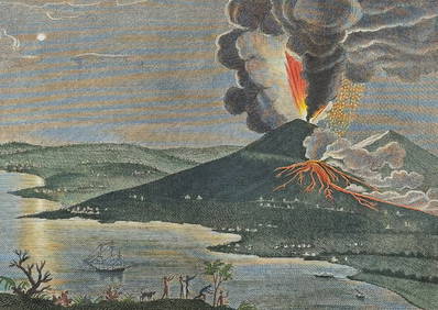
Filomarino - Mount Vesuvius Volcano Erupting. 6Trillium Antique Prints & Rare Books4.5(30)See Sold PriceFeb 24, 2024
Karl Bodmer - Scalp Dance of the Minatarres. 27Trillium Antique Prints & Rare Books4.5(30)See Sold PriceFeb 24, 2024
1760 MAP CARTE PARTICULIERE DE L'ISLE DE JUAN FERNANDES antique Robinson CrusoeJasper524.5(9.8k)See Sold PriceFeb 27, 2024
1764 Bellin Map of Eastern Guadeloupe in the Lesser Antilles -- Partie Orientale de l'Isle de laJasper524.5(9.8k)See Sold PriceFeb 27, 2024
1764 Bellin Map of Mari-Galante Near Guadeloupe -- Carte de l'Isle de Mari-GalanteJasper524.5(9.8k)See Sold PriceFeb 27, 2024
1764 Bellin Map of St. Kitts -- Carte de l'Isle St. ChristopheJasper524.5(9.8k)See Sold PriceFeb 27, 2024
1764 Bellin Map of Antigua -- Carte de l'Isle d'Antigue Situee par la Latitude 17 Degres et par laJasper524.5(9.8k)See Sold PriceFeb 27, 2024
1764 Bellin Map of Port Antonio, Jamaica -- Plan des Havres de Port Antonio et de Saint FrancoisJasper524.5(9.8k)See Sold PriceFeb 27, 2024


![[Map, Large] Island of St. Christopher, 1758 (1 of 4)](https://p1.liveauctioneers.com/3532/146911/74242534_1_x.jpg?height=282&quality=70&version=1564368564)


![[MAPS]. DUFOUR, Auguste-Henri (1795-1865). Bound Volume of ... (1 of 2)](https://p1.liveauctioneers.com/928/318880/171361279_1_x.jpg?height=282&quality=70&version=1707501302)