SoldCaptain Cooks Map of the World, c. 1784Historic Maps"A New General Chart of the World", with Traces of Captain Cook's Voyages, by Conder c. 1784, Map Print Entitled: "A NEW GENERAL CHART OF THE WORLD", Captain Cook'See Sold Price
Sold18th c. Map18th c. map of the world marked "A Chart of the World according to Mercators Projection shewing the latest discoveries of Captain Cook", 18th c. printing.See Sold Price
SoldMathew Carey (19th c.mapmaker) "A Map of the WorlMathew Carey (19th c.mapmaker) "A Map of the World from the best Authorities," hand colored copper engraving, ca. 1818, 12"x 21," framed 25"x 34," label verso, Shows the track of Captain Cooks voyagesSee Sold Price
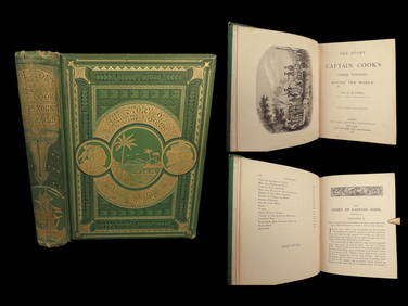
Sold[COOK, James], The Voyages Of Captain[COOK, James]. The Voyages Of Captain James Cook Round The World, Illustrated with Maps and Numerous Engravings on Wood and Steel. 2 Vols in 1. Lon: John Tallis & Co., c.1854 [ink inscription date onSee Sold Price
SoldCOOK (Captain James) and G.WCOOK (Captain James) and G.W. ANDERSON. A New, Authentic and Complete Collection of Voyages round the World, London: Alex Hogg 1784, folio, portrait frontispiece, folding map and first few leaves a liSee Sold Price
Sold[TRAVEL & EXPLORATION]. [COOK, James, Captain[TRAVEL & EXPLORATION]. [COOK, James, Captain (1728-1779)]. ANDERSON, George William. New, Authentic, and Complete Collection of Voyages Round the World.... London: for Alex Hogg, [1784-1786]. Folio (See Sold Price
Chart of the World… Tracks Discoveries of Captain CookLithograph map in color, published by William Guthrie(London c 1811) published in Guthrie's Geography Atlas showing the latest discoveries of Captain Cook 14 x 19 inchesSee Sold Price
Chart of the World… Tracks Discoveries of CaptainLithograph map in color, published by William Guthrie (London c 1811) published in Guthrie's Geography Atlas showing the latest discoveries of Captain Cook 14 x 19 inchesSee Sold Price
SoldCooks Voyages with maps by TallisHeading: Author: Cook, James Title: The Voyages of Captain James Cook Round the World Place Published: London & New York Publisher:James Tallis & Company Date Published: c.1860 DescripSee Sold Price
SoldCAPTAIN JAMES COOK MAP OF THE WORLDJAMES COOK, (1728-1779), one of the most famous and successful British explorers, made three scientific and navigational voyages to the Pacific Ocean. Map. 19" x 15". An interesting New General CharteSee Sold Price
Soldc. 1781, Map: Captain Cook VoyagesMapsc. 1781, Map “A Chart and Views of Pitcairns Island", Extremely Fine. Overall size 9" x 15.25" (the actual printed area is smaller). Published in London by Alexander Hogg for use as an illusSee Sold Price
Soldc. 1781, Map: Captain Cook VoyagesMapsc. 1781, Map “A Chart and Views of Pitcairns Island", Extremely Fine. Overall size 9" x 15.25" (the actual printed area is smaller). Published in London by Alexander Hogg for use as an illusSee Sold Price
Soldc. 1781, Map: Captain Cook VoyagesMapsc. 1781, Map “A Chart and Views of Pitcairns Island", Extremely Fine. Overall size 9" x 15.25" (the actual printed area is smaller). Published in London by Alexander Hogg for use as an illusSee Sold Price
SoldFive Maps of Northwest America, c. 1781MapsFive Captain Cook Voyage Maps of Northwest America c. 1781, Five Maps of Northwest America describing Capt. James Cook’s voyages, Choice Very Fine. Published in London by Alexander Hogg forSee Sold Price
SoldFive Maps of Northwest America, c. 1781Historic MapsFive Captain Cook Voyage Maps of Northwest America c. 1781, Five Maps of Northwest America describing Capt. James Cook's voyages, Choice Very Fine. Published in London by Alexander HoSee Sold Price
SoldFive Maps of Northwest America, c. 1781Historic MapsFive Captain Cook Voyage Maps of Northwest America c. 1781, Five Maps of Northwest America describing Capt. James Cook's voyages, Choice Very Fine. Published in London by Alexander HoSee Sold Price
SoldFive Maps of Northwest America, c. 1781Historic MapsFive Captain Cook Voyage Maps of Northwest America c. 1781, Five Maps of Northwest America describing Capt. James Cook's voyages, Choice Very Fine. Published in London by Alexander HoSee Sold Price
SoldFive Maps of Northwest America, c. 1781Historic MapsFive Captain Cook Voyage Maps of Northwest America c. 1781, Five Maps of Northwest America describing Capt. James Cook’s voyages, Choice Very Fine. Published in London by AlexanderSee Sold Price
SoldFive Maps of Northwest America, c. 1781MapsFive Captain Cook Voyage Maps of Northwest America c. 1781, Five Maps of Northwest America describing Capt. James Cook’s voyages, Choice Very Fine. Published in London by Alexander Hogg forSee Sold Price
SoldFive Maps of Northwest America, c. 1781Historic MapsFive Captain Cook Voyage Maps of Northwest America c. 1781, Five Maps of Northwest America describing Capt. James Cook's voyages, Choice Very Fine. Published in London by Alexander HoSee Sold Price
Old 18th Century World Map Displaying TracksOLD 18th CENTURY WORLD MAP DISPLAYING TRACKS of CAPTAIN COOK Engraved by T BROWN OLD 18th CENTURY WORLD MAP DISPLAYING TRACKS of CAPTAIN COOK Engraved by T BROWN Description Circa 1768-1787 Antique WoSee Sold Price
Polar.- Captain Cook.- Bell (Andrew) Geography A Map ofPolar.- Captain Cook.- Bell (Andrew) Geography A Map of the World in Three Sections, Describing the Polar Regions to the Tropics In Which Are Traced the Tracts of Lord Mulgrave and Captain Cook TowardSee Sold Price
SoldC. 1779, ANTARCTICA & CAPTAIN COOK'S TRAVELS MAPAntonio Zatta (Italian fl. 1775-1797), "Emisfero Terrestre Meridionale Tagliato su l'Equatore", circa 1779, hand colored etching on paper depicting map of Antarctica and Captain Cook's travels, unframSee Sold Price
Soldc.1781 Two Maps: Captain Cook VoyagesHistoric Maps c. 1781, Dual Map “A Plan of Success Bay in Strait Le Maire / A Chart of the S.E. part of Terra del Fuego, including Strait le Maire and part of Staten Land by Captn. Cook 1769", ExtreSee Sold Price
1789 Captain James Cook Life & Voyages Australia New Zealand Hawaii KippisSchilb Antiquarian Rare Books4.8(428)See Sold PriceMar 10, 2024
1871 Captain Cook Voyages Around the World Tahiti Hawaii Exploration AntarcticaSchilb Antiquarian Rare Books4.8(428)See Sold PriceMar 10, 2024
17TH C. WORLD MAP BY NICOLAES VISSCHER (NETHERLANDS, 1618-1709)Thomaston Place Auction Galleries4.4(393)See Sold PriceFeb 24, 2024
LATE 17TH C. FRENCH MAP OF THE NEW WORLD BY ALEXIS-HUBERT JAILLOT (1632-1712)Thomaston Place Auction Galleries4.4(393)See Sold PriceFeb 24, 2024
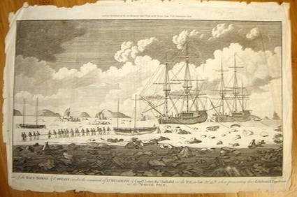
ALEXANDER HOGG ca1790 Engraving Captain Mulgrave Ships Ice Bound Cpt CookLuis Porretta Fine Arts4.3(10)See Sold PriceMar 02, 2024
1816 MAP SOUTHERN PART OF RUSSIA or MUSCOVY in EUROPE copper engraving ANTIQUEJasper524.5(9.9k)See Sold PriceFeb 27, 2024
1816 MAP NORTHERN PART OF RUSSIA or MUSCOVY in EUROPE copper engraving ANTIQUEJasper524.5(9.9k)See Sold PriceFeb 27, 2024
Vintage Holy Bible Old & New Testaments Illustrated 1904The Benefit Shop Foundation Inc.4.3(2.9k)See Sold PriceMar 13, 2024
3 Vintage The World Lithographs, By JanssonThe Benefit Shop Foundation Inc.4.3(2.9k)See Sold PriceMar 13, 2024


![[COOK, James], The Voyages Of Captain (1 of 1)](https://p1.liveauctioneers.com/179/10308/2350557_1_x.jpg?height=282&quality=70)

![[TRAVEL & EXPLORATION]. [COOK, James, Captain (1 of 4)](https://p1.liveauctioneers.com/197/168691/85058430_1_x.jpg?height=282&quality=70&version=1589391499)