Vintage Ca. 1940's International Panel Delivery Truck Converted into Stationary Food Truck, WasSwisher Bros. Auction LLC4.4(241)See Sold PriceFeb 25, 2024
Martin Custom Acoustic Guitar 000 Body Style Rosewood with Hard CaseHess Fine Auctions4.5(197)See Sold PriceMar 02, 2024
1968 Gibson LG-0 Acoustic Dreadnought Parlor GuitarHess Fine Auctions4.5(197)See Sold PriceMar 02, 2024
Replica Robinson 1862 Sharps CarbineSchmidt's Antiques Inc. Since 19114.8(431)See Sold PriceMar 02, 2024
PAIR (18th c) OF FLINTLOCK DUELING PISTOLSJohn McInnis Auctioneers,LLC4.6(502)See Sold PriceFeb 24, 2024
PAIR T KETLAND of LONDON .60 CAL FLINTLOCK PISTOLSJohn McInnis Auctioneers,LLC4.6(502)See Sold PriceFeb 25, 2024
Gibson ES335 Semi Hollow Vintage Sunburst Electric Guitar with Certificate of Authenticity Hand MadeHess Fine Auctions4.5(197)See Sold PriceMar 02, 2024
WALT DISNEY WORLD - Figment Animatronic Character Skin from EPCOT's Journey Into ImaginationPropstore4.2(6)See Sold PriceMar 12, 2024
Lot Of 3 Early Large Three-Ring Binders Full Of Thousands Of StampsRbfinearts4.4(571)See Sold PriceFeb 24, 2024
A FINE PERSIAN MALAYER PRAYER RUG WITH CYPRESS C. 1860Soulis Auctions4.8(953)See Sold PriceFeb 24, 2024
Thomas Hart Benton; 20thC. American Regionalist Oil SignedMid-Hudson Auction Galleries4.4(468)See Sold PriceFeb 24, 2024
Fender USA Stratocaster Electric Guitar Classic Candy Red and White Original Stickers with Gig BagHess Fine Auctions4.5(197)See Sold PriceMar 02, 2024
1986 Fender Stratocaster Japan Blue-Green with White Pickguard and Gig Bag JapaneseHess Fine Auctions4.5(197)See Sold PriceMar 02, 2024
SoldBritish Admiralty Charts.- - The North Atlantic Ocean,2 variant marine charts on slightly different scales, covering the British Isles to the southern tip of Greenland and south to the Gulf of Guinea off West Africa, 2 electrotyped charts, each c.1185 xSee Sold Price
North Pacific Ocean 1855 British Admiralty Nautical ChartScarce Original 1855 British Admiralty Nautical Chart: North Pacific Ocean: Provinces of Tlascala, Guaxaca, Tabasco, Guatemala, Salvador, Honduras, Costa Rica, Veragua, etc. London. Published accordinSee Sold Price
Arquipélago de Cabo Verde - North AtlanticBritishTitle/Content of Map: Arquipélago de Cabo Verde - North Atlantic British Admiralty Chart 366, published 1820 Date Printed: 1820 Cartographer: British Admiralty Material/Medium: thick paper Size: stanSee Sold Price
Bermuda Islands, North Atlantic Ocean. ADMIRALTY sea chart 1946 (1950) old mapTitle: Bermuda Islands, North Atlantic Ocean. ADMIRALTY sea chart 1946 (1950) old map Description: North Atlantic Ocean - Bermuda Islands' by From Admiralty surveys to 1937 and United States GovernmenSee Sold Price
Bermuda Great Sound. Hamilton Harbour ADMIRALTY sea chart 1941 (1956) old mapTitle: Bermuda Great Sound. Hamilton Harbour ADMIRALTY sea chart 1941 (1956) old map Description: North Atlantic Ocean - Bermuda Islands - Great Sound including Hamilton Harbour' by Surveyed by CaptaiSee Sold Price
Chart of the North Atlantic OceanReserve Reduced! Title/Content of Map: Chart of the North Atlantic OceanDate: 1871 Material/Medium: HYDROGRAPHIC OFFICE. ROYAL NAVY Size: 30 x 44 inches from the most recent British, French, Spanish,See Sold Price
SoldA quantity of 3 maps comprising two maps of Ireland'sA quantity of 3 maps comprising two maps of Ireland's East Coast 'Strangford Lough' published by Admiralty 1930/31 & June 1956 Chart 2156, together with a map of the North Atlantic Ocean, published bySee Sold Price
SoldA quantity of 3 maps comprising two maps of Ireland'sA quantity of 3 maps comprising two maps of Ireland's East Coast 'Strangford Lough' published by Admiralty 1930/31 & June 1956 Chart 2156, together with a map of the North Atlantic Ocean, published bySee Sold Price
Mount & Page Map of the Atlantic, 1723MOUNT & PAGE. A General Chart of the Western Ocean. Engraved map. London: W. Mount & T. Page, c. 1723-1773. 18 7/8” x 23 1/2” sheet. Handsome and scarce sea chart of the North Atlantic covering thSee Sold Price
Wall Map of North American by Braddock MeadeA Chart of the North and South America including the Atlantic and Pacific Oceans with the nearest coasts of Europe, Africa and Asia... Engraved map with original hand color on six sheets, 3 parts, joiSee Sold Price
SoldFRAMED MONUMENTAL SHIP CHART WITH ROUTE MARKINGS - 1851FRAMED MONUMENTAL SHIP CHART WITH ROUTE MARKINGS - 1851 E.& G.W. Blunt of New York Nautical Chart, North Atlantic Ocean, 1844, updated to 1851, showing several voyages of the 494 ton bark-rigged sailiSee Sold Price
SoldNorth Atlantic Plotting Chart and Atlas of PilotNorth Atlantic Plotting Chart and Atlas of Pilot Chart North Atlantic OceanSee Sold Price
SoldTwo Maps from Thompson's General Atlas: Chart of NorthTwo Maps from Thompson's General Atlas: Chart of North Atlantic Ocean with tracks, 1815; together with a Chart of the North and Baltic Seas, 1816, Atlantic- H.- 20 in., W. - 25 in.; Baltic- H. - 19 inSee Sold Price
Thomson: Antique Chart Map of North Atlantic Ocean 1817Chart of the North Atlantic Ocean [and Gulf Stream] with tracks of the shipping to West Indies, North America &c.' A large and fascinating chart of the North Atlantic Ocean, showing the trade shippingSee Sold Price
SoldBLUEBACK CHART OF THE NORTH ATLANTIC OCEAN PublishedBLUEBACK CHART OF THE NORTH ATLANTIC OCEANPublished 1844Published by E. & G.W. Blunt, New York. Marked with numerous navigational notations in pen and pencil.Approx. 38" x 48.5".See Sold Price
SoldWW2 SHIP HMS HESPERUS OIL PAINTINGYear: 20th century Size/Dimensions: 69cm x 99.5cm x 3.5cm Medium: Oil Artist: Dion Pears Description: Marine WW2 Destroyer on Convoy Duty in a Fine Large British Oil Painting, North Atlantic Ocean FroSee Sold Price
SoldTWO FRAMED ENGLISH NAUTICAL MAPScomprising 'Harwich Harbor' and 'Great Circle Sailing Chart of the North Atlantic Ocean' Harwich Harbor: 27 x 52 inches sight; the other, 32 1/4 x 38 1/2 inches sightSee Sold Price
Thomson: Map of North Atlantic Ocean, Gulf Stream, 1817Title/Content of Map: 'Chart of the North Atlantic Ocean [and Gulf Stream] with tracks of the shipping to West Indies, North America &c.' A large and fascinating chart of the North Atlantic Ocean, shoSee Sold Price
Thomson: Antique Map of North Atlantic Ocean, 1817TITLE/CONTENT OF MAP: 'Chart of the North Atlantic Ocean [and Gulf Stream] with tracks of the shipping to West Indies, North America &c.' A large and fascinating chart of the North Atlantic Ocean, shoSee Sold Price
Thomson: Antique Map of North Atlantic Ocean, 1817Title/Content of Map: 'Chart of the North Atlantic Ocean [and Gulf Stream] with tracks of the shipping to West Indies, North America &c.' A large and fascinating chart of the North Atlantic Ocean, shoSee Sold Price
SoldChart showing J boat “Yankee” trip to England.1935 updated copy of an 1890 US Navy Hydrographic Office chart of the North Atlantic Ocean. Heavily stained across the bottom. This chart has a marked course of the J class yacht Yankee’s TransatlanSee Sold Price
Atlantic or Western Ocean. Gulf Stream, Nelson's &TITLE/CONTENT OF MAP: 'Atlantic or Western Ocean' A large and fascinating chart of the North Atlantic Ocean, showing the trade shipping routes according to the trade winds, and a number of other interSee Sold Price
Thomson: Antique Map of North Atlantic Ocean, 1817TITLE/CONTENT OF MAP: 'Chart of the North Atlantic Ocean [and Gulf Stream] with tracks of the shipping to West Indies, North America &c.' A large and fascinating chart of the North Atlantic Ocean, shoSee Sold Price
Fiji Islands – Pacific Ocean British Admiralty ChartVery detailed, unused and authentic chart of Ngau Island and Mambulitha Reef in the Fiji or Viti Island Group. With beautiful view on the island. Authentic sea chart, no modern copy. On thick paper, fSee Sold Price
Portfolio of 15 County Maps by Robert Morden (English 1650-1703)Nadeau's Auction Gallery4.7(401)See Sold PriceFeb 24, 2024
Hiroshi Sugimoto - North Atlantic Ocean, Cape Breton IslandSapphire Auction Gallery4(67)See Sold PriceMar 02, 2024
West Indies. South Coast of Jamaica from Port Royal to Pedro Bluff.Jasper524.5(9.8k)See Sold PriceFeb 27, 2024
Southern Africa Cape of Good Hope-Madagascar ADMIRALTY sea chart 1935 (1955) mapJasper524.5(9.8k)See Sold PriceFeb 28, 2024
Gulf of Guinea. Ghana Togo Benin Nigeria. ADMIRALTY sea chart 1928 (1954) mapJasper524.5(9.8k)See Sold PriceFeb 28, 2024
South Namibia coast. Walvis Bay-Orange River ADMIRALTY sea chart 1881 (1954) mapJasper524.5(9.8k)See Sold PriceFeb 28, 2024
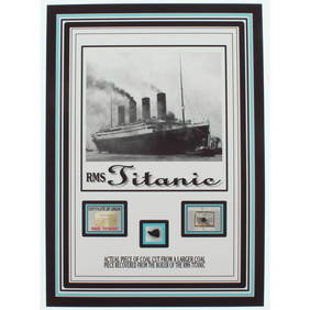
Authentic Coal From Titanic Wreckage on 6x8 Photo (The Zone COA)Activity Auctions4.5(354)See Sold PriceFeb 27, 2024
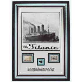
Authentic Coal From Titanic Wreckage on 6x8 Photo (The Zone COA)Activity Auctions4.5(354)See Sold PriceFeb 27, 2024
ISLAMIC FATIMID AL AZIZ NIZAR SILVER DIRHAM COINSAntique Arena Inc.4.5(852)See Sold PriceJun 15, 2024
ISLAMIC FATIMID AL AZIZ NIZAR SILVER DIRHAM COINSAntique Arena Inc.4.5(852)See Sold PriceJun 15, 2024