ATLAS of ANTIENT GEOGRAPHY by SAMUEL BUTLER 1843John McInnis Auctioneers,LLC4.6(504)See Sold PriceFeb 24, 2024
18TH C. ANTIQUE MAP: FRENCH & INDIAN WAR, FRAMEDThomaston Place Auction Galleries4.4(389)See Sold PriceFeb 24, 2024
Rand McNally Railroad Map Cabinet w/ 21 Railroad MapsRail & Road Auctions4.6(165)See Sold PriceMar 08, 2024
Keith Haring - Ink on New York Map, Best Buddies, Inscribed, Signed, and DatedSapphire Auction Gallery4.1(67)See Sold PriceMar 02, 2024
LATE 17TH C. FRENCH MAP OF THE NEW WORLD BY ALEXIS-HUBERT JAILLOT (1632-1712)Thomaston Place Auction Galleries4.4(389)See Sold PriceFeb 24, 2024
Central Railroad of New Jersey Map of Sandy Hook Route-ca. 1903JM Hobby Supply and Railroad Artifact Auctions4.4(126)See Sold PriceFeb 24, 2024
Lot of Six Mixed Atlas Box Cars-HO Scale-New in BoxJM Hobby Supply and Railroad Artifact Auctions4.4(126)See Sold PriceFeb 25, 2024
Rand McNally/Santa Fe Railroad Map of Iowa-1912JM Hobby Supply and Railroad Artifact Auctions4.4(126)See Sold PriceFeb 24, 2024
NICOLAES VISSCHER (NETHERLANDS, 1618-1709) MAP OF THE NEW WORLDThomaston Place Auction Galleries4.4(389)See Sold PriceFeb 24, 2024
17TH C. WORLD MAP BY NICOLAES VISSCHER (NETHERLANDS, 1618-1709)Thomaston Place Auction Galleries4.4(389)See Sold PriceFeb 24, 2024
Lot of Six Mixed Atlas Cabooses-HO Scale-New in BoxJM Hobby Supply and Railroad Artifact Auctions4.4(126)See Sold PriceFeb 25, 2024
SoldBradford: Map of Hindostan, 1835Hindostan, T. G. Bradford, 1835 7.75 x 10. Antique hand colored map of Hindostan (India) including New Delhi and Ceylon (Sri Lanka). With hand colored border detailing. Very good condition. By T.G. BrSee Sold Price
Sold1835 Bradford Map of India and Sri Lanka -- HindostanReserve Reduced! Title/Content of Map: 1835 Bradford Map of India and Sri Lanka -- Hindostan Date: 1835, London Cartographer: T Bradford Size: 9.8 x 7.8 in. This is a very nice map of India and CeylonSee Sold Price
1835 Bradford Map of India and Sri Lanka -- HindostanTitle/Content of Map: 1835 Bradford Map of India and Sri Lanka -- Hindostan Date: 1835, London Cartographer: T Bradford Size: 9.8 x 7.8 in. This is a very nice map of India and Ceylon (Sri Lanka). TheSee Sold Price
1835 Bradford Map of India and Sri Lanka -- HindostanTitle/Content of Map: 1835 Bradford Map of India and Sri Lanka -- Hindostan Date: 1835, London Cartographer: T Bradford Size: 9.8 x 7.8 in. This is a very nice map of India and Ceylon (Sri Lanka). TheSee Sold Price
SoldBradford: Map of Florida, 1835Map: Florida Cartographer: Thomas G. Bradford Illustrator: Thomas G. Bradford Edition: First Edition Publisher: Thomas G. Bradford Date: 1835 Size: 7.75 x 10.25 inches Beautiful, hand colored first edSee Sold Price
1835 Bradford map of Pennsylvania and New JerseyItem: 1835 Bradford map of Pennsylvania and New Jersey Description: This rare map of Pennsylvania & New Jersey was printed in 1835 by the important American mapmaker Bradford. Originally published inSee Sold Price
Sold1835 Bradford Map of British IslandsClean hand-colored 1835 map of the British Islands by the important American mapmaker T. G. Bradford. It includes England, Scotland, Wales and Ireland and covers from the southern tip of the ShetlandSee Sold Price
SoldBradford: Map of Turkey, 18351835 Bradford map of Turkey. 7.75 x 10. This unusual map by Thomas Gamaliel Bradford depicts the Asian portions of Turkey, the Black Sea, the Caucuses (Georgia, Azerbaijan, and Armenia), and what is tSee Sold Price
Sold1835 Bradford Map of the British Islands -- BritishTitle/Content of Map: 1835 Bradford Map of the British Islands -- British Islands Date: 1835, London Cartographer: T Bradford Size: 10 X 7.8 in. This is a nice detailed map of the British Islands, andSee Sold Price
1835 Bradford map Penn/N JerseyRare map of Pennsylvania and New Jersey published 1835 by the important American mapmaker Thomas G. Bradford. From Bradford's 1835 atlas. Outline hand color by county. Light hint of a transfer from anSee Sold Price
SoldThomas G. Bradford Map of Egypt - 1835**First Time At Auction** Thomas G. Bradford (American). Map of Egypt, ca. 1835. A map of Egypt by American mapmaker Thomas G. Bradford, published as plate no. 108 in Bradford's "Comprehensive Atlas GSee Sold Price
Sold4 TN Maps, Bradford, 1835, 1838, & 18411st item: "Tennessee" Map, by Thomas G. Bradford, engraved by George W. Boynton, published by William D. Ticknor, Boston, 1835. From "A Comprehensive Atlas, Geographical, Historical & Commercial" by TSee Sold Price
SoldBRADFORD. Map of Texas. 1835First Separate Map of Texas to Appear in an Atlas 84. [MAP]. [BRADFORD, Thomas Gamaliel]. Texas [left margin outside neat line] 64.A. [Boston & New York, 1835]. Engraved map, original outline coloSee Sold Price
1835 Bradford Map of the British Islands -- BritishTitle/Content of Map: 1835 Bradford Map of the British Islands -- British Islands Date: 1835, London Cartographer: T Bradford Size: 10 X 7.8 in. This is a nice detailed map of the British Islands, andSee Sold Price
Sold1835 Bradford Map of Massachusetts1835 Bradford map of Massachusetts. Covers the entire state as well as parts of the neighboring states of Connecticut, Vermont and New Hampshire. Martha's Vineyard (Dukes Island) and Nantucket IslandSee Sold Price
1835 Bradford Map of Colombia, Venezuela, Ecuador andBRADFORD, T. G (1802-1887). Colombia & Guiana. Engraved Map from Comprehensive Atlas Geographical, Historical and Commerical. Boston, C. 1835. 10 1/4" x 12 3/4" sheet.See Sold Price
1835 Bradford Map of Kentucky and Tennessee1835 Bradford Map of Kentucky and Tennessee -- Tennessee & Kentucky T Bradford 1835, Boston / New York 7.9 X 10 in. Nice and scarce early map of these great states, swing their counties, towns, canalsSee Sold Price
1835 Bradford map of Northern AsiaOriginal outline hand coloring of northern Asia. Interesting copperplate map shows all of Russia and northern countries, plus major portion of China and eastern Europe. From Thomas Gamaliel Bradford��See Sold Price
1835 Bradford map of Northern AfricaOriginal outline hand coloring of northern Africa. Interesting copperplate map shows nice detail of coastlines of the Atlantic, Mediterranean and Red Sea, islands, waterways, mountains and cities. FroSee Sold Price
1835 Bradford map Penn/N JerseyRare map of Pennsylvania and New Jersey published 1835 by the important American mapmaker Bradford. From Bradford's 1835 atlas. Outline hand color by county. Light hint of a transfer from another map.See Sold Price
Scarce 1835 Bradford map of Illinois/Missouri.Reserve Reduced! One of the earliest maps engraved in America to focus on this region. Scarce early map of Missouri & Illinois, also showing Arkansaw Territory to the South and Missouri Territory to tSee Sold Price
1835 Bradford map of Northern AfricaOriginal outline hand coloring of northern Africa. Interesting copperplate map shows nice detail of coastlines of the Atlantic, Mediterranean and Red Sea, islands, waterways, mountains and cities. FroSee Sold Price
1835 Bradford map of Northern AsiaOriginal outline hand coloring of northern Asia. Interesting copperplate map shows all of Russia and northern countries, plus major portion of China and eastern Europe. From Thomas Gamaliel Bradford��See Sold Price
1835 Bradford Map of the British Islands -- BritishReserve Reduced! Title/Content of Map: 1835 Bradford Map of the British Islands -- British Islands Date: 1835, London Cartographer: T Bradford Size: 10 X 7.8 in. This is a nice detailed map of the BriSee Sold Price
Central Railroad of New Jersey Map of Sandy Hook Route-ca. 1903JM Hobby Supply and Railroad Artifact Auctions4.4(126)See Sold PriceFeb 24, 2024
Rand McNally/Santa Fe Railroad Map of Iowa-1912JM Hobby Supply and Railroad Artifact Auctions4.4(126)See Sold PriceFeb 24, 2024
17TH C. WORLD MAP BY NICOLAES VISSCHER (NETHERLANDS, 1618-1709)Thomaston Place Auction Galleries4.4(389)See Sold PriceFeb 24, 2024
LATE 17TH C. FRENCH MAP OF THE NEW WORLD BY ALEXIS-HUBERT JAILLOT (1632-1712)Thomaston Place Auction Galleries4.4(389)See Sold PriceFeb 24, 2024
18TH C. ANTIQUE MAP: FRENCH & INDIAN WAR, FRAMEDThomaston Place Auction Galleries4.4(389)See Sold PriceFeb 24, 2024
NICOLAES VISSCHER (NETHERLANDS, 1618-1709) MAP OF THE NEW WORLDThomaston Place Auction Galleries4.4(389)See Sold PriceFeb 24, 2024
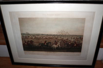
HENRY ALKEN / LEWIS Original 1835 Hand Colored Engraving Quorn Hunt DrawingLuis Porretta Fine Arts4.3(10)See Sold PriceMar 02, 2024
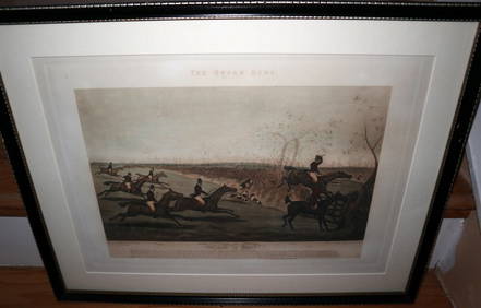
HENRY ALKEN / LEWIS Original 1835 Hand Colored Engraving Quron Hunt Snob Is BeatLuis Porretta Fine Arts4.3(10)See Sold PriceMar 02, 2024
Numismatic Books - Lelewel - Numismatique du Moyen-AgeTimeLine Auctions Ltd.4.6(182)See Sold PriceMar 09, 2024
Group of Ten Railroad Photographs, Maps, and Prints - New Jersey, Long Island, and New YorkRail & Road Auctions4.6(165)See Sold PriceMar 07, 2024
Keith Haring - Ink on New York Map, Best Buddies, Inscribed, Signed, and DatedSapphire Auction Gallery4.1(67)See Sold PriceMar 02, 2024
Rand McNally Railroad Map Cabinet w/ 21 Railroad MapsRail & Road Auctions4.6(165)See Sold PriceMar 08, 2024
[TWAIN, Mark (pseudonym of CLEMENS, Samuel Langhorne, 1835-...Potter & Potter Auctions4.6(544)See Sold PriceMar 07, 2024
American Flyer Lionel Std Ga parts trim 1835 4615 MoreElliott Auctions4.6(128)See Sold PriceFeb 24, 2024
Putnam - First Map of the State of Ohio by Rufus PutnamTrillium Antique Prints & Rare Books4.5(30)See Sold PriceFeb 24, 2024
Gould - Natterer's Aracari or ToucanTrillium Antique Prints & Rare Books4.5(30)See Sold PriceFeb 24, 2024
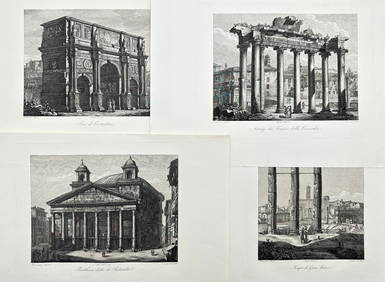
Domenico Amici - Set of 4 prints - Tempio di Giove Statore - Arco di Costantino in Rome, ItalyProverde Auctions4.3(3)See Sold PriceFeb 28, 2024