SoldBowles and Carver. Map of MiddlesexBowles and Carver. Publishers. New Medium Map of Middlesex,engraved map with original hand-colouring, 225 x 325mm., [c.1800] Darton (William & Son) Middlesex, with vignette view of BlackfriaSee Sold Price
SoldExhibited 18th C Bowles & Carver Map - Spain & Portugal**Originally Listed At $50** Bowles and Carver - Carington II Bowles ; Henry Carington Bowles; Samuel Carver (British, active 1793-1832), "Bowles's New One-Sheet Map of the Kingdoms of Spain and PortuSee Sold Price
Exhibited 18th C Bowles & Carver Map - Spain & PortugalBowles and Carver - Carington II Bowles ; Henry Carington Bowles; Samuel Carver (British, active 1793-1832), "Bowles's New One-Sheet Map of the Kingdoms of Spain and Portugal, according to De Lifle: WSee Sold Price
SoldENGLISH COLORED MAP publisher- Bowles & Carver sENGLISH COLORED MAP publisher- Bowles & Carver sight- 10 1/4" x 15 3/4"See Sold Price
SoldBowles & Carver. Bowles's New One-Sheet Map of IreBowles & Carver. Bowles's New One-Sheet Map of Ireland, Divided into its Provinces, Counties & Baronies,engraved map with full original hand-colouring, oval title cartouche at upper left, 635See Sold Price
Sold1753 Bowles & Carver Birds' Eye View of London -- VueReserve Reduced! Title/Content of Map: 1753 Bowles & Carver Birds' Eye View of London -- Vue Generale de la Ville de Londres Date: 1753 Cartographer: Bowles & Carter Size: 8.9 X 15.1 in. An attractiveSee Sold Price
SoldMap of Jamaica c.1780Title: Bowles's New One-Sheet Map of Jamaica Divided into it's Parishes, &c., from the Actual Surveys of Sheffield and others Author: Bowles & Carver Description: Copper-engraved map, hand-colored. 4See Sold Price
SoldBowles's New Pocket Map of England & Wales with theBowles's New Pocket Map of England & Wales with the Addition of New Roads and other Improvements by Daniel Paterson Esq., published Bowles & Carver, circa 1780, engraved map with contemporary hand colSee Sold Price
SoldBOWLES and CARVER. Bowles's New One-Sheet MapBOWLES and CARVER. Bowles's New One-Sheet Map of America. Engraved folding map of North and South America, 600x600 mm, wide margins; hand-colored. London: Bowles & Carver, circa 1796 All items are ofSee Sold Price
Sold(Maps and Charts, North America), Bowles & Carver,(Maps and Charts, North America), Bowles & Carver, Bowles's New One Sheet Map of New England: Comprehending the Provinces of Massachusetts Bay and New Hampshire: with the Colonies of Connecticut & RhoSee Sold Price
BOWLES, John. Bowles's New Pocket Map of the DiscoBOWLES, John. Bowles's New Pocket Map of the Discoveries of the Russians on the West Coast of North America.London: Bowles & Carver, [c.1795]. Double-page engraved map, hand-colored in outlinSee Sold Price
SoldCarington Bowles. New One-Sheet Map of the Seven UnitedCarington Bowles. New One-Sheet Map of the Seven United Provinces or Holland, folding hand coloured map, by J. Palairet, for Bowles & Carver, 48 x 62cm, with wallet; and a folding plan of the port ofSee Sold Price
SoldEARLY ENGLISH MAP OF LONDONEARLY ENGLISH MAP OF LONDON hand-colored, "Bowles's New Two-Sheet Plan of the Cities of London & Westminster; with the Borough of Southwick", 1797, printed for Bowles & Carver, London, title to upperSee Sold Price
SoldBowles & Carver. Publishers. - Bowles's New Four-sheetrare wall map with large title cartouche supported by explorers, upper left, 4 compass roses, latitudinary and longitudinary scales below, engraved map by B. Baker, with original hand-colouring, on foSee Sold Price
SoldLondon.- Bowles & Carver Bowles's One-Sheet Plan of theLondon.- Bowles & Carver Bowles's One-Sheet Plan of the Cities of London and Westminster, with the Borough of Southwark, comprehending their outskirts and extent of the Thames from Chelsea to DeptfordSee Sold Price
SoldLondon.- Bowles & Carver (publishers) & RobertLondon.- Bowles & Carver (publishers) & Robert Wilkinson. A View of Westminster Bridge from Lambeth; A View of the City of London..., a pair of London views, the first mentioned by Pierre Charles CanoSee Sold Price
SoldLondon.- Bowles & Carver. Bowles's Two-Sheet Plan ofLondon.- Bowles & Carver. Bowles's Two-Sheet Plan of the Cities of London and Westminster with the Borough of Southwark; Comprehending the New Buildings and other Alterations, showing part of Hyde ParSee Sold Price
Bowles & Carver. 10 engravings on Robinson Crusoe.AA.VV. Bowles & Carver. 10 incisioni riguardanti le avventure di Robinson Crusoe. 1783 Ottime condizioni. 175x262 mm.See Sold Price
Bowles & Carver - Coloured engraving - "Bowles NewBowles & Carver - Coloured engraving - "Bowles New Topographical Chart of the English Channel with Its Environs", 19.5ins x 27.5ins, and two further maps, all framed and glazedSee Sold Price
SoldBowles, France, English Channel (2) HC EngravingsTitle: Map of France Divided Into 83 Departments According to the Decree of the National Assembly & English Channel with Its Environs - two, Pub: Bowles & Carver, Date: C.1800, Medium: Copperplate engSee Sold Price
SoldBOWLES, FRANCE, ENGLISH CHAN.- (2) HC ENGR,1800Title: Map of France Divided Into 83 Departments According to the Decree of the National Assembly & English Channel with Its Environs - two, Pub: Bowles & Carver, Date: C.1800, Medium: Copperplate engSee Sold Price
Sold19th Century English Print19th century English print titled: "Direct Roads - To Bath by Devices, To Bristol by Mansfield" Published by Bowles and Carver, London, printed 1785, Provenance the 'The Antique Map Shop Ltd., Bath EnSee Sold Price
SoldR. W. Seale,R. W. Seale, Map of the County of Middlesex, hand coloured engraving c.1760, for Bowles and Sayer, 53 x 73cm (visible)See Sold Price
Warburton (John) The Counties of Essex Middlesex &Warburton (John) The Counties of Essex Middlesex & Hertfordshire,Pirate edition of Warburton's map by Philip Overton and Thomas Bowles, inset prospect of Colchester, and inset plan of St. AlbaSee Sold Price
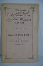
Boston and Maine RR Annual Report-September 12, 1849JM Hobby Supply and Railroad Artifact Auctions4.4(127)See Sold PriceFeb 24, 2024
1892 Adams and Bowles New Road Map of the State of New YorkJM Hobby Supply and Railroad Artifact Auctions4.4(127)See Sold PriceFeb 24, 2024
Central Railroad of New Jersey Map of Sandy Hook Route-ca. 1903JM Hobby Supply and Railroad Artifact Auctions4.4(127)See Sold PriceFeb 24, 2024
Cincinnati Hamilton and Dayton RR Map -USGC 1889JM Hobby Supply and Railroad Artifact Auctions4.4(127)See Sold PriceFeb 24, 2024
Rand McNally/Santa Fe Railroad Map of Iowa-1912JM Hobby Supply and Railroad Artifact Auctions4.4(127)See Sold PriceFeb 24, 2024
17TH C. WORLD MAP BY NICOLAES VISSCHER (NETHERLANDS, 1618-1709)Thomaston Place Auction Galleries4.4(393)See Sold PriceFeb 24, 2024
LATE 17TH C. FRENCH MAP OF THE NEW WORLD BY ALEXIS-HUBERT JAILLOT (1632-1712)Thomaston Place Auction Galleries4.4(393)See Sold PriceFeb 24, 2024
18TH C. ANTIQUE MAP: FRENCH & INDIAN WAR, FRAMEDThomaston Place Auction Galleries4.4(393)See Sold PriceFeb 24, 2024
NICOLAES VISSCHER (NETHERLANDS, 1618-1709) MAP OF THE NEW WORLDThomaston Place Auction Galleries4.4(393)See Sold PriceFeb 24, 2024
OGILVY & BOWEN c1736 Original Map of Oxfordshire Berkshire Etc.Luis Porretta Fine Arts4.3(10)See Sold PriceMar 02, 2024
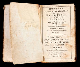
BOWLES'S UNIVERSAL DISPLAY of NAVAL FLAGS c1790John McInnis Auctioneers,LLC4.5(505)See Sold PriceFeb 24, 2024
Nova Totius Full Color Geographical World MapThe Benefit Shop Foundation Inc.4.3(2.9k)See Sold PriceFeb 28, 2024
Keith Haring - Ink on New York Map, Best Buddies, Inscribed, Signed, and DatedSapphire Auction Gallery4.1(67)See Sold PriceMar 02, 2024
Rand McNally Railroad Map Cabinet w/ 21 Railroad MapsRail & Road Auctions4.6(165)See Sold PriceMar 08, 2024
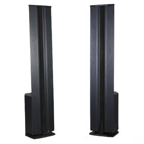
Carver AL-III Plus High End Stereo Audio SpeakersHill Auction Gallery 4.7(1k)See Sold PriceFeb 28, 2024
Willem Blaeu, Etc. 17th C. Antiquarian Maps, 2Auctions at Showplace4.6(740)See Sold PriceMar 17, 2024
Putnam - First Map of the State of Ohio by Rufus PutnamTrillium Antique Prints & Rare Books4.5(32)See Sold PriceFeb 24, 2024