Boundary between Alaska & Canada 1886 with mapsHeading: Author: [Cleveland, Grover] Title: Message from the President of the United States transmitting a report of the Secretary of State relative to the frontier line between Alaska and British CoSee Sold Price
SoldAtlas of U.S./Canada Alaska boundary 1918Title: Joint maps of the international boundary between the United States and Canada along the 141st meridian from the Arctic Ocean to Mount St. Elias. 38 sheets. Surveyed and monumented 1907-1913 undSee Sold Price
SoldVintage Alaska and West Canada MapBeautiful five-color lithographic map with index, produced by Knoll Map Company, Seattle. Included is the original jacket attached to the back. Very good condition, great color. Mounted and wrapped.,,See Sold Price
Sold1855 Colton Map of Canada, Alaska and Greenland --Title/Content of Map: 1855 Colton Map of Canada, Alaska and Greenland -- Northern America - British, Russian and Danish Possessions in North America Date: 1855, New York Cartographer: J Colton Size: 1See Sold Price
SoldColton: Antique Map Canada, Russian Alaska & GreenlandTitle/Content of Map: Canada, Russian Alaska & Greenland Date Printed: 1859 Cartographer: H.J. Colton Material/Medium: Paper Size: 17 1/2" x 15" Hand colored, engraved Map. Published in New York in CoSee Sold Price
White: Map of Canada Alaska Greenland Aboriginals, 1906Title/Content of Map: 'Aborigines of Canada, Alaska and Greenland' Eskimo Athapascan Tlinkit Salish &c. Date Printed: 1906 Image Size: Approx 40.5 x 56.0cm, 15.75 x 22 inches (Large); Please note thatSee Sold Price
1886 Map of AlaskaAuthor: Watson Title: 1886 Map of Alaska Medium: Ink on Paper Dimensions: 14.5"X11" Map of Alaska dated 1886. Printed and published by Watson in Chicago. Part of his World Atlas. Key lower left. ColorSee Sold Price
MAP, Western Canada & Alaska, La PerouseWestern Canada & Alaska. Jean Francois Galoup, Comte La Perouse, Carte Particuliere de la Cote du Nord-Ouest de l'Amerique Reconnue par les Fregates Francaises la Boussole et l'Astrolabe en 1786. 1e.See Sold Price
1886 Map of CanadaAuthor: Blackie Title: 1886 Map of Canada Medium: Ink on Paper Dimensions: 21"X15" Map of Canada dated 1886. Part of the Imperial Atlas of Modern Geography. This was the revised edition under the supeSee Sold Price
1886 Map of AlaskaAuthor: Watson Title: 1886 Map of Alaska Medium: Ink on Paper Dimensions: 13.5"X11" Map of Alaska dated 1887. Printed and published by Watson in Chicago. Part of his World Atlas. Key lower right. WithSee Sold Price
SoldAlaska and Western Canada Kroll Map34 1/8" by 42 3/4" Allard Auction Collection Inv: AXSee Sold Price
1886 Map of AlaskaAuthor: Watson Title: 1886 Map of Alaska Medium: Ink on Paper Dimensions: 14.5"X11" Map of Alaska dated 1886. Printed and published by Watson in Chicago. Part of his World Atlas. Key lower left. ColorSee Sold Price
1886 Map of AlaskaAuthor: Cram Title: 1886 Map of Alaska Medium: Ink on Paper Dimensions: 14.5"X11" Map of Alaska dated 1886. Printed and published by Watson in Chicago. Part of his World Atlas. Key lower left. Color cSee Sold Price
1886 - Alaska State Map1886 - Alaska State Map **|**|** This is a beautiful, 129 year old map of Alaska - published in the USA by Rand McNally. The map is on much thicker paper than most maps of the same era - it is similarSee Sold Price
Bellin: Antique Map Northern Canada, Early Alaska, 1760Map: Carte Reduite des Parties Septentrionales du Globe, Situees entre l'Asie et l'Amerique Cartographer: Bellin Place & Date: Paris / 1760 Size: 13 5/8" x 8 1/4" Condition: b&w; light overall age tonSee Sold Price
Sold1850 Tallis Map of Canada -- British AmericaReserve Reduced! Title/Content of Map: 1850 Tallis Map of Canada -- British America Date: 1850, London Cartographer: J Tallis Size: 10 x 13 in. A very nice map of Canada plus Alaska, aka Russian AmeriSee Sold Price
British Case Alaska Boundary Commission Appendix.[America/ Alaska] 18 sheets of maps, 2 index maps. Great Britain/Alaska Boundary Tribunal. “British case, Alaska boundary. Appendix Vol. III. -- : portfolio of maps accompanying International BoSee Sold Price
SoldLedger Art Assemblage, Northwest Coast, NorwegianFramed contemporary Ledger Art assemblage, Pacific Northwest Coast. The assemblage depicts an antique note card: Neah Bay, 1879, over a vintage Norwegian map of Alaska and Canada. Housed under plexiglSee Sold Price
SoldBoundary dispute between U.S. and Canada 1873 with mapsHeading: Author: Great Britain Title: North America. No. 3 [-9] (1873). (A.[-G.]) North-West American Water Boundary... Presented to both Houses of Parliament by Command of Her Majesty Place PublisheSee Sold Price
Sold1759 Voyages Geography MAPS Native American Indians1759 Voyages Geography MAPS Native American Indians Asia Alaska Canada Prevost The ‘General History of Voyages’ by abbe Prevost is one of the largest and most impressive collections of stories ofSee Sold Price
SoldAlaska Boundary Tribunal Atlas of Award, 1904,Original government binding of the Alaska Boundary Tribunal with 25 sectional maps and index showing the line fixed by the Tribunal, 1904, Government Printing Office. 16 x 19". Title page and fly pageSee Sold Price
Joint Maps of the International Boundary BetweenAuthor: ** Description: 42 maps sheets, most in color. 27¾x18¼, cloth. Detailed and precisely surveyed strip maps of the boundary between Alaska and the Yukon Territory. Heading: (Alaska Boundary) PSee Sold Price
Sold1897 1ed Alaska & Klondike Gold Mining Fields Canada Eskimo INDIANS Slavery MAP1897 1ed Alaska & Klondike Gold Mining Fields Canada Eskimo INDIANS Slavery MAP AC Harriss “Alaska and the Klondike Gold Fields” is a 19th-century account of expeditions in Canada and AlasSee Sold Price
SoldWildlife,Hunting,Fishing & Exploration ALASKA & CANADACollection of thirteen first edition hardcover books. 1) HUNTING in the UPPER YUKON, Thomas Martindale, 1913 (illustrated from photographs, plates, map). 2) Northern Trails, William J. Long, 1905. 3)See Sold Price
Map UNITED COUNTIES LEEDS & GRENVILLE by Walling 1861 Rare Canada Map 5ft x 5ftLuis Porretta Fine Arts4.3(10)See Sold PriceMar 02, 2024
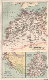
MOROCCO LIBERIA & MAURITIUS. Sierra Leone. BARTHOLOMEW 1886 old antique mapJasper524.5(9.9k)See Sold PriceFeb 28, 2024
NILE VALLEY. Upper & Lower. Egypt Sinai Nubia Sudan Abyssinia. BLACKIE 1886 mapJasper524.5(9.9k)See Sold PriceFeb 28, 2024
Central Africa. Congo Zambia Tanzania Kenya Mozambique. BARTHOLOMEW 1886 mapJasper524.5(9.9k)See Sold PriceFeb 28, 2024
MAGHREB. North Africa. Marocco Algeria and Tunis. BLACKIE 1886 old antique mapJasper524.5(9.9k)See Sold PriceFeb 28, 2024
EARLY COLONIAL WEST AFRICA. Empires of Sokoto Gando Mas.Tribes.Fellatah 1886 mapJasper524.5(9.9k)See Sold PriceFeb 28, 2024
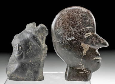
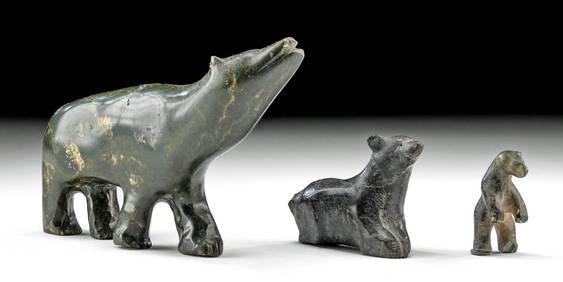
Alaskan / Canadian Inuit Stone Bird + Reclining SealArtemis Fine Arts4.8(1.4k)See Sold PriceFeb 26, 2024
Inuit Soapstone Carvings Face Profile + Abstract FacesArtemis Fine Arts4.8(1.4k)See Sold PriceFeb 26, 2024
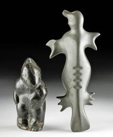
Inuit Soapstone Sculpture - Conjoined Male & FemaleArtemis Fine Arts4.8(1.4k)See Sold PriceFeb 26, 2024
Robert de Vaugondy - Map of Canada - Mer de l' Ouest or Sea of the West and a Northwest PassageProverde Auctions4.3(3)See Sold PriceFeb 28, 2024
Mostly U.S., Some Canada Maps etc (40 Pcs)Grant Zahajko Auctions, LLC4.7(1k)See Sold PriceMar 06, 2024