SoldBonne map of China, Korea & Japan c.1780Title: Empire de la Chine, Rme de Corée et Isles du Japon Author: Bonne, Rigobert Description: Copper-engraved map, hand-colored (later). 23.5x34.5 cm. (9¼x13½"); hinged to mat, framed under plexigSee Sold Price
SoldFRENCH BONNE MAP OF CHINA, KOREA & JAPAN, 18TH C.Framed engraving with hand coloring on paper, map of China, Korea, and Japan, "Empire De La Chine, Rme De Coree et Isles Du Japon," Rigobert Bonne (French, 1727-1794) cartographer, engraved by PietroSee Sold Price
SoldBonne: Antique Map of Tartary China Korea Japan, 1787Item: Map of Tartary China Korea Japan 1787 Bonne Etching On Copper Very beautiful map of Tartary, China, Korea and Japan Author: Bonne Rigobert (1727-1794) Atlas: Atlas de toutes parties connues du gSee Sold Price
Bonne: Antique Map of Tartary China Korea Japan, 1787Item: Map of Tartary China Korea Japan 1787 Bonne Etching On Copper Very beautiful map of Tartary, China, Korea and Japan Author: Bonne Rigobert (1727-1794) Atlas: Atlas de toutes parties connues du gSee Sold Price
Tartarie Chinoise, Royaume de Corée &… Japon. China Korea Japan. BONNE 1788 mapTITLE/CONTENT OF MAP: Tartarie Chinoise, Royaume de Corée et Isles du Japon [Chinese Tartary, The Kingdom of Korea and the islands of Japan] DATE PRINTED: 1788 IMAGE SIZE: Approx 24.5 x 36.5cm, 9See Sold Price
Tartarie Chinoise, Royaume de Corée &… Japon. China Korea Japan. BONNE 1790 mapTITLE/CONTENT OF MAP: Tartarie Chinoise, Royaume de Corée et Isles du Japon [Chinese Tartary, The Kingdom of Korea and the islands of Japan] DATE PRINTED: 1790 IMAGE SIZE: Approx 24.5 x 36.5cm, 9See Sold Price
Tartarie Chinoise, Royaume de Corée &… Japon. China Korea Japan. BONNE 1790 mapTITLE/CONTENT OF MAP: Tartarie Chinoise, Royaume de Corée et Isles du Japon [Chinese Tartary, The Kingdom of Korea and the islands of Japan] DATE PRINTED: 1790 IMAGE SIZE: Approx 24.5 x 36.5cm, 9See Sold Price
Tartarie Chinoise, Royaume de Corée &… Japon. China Korea Japan. BONNE 1788 mapTITLE/CONTENT OF MAP: Tartarie Chinoise, Royaume de Corée et Isles du Japon [Chinese Tartary, The Kingdom of Korea and the islands of Japan] DATE PRINTED: 1788 IMAGE SIZE: Approx 24.5 x 36.5cm, 9See Sold Price
SoldMAP, China, Korea & Japan, Bonne/LattreChina, Korea & Japan. Bonne/Lattre, L'Empire de la Chine d'Apres l'Atlas Chinois, avec les Isles du Japon, from Atlas Moderne, 1787 (circa). Hand Color. Beautifully engraved, decorative map of the ChiSee Sold Price
China.- Bonne (Rigobert) L'Empire de la ChineChina.- Bonne (Rigobert) L'Empire de la Chine d'après lAtlas Chinois, avec les Isles du Japon, decorative map of the Chinese Empire, extending to include Taiwan, Hainan, Korea, and Japan, with deSee Sold Price
Korea centered map with Japan and eastern coast of China. 1790 by BonneTitle: Korea centered map with Japan and eastern coast of China. 1790 by Bonne Date/Period: 1790 Materials: Copper plate engraved Size: 14 3/4” x 10 3/4” 1780-1790, published 1790 in "AtlaSee Sold Price
SoldMAP, China, Korea & Japan, Mercator/HondiusHondius' Map of China, Korea, and Japan in Full Contemporary Color. China, Korea & Japan. Mercator/Hondius, China, from Gerardi Mercatoris - Atlas sive Cosmographicae, 1613 (circa). Hand Color. BesideSee Sold Price
SoldMAP, China, Korea & Japan, CluverChina, Korea & Japan. Philipp Cluver, Imperii Sinarum Nova Descriptio, from Introductio in Universam Geographicam, 1697 (published). Hand Color. Handsome small map based on the important Martini/BlaeuSee Sold Price
MAP, China, Korea & Japan, BellinChina, Korea & Japan. Jacques Nicolas Bellin, Carte des Isles du Japon et la Presqu Isle de Coree avec les Costes de la Chine Depuis Pekin Jusqua Canton, from Prevost's Histoire Generale des Voyages��See Sold Price
MAP, China, Korea & Japan, MercatorChina, Korea & Japan. Mercator/Jansson, China, 1630 (published). Hand Color. This handsome map of the region is based on the folio map by Jodocus Hondius and was designed for the Atlas Minor, first puSee Sold Price
Map China Korea Japan 1875 coloured PetermannCHINA KOREA UND JAPAN Beatiful map of China Korea and Japan of 1875 circa coloured by hand with aquarello painting. Author: Von A. Petermann Date: 1875 circa Technique: Copper etching Leaf Dimension:See Sold Price
MAP - China, Korea & Japan. MercatorChina, Korea & Japan. Mercator/Hondius, China, 1619 (published). Hand Color. Besides China, this map depicts Korea as an elongated island and Japan on the Ortelius-Teixeira model. The map contains rudSee Sold Price
MAP, China, Korea & Japan, JanssonChina, Korea & Japan. Jan Jansson, China Veteribus Sinarum Regio nunc Incolis Tame Dicta, 1647 (published). Hand Color. Several large lakes dominate the topography of this elegantly engraved map of ChSee Sold Price
MAP, China, Korea & Japan, De RossiChina, Korea & Japan. Cantelli da Vignola/de Rossi, Il Regno della China detto Presentemente Catay, e Mangin. Diviso Sopra le Carte piu Esatte nelle sue Principali Provincie..., 1682 (dated). Hand ColSee Sold Price
MAP - China, Korea & Japan. CluverChina, Korea & Japan. Philipp Cluver, Imperii Sinarum Nova Descriptio, 1711 (published). Hand Color. Handsome small map based on the important Martini/Blaeu map of the Chinese Empire. It shows a fairSee Sold Price
Original Antique Map - China - Korea - Japan - 19th Century - East Asia - LapieA fine first edition example of M. Lapie's 1832 map of the Chinese empire and Japan. The map covers all of China, Korea, and Japan from Asiatic Russia to India and the Sea of China and from IndependenSee Sold Price
MAP, China, Korea & Japan, CluverChina, Korea & Japan. Philipp Cluver, Imperii Sinarum Nova Descriptio, 1667 (circa). Black & White. Handsome small map based on the important Martini/Blaeu map of the Chinese Empire. It shows a fair nSee Sold Price
MAP - China, Korea & Japan. JanssonChina, Korea & Japan. Jan Jansson, China Veteribus Sinarum Regio nunc Incolis Tame Dicta, 1647 (published). Hand Color. Several large lakes dominate the topography of this elegantly engraved map of ChSee Sold Price
MAP - China, Korea & Japan. CluverChina, Korea & Japan. Philipp Cluver, Imperii Sinarum Nova Descriptio, 1667 (circa). Black & White. Handsome small map based on the important Martini/Blaeu map of the Chinese Empire. It shows a fair nSee Sold Price
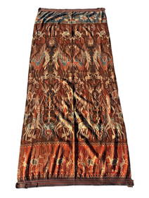
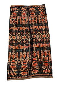
A Fine RARE Antique Woven ikat Pictorial TextilePremier Auction Galleries4.3(329)See Sold PriceMar 09, 2024
Pair of Alpine Black Swallowtail in Framed Showing Its Spring and Summer FormWeatherham Estate Treasures3.9(157)See Sold PriceFeb 29, 2024
Famous Dealer Spink 1997 Form & Function Furniture from China Japan and KoreaSunburst Auction4.4(21)See Sold PriceFeb 24, 2024
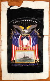
(Early 20th c) MEMENTO of the U.S.S. MONTANAJohn McInnis Auctioneers,LLC4.6(504)See Sold PriceFeb 25, 2024
Perry, Matthew C. 1856 Large Map. Shah Bay, Lew Chew I. JapanAlbion Auctions4.6(341)See Sold PriceMar 01, 2024
ANTIQUE ILLUSTRATED HANDBOOK OF GEOGRAPHY AND TRAVEL IN ASIA, VOLUME 2, 1896NY Elizabeth 4.3(85)See Sold PriceMar 03, 2024
Henri Plon - Set of 20 topographical prints depicting Asia - Japan - China - Religious building -Proverde Auctions4.3(3)See Sold PriceFeb 28, 2024