Gothic Revival Stained Glass Window of The ResurrectionSchmidt's Antiques Inc. Since 19114.8(431)See Sold PriceMar 02, 2024
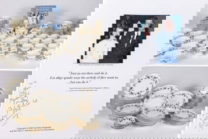
THE FITZGERALD FAMILY TEA and DINNER SERVICEJohn McInnis Auctioneers,LLC4.5(505)See Sold PriceFeb 25, 2024
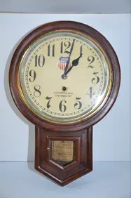
Union Pacific RR Cheyenne, WY Locomotive Shop ClockJM Hobby Supply and Railroad Artifact Auctions4.4(127)See Sold PriceFeb 24, 2024
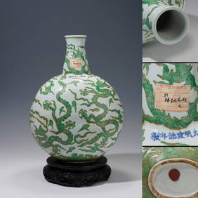
A CHINESE PORCELAIN GREEN ENAMELED DRAGON MOON FLASK BIANHUBerkeley Auction Gallery4.4(16)See Sold PriceMar 03, 2024
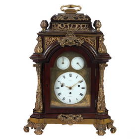
Antique George III Musical Bracket Clock by Hare LondonHill Auction Gallery 4.7(1k)See Sold PriceFeb 28, 2024
No Reserve Early 20th century French / Flemish Design Tapestry 6 ft 2 in x 4 ft 9 in (1.87 m x 1.44Nazmiyal Auctions4.4(34)See Sold PriceFeb 25, 2024
Central Anatolia Konya Antique Rug 4 ft 8 in x 3 ft 8 in (1.42 m x 1.11 m)Nazmiyal Auctions4.4(34)See Sold PriceFeb 25, 2024
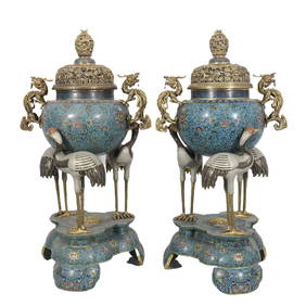
PAIR MAGNIFICENT AND LARGE CLOISONNE ENAMEL CRANES INCENSE BURNERSBerkeley Auction Gallery4.4(16)See Sold PriceMar 03, 2024
From Davide Halevim Collection Antique Persian Mohtashem Kashan Rug 10'11" x 7'10" (3.32 m x 2.38 m)Nazmiyal Auctions4.4(34)See Sold PriceFeb 25, 2024
RARE COVENTRY GLASS WORKS MASONIC FLASKJohn McInnis Auctioneers,LLC4.5(505)See Sold PriceFeb 25, 2024
Empire by Buccellati Italy Sterling Silver Flatware Set 99 pieces DinnerBidhaus4.4(762)See Sold PriceFeb 25, 2024
Blaeu 1647 Map of Near & Middle EastDESCRIPTION: This map, created by Willem Blaeu and Joan Blaeu, features a title cartouche "Turcicum Imperium" showing a Turkish Sultan on his throne, flanked by armed allegorical figures. Also includeSee Sold Price
SoldStoopendaal 1729 Map of Near & Middle EastDESCRIPTION: "De Gelegentheyt Paradys en't Landt Canaan, Mitsgaders d' Eerst Bewoonde Landen der Patriarchen." This Dutch Bible map features region between the Mediterranean and the Persian Gulf. InclSee Sold Price
SoldVarious. 16 maps of the Middle East. 17-19th cent.[Near/ Middle East] 16 maps. Various maps of the Near and Middle East, mostly 19th century. (1) [After Ptolemy] “Tabula Asiae V.” c. 17th century. Weller, Edward. (2) “The Isthmus ofSee Sold Price
Sold3 Middle & Near East Maps, plus Text Sheet & Carved Heraldic Wall Plaque, 5 items1st item: DE BESCHRYVING VAN DE REYSEN PAULI, EN VAN DE ANDERE APOSTELEN map, engraved by Daniel Stoopendaal after Bastian Stoopendaal, published by Pieter and Jacob Keur, Amsterdam, ca. 1730. CopperpSee Sold Price
PhilipsTitle/Content of Map: Philips' Regional Wall Map of the Near East and Middle East (Land of the Five Seas) Cartographer: FULLARD, HAROLD Date: c1956 Publisher: GEORGE PHILIP & SON, LTD. Size: 45HeightSee Sold Price
SoldBlaeu map of AsiaCartographer: Blaeu Title: Asia Noviter Delineata Subject: Asia, China, India, Middle East Published: Amsterdam Date: 1670 Description: This carte-…-figures, one of the most well-known seventeenth-cSee Sold Price
Sold[Middle, Near & Far East]. 3 Maps.[Middle, Near & Far East]. 3 Maps. ++ Partie Orientale De La Carte Des Ancienes Monarchies. [c1750]. Double-page engraving, 20 x 25. Fine. Political boundaries in the ancient world with perimeter of eSee Sold Price
SoldEurope.- Roman Empire.- Ortelius (Abraham) RomaniEurope.- Roman Empire.- Ortelius (Abraham) Romani Imperii Imago, map of the Roman Empire centered on the Mediterranean and covering most of Europe, Northern Africa, and the Near and Middle East, withSee Sold Price
SoldEurope.- Roman Empire.- Ortelius (Abraham) RomaniEurope.- Roman Empire.- Ortelius (Abraham) Romani Imperii Imago, map of the Roman Empire centered on the Mediterranean and covering most of Europe, Northern Africa, and the Near and Middle East, withSee Sold Price
Soldde Vaugondy. Etats du Grand-Seigneur. 1753.[Near and Middle East] de Vaugondy, Robert (French, 1688-1766). "Etats du Grand-Seigneur en Asie, Empire de Perse, Pays des Usbecs, Arabie et Egypte." 1753. Copper-engraved map centered on the ArabianSee Sold Price
The Middle East. Cornelius Dankerts. Holland, 1646Armeniae Maioris Nova Discriptio. Map of the Near East. The Israelites' journey in the desert. Abraham's journey from Ur to Nablus. By Cornelius Dankerts. Holland, 1646. Dutch. 47.5x33.6 cm. (54.5x41See Sold Price
SoldMap of Judea, Samaria and the Jordan Valley; map ofMap of Judea, Samaria and the Jordan Valley; map of Tel Aviv, map of Jerusalem; map of the Near East and Asia; map of Egypt; map of Iraq; map of the oil route in the Middle East; map of the Land of IsSee Sold Price
SoldSCARCE DUTCH MAP OF THE OTTOMAN EMPIRE (MIDDLE EAST) BYWillem & Jan Blaeu; "Turcicvm Imperivm", circa 1640, Amsterdam. 20 1/2" x 16" impression on larger sheet of wove paper, with the original hand coloring. A decorative map showing the Ottoman Empire atSee Sold Price
SoldMiddle East.- Blaeu (Johan and Willem) Arabia, [c.Middle East.- Blaeu (Johan and Willem) Arabia, map of the Arabian Peninsula, dividing it into the three regions coined by the Romans: Arabia Petraea, Arabia Deserta, and Arabia Felix, engraving with hSee Sold Price
Map of Caucasia and the Near East. Sebastian Munster.Tabula Asiae Ii. Map of Caucasia and the Middle East. Armenia - southwest Russia. Between the Black and Caspian Seas. Noah's ark demarcated on the mountains of Armenia. Black and white, woodcut. By SeSee Sold Price
SoldMap of Caucasia and the Near East. Sebastian Munster.Tabula Asiae Ii. Map of Caucasia and the Middle East. Armenia – southwest Russia. Between the Black and Caspian Seas. Noah’s ark demarcated on the mountains of Armenia. Black and white,See Sold Price
SoldMiddle East.- Blaeu (Johan and Willem) TurcicumMiddle East.- Blaeu (Johan and Willem) Turcicum Imperium, map covering north east Africa, Italy, Greece, Turkey, and Saudi Arabia, with decorative title cartouche lower left and dedication cartouche cSee Sold Price
Map. The Holy Land and the Near East. NocolasParadaise or the Garden of Eden. A map of the Holy Land and the Middle East. Attractive copper engraving. Black and white. By Nicolas Visscher. Translated by Joseph Moxon. Amsterdam 1671. The map indiSee Sold Price
SoldMid to Near East: 18 Hand colored Maps[Mid & Near East]. 18 hand-colored maps featuring Greece, Turkey, and countries in the Middle East, mostly from various editions of the Johnson Family Atlas, 1850s - 1860s. Some duplicates, each approSee Sold Price
Sold6 Maps: 4 Mideast, 2 Civil War.[Middle East] 6 Maps. Sight condition very good to near fine where not otherwise noted. Matted and under glass. ++ IRAN AND TURAN, (PERSIEN, AFGHANISTAN, BILUDSCHISTAN, TURKESTAN.) Gotha: Justus PerthSee Sold Price
SoldMiddle East.- - A mixed group of maps of Turkey inincluding Expeditionis Alexandri Magni, by Pierre Du Val, Theatrum Historicum, by Senex after Delisle, Natolia quae olim Asia Minor, by Blaeu, and others by Zatta, van der Aa, Bowen, Bonne, Weigel, anSee Sold Price
SoldBlaeu. NATOLIA, QUAE OLIM ASIA MINOR.[Middle East/Turkey]. Blaeu. NATOLIA, QUAE OLIM ASIA MINOR. 15 1/8” x 19 7/8”. Double-page engraved map, outine color, cartouche, ships, and sea creature uncolored. Margins toned, slightly frayed.See Sold Price
SoldMap of the Ottoman Empire. Guilielmuset IoliannesTurcicicum Imperium. Copperplate engraving of the Ottoman Empire, surrounding the Mediterranean Basin and the Middle East by Guilielmus et Ioliannos Blaeu. From the Theatrumorbis Terrarium. Amsterdam,See Sold Price
SoldBlaeu. Natolia, quae olim Asia Minor. c.1640.[Middle East] Blaeu, Willem Jansz. “Natolia, quae olim Asia Minor.” Amsterdam, c.1640. Engraved map. 19 3/4” x 15 1/8”. Text on verso in French. Hand-colored outline. Two cartoSee Sold Price
Superb Stone Age 'Dordogne' Toffee-Brown Knapped Flint Ficron Bifacial HandaxeTimeLine Auctions Ltd.4.6(183)See Sold PriceMar 05, 2024
Large Stone Age 'Somme' White Knapped Flint HandaxeTimeLine Auctions Ltd.4.6(183)See Sold PriceMar 05, 2024
Stone Age 'Somme' Grey Speckled White Knapped Flint HandaxeTimeLine Auctions Ltd.4.6(183)See Sold PriceMar 05, 2024
Attractive Stone Age 'Dordogne' Orange-Brown Chalcedony Bifacially Worked HandaxeTimeLine Auctions Ltd.4.6(183)See Sold PriceMar 05, 2024
[MAPS]. DUFOUR, Auguste-Henri (1795-1865). Bound Volume of ...Potter & Potter Auctions4.6(545)See Sold PriceMar 07, 2024
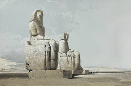
David Roberts - Obelisk of LuxorTrillium Antique Prints & Rare Books4.5(32)See Sold PriceFeb 24, 2024
David Roberts - Approach of the Simoom, Desert of GizehTrillium Antique Prints & Rare Books4.5(32)See Sold PriceFeb 24, 2024
De Jode, Rare, pub. 1593 - Map of the Middle East, Eastern Asia (Primae Partis Asiae accurataTrillium Antique Prints & Rare Books4.5(32)See Sold PriceFeb 24, 2024
WEST AFRICA Explorers' routes Senegal Ashanti. Mountains of Kong. SDUK 1857 mapJasper524.5(9.9k)See Sold PriceFeb 28, 2024
WEST AFRICA explorers' routes. Beaufort Gray Park Dochard Caillie. SDUK 1874 mapJasper524.5(9.9k)See Sold PriceFeb 28, 2024
WEST AFRICA I Explorers' routes Senegal Ashanti Ivory Gold Coast. SDUK 1851 mapJasper524.5(9.9k)See Sold PriceFeb 28, 2024
WEST AFRICA showing early explorers' routes & Mountains of Kong. SDUK 1844 mapJasper524.5(9.9k)See Sold PriceFeb 28, 2024
PRE COLONIAL WESTERN AFRICA. Shows Mountains of Kong. Tribes. WELLER 1863 mapJasper524.5(9.9k)See Sold PriceFeb 28, 2024
Vintage Framed Cat Island Nautical Map PrintRapid Estate Liquidators and Auction Gallery4.5(1.1k)See Sold PriceFeb 25, 2024


![[Middle, Near & Far East]. 3 Maps. (1 of 2)](https://p1.liveauctioneers.com/179/1435/617510_1_x.jpg?height=282&quality=70)


![[MAPS]. DUFOUR, Auguste-Henri (1795-1865). Bound Volume of ... (1 of 2)](https://p1.liveauctioneers.com/928/318880/171361279_1_x.jpg?height=282&quality=70&version=1707501302)