ATLAS of ANTIENT GEOGRAPHY by SAMUEL BUTLER 1843John McInnis Auctioneers,LLC4.6(502)See Sold PriceFeb 24, 2024
18TH C. ANTIQUE MAP: FRENCH & INDIAN WAR, FRAMEDThomaston Place Auction Galleries4.4(386)See Sold PriceFeb 24, 2024
Rand McNally Railroad Map Cabinet w/ 21 Railroad MapsRail & Road Auctions4.6(165)See Sold PriceMar 08, 2024
Keith Haring - Ink on New York Map, Best Buddies, Inscribed, Signed, and DatedSapphire Auction Gallery4(67)See Sold PriceMar 02, 2024
LATE 17TH C. FRENCH MAP OF THE NEW WORLD BY ALEXIS-HUBERT JAILLOT (1632-1712)Thomaston Place Auction Galleries4.4(386)See Sold PriceFeb 24, 2024
Central Railroad of New Jersey Map of Sandy Hook Route-ca. 1903JM Hobby Supply and Railroad Artifact Auctions4.4(126)See Sold PriceFeb 24, 2024
Lot of Six Mixed Atlas Box Cars-HO Scale-New in BoxJM Hobby Supply and Railroad Artifact Auctions4.4(126)See Sold PriceFeb 25, 2024
Rand McNally/Santa Fe Railroad Map of Iowa-1912JM Hobby Supply and Railroad Artifact Auctions4.4(126)See Sold PriceFeb 24, 2024
NICOLAES VISSCHER (NETHERLANDS, 1618-1709) MAP OF THE NEW WORLDThomaston Place Auction Galleries4.4(386)See Sold PriceFeb 24, 2024
17TH C. WORLD MAP BY NICOLAES VISSCHER (NETHERLANDS, 1618-1709)Thomaston Place Auction Galleries4.4(386)See Sold PriceFeb 24, 2024
Lot of Six Mixed Atlas Cabooses-HO Scale-New in BoxJM Hobby Supply and Railroad Artifact Auctions4.4(126)See Sold PriceFeb 25, 2024
Bellin / Arkstee & Merkus: Grenada, 1760Title/Content of Map: Bellin / Arkstee & Merkus: Grenada, 1760 Date Printed: 1760, Leipzig Cartographer: Bellin / Arkstee & Merkus Size: 6" x 8 1/4" Bellin's beautifully designed and detailed map of GSee Sold Price
Bellin / Arkstee & Merkus: Grenada, 1760Bellin's small map of Grenada for Prevost's influential Histoire Generale des Voyages. The map shows the island divided into parishes and includes many topographical details and place names and a decoSee Sold Price
Bellin / Arkstee & Merkus: Grenada, 1760Cartographer: Bellin / Arkstee&Merkus Place/Date: Leipzig / 1760 Size: 6" x 8 1/4" Condition: b&w; overall age toning; light browning and a few spots along margins Bellin's small map of Grenada for PrSee Sold Price
Bellin/Arkstee & Merkus: Antique Map of Grenada, 1760Karte von der Insel Grenada Bellin's small map of Grenada for Prevost's influential Histoire Generale des Voyages. The map shows the island divided into parishes and includes many topographical detailSee Sold Price
Bellin/Arkstee & Merkus: GrenadaReserve Reduced! Title of Map: Karte von der Insel Grenada Cartographer: Bellin / Arkstee&Merkus Place / Date: Leipzig / 1760 Size: 6" x 8 1/4" Condition: b&w; overall age toning; light browning and aSee Sold Price
Bellin / Arkstee & Merkus: GrenadaMap Title: Karte von der Insel Grenada Cartographer: Bellin / Arkstee&Merkus Place/Date: Leipzig / 1760 Size: 6" x 8 1/4" Condition: b&w; overall age toning; light browning and a few spots along margiSee Sold Price
Bellin / Arkstee & Merkus: GrenadaMap Title: Karte von der Insel GrenadaCartographer: Bellin / Arkstee&Merkus Place/Date: Leipzig / 1760 Size: 6" x 8 1/4" Condition: b&w; overall age toning; light browning and a few spots along marginSee Sold Price
Bellin / Arkstee & Merkus: GrenadaMap Title: Karte von der Insel Grenada Cartographer: Bellin / Arkstee&Merkus Place / Date: Leipzig / 1760 Size: 6" x 8 1/4" Condition: b&w; overall age toning; light browning and a few spots along marSee Sold Price
Bellin / Arkstee & Merkus: GrenadaMap Title: Karte von der Insel Grenada Cartographer: Bellin / Arkstee&Merkus Place / Date: Leipzig / 1760 Size: 6" x 8 1/4" Bellin's small map of Grenada for Prevost's influential Histoire Generale deSee Sold Price
Bellin / Arkstee & Merkus: GrenadaMap Title: Karte von der Insel Grenada Cartographer: Bellin / Arkstee&Merkus Place / Date: Leipzig / 1760 Size: 6" x 8 1/4" Condition: b&w; overall age toning; light browning and a few spots along marSee Sold Price
Bellin / Arkstee & Merkus: GrenadaMap Title: Karte von der Insel Grenada Cartographer: Bellin / Arkstee&Merkus Place / Date: Leipzig / 1760 Size: 6" x 8 1/4" Condition: b&w; overall age toning; light browning and a few spots along marSee Sold Price
SoldBellin / Arkstee & Merkus: Martinique, 1760Map Title: Karte von der Insel Martinique Cartographer: Bellin / Arkstee&Merkus Place / Date: Leipzig / 1760 Size: 11 3/4" x 7 3/4" Condition: b&w; overall age toning; some browning and spotting in thSee Sold Price
SoldBellin/Arkstee & Merkus: Antique Map of Barbados, 1760Karte von der Insel Barbade Bellin's small map of Barbados for Prevost's influential Histoire Generale des Voyages. The map shows the island divided into parishes and includes many topographical detaiSee Sold Price
Bellin: Grenada, 1760Title/Content of Map: Bellin: Grenada, 1760 Date Printed: 1760, Leipzig Cartographer: Jacques Nicolas Bellin / Arkstee & Merkus Size: 6" x 8 1/4" Bellin's beautifully designed and detailed map of GrenSee Sold Price
Bellin: Detailed 1760 Grenada MapTitle/Content of Map: Bellin: Detailed 1760 Grenada Map Date Printed: 1760, Leipzig Cartographer: Jacques Nicolas Bellin / Arkstee & Merkus Size: 6" x 8 1/4" Bellin's beautifully designed and detailedSee Sold Price
SoldBellin/Arkstee & Merkus: West Indies & Gulf of MexicoMap: Karte von dem Mexicanischen Meerbusen und dem Inseln von America Cartograper: Jacques Bellin / Arkstee & Merkus Place / Date: Leipzig / 1760 Size: 15" x 10 3/4" Condition: b&w. overall age toningSee Sold Price
SoldBellin/Arkstee & Merkus: Skulls Wall, Aztec Mexico CityBellin/Arkstee & Merkus: Wall of Skulls in Aztec Mexico City The notorious Wall of Skulls ("burial place of sacrificial victims") in the Templo Major of Aztec Mexico City, from the German edition of PSee Sold Price
SoldBellin/Arkstee & Merkus: Port of Veracruz, MexicoCartographer: Bellin / Arkstee&Merkus Place/Date: Leipzig / 1760 Size: 6 1/8" x 7 3/4" Condition: b&w; overall age toning and light browning and spotting along edges of margins Bellin's highly detaileSee Sold Price
SoldBellin / Arkstee & Merkus: St. LuciaCartographer: Bellin / Arkstee&Merkus Place/Date: Leipzig / 1760 Size: 11 1/2" x 7 3/4" Condition: b&w; light overall age toning Bellin's elegant and highly detailed map of St. Lucia for Prevost's infSee Sold Price
SoldBellin/Arkstee & Merkus: Aztec Sacrificial RitesBellin/Arkstee & Merkus: Aztec Worship & Human Sacrifice A grizzly scene of human sacrifice before a statue of Vitzliputzli (Huitzilopochtli), the "leading god of the Mexicans [Aztecs]" from the GermaSee Sold Price
Bellin/Arkstee & Merkus: Aztec Hieroglyphs (3 Sheets)Bellin/Arkstee & Merkus: Aztec Hieroglyphs (Three Sheets) Three plates of Aztec hieroglyphs from the German edition of Prevost d'Exile's Histoire Generale des Voyages, from left to right: Annals of thSee Sold Price
SoldBellin/Arkstee & Merkus: Environs of Aztec Mexico CityCartographer: Bellin / Arkstee&Merkus Place/Date: Leipzig / 1760 Size: 6 3/8" x 8 1/4" Condition: b&w; overall age toning and light browning; some nicks on outer edge of left margin Bellin's detailedSee Sold Price
Bellin / Arkstee & Merkus: MartiniqueReserve Reduced! Map Title: Karte von der Insel Martinique Cartographer: Bellin / Arkstee&Merkus Place/Date: Leipzig / 1760 Size: 11 3/4" x 7 3/4" Condition: b&w; overall age toning; some browning andSee Sold Price
Bellin/Arkstee & Merkus: Aztec Hieroglyphs (3 Sheets)Bellin/Arkstee & Merkus: Aztec Hieroglyphs (Three Sheets) Jahrgeschichte des Reichs/Landesproducte und Tribut/Mexanisches Hauswesen Three plates of Aztec hieroglyphs from the German edition of PrevostSee Sold Price
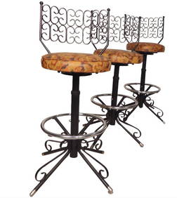
Set of 3 Arthur Umanoff "Grenada" StoolsA1 Consignment and Auction Gallery Inc4.4(16)See Sold PriceMar 07, 2024
Bugaku Mask, Emmani Men, by Deme Yasui, c. 1760The Scanlan Collection4.4(22)See Sold PriceFeb 24, 2024
1764 Bellin Map of Lesser Antilles Northern Portion -- Petites Antilles ou Isles du Vent 3e. Partie.Jasper524.5(9.8k)See Sold PriceFeb 27, 2024
1764 Bellin Map of Eastern Guadeloupe in the Lesser Antilles -- Partie Orientale de l'Isle de laJasper524.5(9.8k)See Sold PriceFeb 27, 2024
Map of Mexico, Central America, New Grenada, Venzuela and the West IndiesJasper524.5(9.8k)See Sold PriceFeb 27, 2024
1764 Bellin Map of Mari-Galante Near Guadeloupe -- Carte de l'Isle de Mari-GalanteJasper524.5(9.8k)See Sold PriceFeb 27, 2024
1764 Bellin Map of St. Kitts -- Carte de l'Isle St. ChristopheJasper524.5(9.8k)See Sold PriceFeb 27, 2024
1764 Bellin Map of Southern Portion of Martinique -- Partie Meridionale de la MartiniqueJasper524.5(9.8k)See Sold PriceFeb 27, 2024
1764 Bellin Map of Western Guadeloupe in the Lesser Antilles -- Partie Occidentale de l'Isle de laJasper524.5(9.8k)See Sold PriceFeb 27, 2024
1764 Bellin Map of Antigua -- Carte de l'Isle d'Antigue Situee par la Latitude 17 Degres et par laJasper524.5(9.8k)See Sold PriceFeb 27, 2024
1764 Bellin Chart of Three South Haitian Bays -- Carte des Bayes du Mesle des Flamands et deJasper524.5(9.8k)See Sold PriceFeb 27, 2024
1764 Bellin Map of Fort Louis Area of Guadeloupe -- Environs du Fort Louis de la GuadeloupeJasper524.5(9.8k)See Sold PriceFeb 27, 2024
1764 Bellin Map of Port Antonio, Jamaica -- Plan des Havres de Port Antonio et de Saint FrancoisJasper524.5(9.8k)See Sold PriceFeb 27, 2024
Coste Occidentale d’Afrique…' Arguin Bay Cap Blanc Mauritania. BELLIN 1746 mapJasper524.5(9.8k)See Sold PriceFeb 28, 2024
17.60 ctw Blue Sapphire & Diamond Earrings 18k White GoldPacific Global Auction3.9(272)See Sold PriceFeb 25, 2024
IN LATIN, MISSAE DEFUNCTORUM (1760) MISSAL ANTIQUE FOLIONY Elizabeth 4.3(84)See Sold PriceMar 03, 2024
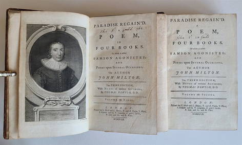
MILTON'S 1760 PARADISE REGAINED IN TWO VOLUMES WITH ANTIQUE ILLUSTRATED TEXTNY Elizabeth 4.3(84)See Sold PriceMar 03, 2024
Jacques Nicolas Bellin - Antique Map - Vue de la Rade de Tiniam, double antique coast view of theProverde Auctions4.3(3)See Sold PriceFeb 28, 2024
Jacques Nicolas Bellin - View of the entrance to Zihuatanejo Bay - View of the entrance to the portProverde Auctions4.3(3)See Sold PriceFeb 28, 2024
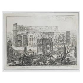
Giovanni Battista Piranesi (1720 Venice - 1778 Rome), 'Veduta dell'Arco di Costantino...' (1760) undQuittenbaum Kunstauktionen GmbH4.4(63)See Sold PriceMar 20, 2024