Sold[Americana - Alaska] Group of 4 Alaska Reports - Copper[Americana - Alaska] Group of 4 Alaska Reports - Copper River, Reindeer, Etc. -- Maps and Illustrations Allen, Lieut. Henry Tureman. REPORT OF AN EXPEDITION TO THE COPPER, TANANA AND KOYUKUK RIVERS ISee Sold Price
SoldA group of 4 maps of Chicago, comprising:A group of 4 maps of Chicago, comprising: New Commercial Atlas Map of Chicago District. Chicago: Rand McNally & Company. N.d. -- RICE, H.E. Rice's Pathfinder Map. N.p.: N.d. -- Standard Map of ChicagoSee Sold Price
Sold[MAPS OF CHICAGO AND ILLINOIS]. A group of 4 maps and[MAPS OF CHICAGO AND ILLINOIS]. A group of 4 maps and bird's-eye views of Chicago, comprising: MITCHELL. Augustus. Chicago. Pennsylvania, 1867. Engraved map of Chicago, hand-colored, image 13 1/4 x 11See Sold Price
Sold(MAP, FRANCE) A group of 4 maps.(MAP, FRANCE) A group of four maps of France and French regions. Size of largest 13 3/4 x 17 1/4 inches.See Sold Price
SoldCartography12. Cartography.Group of 4 maps, as listed below. Various sizes; light wear. Vp, vd [75/100]Russia in Europe. Plate 21 of Johnston's National Atlas. 25-1/2 x 21 inches. 1850s * ditto. Plate 55 of MitcSee Sold Price
SoldGroup of [4] World Maps by Various CartographersGroup of four World Maps by various cartographers and publishers. 1) W. Houghs "The World as Known to the Ancients" published by A. & C. Black. Measures 17.5" x 12.5" sheet size. 2) Engraved by J. WilSee Sold Price
SoldGroup of 4 Antique Maps Of FranceBouches du Rhone, Aude Dept de L'Hercault, Gard & Herault. Dresse par A. Vuillemin Geographe. Ecrit par Isidore. Frames 13.75" x 12.75" image sight: 9" x 7". In estate found condition, some foxing.See Sold Price
SoldBarlow 1807 Group of 4 European MapsIncl Russia, England/Wales, Sweden/Denmark/Norway/Finland and Turkey in Europe. Copper Engraved Maps Published 1807 by Brightly & Kinnersley, Bungay, England for "A General View of the World, GeographSee Sold Price
SoldGroup (4) Henry Evans, American (1918-1990) signed &Group (4) Henry Evans, American (1918-1990) signed & numbered linocuts. All are framed measuring 21.75'' x 13.75''See Sold Price
Group of 4 Antique MapsBouches du Rhone, Aude Dept de L'Hercault, Gard & Herault. Dresse par A. Vuillemin Geographe. Ecrit par Isidore. Frames 13.75" x 12.75" image sight: 9" x 7". In estate found condition, some foxing.See Sold Price
SoldWALCH, Johann (1757–1816). A group of 4WALCH, Johann (1757–1816). A group of 4 hemisphere maps. Augsburg, 1787. Each 203 x 260 mm. Hand–colored engravings of the Northern, Southern, Western, and Eastern hemispheres. (Some margiSee Sold Price
SoldA 14K GOLD, TURQUOISE GEORGE HENRY NAVAJO JEWELRYA 14K GOLD, TURQUOISE GEORGE HENRY NAVAJO JEWELRY GROUP 4 piece circa 1978 comprising a 4 nugget Morenci turquoise, 14k gold bracelet by George Henry together with a similar 14k gold ring by Nusie HenSee Sold Price
SoldWyld, James C1840 Group of 4 Hand Coloured MapsIncl Spain/Portugal, Syria, Asia and Turkey in Asia. Hand Coloured Steel Engraved Map Published C1840, London for "Atlas of Modern Geography" by James Wyld. Centre fold as published. Paper Size: 11 xSee Sold Price
SoldVuillemin, A 1848 Group of 4 Decorative French MapsCharente Inferieure, Cher, Cantal, Charente. Steel Engraved Maps Published 1848, Paris for "La France et ses colonies" by Alexandre Vuillemin & Migeon. Paper Size: 13 x 10 inch (33 x 25cm) Good ConditSee Sold Price
SoldVuillemin, A 1848 Group of 4 Decorative French MapsAin, Aisne, Allier, Bses Alpes. Steel Engraved Maps Published 1848, Paris for "La France et ses colonies" by Alexandre Vuillemin & Migeon. Paper Size: 13 x 10 inch (33 x 25cm) Good ConditionSee Sold Price
SoldVuillemin, A 1848 Group of 4 Decorative French MapsFinistere, Gard, Hte Garonne, Gers. Steel Engraved Maps Published 1848, Paris for "La France et ses colonies" by Alexandre Vuillemin & Migeon. Paper Size: 13 x 10 inch (33 x 25cm) Good ConditionSee Sold Price
SoldVuillemin, A 1848 Group of 4 Decorative French MapsLozere, Lot, Loirret, and Lot et Garonne. Steel Engraved Maps Published 1848, Paris for "La France et ses colonies" by Alexandre Vuillemin & Migeon. Paper Size: 13 x 10 inch (33 x 25cm) Good ConditionSee Sold Price
SoldVuillemin, A 1848 Group of 4 Decorative French MapsDoubs, Drome, Eure, Eure et Loire. Steel Engraved Maps Published 1848, Paris for "La France et ses colonies" by Alexandre Vuillemin & Migeon. Paper Size: 13 x 10 inch (33 x 25cm) Good ConditionSee Sold Price
SoldVuillemin, A 1848 Group of 4 Decorative French MapsHte Marne, Manche, Maine et Loire and Marne. Steel Engraved Maps Published 1848, Paris for "La France et ses colonies" by Alexandre Vuillemin & Migeon. Paper Size: 13 x 10 inch (33 x 25cm) Good ConditSee Sold Price
SoldVuillemin, A 1848 Group of 4 Decorative French MapsHtes Alpes, Ardeche, Ardennes, Ariege. Steel Engraved Maps Published 1848, Paris for "La France et ses colonies" by Alexandre Vuillemin & Migeon. Paper Size: 13 x 10 inch (33 x 25cm) Good ConditionSee Sold Price
SoldVuillemin, A 1848 Group of 4 Decorative French MapsCorreze, Cote-D'Or, Cotes du Nord, Creuse. Steel Engraved Maps Published 1848, Paris for "La France et ses colonies" by Alexandre Vuillemin & Migeon. Paper Size: 13 x 10 inch (33 x 25cm) Good ConditioSee Sold Price
SoldVuillemin, A 1848 Group of 4 Decorative French MapsLandes, Jura, Isere, and Indre et Loire. Steel Engraved Maps Published 1848, Paris for "La France et ses colonies" by Alexandre Vuillemin & Migeon. Paper Size: 13 x 10 inch (33 x 25cm) Good ConditionSee Sold Price
SoldVuillemin, A 1848 Group of 4 Decorative French MapsIndre, Ille et Vilaine, Herault, and Gironde. Steel Engraved Maps Published 1848, Paris for "La France et ses colonies" by Alexandre Vuillemin & Migeon. Paper Size: 13 x 10 inch (33 x 25cm) Good CondiSee Sold Price
SoldVuillemin, A 1848 Group of 4 Decorative French MapsHte Loire, Loire, Loire-Infre, and Loir et Cher. Steel Engraved Maps Published 1848, Paris for "La France et ses colonies" by Alexandre Vuillemin & Migeon. Paper Size: 13 x 10 inch (33 x 25cm) Good CoSee Sold Price
Group of 4 Kashmir, India, approx. 40 years, syntheticHenry's Auktionshaus AG4.3(206)See Sold PriceMar 02, 2024
Eight Gulf, Mobile & Ohio Railroad Playing Card Decks - Alton Route Map and LogoRail & Road Auctions4.6(165)See Sold PriceMar 08, 2024
Group of Three Silver Mardi Gras Items, 20th c., Cup- H.- 4 in., Dia.- 3 1/4 in., Sterling Wt.- 5.8Crescent City Auction Gallery4.3(231)See Sold PriceMar 01, 2024
[LITHOGRAPHY]. Group of 42 Trade Cards or Collector’s Cards...Potter & Potter Auctions4.6(545)See Sold PriceMar 07, 2024
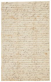
CARVER, George Washington (ca 1864-1943). Two TLsS ("G.W. Carver"), April and October 1936.[With:]Freeman's | Hindman4.4(1.6k)See Sold PriceFeb 27, 2024
Group of 12 Mold-O-Rama Plastic Mold SouvenirsMatthew Bullock Auctioneers4.7(1.8k)See Sold PriceFeb 24, 2024
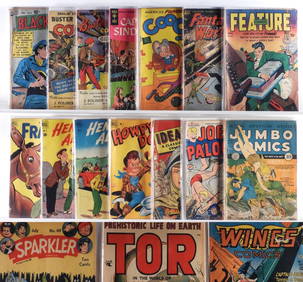
21PC Fiction House Quality Dell Golden Age ComicsBruneau & Co. Auctioneers4.5(491)See Sold PriceFeb 24, 2024
Group of 7 Standard, Pure, Gulf, Texaco Service Station MapsCheck the Oil Promotions, LLC4.6(327)See Sold PriceMar 03, 2024
Group of 5 1934 Sinclair Graphic Road MapsCheck the Oil Promotions, LLC4.6(327)See Sold PriceMar 03, 2024
HOWARD ZIEFF (1927-2009) YOU DON'T HAVE TO BE JEWISH TO LOVE LEVY'S. Group of 4 posters. 1967.Swann Auction Galleries4.4(70)See Sold PriceFeb 29, 2024
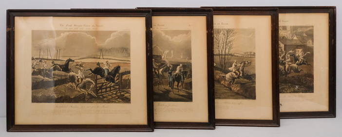
After H. Alken, Group of 4 Steeplechase PrintsOld Kinderhook Auction Company4.6(217)See Sold PriceMar 05, 2024
Fielding (Henry) The Works, with An Essay on His Life and Genius by Arthur Murphy, 10 vol., newForum Auctions4.3(53)See Sold PriceFeb 29, 2024

![[Americana - Alaska] Group of 4 Alaska Reports - Copper (1 of 10)](https://p1.liveauctioneers.com/46/113409/58240907_1_x.jpg?height=282&quality=70&version=1512492316)


![[MAPS OF CHICAGO AND ILLINOIS]. A group of 4 maps and (1 of 3)](https://p1.liveauctioneers.com/197/128324/65283842_1_x.jpg?height=282&quality=70&version=1537814359)


![Group of [4] World Maps by Various Cartographers (1 of 5)](https://p1.liveauctioneers.com/5755/131248/66701959_1_x.jpg?height=282&quality=70&version=1542156595)


![[LITHOGRAPHY]. Group of 42 Trade Cards or Collector’s Cards... (1 of 1)](https://p1.liveauctioneers.com/928/318880/171361099_1_x.jpg?height=282&quality=70&version=1707501302)
![CARVER, George Washington (ca 1864-1943). Two TLsS ("G.W. Carver"), April and October 1936.[With:] (1 of 2)](https://p1.liveauctioneers.com/197/319238/171467840_1_x.jpg?height=282&quality=70&version=1707520367)