ATLAS of ANTIENT GEOGRAPHY by SAMUEL BUTLER 1843John McInnis Auctioneers,LLC4.6(502)See Sold PriceFeb 24, 2024
18TH C. ANTIQUE MAP: FRENCH & INDIAN WAR, FRAMEDThomaston Place Auction Galleries4.4(386)See Sold PriceFeb 24, 2024
Rand McNally Railroad Map Cabinet w/ 21 Railroad MapsRail & Road Auctions4.6(165)See Sold PriceMar 08, 2024
Keith Haring - Ink on New York Map, Best Buddies, Inscribed, Signed, and DatedSapphire Auction Gallery4(67)See Sold PriceMar 02, 2024
LATE 17TH C. FRENCH MAP OF THE NEW WORLD BY ALEXIS-HUBERT JAILLOT (1632-1712)Thomaston Place Auction Galleries4.4(386)See Sold PriceFeb 24, 2024
Central Railroad of New Jersey Map of Sandy Hook Route-ca. 1903JM Hobby Supply and Railroad Artifact Auctions4.4(126)See Sold PriceFeb 24, 2024
Lot of Six Mixed Atlas Box Cars-HO Scale-New in BoxJM Hobby Supply and Railroad Artifact Auctions4.4(126)See Sold PriceFeb 25, 2024
Rand McNally/Santa Fe Railroad Map of Iowa-1912JM Hobby Supply and Railroad Artifact Auctions4.4(126)See Sold PriceFeb 24, 2024
NICOLAES VISSCHER (NETHERLANDS, 1618-1709) MAP OF THE NEW WORLDThomaston Place Auction Galleries4.4(386)See Sold PriceFeb 24, 2024
17TH C. WORLD MAP BY NICOLAES VISSCHER (NETHERLANDS, 1618-1709)Thomaston Place Auction Galleries4.4(386)See Sold PriceFeb 24, 2024
Lot of Six Mixed Atlas Cabooses-HO Scale-New in BoxJM Hobby Supply and Railroad Artifact Auctions4.4(126)See Sold PriceFeb 25, 2024
SoldBARTHOLOMEW'S HALF INCH TO MILE MAPS dissected andBARTHOLOMEW'S HALF INCH TO MILE MAPS dissected and mounted on cloth set of 30 folding maps of SCOTLAND, complete set in original leather case marked 'SCOTLAND' L: 34cm approx W: 22cm approx Approx 30See Sold Price
Bartholomew's "Half-Inch to Mile" Map of Scotland.Title: Bartholomew's "Half-Inch to Mile" Map of Scotland. Sheet 8. Edinburgh District Date: c1910 Cartographer: BARTHOLOMEW, JOHN Publisher: THE EDINBURGH GEOGRAPHICAL INSTITUTE, JOHN BARTHOLOMEW & SOSee Sold Price
SoldBENG A large mixed group of maps of the U.K.BENG A large mixed group of maps of the U.K.including editions of Bartholomew's Half-Inch to Mile Map of England & Wales, with editions of Ordnance Survey New Popular Edition One-Inch MapsSee Sold Price
Bartholomew's "Half Inch to the Mile" Map of EnglandTitle: Bartholomew's "Half Inch to the Mile" Map of England And Wales. Sheet 3. Cumberland. [Lake District] Cartographer: Bartholomew, John Publisher: The Edinburgh Geographical Institute, John BarthoSee Sold Price
Bartholomew's "Half Inch to the Mile" Map of EnglandTitle: Bartholomew's "Half Inch to the Mile" Map of England And Wales. Sheet 37. Cornwall. Publication Date: c1920 Cartographer: BARTHOLOMEW, JOHN Publisher: THE EDINBURGH GEOGRAPHICAL INSTITUTE, JOHNSee Sold Price
Bartholomew's "Half Inch to the Mile" Map of England &Title: Bartholomew's "Half Inch to the Mile" Map of England & Wales. Sheet 25. Bedford, Hertford, &C. Cartographer: Bartholomew, John & Son. Publisher: The Edinburgh Geographical Institute, John BarthSee Sold Price
Bartholomew's Revised "Half-Inch" Map of English LakesTitle/Content of Map: Bartholomew's Revised "Half-Inch" Map of English Lakes Great Britain Sheet 34 Date: c1950 Cartographer: BARTHOLOMEW, JOHN Publisher: THE EDINBURGH GEOGRAPHICAL INSTITUTE, JOHN BASee Sold Price
Bartholomew's Revised Half-Inch Map. Great Britain.Title: Bartholomew's Revised Half-Inch Map. Great Britain. Sheet 30. Lincolnshire. Cartographer: BARTHOLOMEW, JOHN & SON Publisher: The Geographical Institute, John Bartholomew & Son Ltd. Brief DescriSee Sold Price
Bartholomews revised half inch contoured maps withBartholomews revised half inch contoured maps with case, for library referenceSee Sold Price
SoldA large quantity of maps, to include Bartholomew'sA large quantity of maps, to include Bartholomew's revised 'half-inch' contoured maps, to include Dorset, Argyll, Oxford, Herts & Bucks, Surrey, Cambridge, Kent, Pembroke, North Wales, the Lake DistriSee Sold Price
SoldA large quantity of maps, to include Bartholomew'sA large quantity of maps, to include Bartholomew's revised 'half-inch' contoured maps, to include Dorset, Argyll, Oxford, Herts & Bucks, Surrey, Cambridge, Kent, Pembroke, North Wales, the Lake DistriSee Sold Price
SoldA large quantity of maps, to include Bartholomew'sA large quantity of maps, to include Bartholomew's revised 'half-inch' contoured maps, to include Dorset, Argyll, Oxford, Herts & Bucks, Surrey, Cambridge, Kent, Pembroke, North Wales, the Lake DistriSee Sold Price
SoldBartholomews revised half inch contouredBartholomews revised half inch contoured maps, 65 cloth backed mapsSee Sold Price
Bartholomew's "Quarter Inch to the Mile" Map of EnglandTitle: Bartholomew's "Quarter Inch to the Mile" Map of England And Wales. Sheet 10. Devon. Cartographer: BARTHOLOMEW, JOHN Publisher: THE EDINBURGH GEOGRAPHICAL INSTITUTE, JOHN BARTHOLOMEW & SON LTD.See Sold Price
Collection of Various Maps Consisting of Bartholomew’sCollection of Various Maps Consisting of Bartholomew's Half Inch, Harmsworth Atlas Motor Maps (Box)See Sold Price
SoldBacon (G.W.) - Gifford's Flexible Pocket Map of London,Divided into half mile squares & circles, Scale Four Inches to the Mile, folding cloth map from Islington to Oval, and from Stepney to Notting Hill, engraved map printed in fine linen, 490 x 680mm., sSee Sold Price
Bartholomew's One Inch to the Mile Environs of LondonTitle: Bartholomew's One Inch to the Mile Environs of London Publication Date: c1925 Cartographer: BARTHOLOMEW, JOHN Publisher: JOHN BARTHOLOMEW & SON, LTD. THE GEOGRAPHICAL INSTITUTE Dimension: 27.75See Sold Price
Bartholomew's One Inch to the Mile Environs of LondonPublication Date: c1925 Title: Bartholomew's One Inch to the Mile Environs of London Cartographer: BARTHOLOMEW, JOHN Publisher: JOHN BARTHOLOMEW & SON, LTD. THE GEOGRAPHICAL INSTITUTE Height: 27.75 WiSee Sold Price
SoldOld 1783 Folding Map of LONDON, EnglandAbout 24" square. Map of the Country Twenty-Two Miles Round London compiled from Actual Surveys on a scale of Half an Inch to a Mile by Wallis, published by J Wallis, London 1783. Engraved by WoodmanSee Sold Price
SoldCary (John)Cary (John) Actual Survey of the Country Fifteen Miles Round London, On a Scale of one Inch to a Mile, engraved map with original hand-colouring, 765 x 885mm., dissected and linen-backed, trimSee Sold Price
SoldCRUCHLEY A NEW MAP OF ENGLANDG.F.Cruchley A New Map of England ('Adapted for Elementary Instruction in National Schools') scale 14.5 miles to 1 inch coloured lithographic dissected map backed onto linen 80 x 64cmSee Sold Price
SoldCRUCHLEY A NEW MAP OF ENGLANDG.F.Cruchley A New Map of England ('Adapted for Elementary Instruction in National Schools') scale 14.5 miles to 1 inch coloured lithographic dissected map backed onto linen 80 x 64cmSee Sold Price
Bartholomew's Four Miles to the Inch Road Map ofTitle: Bartholomew's Four Miles to the Inch Road Map of England And Wales. New Series Sheet 12. Surrey, Sussex & Kent. Cartographer: BARTHOLOMEW, JOHN & CO. Publisher: THE EDINBURGH GEOGRAPHICAL INSTISee Sold Price
Cycling" Map of England And Wales.Title/Content of Map: Cycling" Map of England And Wales. Date: c1912 Cartographer: BARTHOLOMEW, J. Publisher: CYCLING WEEKLY Size: 33.5Height - 27.5Width Scale 13 miles to the inch. By J. Bartholomew,See Sold Price
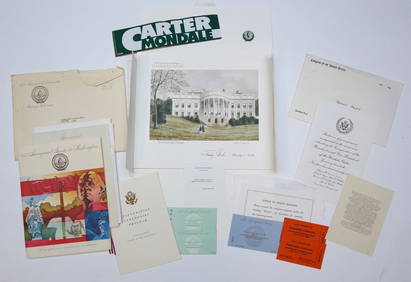
1977 INAUGURATION of PRESIDENT JIMMY CARTERJohn McInnis Auctioneers,LLC4.6(502)See Sold PriceFeb 25, 2024
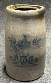
Beautiful Original 1 Gallon Salt Glazed Jar w/ Floral DecorationHoller and Hammer4.5(47)See Sold PriceFeb 24, 2024
Group of Doll House Miniature Stoneware and MoreMatthew Bullock Auctioneers4.7(1.8k)See Sold PriceFeb 24, 2024
Jacoulet Woodblock - Les Graines de Camelia. OshimaFloating World Auctions4.7(233)See Sold PriceMar 01, 2024
AFRICA. French West Africa. Rio de Oro Rio Muni Nigeria. BARTHOLOMEW 1952 mapJasper524.5(9.8k)See Sold PriceFeb 28, 2024
AFRICA. Pre 'Scramble for Africa'. BARTHOLOMEW 1876 old antique map plan chartJasper524.5(9.8k)See Sold PriceFeb 28, 2024
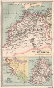
Algeria Morocco & Tunis. North Africa. Tunisia. Maghreb. BARTHOLOMEW 1898 mapJasper524.5(9.8k)See Sold PriceFeb 28, 2024
COLONIAL CENTRAL AFRICA. Congo German East Africa Rhodesia. BARTHOLOMEW 1898 mapJasper524.5(9.8k)See Sold PriceFeb 28, 2024
MOROCCO LIBERIA & MAURITIUS. Sierra Leone. BARTHOLOMEW 1886 old antique mapJasper524.5(9.8k)See Sold PriceFeb 28, 2024
NORTH AFRICA. 'Biledulgerid', a former North African country. MALLET 1683 mapJasper524.5(9.8k)See Sold PriceFeb 28, 2024
Central Africa. Congo Zambia Tanzania Kenya Mozambique. BARTHOLOMEW 1886 mapJasper524.5(9.8k)See Sold PriceFeb 28, 2024
NORTH AFRICA. Morocco Algeria Tunis Tunisia Egypt. Cairo. BARTHOLOMEW 1912 mapJasper524.5(9.8k)See Sold PriceFeb 28, 2024
NORTH AFRICA. Morocco Algeria Tunis Tunisia Egypt. Cairo. BARTHOLOMEW 1901 mapJasper524.5(9.8k)See Sold PriceFeb 28, 2024
NORTH AFRICA. Algeria Morocco Tunis Tunisia Maghreb. BARTHOLOMEW 1891 old mapJasper524.5(9.8k)See Sold PriceFeb 28, 2024
6.5 CTW 14K Solid White Gold Miles To Go Blue Topaz Necklace3 Kings Auction4.3(194)See Sold PriceFeb 24, 2024
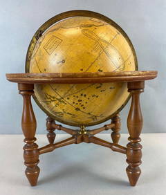
Antique Josiah Loring Terrestrial 1850s GlobeMatthew Bullock Auctioneers4.7(1.8k)See Sold PriceMar 02, 2024
6.5 CTW 14K Solid White Gold Miles To Go Blue Topaz NecklaceGolden Air Auctions4.4(257)See Sold PriceFeb 25, 2024
MALLARD DRAKE, R. LIBENSPERGERFrank and Frank Sporting Collectibles LLC4.7(166)See Sold PriceMar 10, 2024