SoldBartholomew (J) East Coast of South AmericaBartholomew (John) East Coast of South America, Brazil, Middle Provinces,east coast of Brazil and the province of Rio de Janeiro, 2 engraved maps on one sheet with original hand-colouring, sheSee Sold Price
Swanston: Map of East Coast of South America, 1850Map: East Coast of South America Brazil Middle Provinces Maker: Bartholomew, J. / G.H. Swanston Published: 1850 Publisher: A. Fullarton & Co. Size: Folio, 18.5 x 12 inches From Mahlmann's maps of BrazSee Sold Price
Bartholomew: Map of East Coast of South America, 1850Map: East Coast of South America Brazil Middle Provinces Date: 1850 Authors: A. Fullarton & Co., BARTHOLOMEW, J./G. H. SWANSTON Publisher: A. Fullarton & Co. 1850 ca. LONDON/EDINBURGH/DUBLIN Size: FolSee Sold Price
Bartholomew: Map of East Coast of South America, 1850Map: East Coast of South America Brazil Middle Provinces Date: 1850 Authors: A. Fullarton & Co., BARTHOLOMEW, J./G. H. SWANSTON Publisher: A. Fullarton & Co. Size: Folio – 18.50 H x 12.00 W Inches FSee Sold Price
East Coast of South America Brazil Middle ProvincesTitle: East Coast of South America Brazil Middle Provinces Prublication Date: c1850 Cartographer: BARTHOLOMEW, J./G. H. SWANSTON Publisher: A. Fullarton & Co. Size: 18.5Height - 12Width Additional InfSee Sold Price
SoldJohn Bartholomew, "East Coast of South America, Brazil,John Bartholomew, "East Coast of South America, Brazil, Middle Provinces," east coast of Brazil and the province of Rio de Janeiro, 1856, by A. Fullarton & Co., consisting of two engraved maps on oneSee Sold Price
Two unframed nautical charts to include: an 1857chart of the South Atlantic Ocean, compiled by J. S. Hobbs, including the East and West coast of South America, and the West Coast of Africa to Cape Colony. Includes closeups of Rio de Janeiro, PernamSee Sold Price
SoldBellin (J N) Carte de L'Ocean MerisionalBellin (Jacques Nicolas) Carte de L'Ocean Merisional,the south Atlantic Ocean showing the east coast of South America from the mouth of the river Amazon to Tierra del Fuego, and the west coastSee Sold Price
SoldTWO 19TH CENTURY MAPS OF BRAZILIncludes a J.H. Colton & Co. map of Brazil and Guayana, 1855, professionally matted, 16.75 x 14 inch sight size. Also the East Coast of South America, Brazil and middle provinces, from the Royal IllusSee Sold Price
SoldOrtelius Map of Florida[America, East Coast, South America] ORTELIUS, Abraham (1527-1598). La Florida / Guastecan / Peruviae... Engraved map with original hand color in full. Amsterdam, 1584 or later. 17 1/2" x 21" sheet, 2See Sold Price
SoldEast Coast of South America Included Between the RiversReserve Reduced! Title: East Coast of South America Included Between the Rivers Para and La Plata Publication Date: 1886 Cartographer: IMRAY, JAMES F. Publisher: JAMES IMLAY & SON Size (inches): 41.25See Sold Price
East Coast of South America. Rio De La Plata andTitle: East Coast of South America. Rio De La Plata and Approaches Prublication Date: 1896-08-08 Cartographer: FILLMORE, JOHN H./H. G. BREWER Publisher: HYDROGRAPHIC OFFICE. U.S. NAVY Size: 24.5HeightSee Sold Price
East Coast of South America. Rio De La Plata andTitle/Content of Map: East Coast of South America. Rio De La Plata and Approaches Date Printed: 1896-08-08 Cartographer: FILLMORE, JOHN H./H. G. BREWER Size: 24.5X45.5 "Compiled from the latest informSee Sold Price
Sold17th Century S. American Map and Engraving, 2 item1st item: A framed 17th century colored engraved map titled "Guiana Sive Amazonum Regio". Showing the North East coast of South America between the Orinoco river and the Amazon and the inlanSee Sold Price
SoldBrazil. South America East Coast. Bahia. Rio deTITLE/CONTENT OF MAP: 'East Coast of South America; Brazil, Middle Provinces // East coast of Brazil; Bahia, Sergipe, Alagoas and part of Pernambuco // Province of Rio de Janeiro Brazil from the map oSee Sold Price
SoldGeelkerken (Nicolaas Van) Chart of the Pacific OceGeelkerken (Nicolaas Van) Chart of the Pacific Ocean,plotting the course of Jacob le Mair from the south east coast of South America to New Guinea, with inset charts of the latter and Tierra dSee Sold Price
Insets: Rio De Janiero, Santos, Etc.Imray, James F. (1829-1891). East Coast of South America Included Between the Rivers Para and La Plata. Lithographed map. James Imray & Son, 1886. 41 ¼" x 79" sheet. Very large blue back chart of tSee Sold Price
SoldSouth America East Coast: Sheet X. PatagoniaPatagonien. - South America East Coast. Sheet X. Patagonia. Cape three points to the strait of Magellan. Seekarte zu 12 Segmenten auf Leinen montiert. 65 x 50 cm. Gefaltet und montiert in HalbleinenbaSee Sold Price
Sold1822 Chart of South AmericaFramed, blueback, early 19th century chart of the east and west coast of South America from The River Plate to Valparaiso, including the Falkland Islands with plans of the principal harbours. This pieSee Sold Price
Sold1822 Chart of South AmericaFramed, blueback, early 19th century chart of the east and west coast of South America from The River Plate to Valparaiso, including the Falkland Islands with plans of the principal harbours. This pieSee Sold Price
1822 Chart of South AmericaFramed, blueback, early 19th century chart of the east and west coast of South America from The River Plate to Valparaiso, including the Falkland Islands with plans of the principal harbours. This pieSee Sold Price
Sold1822 Chart of South AmericaFramed, blueback, early 19th century chart of the east and west coast of South America from The River Plate to Valparaiso, including the Falkland Islands with plans of the principal harbours. This pieSee Sold Price
1950s PanAm Route Map of South America's East Coast --Title/Content of Map: 1950s PanAm Route Map of South America's East Coast -- Pan American Flight Map, South America East Coast Cartographer: PanAm Year/Place: late 1950s c. Size: 23.5 X 16.8 in. foldeSee Sold Price
1950s PanAm Route Map of South America's East Coast --Title: 1950s PanAm Route Map of South America's East Coast -- Pan American Flight Map, South America East Coast Date: late 1950s c. Cartographer: PanAm Size: 23.5 X 16.8 in. folded out Additional InfoSee Sold Price
British School, Pair of English Landscapes, c. 1948, Coast- H.- 8 3/8 in., W.- 10 3/8 in., Framed-Crescent City Auction Gallery4.3(229)See Sold PriceMar 01, 2024
Antique Set of 800 Silver Featuring Ornate Art Nouveau Lily PatternCollective Hudson4.5(54)See Sold PriceMar 01, 2024
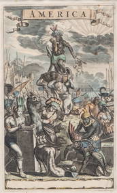
Antique Hand Colored Print "America" by Jacob van MeursCollective Hudson4.5(54)See Sold PriceMar 01, 2024
350 piece +/- Zwilling J.A. Henckels .800 Silver Flatware ServiceCollective Hudson4.5(54)See Sold PriceMar 01, 2024
Two oil paintings of "L'Avenir" Early 20th Century Oil on Canvas Ship Paintings one signed A. J.Collective Hudson4.5(54)See Sold PriceMar 01, 2024
[UPRISING OF ENSLAVED PEOPLE]. American Eagle. No. 1. Salem, MA: Thomas C. Cushing, 5 January 1790.Freeman's | Hindman4.4(1.6k)See Sold PriceFeb 27, 2024
Mexico, Central America and West Indies Physical PoliticalJasper524.5(9.8k)See Sold PriceFeb 27, 2024
Southern Africa Cape of Good Hope-Madagascar ADMIRALTY sea chart 1935 (1955) mapJasper524.5(9.8k)See Sold PriceFeb 28, 2024
Coste Orientale d’Afrique…' South Africa. Mozambique channel. BELLIN 1746 mapJasper524.5(9.8k)See Sold PriceFeb 28, 2024
East coast of Africa from the Cape… South Africa Mozambique. CHILD 1745 mapJasper524.5(9.8k)See Sold PriceFeb 28, 2024
Coste Orientale d’Afrique'. South Africa Mozambique BELLIN/SCHLEY 1747 mapJasper524.5(9.8k)See Sold PriceFeb 28, 2024
TWO ANTIQUE JEWISH NATIONAL FUND CHARITY BOXES. The first one made in Berlin c. 1920J. Greenstein & Co., Inc.4.3(55)See Sold PriceApr 16, 2024


![[UPRISING OF ENSLAVED PEOPLE]. American Eagle. No. 1. Salem, MA: Thomas C. Cushing, 5 January 1790. (1 of 3)](https://p1.liveauctioneers.com/197/319238/171468013_1_x.jpg?height=282&quality=70&version=1707520367)


