ATLAS of ANTIENT GEOGRAPHY by SAMUEL BUTLER 1843John McInnis Auctioneers,LLC4.6(502)See Sold PriceFeb 24, 2024
18TH C. ANTIQUE MAP: FRENCH & INDIAN WAR, FRAMEDThomaston Place Auction Galleries4.4(386)See Sold PriceFeb 24, 2024
Rand McNally Railroad Map Cabinet w/ 21 Railroad MapsRail & Road Auctions4.6(165)See Sold PriceMar 08, 2024
Keith Haring - Ink on New York Map, Best Buddies, Inscribed, Signed, and DatedSapphire Auction Gallery4(67)See Sold PriceMar 02, 2024
LATE 17TH C. FRENCH MAP OF THE NEW WORLD BY ALEXIS-HUBERT JAILLOT (1632-1712)Thomaston Place Auction Galleries4.4(386)See Sold PriceFeb 24, 2024
Central Railroad of New Jersey Map of Sandy Hook Route-ca. 1903JM Hobby Supply and Railroad Artifact Auctions4.4(126)See Sold PriceFeb 24, 2024
Lot of Six Mixed Atlas Box Cars-HO Scale-New in BoxJM Hobby Supply and Railroad Artifact Auctions4.4(126)See Sold PriceFeb 25, 2024
Rand McNally/Santa Fe Railroad Map of Iowa-1912JM Hobby Supply and Railroad Artifact Auctions4.4(126)See Sold PriceFeb 24, 2024
NICOLAES VISSCHER (NETHERLANDS, 1618-1709) MAP OF THE NEW WORLDThomaston Place Auction Galleries4.4(386)See Sold PriceFeb 24, 2024
17TH C. WORLD MAP BY NICOLAES VISSCHER (NETHERLANDS, 1618-1709)Thomaston Place Auction Galleries4.4(386)See Sold PriceFeb 24, 2024
Lot of Six Mixed Atlas Cabooses-HO Scale-New in BoxJM Hobby Supply and Railroad Artifact Auctions4.4(126)See Sold PriceFeb 25, 2024
Asher and Adams: Antique Map of Florida, 1872Title/Content of Map: 1872 Asher and Adams Map of Florida -- Asher & Adams' Florida Date Printed: 1872 New York Cartographer: Asher & Adams Size: 15.8 x 22.8 in. A very nice, large map of Florida. TheSee Sold Price
1872 Asher and Adams Antique Map of FloridaTitle/Content of Map: 1872 Asher and Adams Map of Florida -- Asher & Adams' Florida Date Printed: 1872 New York Cartographer: Asher & Adams Size: 15.8 x 22.8 in. A very nice, large map of Florida. TheSee Sold Price
Asher & Adams: Antique Map of Europe, 1872Map: 1872 Asher & Adams Map of Europe -- Asher and Adams' Europe Cartographer: Asher & Adams Year / Place: 1872, New York Map Dimensions: 16 X 23 Condition: Very good. Very slight toning. A small spliSee Sold Price
Asher & Adams: Antique Map of Europe, 1872Title/Content of Map: 1872 Asher & Adams Map of Europe -- Asher and Adams' Europe Date Printed: 1872, New York Cartographer: Asher & Adams Size: 16 X 23 in. An attractive map of Europe showing rivers,See Sold Price
Asher & Adams: Antique Map of Europe, 1872Title/Content of Map: 1872 Asher & Adams Map of Europe -- Asher and Adams' Europe Date Printed: 1872, New York Cartographer: Asher & Adams Size: 16 X 23 in. An attractive map of Europe showing rivers,See Sold Price
Asher & Adams: Antique Map of Europe, 1872Map: 1872 Asher & Adams Map of Europe -- Asher and Adams' Europe Date Printed: 1872, New York Cartographer: Asher & Adams Size: 16 X 23 in. Condition: Very good. Very slight toning. A small split in lSee Sold Price
Asher and Adams: Antique Map of United States, 1872Title/Content of Map: 1872 Asher and Adams Map of United States -- Asher & Adams' United States and Territories Date Printed: 1872 New York Cartographer: Asher & Adams Size: 15.8 x 22.8 in. A very nicSee Sold Price
Sold1872 Asher and Adams Map of Florida -- Asher & Adams'Title/Content of Map: 1872 Asher and Adams Map of Florida -- Asher & Adams' Florida Date: 1872 New York Cartographer: Asher & Adams Size: 15.8 x 22.8 in. A very nice, large map of Florida. The major cSee Sold Price
SoldAsher and Adams: Antique Map of North/South CarolinaTitle/Content of Map: 1872 Asher and Adams Map of North Carolina and South Carolina -- Asher & Adams' North Carolina, South Carolina Date Printed: 1872 New York Cartographer: Asher & Adams Size: 15.8See Sold Price
Asher and Adams: Antique Map of Virginia, West VirginiaTitle/Content of Map: 1872 Asher and Adams Map of Virginia, West Virginia, Maryland and Delaware -- Asher & Adams' Delaware, Maryland, Virginia, West Virginia Date Printed: 1872 New York Cartographer:See Sold Price
Asher and Adams: Antique Map of Maine, Parts of QuebecTitle/Content of Map: 1872 Asher and Adams Map of Maine and Parts of Quebec, Vermont and New Hampshire -- Asher & Adams Maine and Part of Quebec Date Printed: 1872 New York Cartographer: Asher & AdamsSee Sold Price
SoldAsher & Adams: Antique Map of Indian Territory, 1874Title/Content of Map: 1874 Asher & Adams Indian Territory Map -- Asher & Adams Indian Territory and Texas North West Portion Date Printed: 1874, New York Cartographer: Asher & Adams Size: 16.3 x 23.2See Sold Price
Sold2 19th Century MapsDESCRIPTION: Two 19th century maps. Includes: 1) Asher & Adams map of Florida with colored counties. Tears, abrasions, toning, spotting, split and hinged on reverse. Sealed under plastic against a foaSee Sold Price
Asher & Adams: Map of Europe, 1872Asher & Adams Map of Europe -- Asher and Adams' Europe, 1872. An attractive map of Europe showing rivers, lakes, mountains, towns as well as railroads. Interestingly, this map shows a political line dSee Sold Price
1872 Asher Adams Map of North and South CarolinaItem: 1872 Asher Adams Map of North and South Carolina Description: Excellent and highly detailed map of the Carolinas, showing the counties color-coded, towns, topography and railroads, which are namSee Sold Price
Sold1872 Asher & Adams Map of Michigan -- Asher & Adams'Title/Content of Map: 1872 Asher & Adams Map of Michigan -- Asher & Adams' Michigan Date: 1872, New York Cartographer: Asher & Adams Size: 22.2 x 16 in. This is a fantastic, very large double page mapSee Sold Price
1872 Asher & Adams Map of Michigan -- Asher & Adams'Title/Content of Map: 1872 Asher & Adams Map of Michigan -- Asher & Adams' Michigan Date Printed: 1872, New York Cartographer: Asher & Adams Size: 22.2 x 16 in. This is a fantastic, very large doubleSee Sold Price
Sold1872 Asher & Adams Map of Europe -- Asher and Adams'Title/Content of Map: 1872 Asher & Adams Map of Europe -- Asher and Adams' Europe Date: 1872, New York Cartographer: Asher & Adams Size: 16 X 23 in. An attractive map of Europe showing rivers, lakes,See Sold Price
1872 Asher & Adams Map of Minnesota -- Asher & Adams'Title/Content of Map: 1872 Asher & Adams Map of Minnesota -- Asher & Adams' Minnesota Date: 1872, New York Cartographer: Asher & Adams Size: 22.4 x 16.1 in. This is a fantastic, very large double pageSee Sold Price
Sold1872 Asher & Adams Map of Minnesota -- Asher & Adams'Title/Content of Map: 1872 Asher & Adams Map of Minnesota -- Asher & Adams' Minnesota Date: 1872, New York Cartographer: Asher & Adams Size: 22.4 x 16.1 in. This is a fantastic, very large double pageSee Sold Price
1872 Asher & Adams Map of Minnesota -- Asher & Adams'Title/Content of Map: 1872 Asher & Adams Map of Minnesota -- Asher & Adams' Minnesota Date: 1872, New York Cartographer: Asher & Adams Size: 22.4 x 16.1 in. This is a fantastic, very large double pageSee Sold Price
1872 Asher & Adams Map of Minnesota -- Asher & Adams'Title/Content of Map: 1872 Asher & Adams Map of Minnesota -- Asher & Adams' Minnesota Date Printed: 1872, New York Cartographer: Asher & Adams Size: 22.4 x 16.1 in. This is a fantastic, very large douSee Sold Price
SoldAsher & Adams: Map of Pennsylvania & New Jersey, 1872Nicely colored Asher & Adams Pennsylvania and New Jersey. 1872. 15.75 x 22.75. Striking example of an Asher & Adams map which are often pale in hand coloring, or somewhat brittle. This one is nicely cSee Sold Price
Sold1872 Asher and Adams Map of Pennsylvania and New JerseyTitle/Content of Map: 1872 Asher and Adams Map of Pennsylvania and New Jersey -- Asher & Adams' Pennsylvania and New Jersey Date: 1872 New York Cartographer: Asher & Adams Size: 15.8 x 22.8 in. A verySee Sold Price
17TH C. ANTIQUE MAP SIEGE OF LA ROCHELLE, FRANCE, FRAMEDThomaston Place Auction Galleries4.4(386)See Sold PriceFeb 24, 2024
18TH C. ANTIQUE MAP: FRENCH & INDIAN WAR, FRAMEDThomaston Place Auction Galleries4.4(386)See Sold PriceFeb 24, 2024
ANDREW RAYMOND JANSON OIL ON BOARD ADIRONDACKSCharleston Estate Services Ltd.4.5(58)See Sold PriceMar 03, 2024
Louis Kronberg (NY,FL,MA,1872-1965) pastel painting antiqueBroward Auction Gallery4.8(277)See Sold PriceMay 05, 2024
Putnam - First Map of the State of Ohio by Rufus PutnamTrillium Antique Prints & Rare Books4.5(30)See Sold PriceFeb 24, 2024
Carey, pub. 1796 - Map of the Tennassee State formerly part of North Carolina (Tennessee)Trillium Antique Prints & Rare Books4.5(30)See Sold PriceFeb 24, 2024
De Jode, Rare, pub. 1593 - Map of Africa (Africae Vera Forma, et Situs)Trillium Antique Prints & Rare Books4.5(30)See Sold PriceFeb 24, 2024
Audubon, NYSE Best Watercolor Ed - Pair: Brown Pelican & Reddish EgretTrillium Antique Prints & Rare Books4.5(30)See Sold PriceFeb 24, 2024
Catesby, Folio - Tumble-Turds (Dung Beetle) with Canada Lily. Sup-11Trillium Antique Prints & Rare Books4.5(30)See Sold PriceFeb 24, 2024
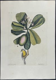
Catesby, Folio - American Goldfinch with Acacia. 1-43Trillium Antique Prints & Rare Books4.5(30)See Sold PriceFeb 24, 2024
Catesby, Folio - Bahama Titmouse with Seven Years Apple. 1-59Trillium Antique Prints & Rare Books4.5(30)See Sold PriceFeb 24, 2024
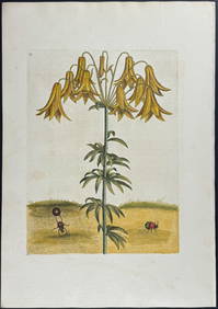
Catesby, Folio - American Partridge with Attamusco Lily. Sup-12Trillium Antique Prints & Rare Books4.5(30)See Sold PriceFeb 24, 2024
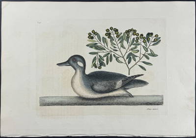
Catesby, Folio - Little Brown Duck with Soap-Wood. 1-98Trillium Antique Prints & Rare Books4.5(30)See Sold PriceFeb 24, 2024
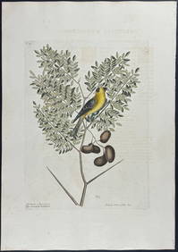
Catesby, Folio - Red Bellied Woodpecker & Hairy Woodpecker with Black Oak. 1-19Trillium Antique Prints & Rare Books4.5(30)See Sold PriceFeb 24, 2024
CAMERA SIMILAR TO SCOVILL & ADAMS COMPACT VIEWAustin Auction Gallery4.7(1.2k)See Sold PriceApr 12, 2024