ATLAS of ANTIENT GEOGRAPHY by SAMUEL BUTLER 1843John McInnis Auctioneers,LLC4.6(502)See Sold PriceFeb 24, 2024
18TH C. ANTIQUE MAP: FRENCH & INDIAN WAR, FRAMEDThomaston Place Auction Galleries4.4(386)See Sold PriceFeb 24, 2024
Rand McNally Railroad Map Cabinet w/ 21 Railroad MapsRail & Road Auctions4.6(165)See Sold PriceMar 08, 2024
Keith Haring - Ink on New York Map, Best Buddies, Inscribed, Signed, and DatedSapphire Auction Gallery4(67)See Sold PriceMar 02, 2024
LATE 17TH C. FRENCH MAP OF THE NEW WORLD BY ALEXIS-HUBERT JAILLOT (1632-1712)Thomaston Place Auction Galleries4.4(386)See Sold PriceFeb 24, 2024
Central Railroad of New Jersey Map of Sandy Hook Route-ca. 1903JM Hobby Supply and Railroad Artifact Auctions4.4(126)See Sold PriceFeb 24, 2024
Lot of Six Mixed Atlas Box Cars-HO Scale-New in BoxJM Hobby Supply and Railroad Artifact Auctions4.4(126)See Sold PriceFeb 25, 2024
Rand McNally/Santa Fe Railroad Map of Iowa-1912JM Hobby Supply and Railroad Artifact Auctions4.4(126)See Sold PriceFeb 24, 2024
NICOLAES VISSCHER (NETHERLANDS, 1618-1709) MAP OF THE NEW WORLDThomaston Place Auction Galleries4.4(386)See Sold PriceFeb 24, 2024
17TH C. WORLD MAP BY NICOLAES VISSCHER (NETHERLANDS, 1618-1709)Thomaston Place Auction Galleries4.4(386)See Sold PriceFeb 24, 2024
Lot of Six Mixed Atlas Cabooses-HO Scale-New in BoxJM Hobby Supply and Railroad Artifact Auctions4.4(126)See Sold PriceFeb 25, 2024
Antique Map Print - Europe - France and its Provinces - Paris - Vaugondy - 1806Title: Antique Map Print - Europe - France and its Provinces - Paris - Vaugondy - 1806 Date: 1806 Material: Paper Dimensions: 12” x 9” inches / 31,5 cm x 24 cm Descritpion: Original 1806 cSee Sold Price
Antique Map Print - Europe - France - Kingdon of Westphalia - Vaugondy - 1806Title/Artist: Antique Map Print - Europe - France - Kingdon of Westphalia - Vaugondy - 1806 Date: 1806 Material: Paper Dimensions: 31,5 cm x 24 cm Additional Information: Original 1778 copper-engravedSee Sold Price
Antique Map Print - Europe - Central Germany - Nuremberg - Vaugondy - 1806Title/Content: Antique Map Print - Europe - Central Germany - Nuremberg - Vaugondy - 1806 Date: 1806 Material: Paper Dimensions: 12” x 9” inches / 31,5 cm x 24 cm Description: Original 180See Sold Price
Antique Map Print - Europe - Northern Italy - Corsica - Milan - Vaugondy 1806Title/Content: Antique Map Print - Europe - Northern Italy - Corsica - Milan - Vaugondy 1806 Date: 1806 Material: Paper Dimensions: 12” x 9” inches / 31,5 cm x 24 cm Description: OriginalSee Sold Price
Antique Map Print - Europe - Bavaria - Austria - Robert de Vaugondy - 1806Title: Antique Map Print - Europe - Bavaria - Austria - Robert de Vaugondy - 1806 Date: 1806 Material: Paper Dimensions: 12” x 9” inches / 31,5 cm x 24 cm Descritpion: Original 1806 copperSee Sold Price
France (Paris & Cosica), 1850Original engraving by Thomas Cowperthwait from Mitchell’s Universal Atlas, 1850. Features a vignette of Paris & Corsica, including provinces. Dimensions: 14 x 16 inchesSee Sold Price
Antique Map Print - Europe - France - Guienne and Gascogne, Lower Navarre, BearnTitle/Content: Antique Map Print - Europe - France - Guienne and Gascogne, Lower Navarre, Bearn Date: 1778 Material: Paper Dimensions: 12” x 9” inches / 31,5 cm x 24 cm Description: OriginSee Sold Price
Antique Map Print - Europe - Map of France - Alsace, Strasbourg & Rhine RiverTitle: Antique Map Print - Europe - Map of France - Alsace, Strasbourg & Rhine River Date/Period: 1690 Dimension: 59 cm x 51 cm Material: Paper Additional Information: Alsatiae Landgraviatus, DucatusSee Sold Price
Antique Map Print - Europe - Map of Northern France - Somme and Bresle RiversEugene Henry Fricx (1644-1730). Les Embouchures de la Somme et de Bresle Riv. ou est St. Valeri, eu et Dieppe (northern France, Dieppe, Eu, Saint-Valery-sur-Somme). Map of the coast of northern FranceSee Sold Price
Antique Map of Europe - Map of France - Paris - Marseille - Francis BeckerTitle/Artist: Antique Map of Europe - Map of France - Paris - Marseille - Francis Becker Date/Period: 1843 Material: Paper Dimensions: 25 cm x 21 cm Description: Antique map of Europe by Becker, publiSee Sold Price
Antique Map Print - Europe - Scandinavia - Sweden - Stockholm - Vaugondy - 1778Title/Content: Antique Map Print - Europe - Scandinavia - Sweden - Stockholm - Vaugondy - 1778 Date: 1778 Material: Paper Dimensions: 12” x 9” inches / 31,5 cm x 24 cm Description: OriginaSee Sold Price
SoldAntique Map Print - America - Mexico - Brazil - California - Vaugondy - 1806Title: Antique Map Print - America - Mexico - Brazil - California - Vaugondy - 1806 Description: Original 1806 copper-engraved map by Robert de Vaugondy on the Mercator projection. Derived from "NouveSee Sold Price
Antique Map Print - Europe - Latest General Map of France - La Manche - AtlanticTitle: Antique Map Print - Europe - Latest General Map of France - La Manche - Atlantic Date: 1788 Material: Paper Dimensions: 22” x 19” inches / 57 cm x 48 cm Descritpion: A rare and extrSee Sold Price
Antique Map Print - Europe - Norway - Danemark - Oslo - Copenhagen - VaugondyTitle/Artist: Antique Map Print - Europe - Norway - Danemark - Oslo - Copenhagen - Vaugondy Date: 1778 Material: Paper Dimensions: 31,5 cm x 24 cm Additional Information: Original 1778 copper-engravedSee Sold Price
Antique Map Print - Europe - Map of Belgium - Luxembourg - Northern FranceTitle: Antique Map Print - Europe - Map of Belgium - Luxembourg - Northern France Date/Period: 1720 Dimension: 61 cm x 53 cm Material: Paper Additional Information: Johann Baptist Homann. Arena MartisSee Sold Price
Antique Map Print - Asia - Holy Land - Judea - Palestine - Vaugondy - 1806Title: Antique Map Print - Asia - Holy Land - Judea - Palestine - Vaugondy - 1806 Date: 1806 Material: Paper Dimensions: 12” x 9” inches / 31,5 cm x 24 cm Descritpion: Original 1806 copperSee Sold Price
Antique Map Print - Europe - British Isles - Great Britain - Ireland - VaugondyTitle/Content: Antique Map Print - Europe - British Isles - Great Britain - Ireland - Vaugondy Date: 1778 Material: Paper Dimensions: 12” x 9” inches / 31,5 cm x 24 cm Description: OriginaSee Sold Price
Antique Map Print - Asia - Indostan - India - China - Tartary - Vaugondy - 1806Title/Artist: Antique Map Print - Asia - Indostan - India - China - Tartary - Vaugondy - 1806 Date: 1806 Material: Paper Dimensions: 31,5 cm x 24 cm Additional Information: Original 1778 copper-engravSee Sold Price
Antique Map Print - Asia - Geography of Asian Turkey and Persia - Vaugondy 1806Title: Antique Map Print - Asia - Geography of Asian Turkey and Persia - Vaugondy 1806 Description: Original 1806 copper-engraved map by Robert de Vaugondy on the Mercator projection. Derived from "NoSee Sold Price
Antique Map Print - Europe - Map of Netherlands - Belgian Zeeland - Homann HeirsHomann Heirs. Antique map titled "Septem Provinciae seu Belgium Foederatum quod generliter Hollandia (..)." Detailed antique map of the seven provinces of the Belgian Federation (Dutch Federation), noSee Sold Price
SoldAntique 1806 Robert de Vaugondy Map of FranceAntique 1806 Robert de Vaugondy Map of France. Antique early 19th century hand colored engraving. Framed and matted. Measures 14.5 x 17 inches.See Sold Price
SoldSIX FRAMED ANTIQUE MAPSEurope, Spain, Greece, Paris-France, and Puerto Rico. Largest is 20" x 28"See Sold Price
1757 Imperium Caroli Magni Occidentis Imperatoris…By: Robert De Vaugondy Date: 1757 (Published) Paris Dimensions: 18.75 x 21.5 inches (47.6 cm x 54.6 cm) This is an authentic, antique map of Western Europe during the time of Charlemagne's empire by RSee Sold Price
Antique Map Print - Western Asia - Judea - Holy Land - Dead Sea - VaugondyTitle/Content: Antique Map Print - Western Asia - Judea - Holy Land - Dead Sea - Vaugondy Date: 1806 Material: Paper Dimensions: 12” x 9” inches / 31,5 cm x 24 cm Description: Original 180See Sold Price
Duval - Pair: Map of Georgia & Map of Moscow, RussiaTrillium Antique Prints & Rare Books4.5(30)See Sold PriceFeb 24, 2024
Duval - Pair: Map of India & Map of MaldivesTrillium Antique Prints & Rare Books4.5(30)See Sold PriceFeb 24, 2024
D'Entrecasteaux - Australia: Coasts of Van Diemen's Land (New Holland). 9Trillium Antique Prints & Rare Books4.5(30)See Sold PriceFeb 24, 2024
D'Entrecasteaux - Tasmania, Australia: Map of the Northern Portion of Recherche Bay. 5Trillium Antique Prints & Rare Books4.5(30)See Sold PriceFeb 24, 2024
D'Entrecasteaux - Australia: Chart of Van Diemen's Land (New Holland). 3Trillium Antique Prints & Rare Books4.5(30)See Sold PriceFeb 24, 2024
D'Entrecasteaux - Map of Australia (New Holland), New Zealand, and southern Asia and surroundingTrillium Antique Prints & Rare Books4.5(30)See Sold PriceFeb 24, 2024
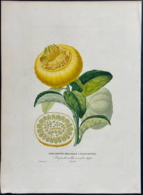
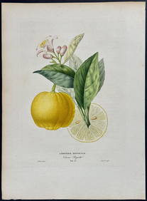
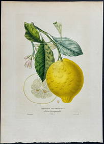
Risso - Lemon or Citrus Fruit. 73Trillium Antique Prints & Rare Books4.5(30)See Sold PriceFeb 24, 2024
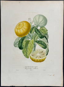
Risso - Lemon or Citrus Fruit. 71Trillium Antique Prints & Rare Books4.5(30)See Sold PriceFeb 24, 2024
Book: De Buonaparte, des Bourbons, et de la necessite de se rallier a nos princes legitimes, pour leClaydon Auctioneers Ltd4.3(125)See Sold PriceFeb 26, 2024
Bougainville's 1766 circumnavigation. France-Africa-Réunion. GENTS MAG 1774 mapJasper524.5(9.8k)See Sold PriceFeb 28, 2024
Bougainville's 1766 circumnavigation. France-Africa-Réunion. GENTS MAG 1774 mapJasper524.5(9.8k)See Sold PriceFeb 28, 2024
Afrique. Pays des Hottentots #50. Namibia South Africa VANDERMAELEN 1827 mapJasper524.5(9.8k)See Sold PriceFeb 28, 2024
World War 2 Europe Battle of the Atlantic 1939-43 Axis Expansion limits 1959 mapJasper524.5(9.8k)See Sold PriceFeb 28, 2024
Carte de L'Algérie et de la Régence de Tunis' ANDRIVEAU-GOUJON Algeria 1850 mapJasper524.5(9.8k)See Sold PriceFeb 28, 2024
Denis Diderot (1713 - 1784) & Jean Le Rond d’Alembert (1717 - 1783) - Set of 10 Military Prints -Proverde Auctions4.3(3)See Sold PriceFeb 28, 2024
Denis Diderot (1713-1784) & Jean Le Rond d’Alembert - Set of 10 Military Prints - Empty frame [forProverde Auctions4.3(3)See Sold PriceFeb 28, 2024
Carl Johan Billmark - Set of 4 Prints depicting Rome, Italy - Church in Sweden - Views of EuropeProverde Auctions4.3(3)See Sold PriceFeb 28, 2024