ATLAS of ANTIENT GEOGRAPHY by SAMUEL BUTLER 1843John McInnis Auctioneers,LLC4.6(502)See Sold PriceFeb 24, 2024
18TH C. ANTIQUE MAP: FRENCH & INDIAN WAR, FRAMEDThomaston Place Auction Galleries4.4(386)See Sold PriceFeb 24, 2024
Rand McNally Railroad Map Cabinet w/ 21 Railroad MapsRail & Road Auctions4.6(165)See Sold PriceMar 08, 2024
Keith Haring - Ink on New York Map, Best Buddies, Inscribed, Signed, and DatedSapphire Auction Gallery4(67)See Sold PriceMar 02, 2024
LATE 17TH C. FRENCH MAP OF THE NEW WORLD BY ALEXIS-HUBERT JAILLOT (1632-1712)Thomaston Place Auction Galleries4.4(386)See Sold PriceFeb 24, 2024
Central Railroad of New Jersey Map of Sandy Hook Route-ca. 1903JM Hobby Supply and Railroad Artifact Auctions4.4(126)See Sold PriceFeb 24, 2024
Lot of Six Mixed Atlas Box Cars-HO Scale-New in BoxJM Hobby Supply and Railroad Artifact Auctions4.4(126)See Sold PriceFeb 25, 2024
Rand McNally/Santa Fe Railroad Map of Iowa-1912JM Hobby Supply and Railroad Artifact Auctions4.4(126)See Sold PriceFeb 24, 2024
NICOLAES VISSCHER (NETHERLANDS, 1618-1709) MAP OF THE NEW WORLDThomaston Place Auction Galleries4.4(386)See Sold PriceFeb 24, 2024
17TH C. WORLD MAP BY NICOLAES VISSCHER (NETHERLANDS, 1618-1709)Thomaston Place Auction Galleries4.4(386)See Sold PriceFeb 24, 2024
Lot of Six Mixed Atlas Cabooses-HO Scale-New in BoxJM Hobby Supply and Railroad Artifact Auctions4.4(126)See Sold PriceFeb 25, 2024
Antique Map of the West Indies & Coast of Jamaica, 1888Map: West Indies. South Coast of Jamaica from Port Royal to Pedro Bluff. Publication Date: 1888 Authors: Hydrographic Offfice. U.S. Navy, Anonymous Publisher: Hydrographic Offfice. U.S. Navy Size: WalSee Sold Price
Colton: Antique Map of the West Indies, 1856West Indies from 1856 Colton Atlas of the World. Great hand colored map showing Cuba, Dominican Republic, Jamaica, Puerto Rico and the coasts of North America and South America. Excellent condition wiSee Sold Price
WEST INDIES. Sunset, North Coast, Jamaica 1905 old antique print pictureTITLE OF PRINT (NOT PRINTED ON THE PAGE):'Sunset, North Coast, Jamaica' DATE PRINTED: 1905 IMAGE SIZE: Approx 11.0 x 12.5cm, 4.25 x 4.75 inches (Small) TYPE: Coloured antique print CONDITION: Good; suSee Sold Price
WEST INDIES. Sunset, North Coast, Jamaica 1905 old antique print pictureTITLE OF PRINT (NOT PRINTED ON THE PAGE):'Sunset, North Coast, Jamaica' DATE PRINTED: 1905 IMAGE SIZE: Approx 11.0 x 12.5cm, 4.25 x 4.75 inches (Small) TYPE: Coloured antique print CONDITION: Good; suSee Sold Price
Kingston Harbour Port Royal Jamaica Caribbean ADMIRALTY chart 1960 (1966) mapTITLE/CONTENT OF MAP: 'West Indies - Jamaica - South Coast - Kingston Harbour including Port Royal // Ship Channel' DATE PRINTED: Surveyed 1949-1959. Published 1960. Corrections to 1966 IMAGE SIZE: ApSee Sold Price
Kingston approach Jamaica south coast Caribbean ADMIRALTY chart 1962 (1966) mapTITLE/CONTENT OF MAP: 'West Indies - Jamaica - South Coast - Approaches to Kingston' DATE PRINTED: Surveyed 1954-1956. Published 1962. Corrections to 1966 IMAGE SIZE: Approx 69.0 x 102.0cm, 27.25 x 40See Sold Price
Jamaica SE coast Morant-Portland Pt Kingston ADMIRALTY sea chart 1963 (1971) mapTITLE/CONTENT OF MAP: 'West Indies - Jamaica - South Coast - Morant Point to Portland Point' DATE PRINTED: Surveyed to 1962. Published 1963. Corrections to 1971 IMAGE SIZE: Approx 70.0 x 103.0cm, 27.5See Sold Price
Kingston approach Jamaica south coast Caribbean ADMIRALTY chart 1962 (1966) mapTITLE/CONTENT OF MAP: 'West Indies - Jamaica - South Coast - Approaches to Kingston' DATE PRINTED: Surveyed 1954-1956. Published 1962. Corrections to 1966 IMAGE SIZE: Approx 69.0 x 102.0cm, 27.25 x 40See Sold Price
Kingston Harbour Port Royal Jamaica Caribbean ADMIRALTY chart 1960 (1966) mapTITLE/CONTENT OF MAP: 'West Indies - Jamaica - South Coast - Kingston Harbour including Port Royal // Ship Channel' DATE PRINTED: Surveyed 1949-1959. Published 1960. Corrections to 1966 IMAGE SIZE: ApSee Sold Price
Jamaica SE coast Morant-Portland Pt Kingston ADMIRALTY sea chart 1963 (1971) mapTITLE/CONTENT OF MAP: 'West Indies - Jamaica - South Coast - Morant Point to Portland Point' DATE PRINTED: Surveyed to 1962. Published 1963. Corrections to 1971 IMAGE SIZE: Approx 70.0 x 103.0cm, 27.5See Sold Price
SoldSenex: Antique Map Jamaica & British West Indies, 1721Title/Content of Map: A new map of the English Empire in the Ocean of America or West Indies Cartographer: J. Senex Place & Date: London / 1721 Size: 23 3/4" x 20" Condition: full wash color; repairedSee Sold Price
SoldJamaica British West Indies Antique Map, 1835Map: Jamaica British West Indies Antique Map Size: 15.5"W × 0.1"D × 13.0"H Year: 1835 Please note that this lot has a confidential reserve. When you leave a bid in advance of the auction, submit youSee Sold Price
SDUK: Antique Map of the West Indies Islands, 1846Title/Content of Map: 'THE BRITISH ISLANDS IN THE WEST INDIES; Jamaica, Trinidad, Virgin Islands, Leeward Islands (St Christopher, Nevis, Barbuda, Antigua), St Lucie, St Vincent, Barbadoes, Tobago, DoSee Sold Price
Tallis: Antique Map of West Indies, 1853Title/Content of Map: West Indies by Tallis, circa 1853 (featuring Jamaica) Date Printed: 1853 Cartographer: John Tallis Material/Medium: Lithograph Dimensions: 10 3/4" x 13 3/4" Original lithograph bSee Sold Price
SoldSidney Hall: Antique Map of the West Indies, 1856Title/Content of Map: 'West Indies [inset: Panama Railway, Jamaica]' Date Printed: 1856 Image Size: Approx 29.0 x 42.0cm, 11.25 x 16.5 inches (Large) Type: Antique atlas map with original hand colouriSee Sold Price
SoldSDUK: Antique Map of British West Indies Islands, 1830The British Islands in the West Indies The typically detailed SDUK composite map of British possessions in the Caribbean. The large central map of Jamaica is surrounded by fourteen inset maps of indivSee Sold Price
SoldCram: Antique Map of the West Indies, 1892West Indies. Cram's large, highly detailed map of the West Indies from his Superior Atlas of the World features shipping routes and undersea cables. On the verso are two separate maps: "Jamaica, HaitiSee Sold Price
Antique Map of Cuba; Port Xagua Or Cienfuegos, 1884Map: West Indies. Cuba - South Coast. Port Xagua Or Cienfuegos. Publication Date: 1884-07-01 Authors: U.S. NAVY. HYDROGRAPHIC OFFICE, ANONYMOUS. SPANISH SURVEY 1836. Publisher: U.S. NAVY. HYDROGRAPHICSee Sold Price
West India Islands. West Indies Caribbean Jamaica Antilles. BARTHOLOMEW 1898 mapTITLE OF MAP (NOT PRINTED ON THE PAGE):'West India Islands' DATE PRINTED: 1898 IMAGE SIZE: Approx 29.5 x 40.5cm, 11.5 x 16 inches (Large) TYPE: Antique atlas map CONDITION: Good; suitable for framing.See Sold Price
West India Islands. West Indies Caribbean Jamaica Antilles. BARTHOLOMEW 1882 mapTITLE OF MAP (NOT PRINTED ON THE PAGE):'West India Islands' DATE PRINTED: 1882 IMAGE SIZE: Approx 30.5 x 41.0cm, 12 x 16.25 inches (Large) TYPE: Antique atlas map CONDITION: Good; suitable for framingSee Sold Price
West India Islands. West Indies Caribbean Jamaica Antilles. BARTHOLOMEW 1882 mapTITLE OF MAP (NOT PRINTED ON THE PAGE):'West India Islands' DATE PRINTED: 1882 IMAGE SIZE: Approx 30.5 x 41.0cm, 12 x 16.25 inches (Large) TYPE: Antique atlas map CONDITION: Good; suitable for framingSee Sold Price
West India Islands. West Indies Caribbean Jamaica Antilles. BARTHOLOMEW 1898 mapTITLE OF MAP (NOT PRINTED ON THE PAGE):'West India Islands' DATE PRINTED: 1898 IMAGE SIZE: Approx 29.5 x 40.5cm, 11.5 x 16 inches (Large) TYPE: Antique atlas map CONDITION: Good; suitable for framing.See Sold Price
Wyld: Antique Map of the West Indies, 1852Title: Map of the West India & Bahama Islands with the Adjacent Coasts of Yucatan, Honduras, Caracas &c. 1852 map of the West Indies by the Official Geographer to Queen Victoria Map maker: James WyldSee Sold Price
SoldGussefeld: Antique Map of the West Indies, 1804Charte von West Indien A large, dramatic, and delicately colored German map of the West Indies, extending from southern Florida and the Bahamas to the coasts of the Yucatan, Central America and northeSee Sold Price
Carey, pub. 1796 - A Chart of the West IndiesTrillium Antique Prints & Rare Books4.5(30)See Sold PriceFeb 24, 2024
Carey, pub. 1796 - Map of the State of MarylandTrillium Antique Prints & Rare Books4.5(30)See Sold PriceFeb 24, 2024
Carey, pub. 1796 - Map of GeorgiaTrillium Antique Prints & Rare Books4.5(30)See Sold PriceFeb 24, 2024
Carey, pub. 1796 - Map of The State of South CarolinaTrillium Antique Prints & Rare Books4.5(30)See Sold PriceFeb 24, 2024
Carey, pub. 1796 - Map of KentuckyTrillium Antique Prints & Rare Books4.5(30)See Sold PriceFeb 24, 2024
Carey, pub. 1796 - Map of the Tennassee State formerly part of North Carolina (Tennessee)Trillium Antique Prints & Rare Books4.5(30)See Sold PriceFeb 24, 2024
West Indies. South Coast of Jamaica from Port Royal to Pedro Bluff.Jasper524.5(9.8k)See Sold PriceFeb 27, 2024
West African birds. Ostrich pelican spoonbill bird of paradise 1747 old printJasper524.5(9.8k)See Sold PriceFeb 28, 2024
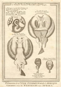
Coste Occidentale d’Afrique…' Arguin Bay Cap Blanc Mauritania. BELLIN 1746 mapJasper524.5(9.8k)See Sold PriceFeb 28, 2024
West coast of Africa from Cape Blanco… Arguin bay, Mauritania. LABAT 1745 mapJasper524.5(9.8k)See Sold PriceFeb 28, 2024
BRITISH AFRICAN COLONIES. West Africa Ascension St. Helena Mauritius 1876 mapJasper524.5(9.8k)See Sold PriceFeb 28, 2024
West African birds. Ostrich pelican spoonbill bird of paradise. SCHLEY 1747Jasper524.5(9.8k)See Sold PriceFeb 28, 2024
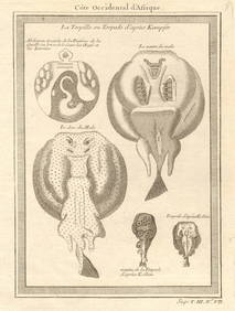
Coste Occidentale d’Afrique'. Bay of Arguin, Mauritania. BELLIN/SCHLEY 1747 mapJasper524.5(9.8k)See Sold PriceFeb 28, 2024
Côte occidentale de l'Afrique. W Africa.Senegal Gambia rivers.D’ANVILLE 1751 mapJasper524.5(9.8k)See Sold PriceFeb 28, 2024
Coste Occidentale d’Afrique…' West Africa. Gulf of Guinea. BELLIN 1746 mapJasper524.5(9.8k)See Sold PriceFeb 28, 2024
Gulf of Guinea. Ghana Togo Benin Nigeria. ADMIRALTY sea chart 1928 (1954) mapJasper524.5(9.8k)See Sold PriceFeb 28, 2024
South Namibia coast. Walvis Bay-Orange River ADMIRALTY sea chart 1881 (1954) mapJasper524.5(9.8k)See Sold PriceFeb 28, 2024
West African fish. Torpedo or electric rays after Kempfer. SCHLEY 1747 printJasper524.5(9.8k)See Sold PriceFeb 28, 2024
West African fish. Torpedo or electric rays after Kempfer 1747 old printJasper524.5(9.8k)See Sold PriceFeb 28, 2024
Coste Occidentale d’Afrique…' Namibia South Africa Angola coast BELLIN 1746 mapJasper524.5(9.8k)See Sold PriceFeb 28, 2024
Cooke, George 1801 Antique Map. West Indies CaribbeanAlbion Auctions4.6(336)See Sold PriceMar 01, 2024