ATLAS of ANTIENT GEOGRAPHY by SAMUEL BUTLER 1843John McInnis Auctioneers,LLC4.6(502)See Sold PriceFeb 24, 2024
18TH C. ANTIQUE MAP: FRENCH & INDIAN WAR, FRAMEDThomaston Place Auction Galleries4.4(386)See Sold PriceFeb 24, 2024
Rand McNally Railroad Map Cabinet w/ 21 Railroad MapsRail & Road Auctions4.6(165)See Sold PriceMar 08, 2024
Keith Haring - Ink on New York Map, Best Buddies, Inscribed, Signed, and DatedSapphire Auction Gallery4(67)See Sold PriceMar 02, 2024
LATE 17TH C. FRENCH MAP OF THE NEW WORLD BY ALEXIS-HUBERT JAILLOT (1632-1712)Thomaston Place Auction Galleries4.4(386)See Sold PriceFeb 24, 2024
Central Railroad of New Jersey Map of Sandy Hook Route-ca. 1903JM Hobby Supply and Railroad Artifact Auctions4.4(126)See Sold PriceFeb 24, 2024
Lot of Six Mixed Atlas Box Cars-HO Scale-New in BoxJM Hobby Supply and Railroad Artifact Auctions4.4(126)See Sold PriceFeb 25, 2024
Rand McNally/Santa Fe Railroad Map of Iowa-1912JM Hobby Supply and Railroad Artifact Auctions4.4(126)See Sold PriceFeb 24, 2024
NICOLAES VISSCHER (NETHERLANDS, 1618-1709) MAP OF THE NEW WORLDThomaston Place Auction Galleries4.4(386)See Sold PriceFeb 24, 2024
17TH C. WORLD MAP BY NICOLAES VISSCHER (NETHERLANDS, 1618-1709)Thomaston Place Auction Galleries4.4(386)See Sold PriceFeb 24, 2024
Lot of Six Mixed Atlas Cabooses-HO Scale-New in BoxJM Hobby Supply and Railroad Artifact Auctions4.4(126)See Sold PriceFeb 25, 2024
SoldAntique map lot, Brazil & South America, includes 4Antique map lot, Brazil & South America, includes 4 maps, "South America", by J & F Tallis, London, Edinburgh & Dublin; "Amerique Meridionale", Giraldon; "Brasil, Divided into its Captainships", H. MoSee Sold Price
SoldANTIQUE 19TH CENTURY ANTIQUE MAP LOT OF TWOLot contains two antique maps of South America. One is a copy of S Augustus Mitchell's map of Brazil, Bolivia, Paraguay, and Uruguay with separate map of Chile and inserts of the Harbor of Rio JaneiroSee Sold Price
SDUK: Antique Map of South Brazil, 1846Title/Content of Map: 'SOUTH AMERICA, SHEET III., SOUTH BRAZIL WITH PARAGUAY AND URUGUAY' The map includes some interesting brief anecdotes, eg "The Mate chiefly cultivated around Villa Rica" Bahia MiSee Sold Price
SoldAntique Maps by Augustus Mitchell (8)Various maps, including North America, South America, Europe, Italy, Spain, Greece, Brazil. Hand-colored engravings. S. Augustus Mitchell, Philadelphia, c. 1850. 17 1/2" x 14 1/4".See Sold Price
Sold2 antique maps, South America & Peru, includes "An2 antique maps, South America & Peru, includes "An accurate map of South America from the best modern Maps & Charts by Tho. Bowen, 12.5" by 17.75" (has water damage left margin) & "Peru", woodblock maSee Sold Price
SoldHarrison: Antique Map of South America & Mythical LakesMap: A New Map of South America . . . Published as the Act directs by Harrison & Co. Cartographer: Harrison Place & Date: London / 1785 Size: 9 3/4" x 7 1/2" Condition: b&w; light overall age toning,See Sold Price
Tallis: Antique Map of South America, 1851Title/Content of Map: 1851 Tallis Map of South America -- South America Date Printed: 1851, London Cartographer: J Tallis Size: 13.5 x 9.4 in. This is a very nice map of South America in the excellentSee Sold Price
Le Rouge: Antique Map of South America, 1748Map: Amerique Meridionale Cartographer: Le Rouge Place & Date: Pairs / 1748 Size: 11 3/4" x 8 1/4" Condition: outline color; light overall age toning Le Rouge's fascinating South America map from hisSee Sold Price
Rossi: Antique Map of South America / Oceania, 1821Map: L'America Meridionale Cartographer: Rossi Place & Date: Milan / 1821 Size: 27 3/4" x 15 3/4" Condition: outline color; light overall age toning and minor smudging The distinctively engraved SouthSee Sold Price
Tallis: Antique Map of South America, 1851Title/Content of Map: 1851 Tallis Map of South America -- South America Date Printed: 1851, London Cartographer: J Tallis Size: 13.5 x 9.4 in. This is a very nice map of South America in the excellentSee Sold Price
Finley: Antique Map of South America, 1829Map: South America Cartographer: A. Finley Place & Date: Philadelphia / 1829 Size: 8 3/4" x 11 1/2" Condition: full color; light overall age toning An attractive, beautifully colored South America proSee Sold Price
Greenleaf: Antique Map of South America, 1842Map: South America Cartographer: Greenleaf Place & Date: Brattleboro (Vermont) / 1842 Size: 10 3/4" x 12 1/2" Condition: full color; overall age toning A beautifully colored exemplar of Greenleaf's scSee Sold Price
Russell: Antique Map of South America, 1794Map: A General Map of South America Drawn from the best Surveys Cartographer: Russell Place & Date: London / 1794 Size: 17 3/4" x 14 1/2" Condition: outline color; light overall age toning; repaired sSee Sold Price
SoldOrtelius: Antique Map of North & South America, 1598Map: America sive Novus Orbis Date Printed: 1598 Cartographer: Abraham Ortelius Size: 4 x 3 Condition: Good condition. A few brown thumbprints and one repaired marginal tear at the Northwest coast ofSee Sold Price
SoldCassini: Antique Map of Northern South America, 1798Map: La Terra Ferma e la Guiana Co' suoi departimenti Cartographer: Cassini Place & Date: Rome / 1798 Size: 14 1/4" x 19 1/4" Condition: outline color; light overall age toning; some fraying on outerSee Sold Price
Tallis: Antique Map of Northern South America, 1850Map: Venezuela, New Granada, Equador, and the Guayanas Cartographer: John Tallis Place & Date: London / 1850 Size: 12 3/4" x 9 3/4" Condition: outline and wash color; overall age-toning, two small nicSee Sold Price
SDUK: Antique Map of Amazonia, Brazil Ecuador 1846TITLE/CONTENT OF MAP: 'SOUTH AMERICA, SHEET I., ECUADOR, NEW GRANADA, VENEZUELA AND PARTS OF BRAZIL AND GUYANA' This fascinating map of the North West part of South America/Amazonia covers Ecuador, NeSee Sold Price
SoldBartholomew, John 1922 Lot of 4 Maps. South AmericaLarge Lithograph Maps Published 1922 by The Times, London for "The Times Survey Atlas of the World" Maps by John George Bartholomew of the Edinburgh Geographical Institute. Centre fold as issued. PapeSee Sold Price
Mallet: Antique Map of South America, 1683Title of the Map: 'Païs qui sont aux environs de la riviere de la Plata et du païs des Patagons' SOUTH AMERICA. La Plata. Brazil Peru Chile Patagonia Tribes. The Map runs from Brazil to Tierra dSee Sold Price
Mallet: Antique Map of South America, 1683TITLE OF THE MAP: 'Païs qui sont aux environs de la riviere de la Plata et du païs des Patagons' The Map runs from Brazil to Tierra del Fuego. SOUTH AMERICA. La Plata. Brazil Peru Chile Patagonia TrSee Sold Price
SoldMaps 1799-C1900 Mixed Lot of 7 Antique MapsIncl Germany/Swtizerland, South America, Alexander the Great, Asia Minor, and France. Examples by Delemarche, Monthly Magazine, Rapkin, and Philip. Paper Size: Up to 21 x 14.5 inch (54 x 37cm) Good CoSee Sold Price
SoldMaps C1840-1905 Mixed Lot of 10 Antique MapsIncl Cape of Good Hope, Monmouthshire, South America, North Asia, East Canada, West Siberia, Scotland, Greece, Russia, and Turkey. Examples by Encyclopaedia Brittannica, Stieler, Butler, and Moule. PaSee Sold Price
SoldGrp: 4 Maps of South America and the Caribbean SaGroup of four maps of South America and the Caribbean. Includes William Faden (1749–1836), "New Andalusia or Province of Guyana, according to the modern Division of the Spaniards, which extendsSee Sold Price
SoldSouth America C1830-1890s Lot of 5 MapsIncl South America Continent, Brazil, and Columbia/Venezuela/Ecuador/Peru/Bolivia. Three Lithograph Maps and One Hand Colored Copper Engraved Map Published C1835, London for "A Complete and UniversalSee Sold Price
Carey, pub. 1796 - Map of KentuckyTrillium Antique Prints & Rare Books4.5(30)See Sold PriceFeb 24, 2024
Carey, pub. 1796 - Map of the Tennassee State formerly part of North Carolina (Tennessee)Trillium Antique Prints & Rare Books4.5(30)See Sold PriceFeb 24, 2024
Audubon, Imperial Folio - 4 Lithographs of Squirrel, Rat, MiceTrillium Antique Prints & Rare Books4.5(30)See Sold PriceFeb 24, 2024
A quantity of assorted 20thC flags and pennants to include South Africa, Malta, Senegal, Cornwall,Claydon Auctioneers Ltd4.3(125)See Sold PriceFeb 26, 2024
South Asian School, Ink and wash, Four studies to include bamboo, two figures cycling and boatClaydon Auctioneers Ltd4.3(125)See Sold PriceFeb 26, 2024
Map: A 19thC engraved and hand coloured map of South America. Published by the Society for theClaydon Auctioneers Ltd4.3(125)See Sold PriceFeb 26, 2024
Map: An 18thC engraved and hand coloured map of North America and South America, titled DeClaydon Auctioneers Ltd4.3(125)See Sold PriceFeb 26, 2024
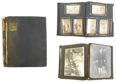
An early 20thC photograph and postcard album containing various South American scenes to includeClaydon Auctioneers Ltd4.3(125)See Sold PriceFeb 26, 2024
1822 MAP of SOUTH AMERICA GEOGRAPHICAL STATISTICAL HISTORICAL antique 17.5x 22"Jasper524.5(9.8k)See Sold PriceFeb 27, 2024
1822 MAP of NORTH & SOUTH AMERICA GEOGRAPHICAL STATISTICAL HISTORICAL antiqueJasper524.5(9.8k)See Sold PriceFeb 27, 2024
Antique Farm Tractors & Trolleys VHS TapesRapid Estate Liquidators and Auction Gallery4.5(1.1k)See Sold PriceFeb 28, 2024
Antique Britains LTD Lead Hand Painted Civil War 2" Soldiers Queens Royal GuardsRapid Estate Liquidators and Auction Gallery4.5(1.1k)See Sold PriceFeb 28, 2024
3 Vintage Collectable Guide BooksRapid Estate Liquidators and Auction Gallery4.5(1.1k)See Sold PriceFeb 28, 2024
TWO ANTIQUE JEWISH NATIONAL FUND CHARITY BOXES. The first one made in Berlin c. 1920J. Greenstein & Co., Inc.4.3(55)See Sold PriceApr 16, 2024