ATLAS of ANTIENT GEOGRAPHY by SAMUEL BUTLER 1843John McInnis Auctioneers,LLC4.5(505)See Sold PriceFeb 24, 2024
18TH C. ANTIQUE MAP: FRENCH & INDIAN WAR, FRAMEDThomaston Place Auction Galleries4.4(393)See Sold PriceFeb 24, 2024
Rand McNally Railroad Map Cabinet w/ 21 Railroad MapsRail & Road Auctions4.6(165)See Sold PriceMar 08, 2024
Keith Haring - Ink on New York Map, Best Buddies, Inscribed, Signed, and DatedSapphire Auction Gallery4(67)See Sold PriceMar 02, 2024
LATE 17TH C. FRENCH MAP OF THE NEW WORLD BY ALEXIS-HUBERT JAILLOT (1632-1712)Thomaston Place Auction Galleries4.4(393)See Sold PriceFeb 24, 2024
Central Railroad of New Jersey Map of Sandy Hook Route-ca. 1903JM Hobby Supply and Railroad Artifact Auctions4.4(127)See Sold PriceFeb 24, 2024
Lot of Six Mixed Atlas Box Cars-HO Scale-New in BoxJM Hobby Supply and Railroad Artifact Auctions4.4(127)See Sold PriceFeb 25, 2024
Rand McNally/Santa Fe Railroad Map of Iowa-1912JM Hobby Supply and Railroad Artifact Auctions4.4(127)See Sold PriceFeb 24, 2024
NICOLAES VISSCHER (NETHERLANDS, 1618-1709) MAP OF THE NEW WORLDThomaston Place Auction Galleries4.4(393)See Sold PriceFeb 24, 2024
17TH C. WORLD MAP BY NICOLAES VISSCHER (NETHERLANDS, 1618-1709)Thomaston Place Auction Galleries4.4(393)See Sold PriceFeb 24, 2024
Lot of Six Mixed Atlas Cabooses-HO Scale-New in BoxJM Hobby Supply and Railroad Artifact Auctions4.4(127)See Sold PriceFeb 25, 2024
SoldAntique Map Georg Matthaus Seutter 18th C.18th C. antique map is third state of Seutter's map based on Jansson's map of 1651. Hand colored and embellished with decorations and animal figures. Shows boundaries of Massachusetts, New England, NeSee Sold Price
Sold(3) ANTIQUE MAPS, SPAIN, PORTUGAL, SAXONY, 18TH C.(lot of 3) Antique maps, including: (1) "Saxonie Inferioris Circulus...," c.1730, Georg Matthaus Seutter (German, 1678-1757), hand colored, approx 20.5"h, 23.75"w; (1) "La Catalogna Li Regni Di AragonSee Sold Price
Sold18th c. Hand-colored mapSeutter, Georg Matthaus 18th c. hand-colored map- ''Plan De La Cupitale Et Fortresse Midolebour...Augsbourg''- Town plan in color with an uncoloured general view above bottom margin, embellished withSee Sold Price
SoldSeutter, Hand Colored Map, Central Asia, 18th C.German, circa 1770. "Imperi Magni Mogolis sive Indici Padschach"-circa 1740, hand colored copperplate cartographic engraving by Georg Matthäus Seutter (German, 1678-1757) published in Ausburg. A GermSee Sold Price
SoldSeutter, Hand Colored Map, Asia Minor, 18th C.German, circa 1770. "Natoliae olim Asiae Minoris Tabula per Matth. Seutterum"-circa 1770, hand colored copperplate cartographic engraving by Georg Matthäus Seutter (German, 1678-1757) published in AuSee Sold Price
SoldHand-Colored Copper Engraved Antique Maps(lot of 2) Matthäus Seutter III (German, 1678-1757), Roterodami Delineatio Ichnographica et Scenographica opera, and Heredibus Homanni (18th c.), Haga Comitum (Prospect von Graven Haag), hand-coloredSee Sold Price
Sold18thC Hand-Colored Map, Germany, M. Seutter18th century hand-colored map, Germania Augustiniana by Matthaus Seutter, S.C.M. (German, 1678-1757), framed 28" x 31". Provenance: Del Mar, California collection.See Sold Price
SoldMatthaus Seutter hand colored engraved mapMatthaus Seutter hand colored engraved map, early 18th c., inscribed Europa Religionis Christianae Morum et Pacis ac Belli Artium Cultu Omnium Terrarum Orbis Partium Praestantiss...., 20'' x 23''. ProSee Sold Price
SoldSeutter rare gore pairingSeutter, Georg Matthaus. 1678-1757. Globus Terrestris; Globus Celestis. Augsburg: [c.1710]. Seutter, Georg Matthaus. 1678-1757. Globus Terrestris; Globus Celestis. Augsburg: [c.1710]. 6 hand-colored eSee Sold Price
SoldA LARGE 18TH C HAND COLORED MAP OF RUSSIAA LARGE 18TH C HAND COLORED MAP OF RUSSIA. Comprising a large finely engraved map entitled "MAPPAE IMPERII MOSCOVITICI PARS SEPTENTRIONALIS," by George Matthäus Seutter (1678-1757) printed in AugsburSee Sold Price
Seutter World MapSEUTTER, Georg Matthaus (1678-1757). [World Map] Diversi Globi terr-Aquei statione variante et visu interxedente. Engraved map with hand color. Augsburg: c. 1730. 21 1/4" x 25" sheet. The double-hemisSee Sold Price
SoldGeorg Matthaus Seutter, Framed Map of CreteFramed map of Crete by map maker Georg Matthaus Seutter. Titled: Insula Creta nunc Candia, Date : Augsburg, 1741. Hand-colored map divided into its four territories, and the islands to its north. TheSee Sold Price
SoldSixteen Antique French MapsSixteen Antique French Maps , 18th c., by Amedee Francois Frezier, 9 in. x 12 1/2 in Provenance: Property deaccessioned from the Louisiana State Museum, proceeds to be used for new acquisitions or theSee Sold Price
(3) ANTIQUE MAPS, GERMANY, 17TH & 18TH C.(lot of 3) Antique maps, including: (1) "Dithmarshen" (Northern Germany), with inset maps of "Brunsbuttel, 1644" and "Meldorpia, 1500," Johannes Mejer (German, c.1606-1674), hand colored, including seSee Sold Price
SoldGroup of Three Antique Maps, 19th and 18th c.,Group of Three Antique Maps, 19th and 18th c., consisting of "Prussian Dominions" from Pinkerton's Modern Atlas; Jean Baptiste D'Anville, "Germanie, France, Italie, Espagne, Isles Britanniques," 1771;See Sold Price
Sold6 Maps incl: Seutter. Majestas Austriaca...[Austria/DC/Ancient World] 6 Maps. ++ Matthaus Seutter. Majestas Austriaca… C. 1730s-1740s. Detailed map showing rivers and towns in Austria. Hand colored. Border: 19 1/8 x 22 in. Frame: 30 1/2 x 35See Sold Price
SoldThree Antique New Orleans MapsThree Antique New Orleans Maps, 18th c., incl. 2 from Bellin's Petit Atlas Maritime and one published by London Magazine, sights 7 1/2 in. x 9 in. to 8 1/2 in. x 11 3/4 in., framed alikeSee Sold Price
Sold18TH c. Antique Map of the Americas, CARTE DEL AMERIQUE18TH c. Antique Map of the Americas, CARTE DEL AMERIQUE, approx. 21" x 31" sightSee Sold Price
SoldMatthaus Seutter, Map, c. 1740Matthaus Seutter, "Mappa Geographica Regionem Mexicanam et Floridam...", Augsburg, c. 1740, hand-colored, with inset maps of Havana, Portobell, Cartagena and Vera Cruz, with vignettes of a sea battleSee Sold Price
Antique European Map Spain & Portugal, 18th CAntique European Map Spain & Portugal. Matted dimensions ca 30x24 plate 27. 18th century Please note that this lot has a confidential reserve. When you leave a bid in advance of the auction, submit yoSee Sold Price
Sold18th C. Seutter Map of India including SE Asia.Approx 1740. Dimensions: 19.3" h x 23.5" image. Condition: Appears good, age appropriate, not examined outside frame.See Sold Price
SoldMATTH. SEUTTER 18TH C. MAP OF AMSTERDAMCa. mid 18th c. hand-colored map. Fold down the center. 19.25 x 22.25" sight.See Sold Price
Georg Matthaus Seutter map Lithuania LithuanianGeorg Matthaus Seutter I (1678 - 17560 ir Georg Matthaus Seutter (1729 - 1760) Novisima et accuratisima MAGNI DUCATUS LITHUANIe... Apie 1740, Augsburgas, Spalvintas vario raizinys, 49 x56,7See Sold Price
SoldAlbrecht Carl Seutter, 18th C. Map of DenmarkAlbrecht Carl Seutter (German, 1722-1762), ""Daniae Regni Typus", engraving with hand coloring on paper, lower right margin with "A.C. Seutter delin 14". Hand colored map depicting Denmark, title in rSee Sold Price
18TH C. ANTIQUE MAP: FRENCH & INDIAN WAR, FRAMEDThomaston Place Auction Galleries4.4(393)See Sold PriceFeb 24, 2024
ANTIQUE 18TH C ORNATE GILT BRASS WOOD WALL MIRRORAntique Arena Inc.4.5(878)See Sold PriceFeb 24, 2024
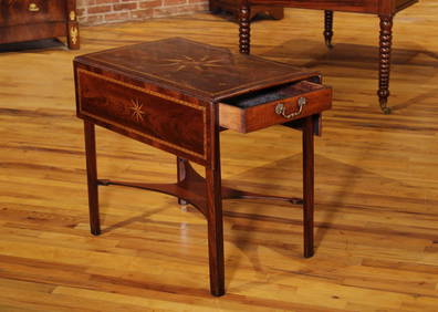
Antique 18th C Italian Walnut Drop Side TableAshcroft and Moore LLC4.5(277)See Sold PriceMar 12, 2024
Two (2) Antique 18th C. Copper Engraved Framed Maps - America & EuropeMagnusson Art Group4.5(53)See Sold PriceMar 14, 2024
Map: An 18thC engraved and hand coloured map of Buckinghamshire after Robert Morden. Approx. 8 1/4"Claydon Auctioneers Ltd4.3(125)See Sold PriceFeb 26, 2024
Map: An 18thC engraved and hand coloured map of Northamptonshire, with description ofClaydon Auctioneers Ltd4.3(125)See Sold PriceFeb 26, 2024
Map: An 18thC engraved and hand coloured map of North America and South America, titled DeClaydon Auctioneers Ltd4.3(125)See Sold PriceFeb 26, 2024
Map: An 18thC engraved map of Bedfordshire titled An Accurate Map of the County of Bedford DividedClaydon Auctioneers Ltd4.3(125)See Sold PriceFeb 26, 2024
Map: An 18thC engraved map titled A New and Improved Map of Oxfordshire.. after Thomas Kitchin.Claydon Auctioneers Ltd4.3(125)See Sold PriceFeb 26, 2024
1571 PICTURE BIBLE antique ILLUSTRATED w/ 200 WOODCUTS by JOST AMMAN RARE 16th CJasper524.5(9.9k)See Sold PriceFeb 27, 2024
1758 MAP PARTIE DE LA MER GLACIALE contenants La Nouvelle Zemble RUSSIA antiqueJasper524.5(9.9k)See Sold PriceFeb 27, 2024
ANTIQUE 18TH C ENGLISH MALE PORTRAIT OIL PAINTINGAntique Arena Inc.4.5(878)See Sold PriceMar 02, 2024
ANTIQUE 18TH C FRENCH ORMOLU AND MARBLE CANDELABRAAntique Arena Inc.4.5(878)See Sold PriceMar 02, 2024
ANTIQUE ROMAN ARMORIAL VELLUM BINDING, 1744, ILLUSTRATED WITH AN ANTIQUE MAP BY FLORUSNY Elizabeth 4.2(86)See Sold PriceMar 03, 2024
ANTIQUE 18TH C FEMALE PORTRAIT WATERCOLOR PAINTINGAntique Arena Inc.4.5(878)See Sold PriceMar 09, 2024
ANTIQUE 18TH C FRENCH ORMOLU AND MARBLE CANDELABRAAntique Arena Inc.4.5(878)See Sold PriceJun 15, 2024