SoldANTIQUE HAND COLORED HEINRICH SCHERER MAP 1702Scarce hand colored antique map of Europe by the Jesuit Heinrich Scherer, printed in 1702. Copper engraving with later hand coloring. Professionally framed and matted. The overall size of the map is 1See Sold Price
SoldTwo Antique Maps: Arnoldus C. Montanus (1625-1683),Two Antique Maps: Arnoldus C. Montanus (1625-1683), "Chili," 1670, hand colored, presented in a black frame with a gilt liner, H.- 11 3/4 in., W.- 14 1/2 in; and Heinrich Scherer (1628-1704), "Imago TSee Sold Price
America Australis. 1699.[South America] Scherer, Heinrich. “America Australis.” Munich, 1699. Engraved map. 13 7/8” x 8 7/8”. Framed: 18 1/4” x 13 3/8”. Hand-colored. Colored cartouche._x0See Sold Price
SoldSCHERER, HEINRICH. Idea Naturalis Americae BorealisSCHERER, HEINRICH. Idea Naturalis Americae Borealis Digito Dei Formata Geographice Proposita. Hand-colored double-page engraved decorative map of North America showing California as an island and an eSee Sold Price
SoldAntique Hand-colored MapAntique Hand-colored Map of Russia and Neighboring Countries: Russiae, Moscoviae et Tartariae Descriptio, 1562 by Anthony Jenkinson. Size: 14.25" x 18", 36 x 46 cm (sight); 22.25" x 26", 57 x 66 cm (fSee Sold Price
Sold2 Antique Hand Colored Maps East & West Indies2 Antique Hand Colored Maps of The East & West Indies. Including map of Batavia and Jamaica Map measures 17 inches high x 21 inches wide. Frame measures 19 inches high x 23 inches wide.See Sold Price
SoldAN ANTIQUE HAND COLORED MAP, "Republic of Mexico andAN ANTIQUE HAND COLORED MAP, "Republic of Mexico and Texas," hand colored engraving on paper, "London, James Wyld, Charing Gros.," plate number 46, originally printed for Popular Atlas of the World (See Sold Price
SoldAntique Hand-colored Map: Landt Carte Vonden DanischenAntique Hand-colored Map: Landt Carte Vonden Danischen Walde, c. 1650. Size: 9.75" x 12.25", 25 x 31 cm (sheet); 14.5" x 16.75", 37 x 43 cm (frame). Provenance: Estate of Eileen Ford, Tewksbury, New JSee Sold Price
SoldANTIQUE HAND COLORED MAPDepicting the Carolinas. Measuring 20” by 24”. Framed under Plexiglas. (Cond: toning, foxing) (300/400)See Sold Price
SoldANTIQUE HAND COLORED MAP OF "BURGUNDY""Amsterdami, Apud Guilielmum Blaeu. Sight measuring 16" by 20 3/4". Gilded frame. (Cond: some fading with center fold, with margins) (80/120)See Sold Price
SoldAntique Hand Colored Map Of SuffolkAntique Hand Colored Map Of Suffolk . 18 1/2" X 16 1/4"See Sold Price
SoldANTIQUE HAND COLORED MAP OF NEWPORT, RI19th Century hand-colored engraving; map of Newport County, RI. Unframed, with mat and board. Apparently unsigned. Dimensions (Mat) H 20" x W 16" (Sight) H 15" x W 12" Condition: Matting with light soSee Sold Price
Fine antique hand colored map of AsiaTitle/Content of Map: Fine antique hand colored map of Asia Date Printed: 1729 Cartographer: Duchesne, J.B.P. Size (in): 7 x 5 Interesting small antique map of Asia by the Jesuit J.B.P. Duchesne publiSee Sold Price
SoldAntique Hand Colored Map - Carte D'AfriqueParisian hand colored map of Africa 1772; 20in. X 25.25in.See Sold Price
SoldAntique Hand Colored Map of JapanA striking map of the island of Japan. Shows provinces, islands, towns, mountains, rivers, islands etc.Sight size: 8.25 x 12 inches.See Sold Price
Sold1818 ANTIQUE HAND COLORED MAP OF IRELANDThomsons New General Atlas 1815 Dimensions: (Frame) H 32.75" x W 28.5" (Sight) H 24.5" x W 20.5" Condition: Map with fold as published. Some age toning to paper, slipped in frame. Frame with small damSee Sold Price
SoldBritanna Romana Antique Hand Colored Map by Robert Morden, 1722Britanna Romana antique hand colored map. Originally by Robert Morden (1650 – 1703). Map depicting British Isles from Camden's Britannia, there is a fold in the middle where it was folded intoSee Sold Price
SoldAntique hand colored map of Europe, "Europa ExactissimaAntique hand colored map of Europe, "Europa Exactissima Descripta", engraving on paper after the original by Henricus Hondius, 15" x 20" plate, framed 20" x 26", good condition with toning, not examinSee Sold Price
SoldAntique Hand Colored Maps of Fairfield County CTAntique Hand Colored Maps of Fairfield County CT. This lot includes three 19th century hand colored maps from the "Atlas of Fairfield County CT" by F.W. Beers. Includes one map of Bethel, one map of DSee Sold Price
SoldAntique Hand Colored Maps of Westchester County NYAntique Hand Colored Maps of Westchester County NY. This lot includes four 19th century hand colored maps from the "Atlas of New York and Vicinity" by F.W. Beers. Includes one map of Mamaroneck/Rye NeSee Sold Price
SoldAntique Hand Colored Maps of Westchester County NYAntique Hand Colored Maps of Westchester County NY. This lot includes four 19th century hand colored maps from the "Atlas of New York and Vicinity" by F.W. Beers. Includes one map of Bedford, one mapSee Sold Price
SoldAntique Hand Colored Map Titled MappeAntique Hand Colored Map Mappe-Monde Indiquant les Possessions Coloniales des diverses Puissances By Drioux, Claude Joseph (1820 - 1898) [M. Drioux et Ch. Leroy] | Published Paris, Belin, 1859 | 19thSee Sold Price
SoldAN ANTIQUE HAND COLORED MAP, "United States and Texas,"AN ANTIQUE HAND COLORED MAP, "United States and Texas," CIRCA 1843, engraving on paper with hand coloring and small map, "Stretch of the River Niagara," plate thirty nine, published "Edinburg, John JSee Sold Price
MAP - PIETER SCHENK / VALK / JANSSEN Hand Colored superb Map Central Italy c1702Luis Porretta Fine Arts4.3(10)See Sold PriceMar 02, 2024
PIETER SCHENK / VALK / JANSSEN Hand Colored Map of Rhodes Greece ca1702 vgcLuis Porretta Fine Arts4.3(10)See Sold PriceMar 02, 2024
Johann Homann Hand-Colored Map Engraving, c. 1730Auctions at Showplace4.5(726)See Sold PriceMar 17, 2024
Framed Hand Colored Antique Map of the Department of Nord, FranceDonny Malone Auctions4.5(1.7k)See Sold PriceMar 04, 2024
D'Oyly (Calcutta, India) - Procession of the CurruckpoojaTrillium Antique Prints & Rare Books4.5(30)See Sold PriceFeb 24, 2024
Mitchell - Map of the City of Washington (Washington, DC)Trillium Antique Prints & Rare Books4.5(30)See Sold PriceFeb 24, 2024
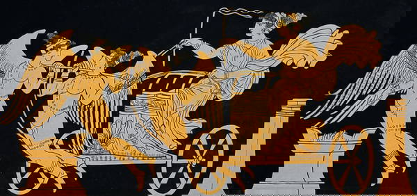
Hamilton - Engraving of a Painting from a Grecian Vase. 1Trillium Antique Prints & Rare Books4.5(30)See Sold PriceFeb 24, 2024
Hamilton - Engraving of a Painting from a Grecian VaseTrillium Antique Prints & Rare Books4.5(30)See Sold PriceFeb 24, 2024
Hamilton - Engraving of a Painting from a Grecian Vase. 2Trillium Antique Prints & Rare Books4.5(30)See Sold PriceFeb 24, 2024
Hamilton - Engraving of a Painting from a Grecian Vase. 32Trillium Antique Prints & Rare Books4.5(30)See Sold PriceFeb 24, 2024
Hamilton - Engraving of a Painting from a Grecian Vase. 114Trillium Antique Prints & Rare Books4.5(30)See Sold PriceFeb 24, 2024
Hamilton - Engraving of a Painting from a Grecian Vase. 5Trillium Antique Prints & Rare Books4.5(30)See Sold PriceFeb 24, 2024
Kipling's Les plus beaux contes - 24 Engravings by Kees Van DongenTrillium Antique Prints & Rare Books4.5(30)See Sold PriceFeb 24, 2024
Audubon - Common Osprey Fish Hawk. 15Trillium Antique Prints & Rare Books4.5(30)See Sold PriceFeb 24, 2024
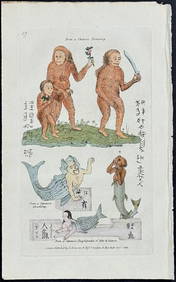
Donovan - Mermaid, Merman, & Rufous Orang Outang (Orangutan). 59Trillium Antique Prints & Rare Books4.5(30)See Sold PriceFeb 24, 2024
Wilson - Carolina Parrot & Flycatchers. 26Trillium Antique Prints & Rare Books4.5(30)See Sold PriceFeb 24, 2024
1849 Hand Colored Blair Map of World in HemispheresMatthew Bullock Auctioneers4.7(1.8k)See Sold PriceMar 02, 2024
1849 Orr & Co. Hand Colored Southern Germany MapMatthew Bullock Auctioneers4.7(1.8k)See Sold PriceMar 02, 2024